
Peloponnese tours cover the peninsula of southern Greece beyond the Corinth Canal: the royal citadel of Mycenae, the theatre of Epidaurus, the first capital at Nafplio, Ancient Olympia, Byzantine Mystras, the rock of Monemvasia and the tower villages of the Mani. Plan the rest of the trip with Greece Tours.
This page covers the Peloponnese tours you can book from Athens and inside the peninsula, the sites and towns they reach, the food and wine, the outdoor trips, the islands off the coast, and how to plan the route.
What do Peloponnese tours cover?
Peloponnese tours cover the peninsula south of the Corinth Canal: Mycenae, Epidaurus, Ancient Olympia, Nafplio, Mystras, Monemvasia and the Mani. They run as day trips from Athens, multi-day circuits, private drives, shore excursions, and food, wine and outdoor trips.
The Peloponnese is the southernmost part of mainland Greece. It covers 21,549.6 square kilometres. The Isthmus of Corinth joins it to the rest of the country. The Corinth Canal has cut through that isthmus since 1893. In the north-west, the Rio–Antirrio bridge links the peninsula to the mainland near Patras. From the late Middle Ages to the 19th century, the peninsula was called the Morea. Its modern name comes from Pelops, the mythical hero said to have conquered the whole region.
Peloponnese tours cross seven historic regions. Achaea lies in the north, Corinthia in the north-east and Argolis in the east. Arcadia holds the mountain heart of the peninsula. Laconia lies in the south-east, Messenia in the south-west and Elis in the west. Patras, in Achaea, is the largest city. Kalamata, in Messenia, is the second largest.
The land shapes every route. Four peninsulas point south: the Argolid, the Messenian peninsula, the Mani and Cape Malea. Mount Taygetus rises to about 2,400 metres above Sparta and Kalamata, the highest point of the Peloponnese. Cyllene, Aroania, Erymanthos, Mainalo and Parnon all pass 1,900 metres. The Alfeios is the longest river, at 110 km, and it flows past Ancient Olympia. The Evrotas runs 82 km through the valley of Sparta.
Which eras do Peloponnese tours cover?
Peloponnese tours walk through five thousand years in three or four days. The Mycenaean palaces of Mycenae, Tiryns and Pylos ruled here between about 1600 and 1100 BC. Classical city-states followed: Sparta, Argos, Corinth and Messene. Olympia, Nemea and Isthmia held three of the four Panhellenic games. Rome rebuilt Corinth as the capital of its province of Achaea.
The Middle Ages left the castles and churches. Byzantine Mystras and Monemvasia grew into walled towns. After the Fourth Crusade, Frankish lords founded the Principality of Achaea and built Chlemoutsi, Karytaina and the first fortress of Mystras. Venice held Nafplio, Methoni and Koroni and built the Palamidi fortress. The Ottomans ruled until the War of Independence. That war began here in March 1821, at Agia Lavra near Kalavryta and at Areopoli in the Mani.
Modern Greece also started in the Peloponnese. The allied fleets won the Battle of Navarino at Pylos in 1827. Nafplio served as the first capital of the new Greek state from 1827 to 1834. Peloponnese tours that stay three days or more see each of these layers in its own place.
Which Peloponnese tours reach UNESCO sites?
Peloponnese tours reach five UNESCO World Heritage sites. The Temple of Apollo Epicurius at Bassae was the first Greek site on the list, in 1986. The theatre and sanctuary of Epidaurus followed in 1988. Olympia and Mystras were inscribed in 1989. Mycenae and Tiryns were added together in 1999.
Which formats do Peloponnese tours take?
- Day trips from Athens to the Corinth Canal, Mycenae, Epidaurus, Nafplio, Nemea and Olympia.
- Multi-day tours of two to four days that link the Argolid, Olympia, Sparta and Monemvasia, or add Delphi and Meteora.
- Private tours in cars and vans with hotel pickup and a fixed route of your choice.
- Shore excursions from the cruise ports of Katakolo, for Olympia, and Kalamata, for Pylos and the Mani.
- Food and wine tours in the olive groves of Kalamata and the vineyards of Nemea and Messinia.
- Outdoor tours: sea kayaking, canyoning, snorkelling and hiking in the gorges.
Our pages on Olympia and Nafplio cover the two towns that serve as the main overnight bases for Peloponnese tours in the west and the east.
Which Peloponnese tours run as day trips from Athens?
Peloponnese tours from Athens run as full-day trips to four areas: the Corinth Canal and Ancient Corinth, Mycenae with Epidaurus and Nafplio, Ancient Olympia, and Nemea for wine. Coaches, minibuses and private cars pick guests up at central Athens hotels in the morning.
The Argolid day trip is the classic route. It crosses the Corinth Canal, stops at Mycenae, then Epidaurus, and ends in Nafplio. Mycenae lies about 120 km south-west of Athens. GetYourGuide sells this route as “Mycenae, Epidaurus and Nafplio Tour from Athens” and “From Athens: Mycenae, Nafplion and Epidaurus Day Trip”. The first carries more than 3,000 reviews. The “Argolis: Full-Day Tour in Mycenae & Nafplio” drops Epidaurus and gives more time in the old town of Nafplio.
These Peloponnese tours share one timetable. The coach stops for a short photo break at the canal bridge. At Mycenae, the group walks through the Lion Gate to the royal graves and the palace. The group then drives to Epidaurus for the theatre and the museum. Lunch and a walk follow in Nafplio before the drive back to Athens. Our page on the Mycenae and Epidaurus day trip from Athens covers this route stop by stop.
Which Peloponnese tours reach Olympia in a day?
The full-day Ancient Olympia tour from Athens covers the longest road distance of the Peloponnese tours sold as a coach day trip. Olympia lies about 300 km from Athens by road. The coach crosses the Corinth Canal and runs west along the Gulf of Corinth or south through Arcadia. The visit covers the Altis, the Temple of Zeus, the stadium and the Archaeological Museum. Our page on the Ancient Olympia day trip from Athens sets out the full day.
Which short Peloponnese tours leave Athens?
Half-day Peloponnese tours focus on Corinth. “Paul’s Biblical and Ancient Corinth Half-Day Tour” leaves from Piraeus and Athens. It visits the canal, the ruins of Ancient Corinth and the bema, where tradition says Paul spoke to the Corinthians. “Athens: Apostle Paul and the Letters to the Corinthians Biblical Tour” follows the same theme. Our page on the Corinth Canal day trip from Athens covers the canal stop.
Wine lovers take the Nemea day trip. Nemea lies about 30 km from Corinth, in a basin of vineyards planted with the red Agiorgitiko grape. The same day stops at the ancient sanctuary of Zeus and its stadium. The winners of the Nemean Games received a crown of wild celery, and the judges wore black. Our page on the Nemea wine day trip from Athens lists the wineries on the route.
Which long day trips reach the south?
Private cars also run Peloponnese tours to Mystras, Monemvasia and Kalavryta in one long day. These routes use the A7 motorway to Tripoli and continue south or west. Our pages on the Mystras day trip, the Monemvasia day trip and the Kalavryta day trip cover each one. The full list of routes out of the capital sits on our page of day trips from Athens.
Each listing states the pickup point, the entrance tickets it includes and the language of the tour. Sites of the Ministry of Culture sell tickets at the gate and online. Private Peloponnese tours set their own start time and their own order of stops.
Which multi-day Peloponnese tours link the sites?
Multi-day Peloponnese tours last two to four days from Athens. The two-day tours reach Sparta and Monemvasia. The three-day tours link the Argolid with Olympia. The four-day classical tours add Delphi and Meteora across the Rio–Antirrio bridge. Longer escorted tours stay ten days or more.
Three listings on GetYourGuide sell the four-day classical circuit of the multi-day Peloponnese tours: the “4-Day Tour of Mycenae, Epidaurus, Olympia, Delphi & Meteora”, “From Athens: Explore Ancient Greece 4-Day Tour” and “From Athens: 4-Days Classical Tour with Meteora”. The route follows the same order in each. Day one crosses the Corinth Canal to Mycenae, Epidaurus and Nafplio. Day two crosses Arcadia to Olympia. Day three crosses the Rio–Antirrio bridge to Delphi. Day four reaches the monasteries of Meteora before the return to Athens.
The “3-Day Ancient Greek Archaeological Sites Tour from Athens” keeps the first half of that circuit. It spends its nights in Nafplio and Olympia. The “From Athens: 4-Day Ancient & Byzantine Greece Tour” adds Byzantine churches and monasteries to the ancient sites. Our page on the Explore Ancient Greece 4-day tour covers one of these circuits day by day.
Between Nafplio and Olympia, multi-day Peloponnese tours cross Arcadia. The road passes Tripoli, the capital of the Peloponnese region, and drops west to the Alfeios valley. North of the Gulf of Corinth, Delphi stands on the slopes of Mount Parnassus. Meteora lies further north in Thessaly, where monasteries stand on top of rock pillars. Peloponnese tours of four days cross the Rio–Antirrio bridge to reach both.
Which Peloponnese tours head south?
The “2-Day Private Tour Best of Peloponnese: Sparta & Monemvasia” heads for Laconia. It visits Sparta and the Byzantine town of Mystras on its slope of Taygetus. It then drives to the rock of Monemvasia on the east coast for the night. Peloponnese tours on this route cross the Arcadian plateau near Tripoli on the way south.
How long do escorted Peloponnese tours last?
Specialist escorted Peloponnese tours last up to eleven days. Archaeology tours of this length visit Corinth, Nemea, Mycenae, Tiryns, Argos, Epidaurus, Mystras, Monemvasia, Messene, Pylos, Bassae and Olympia. Food, cycling, walking and self-drive holidays follow the same regions at a slower pace, with nights in Nafplio, the Mani or the villages of Arcadia.
Where do multi-day Peloponnese tours stay?
- Nafplio for Mycenae, Tiryns, Argos and Epidaurus.
- Ancient Olympia for the sanctuary, Bassae and the coast of Elis.
- Sparta or Mystras for Laconia and the Taygetus slopes.
- Monemvasia for the walled town and the road to Elafonisos.
- Kalamata, Kardamyli or Pylos for Messinia and the Mani.
- Dimitsana or Stemnitsa for the Lousios gorge and the villages of Arcadia.
Self-drive Peloponnese tours use the same bases. The A7 motorway runs 147 km from Corinth to Kalamata via Tripoli. A branch runs 45.5 km from Lefktro to Sparta. Each overnight town lies within a short drive of its sites.
What do Peloponnese tours show at the Corinth Canal and Ancient Corinth?
Peloponnese tours stop first at the Corinth Canal, a sea-level cut 6.4 km long and 24.6 metres wide, opened in 1893. They continue to the ruins of Ancient Corinth, the Temple of Apollo, the fortress of Acrocorinth, the sanctuary of Isthmia and the sanctuary of Nemea.
The Corinth Canal joins the Gulf of Corinth to the Saronic Gulf. It has no locks. Its walls drop straight to the water, and it is too narrow for large modern ships. Today it serves mainly as a sight for visitors. Peloponnese tours stop on the road bridge above the cut for the view down to the water.
The idea is far older than the canal. Periander, the tyrant of Corinth, proposed it in the 7th century BC. He built the Diolkos instead, a paved track that carried ships across the isthmus on land. The Diolkos ran for 6 to 8.5 km and stayed in use from about 600 BC to the middle of the 1st century AD. Its remains lie next to the modern canal. The emperor Nero broke the ground for a canal in AD 67 with 6,000 Judean prisoners. Work stopped at his death. Construction began again in 1881 and ended twelve years later.
Two submersible bridges cross the canal at its ends. They sink below the water to let ships pass. Peloponnese tours that include the “Corinth Canal: Passage By St. Andreas Glass-Bottom Boat” sail the full length of the cut between its limestone walls. That trip starts from Loutraki. Loutraki is a spa town of 12,212 people, 81 km west of Athens and 8 km north-east of Corinth. Its springs, its casino and its beach draw visitors from Athens.
What is left of Ancient Corinth?
Ancient Corinth was one of the largest cities of Greece, with 90,000 people in 400 BC. The Romans destroyed it in 146 BC. They built a new city on the site in 44 BC and made it the capital of the province of Achaea. The modern town of Corinth lies 5 km north-east of the ruins. The American School of Classical Studies has excavated the site since 1896.
The Temple of Apollo stands above the forum, with seven Doric columns still upright. Peloponnese tours with a biblical theme stop at the bema in the forum. The two letters of Paul to the Corinthians and the Acts of the Apostles place the apostle in this city. The site museum holds the finds of the excavations. Our page on Ancient Corinth covers the ruins in detail.
Why do Peloponnese tours climb Acrocorinth?
Acrocorinth is the rock above the ancient city. Its fortress guarded the land entry into the Peloponnese. Three circuit walls ring the hill. A temple of Aphrodite stood on the summit and later became a church and then a mosque. The Upper Peirene spring lies inside the walls. Leo Sgouros held the fortress against the Crusaders for three years. The Franks, the Venetians and the Ottomans held it after him. It is one of the main medieval castle sites of Greece.
What do Peloponnese tours see at Isthmia and Nemea?
Isthmia was the sanctuary of Poseidon on the isthmus. It hosted the Isthmian Games, second in importance only to the games at Olympia. The site has a museum. Nemea lies to the south-west, in the Corinthian hills. It hosted the Nemean Games every two years in July. Myth places the Nemean Lion of Heracles here. The Temple of Zeus dates to about 330 BC. Three of its columns have stood since antiquity, and six more have been raised again since 2002. The stadium keeps the tunnel the athletes used to enter it. Our page on Nemea covers the sanctuary and its museum.
What do Peloponnese tours see at Mycenae and Tiryns?
Peloponnese tours at Mycenae pass through the Lion Gate, visit Grave Circle A, climb to the palace and enter the Treasury of Atreus. At Tiryns, 20 km to the south, they walk the Cyclopean walls. Both sites joined the UNESCO World Heritage list together in 1999.
Mycenae stands on a hill 274 metres above sea level, in the north-east corner of the Argive plain. It lies 11 km north of Argos and 48 km south of Corinth. In the second millennium BC it was a military stronghold that ruled much of southern Greece. The whole period from about 1600 to 1100 BC takes its name. At its peak, around 1350 BC, the citadel and the lower town held 30,000 people on 32 hectares.
The Lion Gate is the main entrance of the citadel. It was built around 1250 BC. Two lions face each other in relief above the lintel. It is the only surviving monumental sculpture of the Mycenaean world. The opening is 3.10 metres wide and 2.95 metres high at the threshold. A bastion of huge conglomerate blocks guards its right side. Peloponnese tours gather here first, because every visit to the citadel starts at this gate.
Inside the gate lies Grave Circle A. It was a royal burial ground of the 16th century BC. The later walls took it inside the citadel. Heinrich Schliemann dug the shaft graves in the 1870s and found gold masks and weapons. The path then climbs to the palace on the summit, with its megaron and its view over the plain. Our page on the Lion Gate of Mycenae covers the gate and its reliefs.
What is the Treasury of Atreus?
The Treasury of Atreus is a beehive tomb built between 1300 and 1250 BC, below the citadel. It is the largest and most elaborate tholos tomb of the Aegean Bronze Age. Its corbelled dome was the largest dome in the world until the Roman period. It remains the largest corbelled dome in the world today. Marble columns from the Mani once framed its door. Tradition links it to Agamemnon, but that name dates only to the 18th century. Peloponnese tours enter the tomb on the same ticket as the citadel. Our page on the Treasury of Atreus covers its construction.
Legend links the name Mycenae to Perseus, its founder. He named it after the cap, mykes, of his sword sheath, or after a mushroom he picked on the site. The site museum shows finds from the citadel and the tombs. The Venetian engineer Francesco Vandeyk first identified the ruins in 1700 from the description of the Lion Gate by Pausanias. Linear B tablets found here and at Tiryns preserve the earliest written Greek. Our page on how to visit Mycenae covers the order of the visit.
Why do Peloponnese tours stop at Tiryns?
Tiryns lies 20 km south of Mycenae, on the road to Nafplio. Homer called it “mighty-walled Tiryns”. Ancient tradition held that the Cyclopes built its walls, since only giants had the strength to lift the stones. Pausanias wrote that two mules together were unable to move even the smallest block. The citadel held a palace with a megaron and a throne room. Tunnels with corbelled roofs run inside the walls.
Myth made Tiryns the home of Heracles during his Twelve Labours. Around 1300 BC the citadel and its lower town held 10,000 people. The palace burned around 1200 BC. The town still grew to 15,000 people by 1150 BC. Tiryns stands beside the road from Argos to Nafplio, and Peloponnese tours that stay in Nafplio reach it first. Our page on Tiryns covers the site.
A private Mycenae tour with an expert and the “Athens: Private Corinth Canal and Mycenae Tour” set their own pace at the citadel. Private Peloponnese tours also add Tiryns and the Treasury of Atreus to the same morning.
What do Peloponnese tours show in Nafplio and Argos?
Peloponnese tours in Nafplio show the first capital of modern Greece, from 1827 to 1834. They cover the Palamidi fortress on its 216-metre hill, the Bourtzi castle in the harbour, the Acronauplia and the old town. Argos, 11 km away, is one of the oldest continuously inhabited cities in the world.
Nafplio sits on the Argolic Gulf. The old town stands on a small peninsula that forms a sheltered bay. It is the capital of the regional unit of Argolis. The town was a seaport in the Middle Ages under the lords of Argos and Nauplia, then Venice, then the Ottomans. The Venetians called it Napoli di Romania. The Ottomans called it Mora Yenişehir. Our page on the Nafplio old town covers its lanes and squares.
What is the Palamidi fortress?
The Palamidi stands east of the Acronauplia, on a hill 216 metres high. The Venetians built it between 1711 and 1714, during their second rule of the area. It is a baroque fortress designed by Antonio Giancix and built by the French engineer Pierre de la Salle. The Ottomans took it in 1715. The Greeks captured it in 1822.
The fortress has eight bastions. After independence, the Greeks named them after heroes: Epaminondas, Miltiades, Leonidas, Phocion, Achilles and Themistocles. The last two carry the names of Saint Andrew and the French philhellene Robert. The Miltiades bastion served as a prison. Theodoros Kolokotronis, a hero of the War of Independence, was held there. Peloponnese tours reach the top by road or by the long stairway from the town. Our page on the Palamidi fortress covers the climb.
What is the Bourtzi?
The Bourtzi is a Venetian water castle on an islet in the middle of the harbour. Antonio Gambello, an architect from Bergamo, began it in 1471. A chain once ran from it to the town to close the port. After 1865 it became the home of the town executioner. In the 1930s it opened as a hotel with 12 rooms and a restaurant. Small boats cross to it from the harbour front. Our page on the Bourtzi of Nafplio covers its history.
What else do Peloponnese tours see in Nafplio?
The Acronauplia is the oldest part of the town. It stood as a separate town until the 13th century. The Venetians and the Franks then made it part of the town walls. Below it, the old town spreads around Syntagma Square, with Venetian and Ottoman buildings and neoclassical houses of the first capital. Walking Peloponnese tours cover the square, the churches and the waterfront promenade. Our page on the Nafplio walking tour covers that route.
Nafplio also serves as a base for day tours. “Nafplion: Mycenae and Epidaurus Day Tour” leaves from the town itself. Our page on day trips from Nafplio lists the routes that start in the town.
Why do Peloponnese tours stop in Argos?
Argos is the largest city of Argolis. It has almost twice the population of Nafplio. A village stood at the foot of Aspida hill 7,000 years ago, and the city has stood on the same ground ever since. In the Mycenaean age it was a major stronghold beside Mycenae and Tiryns. In classical times it was the main rival of Sparta for power in the Peloponnese. Herodotus recorded the story that the Macedonian royal house of Philip II and Alexander the Great came from Argos. Our page on Argos covers its monuments.
What do Peloponnese tours show at Epidaurus?
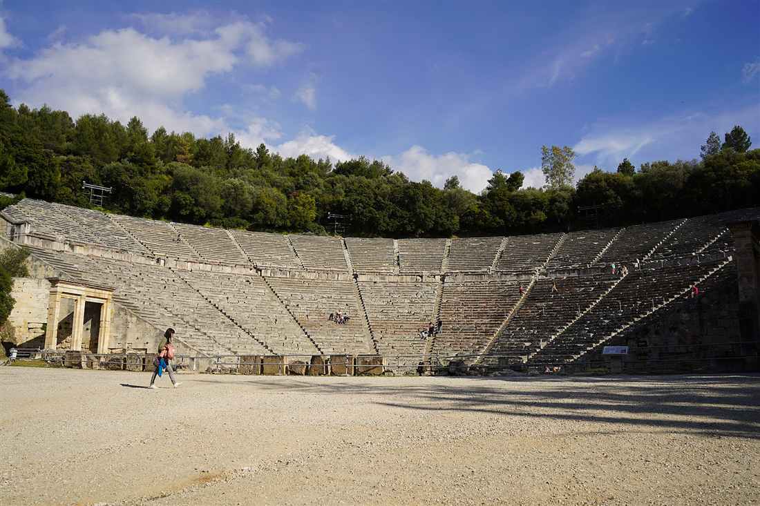
Peloponnese tours at Epidaurus show the ancient theatre built by Polykleitos the Younger in the late 4th century BC, with seats for up to 14,000 people, and the sanctuary of Asclepius, the most celebrated healing centre of the ancient world. Both joined the UNESCO list in 1988.
The theatre stands on the west side of Mount Cynortion, near the modern town of Lygourio. It was built between about 340 and 300 BC. Pausanias praised it for its symmetry and beauty. It holds the three parts of a Hellenistic theatre: the seating, the orchestra and the stage building. The Romans did not alter it, so it keeps its original form.
The original 34 rows were extended in Roman times by another 21 rows. A walkway 1.82 metres wide divides the lower and upper seating. The lower part has 12 sections and the upper part 22. The front rows of both parts were reserved for important guests. The round orchestra measures 20 metres across. A drain ring runs around its edge.
The theatre is known for its acoustics. Tour leaders on Peloponnese tours drop a coin or strike a match in the centre of the orchestra, and visitors in the upper rows hear it. The design uses three centres of curvature, which gives both clear sound and clear views.
Epidaurus stayed independent of Argos until Roman times. With its land it formed the small territory of Epidauria. Strabo wrote that the Carians called the city Epikaros and the Ionians called it Epitauros. The Dorians gave it the name Epidauros. Two modern villages keep the name, and the seat of the municipality is Lygourio.
What was the sanctuary of Asclepius?
Asclepius was the healer god of the ancient world. Tradition made Epidaurus his birthplace. His cult here is recorded from the 6th century BC, when the older hill-top sanctuary of Apollo Maleatas grew too small for the pilgrims. Sick people came from across the Greek world. They slept one night in a great hall, the enkoimeteria. They believed the god revealed their cure to them in a dream. A guest house, the katagogion, held 160 rooms.
The sanctuary thrived until Sulla sacked it in the 1st century BC. It revived after a visit by the emperor Hadrian in AD 124. The Goths raided it in AD 395. It still worked as a Christian healing centre in the 5th century. Peloponnese tours walk from the theatre past the stadium, the banqueting hall and the palaestra to the temple foundations. The site museum shows inscriptions of the cures.
Which Peloponnese tours include a performance?
The theatre still hosts ancient drama. The first modern performance was Sophocles’ Electra in 1938, with Katina Paxinou. The Epidaurus Festival has run as an annual event since 1955, in the summer months. Maria Callas sang Norma here in 1960 and Medea in 1961. Evening Peloponnese tours from Athens and Nafplio take audiences to festival nights. Our page on the Epidaurus day trip from Athens covers the daytime visit.
The name Epidaurus also belongs to two coastal villages, Palaia and Nea Epidavros, on the Saronic Gulf. The sanctuary lies about 8 km inland from the ancient town. Peloponnese tours reach it from Nafplio on the road through Lygourio.
What do Peloponnese tours show at Ancient Olympia?
Peloponnese tours at Ancient Olympia show the Altis, the sacred grove of Zeus, where the Olympic Games were held every four years from the 8th century BC to the 4th century AD. The visit covers the Temple of Zeus, the stadium, the Pelopion and the Archaeological Museum.
Olympia lies in the valley of the Alfeios river in Elis, in the west of the Peloponnese. The Kladeos river forms the western edge of the site. The sea of the Gulf of Kyparissia lies 18 km away. The site held more than 760 significant buildings. Pausanias counted over 70 temples, along with treasuries, altars and statues. Olympia was inscribed as a UNESCO World Heritage site in 1989.
The stadium is the part that visitors remember. Athletes entered it through a vaulted tunnel. Spectators sat on the grass slopes along both sides. The length of its track became the stadion, the Greek unit of distance. Peloponnese tours walk through the tunnel and stand on the original start and finish lines. The first major games here took place in the 8th century BC.
What was the Temple of Zeus?
The Temple of Zeus was built between about 472 and 456 BC. It was the model of the classical Doric temple, with six columns across its fronts and thirteen along each side. Pausanias gave its height as 20.7 metres, its width as 29 metres and its length as 70.1 metres. Its roof tiles were of thin Pentelic marble. Along the roof ran 102 lion-head waterspouts, and 39 of them survive.
The east pediment showed the chariot race between Pelops and Oenomaus. The west pediment showed the battle of the Lapiths and the Centaurs. The metopes showed the Twelve Labours of Heracles. Inside stood the gold and ivory statue of Zeus by Phidias. It stood about 13 metres high and was one of the Seven Wonders of the Ancient World. Our page on the Temple of Zeus at Olympia covers the temple.
What do Peloponnese tours see in the Olympia museums?
The Archaeological Museum of Olympia shows finds from prehistory to the Roman period. Its main pieces are the Hermes of Praxiteles, the sculptures of the Temple of Zeus, the Nike of Paionios and a jug that belonged to Phidias. Its bronze collection is one of the most important in the world. The first museum here opened in 1888. It was the first Greek museum built outside Athens. That older building now houses a museum of the history of the ancient Olympic Games. Our page on the Archaeological Museum of Olympia covers the collection.
The Pelopion is the tomb of Pelops, the hero who gave the Peloponnese its name. The flame for the modern Olympic Games is lit at Olympia before each Games. Peloponnese tours that stay in the village also visit the workshop of Phidias, the Philippeion and the row of treasuries of the city-states.
Which Peloponnese tours start from Olympia?
Olympia lay inside the independent state of Elis, and the Eleans ran the games. The Olympic truce guaranteed safe passage for athletes and visitors travelling to the festival. Olympia serves today as a base for the west. A walking tour with a professional licence holder and a tour led by an Italian-Greek archaeologist run on the site. A private tour links Olympia with the Temple of Apollo Epicurius at Bassae. A day tour runs from Olympia to Kalavryta, its monasteries and its cog railway. Cooking classes, tavern lunches and olive oil factory visits run in the countryside around the village.
Bassae stands at 1,131 metres on Mount Cotylion, 6 km south of the village of Andritsaina. Its temple was built between 450 and 400 BC. It is one of the best preserved temples of Greece. Its interior holds one of the earliest known Corinthian columns, and it was the first temple with a continuous frieze inside the cella. Our page on the Temple of Apollo Epicurius at Bassae covers the site. North of Olympia, the Frankish castle of Chlemoutsi was built between 1220 and 1223, on a plateau 226 metres above sea level.
Which Peloponnese tours reach Sparta, Mystras and Monemvasia?
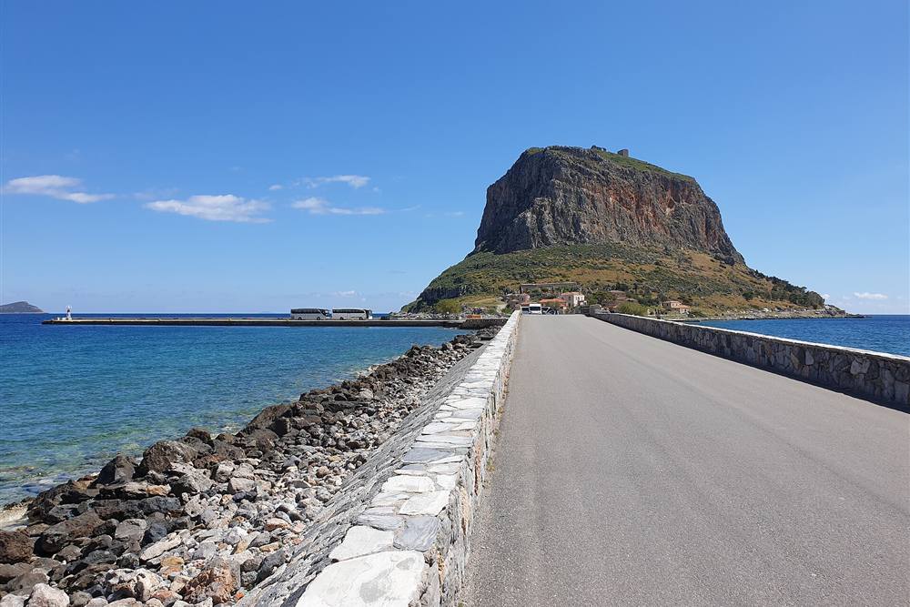
Peloponnese tours in Laconia visit Sparta in the Evrotas valley, the Byzantine ghost town of Mystras on the slope of Taygetus, and Monemvasia, a walled town on a rock joined to the coast by a 400-metre causeway. Mystras joined the UNESCO list in 1989.
Sparta was the leading land power of classical Greece. In ancient times the state was called Lacedaemon. Its capital was a group of villages in the valley of the Evrotas. In the 6th century BC Sparta founded the Peloponnesian League. Its army fought at Thermopylae under Leonidas and at Plataea under Pausanias. It won the Peloponnesian War against Athens in 404 BC. Its power ended with the defeat at Leuctra in 371 BC.
The modern town of Sparta was built in the 1830s. It is the seat of the regional unit of Laconia. The ruins of the ancient city lie on its northern edge. Peloponnese tours from Kalamata cross Taygetus on National Road 82 to reach it. “From Kalamata: Mystras and Sparta Day Trip” and a private day trip from Kalamata to Sparta cover this crossing.
What do Peloponnese tours see at Mystras?
Mystras stands on a spur of Mount Taygetus, 8 km west of modern Sparta. In 1249 the Frankish prince William II of Villehardouin built a fortress on the hill. The town below it became the capital of the Byzantine Despotate of the Morea in the 14th and 15th centuries. Artists, architects and scholars such as Gemistos Plethon worked here. Constantine XI Palaiologos, the last Byzantine emperor, was despot of Mystras before he took the throne in Constantinople.
The town was abandoned in the 1830s, when the new Sparta was built. Its streets climb the slope as stepped footpaths. Peloponnese tours walk from the lower gate past the churches to the Palace of the Despots, a three-storey building with an audience hall on the top floor. The frescoes of the churches survive, and the Hagia Sophia church keeps part of them. The Frangopoulos House and the Laskaris House show how nobles lived in the 15th century. Our page on Mystras tours covers the site.
What do Peloponnese tours see at Monemvasia?
Monemvasia is a town on a tied island off the east coast of Laconia. A sandy tombolo 400 metres long joins it to the mainland. The rock rises to a plateau 100 metres above the sea. The plateau is up to 300 metres wide and 1 km long. The name means “single entrance”, from the Greek words moni and emvasis. Visitors call it the Gibraltar of the East.
The town was founded in the 6th century. It is one of the oldest continually inhabited fortified towns in Europe. In the Middle Ages it was one of the main trading towns of the eastern Mediterranean. Its Italian name, Malvasia, gave its name to the Malmsey wine. The lower town keeps its walls, its stone houses and the church of Christ Elkomenos. A path climbs the cliff to the upper town and the church of Hagia Sophia at the top.
Peloponnese tours to Monemvasia stay the night in the lower town or in Gefyra, the modern village across the causeway. The “2-Day Private Tour Best of Peloponnese: Sparta & Monemvasia” combines the rock with Sparta and Mystras. Our page on the Monemvasia wine tasting covers the wineries of the area. On 27 June 2007, Monemvasia recorded a minimum temperature of 35.9 °C. That is the highest minimum temperature on record in mainland Greece and in continental Europe.
What do Peloponnese tours show in the Mani?
Peloponnese tours in the Mani show the stone tower houses of Areopoli and Vathia, the underground river of the Diros caves, the harbours of Limeni and Gerolimenas, and Cape Matapan, the southernmost point of mainland Greece. They start from Kalamata, Gytheio and Kardamyli.
The Mani is the middle of the three southern peninsulas of the Peloponnese. It is the southern end of the Taygetus range and runs about 45 km to the sea. Its interior is rocky and its coasts are steep. In ancient times it was part of Laconia, the land of Sparta. Today it is split between East Mani in Laconia and West Mani in Messenia. In 2003 the whole peninsula was declared a cultural complex of international importance.
The Mani was once called Maina Polypyrgos, a name taken from its tower houses. Clans built stone tower houses for defence in their feuds. From 1978 the Greek state listed the tower villages as traditional settlements and limited new building. Peloponnese tours of the Mani stop in these villages for their towers and their Byzantine chapels.
Which towns do Peloponnese tours visit in the Mani?
Areopoli means “city of Ares”. The War of Independence began here on 17 March 1821. Petros Mavromichalis, the last bey of the Mani, raised the first flag in Taxiarchon Square. The town lies 1.5 km above its port, Limeni, and 20 km south-west of Gytheio. A market fills the main square each Saturday. Vathia, further south, is a largely abandoned village of tall towers on a hill. Wildflowers cover its hills in spring. Gerolimenas, “Old Harbour”, was reached mainly by boat until the 1970s. It now has 88 residents.
Gytheio is the largest town of the Mani. It was the port of ancient Sparta, 40 km to the north. The islet of Cranae lies off its harbour and joins the town by a causeway. Myth says Paris and Helen spent their first night there before they sailed to Troy. The Tzannetakis Tower on the islet houses the historical and cultural museum of the Mani.
What are the Diros caves?
The Diros caves lie on Diros Bay, between Areopoli and Pyrgos Dirou. The bay holds three caves: Alepotrypa, Glyfada, also called Vlychada, and Katafygi. Visitors ride small boats through flooded halls of stalactites and stalagmites. Research shows people used the caves for worship in the Palaeolithic and Neolithic ages. They believed the caves led to the underworld. Our page on the Diros caves covers the visit.
“Kalamata: Full day Diros Caves & Limeni Dinner Tour” joins the caves with a dinner in the bay of Limeni. “Peloponnese: 5-hour tour exploring Mani” runs a shorter loop of the villages. The Apidima Cave on the west coast yielded Neanderthal fossils, and the Monastery of Panagia Yiatrissa stands on the ridge above Gytheio.
Why do Peloponnese tours drive to Cape Matapan?
Cape Matapan, also called Tainaron, is the southernmost point of mainland Greece. It is the second southernmost point of mainland Europe. Legend placed the entrance to Hades in a cave near the cape. The ruins of a temple of Poseidon stand on the hill above. The Byzantines turned the temple into a church. A lighthouse built in 1892 stands at the tip, now out of use. A footpath leads to it from the end of the road.
Kardamyli, on the west coast, is one of the seven cities that Agamemnon offered to Achilles in the Iliad. It keeps its ancient name, a medieval castle and tower houses. The Viros Gorge, 20 km long, runs down to the village. The English writer Patrick Leigh Fermor lived at Kalamitsi, just outside Kardamyli. Paths from Kardamyli climb to the summit of Taygetus, Profitis Ilias. Peloponnese tours on foot use the village as their base in the west Mani.
Which Peloponnese tours climb into Arcadia and Kalavryta?
Mountain Peloponnese tours climb to the stone villages of Arcadia, Dimitsana and Stemnitsa, and hike the Lousios gorge with its cliff monasteries. In the north they ride the Diakopto–Kalavryta rack railway through the Vouraikos gorge to the Mega Spilaio monastery and the Cave of the Lakes.
Arcadia holds the high centre of the Peloponnese. Myth made it the home of the gods Hermes and Pan. In the art of the European Renaissance, its name came to stand for an unspoiled wilderness. Tripoli is its capital and the capital of the Peloponnese region. The municipality has 44,165 people. The plains of Tegea and Mantineia lie around the city.
What do Peloponnese tours see in Dimitsana and Stemnitsa?
Dimitsana is a stone village at 950 metres on a mountain slope. It is built on the site of the ancient town of Teuthis. In the War of Independence, 14 gunpowder mills worked here day and night. That earned it the name “the Nation’s powder keg”. Its library holds about 35,000 books, manuscripts and documents. The Open-air Water Power Museum, opened in 1997, shows a flour mill, a tannery and a gunpowder mill. Philosophou Monastery, founded in 963, lies 2.5 km away.
Stemnitsa lies 6 km south-east of Dimitsana at about 1,050 metres. From May to June 1821 it served as the first seat of the Peloponnesian Senate, the government of the freed Peloponnese. It was known for its gold and silver smiths, and a public school of the craft has run here since the 1970s. Its folklore museum shows a candle workshop, a jeweller’s shop and Byzantine icons.
What is the Lousios gorge?
The Lousios gorge runs about 15 km from Dimitsana south to Karytaina. It is about 2 km wide, with forests and steep cliffs. Its monasteries give it the name “Mount Athos of the Peloponnese”. The monastery of Timiou Prodromou hangs on the rock face 7 km from Stemnitsa. Philosophou, Aimyalon and Panagia Kalamiou also stand in the gorge. At its southern end lie the ruins of ancient Gortys and its temple of Asclepius. Peloponnese tours on foot walk the gorge between the monasteries.
Karytaina stands on a hill above the Alfeios. The Frankish baron Geoffrey of Briel built its castle in the 13th century. Andritsaina, to the west, keeps a fountain built in 1724, the oldest in the Peloponnese. Its Nikolopouleios library holds more than 40,000 volumes. Megalopolis, to the south, had an ancient theatre for 20,000 spectators, one of the largest in Greece.
What do Peloponnese tours see at Kalavryta?
Kalavryta lies in the mountains of Achaea, 40 km south-east of Patras. The Diakopto–Kalavryta railway climbs to it from the Gulf of Corinth. The line runs 22 km on a 750 mm gauge. It opened in 1896 and is the steepest railway in Greece. On three stretches, where the gradient passes 10 percent, a toothed rack in the centre of the track pulls the train. The line passes through tunnels and over bridges in the Vouraikos gorge.
The train stops at Zachlorou for the monastery of Mega Spilaio, the “Great Cave”. The monastery sits in a cave in a cliff 120 metres high, as an eight-storey building. Tradition dates its founding to 362. Agia Lavra monastery lies 4 km south-west of Kalavryta. There, on 25 March 1821, Bishop Germanos raised the flag of the revolution. The Cave of the Lakes lies 17 km from Kalavryta, near Kastria. In summer it holds 13 lakes on three levels. In winter the melting snow turns the cave into a flowing river with waterfalls. Fossil bones of hippopotamus and other animals have been found on its lower level.
Kalavryta also carries a darker memory. On 13 December 1943, German troops killed the men and boys of the town in the Kalavryta massacre. A memorial stands on the hill where it happened. Peloponnese tours to Kalavryta visit the memorial and the museum of the massacre.
What do Peloponnese tours show in Messinia?
Peloponnese tours in Messinia show Kalamata, the ruins of Ancient Messene, Navarino Bay at Pylos, the Palace of Nestor, the omega-shaped beach of Voidokilia and the Venetian castles of Methoni and Koroni. Kalamata airport and cruise port serve as the starting points.
Kalamata is the second city of the Peloponnese after Patras. The city proper has 58,816 people. It lies at the head of the Messenian Gulf, on the Nedon river. It is the home of the Kalamatianos dance, the Kalamata olive and Kalamata olive oil. Walking Peloponnese tours cover the old town below the castle, the Church of the Holy Apostles and the waterfront. Our page on Kalamata tours covers the routes that start in the city.
What do Peloponnese tours see at Ancient Messene?
Ancient Messene lies 25 km north of Kalamata and 60 km east of Pylos. The Theban general Epaminondas founded the city in 369 BC, after he defeated Sparta at Leuctra. He invited the Messenians back after centuries under Spartan rule. The walls, the stadium, the theatre and the sanctuary of Asclepius survive. A museum stands inside the city walls. The site won a Europa Nostra award in 2011. “Timeless Ancient Messene: A Journey Through History” runs from Kalamata. Our page on the Ancient Messene tour covers the site.
What happened at Navarino Bay?
Pylos, also called Navarino, is the main harbour on Navarino Bay. The Battle of Navarino was fought in the bay on 20 October 1827. British, French and Russian fleets destroyed the Ottoman and Egyptian fleet. It was the last major naval battle fought entirely with sailing ships. The victory made Greek independence far more certain. The new town of Pylos was built from 1829 by the French engineers of the Morea expedition.
Two castles guard the bay. The Franks built Old Navarino in the 1280s on the cape above Voidokilia. The Ottomans built New Navarino, the Niokastro, above the town in 1571–1572. Boat Peloponnese tours from Pylos sail around the island of Sphacteria, which closes the bay. “Navarino Bay: Sea Kayaking with Lunch” paddles the same waters. Our page on Pylos and Navarino Bay covers the town and the bay.
What is the Palace of Nestor?
The Palace of Nestor is the best-preserved Mycenaean palace yet found. It stands on the hill of Epano Englianos, 17 km north of Pylos and 4 km south of Chora. Homer placed King Nestor in “sandy Pylos”. The palace had two storeys, store rooms, workshops, baths and a drain system. It burned around 1250 BC. In 1939 the excavators found about 1,000 Linear B clay tablets there. In 1952 Michael Ventris showed that the tablets were written in an early form of Greek. A new roof with raised walkways opened in 2016. In 2015 a team from the University of Cincinnati found the tomb of the “Griffin Warrior” nearby.
Why do Peloponnese tours stop at Voidokilia?
Voidokilia is a beach in the shape of the Greek letter omega. A strip of dunes separates it from the Gialova Lagoon. Tradition makes it the place where Telemachus met Nestor in the Odyssey. Nestor’s Cave lies above its southern end. Myth says Hermes hid the cattle he stole from Apollo there. The lagoon is a Natura 2000 area. It hosts 258 species of birds, 79 of them in the Red Book of threatened species, and the African chameleon. “Mystical Messinia: Voidokilia, Pylos & Methoni Wonders” covers the beach, the town and the castle in one day.
What do Peloponnese tours see at Methoni and Koroni?
Methoni castle covers the whole of its cape. A stone bridge of 14 arches crosses its moat. Inside lie the ruins of Venetian houses, a Turkish bath and the church of Saint Sophia. A sea gate leads over a small bridge to the Bourtzi, an octagonal tower on an islet. Koroni sits on the Messenian Gulf, 56 km south-west of Kalamata, below its own Venetian castle. Venice called the two towns Modon and Coron, “the chief eyes of the Republic”. Our page on the Methoni and Koroni tour covers both castles. Kyparissia, 38 km north of Pylos, lies on the Gulf of Kyparissia, one of the main nesting grounds of the loggerhead sea turtle.
What food and wine do Peloponnese tours taste?
Food Peloponnese tours taste Kalamata olives and olive oil in the groves of Messinia, red Agiorgitiko wine in Nemea, white Moschofilero in Mantineia, sweet Mavrodaphne near Patras and Malvasia at Monemvasia. Cooking classes and tavern lunches run in Olympia, Kalamata and Nafplio.
The Kalamata olive is large, dark purple and almond-shaped. Its tree has leaves twice the size of other olive trees. The fruit cannot be picked green. It is picked by hand to avoid bruising. Within the European Union the name Kalamata is a protected designation of origin. It covers olives and olive oil from the region around Kalamata, which takes in Messenia and nearby Laconia. Olives of the same variety grown elsewhere sell as Kalamon. Producers cure them in two ways. The short method soaks them in water or weak brine for about a week, then packs them in brine and wine vinegar under a layer of oil. The long method keeps slit olives in strong brine for up to three months.
Olive oil Peloponnese tours walk the groves and the mills. “Kalamata: The Olive Oil Routes Tour” has more than 90 reviews. “Kalamata, Greece: Organic Olive Grove Tour-Olive oil tasting” visits a family grove. Near Olympia, a tour joins a tavern lunch with a visit to an olive oil factory. Our page on the Kalamata olive oil tasting covers the tastings.
Which wines do Peloponnese tours taste?
- Agiorgitiko, Nemea: the most widely planted red grape of Greece. It gives deep red, fruity, spicy wines. Local legend calls Nemea wine the “Blood of Hercules”.
- Moschofilero, Mantineia: a pink-skinned aromatic grape grown on the plateau near Tripoli. It is the grape of the Mantineia PDO white wines, with a rose-garden bouquet.
- Mavrodaphne, Patras: a black grape of Achaea and a sweet fortified wine. Gustav Clauss, founder of the Achaia Clauss winery, first produced it around 1850.
- Malvasia, Monemvasia: the sweet wine named after the Italian form of the town’s name.
- Messinia: “Messinia: Wine tasting at Psaroulis Wines” pours local wines in the vineyard.
Nemea is the most important red wine appellation of southern Greece. Its vineyards lie in a basin at about 300 metres, surrounded by hills. It is also the largest vineyard area in the Balkans. Wine Peloponnese tours from Athens reach it in a day. Our page on Nemea wine covers the grapes and the wineries.
Which food tours run in the towns?
“Kalamata Food Tour: Greek Food Treasures and Traditions” walks the market and the old town of Kalamata. Our page on the Kalamata food tour covers the stops. In the Argolid, food Peloponnese tours walk the lanes of Nafplio. Our page on the Nafplio food tour covers that route. A day tour from Athens to Olympia includes a cooking class and lunch in the countryside.
Leonidio, on the east coast of Arcadia, grows the Tsakonian eggplant. It is sweet, and the European Union protects its name. Every August the port of Plaka holds the Tsakonian Eggplant Festival, with chefs from across Europe. Peloponnese tours on the east coast also taste citrus fruit, pears and tomatoes from the plain of Leonidio.
Which outdoor Peloponnese tours run on land and sea?
Outdoor Peloponnese tours include sea kayaking in Navarino Bay and the Corinthian Gulf, canyoning at the Polylimnio waterfalls, snorkelling over sunken ruins, hiking in the Lousios, Viros and Neda gorges, rock climbing at Leonidio and skiing on Mount Chelmos.
Sea kayaking runs in three places. “Navarino Bay: Sea Kayaking with Lunch” paddles the bay of the 1827 battle. A Corinthian Gulf sea kayaking tour from Athens explores the sea caves of the gulf coast. “Loutraki Sea Kayak: From Lake to Sea” starts on Lake Vouliagmeni and paddles out into the gulf. Sea Peloponnese tours of this kind start in the morning, when the water is calm.
“Kalamata: Polylimnio Waterfalls Canyoning Adventure” runs in Messinia. The name Polylimnio refers to the chain of waterfalls and pools in its ravine. Our page on the Polylimnio waterfalls covers the site. “Ancient Corinth, Mycenae & snorkelling in sunken city” joins two ancient sites with a swim over submerged ruins.
Where do walking Peloponnese tours hike?
- Lousios gorge: 15 km of forest paths between cliff monasteries, from Dimitsana to ancient Gortys.
- Viros gorge: 20 km from the slopes of Taygetus down to Kardamyli. It is dry in summer and floods in winter.
- Taygetus summit: Profitis Ilias, the highest point of the Peloponnese, from Kardamyli or from the eastern slopes.
- E4 path: the European long-distance path runs from Profitis Ilias past the monastery of Panagia Yiatrissa to Gytheio.
- Voidokilia to Old Navarino: a short climb from the beach to Nestor’s Cave and the Frankish castle.
- Neda gorge: the only river in Greece with a female name. It runs 31 km, with a waterfall near the village of Platania.
Spring and autumn suit walking Peloponnese tours. Snow stays on Profitis Ilias until early June. In summer, temperatures at Kardamyli range around 32–35 °C.
Which Peloponnese tours climb, ski or watch birds?
Leonidio has become a known destination for rock climbing. The town lies between two steep mountain sides, with the Parnon range behind. The area also has the Peleta sinkhole and the Propantes pothole. Mount Chelmos, 2,355 metres high, has a ski centre east of Kalavryta. The mountain also holds the Aristarchos telescope. The butterfly called the Chelmos blue flies on its slopes between 1,100 and 1,800 metres. Pine forest covers the mountain from 800 to 1,800 metres, with grass and bare rock above. Its highest peak, Psili Koryfi, reaches 2,355 metres. The villages of Planitero and Peristera sit on its slopes.
Bird-watching Peloponnese tours head for the Gialova Lagoon near Pylos and the southern Mani. The lagoon is a stop for migrating birds between Africa and northern Europe. The southern Mani is a Special Protection Area for 72 bird species, including Bonelli’s eagle and the lanner falcon. Our page on Kaiafas lake covers another wetland on the west coast.
Which Peloponnese tours add islands and the coast?
Coastal Peloponnese tours add the Argo-Saronic islands of Hydra, Spetses and Poros from Porto Cheli and Ermioni, the sand beaches of Elafonisos, the sunken city of Pavlopetri, and catamaran cruises from Kalamata. Kythira lies off the southern tip.
Two groups of islands lie off the Peloponnese coast. The Argo-Saronic islands lie to the east, and the Ionian islands lie to the west. Kythira, south of the peninsula, counts as one of the Ionian Islands. Peloponnese tours on the east coast of the Argolid reach the Argo-Saronic islands by short ferry crossings.
Which islands lie off the Argolid?
Porto Cheli is a summer resort on a bay of the Argolic Gulf, 40 km south-east of Nafplio. Spetses lies 6 km to its south. Ferries link Porto Cheli with Spetses, Hydra, Poros, Ermioni and Piraeus. Its marina is a wintering port for yachts. Ermioni, 44 km south-east of Nafplio, faces the islands of Hydra and Dokos. In classical times Hermione was known for its shipbuilders and its purple dye. Our pages on Spetses and Hydra cover the two islands, and our page on the Porto Cheli yacht charter covers boats from the resort.
Closer to Nafplio, Tolo has a long sand beach on the Argolic Gulf. Our page on Tolo covers the village. Peloponnese tours based in Nafplio add a beach afternoon at Tolo or a boat trip in the gulf.
What do Peloponnese tours see at Elafonisos and Pavlopetri?
Elafonisos is a small island between the Peloponnese and Kythira, with an area of 19 square kilometres. It lies 6.5 km from Neapoli on the mainland. Its beaches of Simos, Sarakiniko and Panagias Nissia have light sand and blue-green water. In July and August more than 3,000 visitors a day cross to it. The church of Agios Spyridon stands on a tiny islet joined to the island by a bridge. In antiquity Elafonisos was a peninsula. The earthquake of AD 365 cut it off from the mainland.
Pavlopetri lies in the shallow water of Vatika Bay, off the coast facing Elafonisos. It is about 5,000 years old and the oldest submerged city known. At least 15 buildings lie in 3 to 4 metres of water, with streets and tombs. The sea covered it around 1000 BC. Swimmers see its walls from the surface. Peloponnese tours on this coast stay in Neapoli or on Elafonisos.
Which coastal cruises run from Kalamata and Gytheio?
“Kalamata: Private or Shared Catamaran Cruise with Meal” sails the Messenian Gulf. It has more than 40 reviews. Our page on the Kalamata catamaran cruise covers the trip. From Gytheio, the islet of Cranae and its lighthouse of solid marble lie within walking distance of the port. Peloponnese tours on the coast of Laconia combine Gytheio with the beaches of the Laconian Gulf.
Across the Gulf of Corinth, Loutraki offers the Heraion of Perachora, a sanctuary of Hera at the tip of the Perachora peninsula. “Tour in Heraion (Sanctuary of Hera) and Lake Vouliagmeni” visits the sanctuary and the lake. Loutraki lies north-west of the Corinth Canal, on the mainland side of the cut.
Which Peloponnese tours suit cruise passengers?
Cruise passengers take Peloponnese tours from Katakolo to Ancient Olympia, 11 km from Pyrgos, and from Kalamata to Pylos and the Mani. Shore excursions fit the hours in port, with pickup at the ship and return before departure.
Katakolo is a seaside village on a headland of western Elis. It is 11 km west of Pyrgos, and Pyrgos is 16 km west of Olympia. The port is a regular stop for cruise ships. “Katakolo Cruise Port: Roundtrip Transfer to Ancient Olympia” has more than 1,600 reviews. “Katakolo Port: Transfer to Ancient Olympia and VR Audio Tour” adds virtual reality glasses that rebuild the temples on screen. “Olympia: Shared Minibus Tour from Katakolon” runs a shared minibus with a tour of the site.
A railway station links Katakolo with Pyrgos and Olympia. The village itself has a lighthouse built in 1865 and a Museum of Ancient Greek Technology. Its market has more than sixty shops, cafés and restaurants. The ruins of the medieval castle of Pontikokastro stand on a hill north-east of the port. The sunken ancient city of Pheia lies near Agios Andreas, within walking distance of the port. Our pages on Katakolo port and Katakolo to Olympia cover the transfer.
The Katakolo headland separates the Gulf of Kyparissia from the open Ionian Sea. The village of Agios Andreas, north-west of the port, was the natural harbour of ancient Olympia. The Franks called the castle above the port Beauvoir. In the late 19th century, Pyrgos grew rich on raisins shipped out through Katakolo. Peloponnese tours from the ships reach the museum and the site of Olympia by road or by train.
Which Peloponnese tours leave Kalamata port?
“Pylos: Tour with Cruise Port Pickup” collects passengers at Kalamata port and drives to Pylos and Navarino Bay. A shore excursion from Kalamata also covers the Mani peninsula. A private day trip from Kalamata reaches the Palace of Nestor and Pylos. These Peloponnese tours return to the port before the ship sails.
Which private Peloponnese tours run from Athens?
Private Peloponnese tours use cars and vans with a driver. They follow the route of the group, not a fixed coach timetable. “Visit Ancient Corinth Mycenae Nafplio Canal Luxury Tour 8H” covers four stops in eight hours. “Athens: Private Corinth Canal and Mycenae Tour” covers two. A customizable private van tour to Mycenae and Nafplio also runs from Athens. Private Peloponnese tours also collect passengers from Piraeus, the cruise port of Athens.
Patras has its own port and its own city tours. It is the third-largest city of Greece and lies 215 km west of Athens. It is the traditional place of the martyrdom of Saint Andrew. Its carnival in February is one of the largest in Europe. Patras was a European Capital of Culture in 2006. Our page on the Patras city tour covers the walk through the city.
How do you plan Peloponnese tours: seasons, roads and airports?
Plan Peloponnese tours for spring or autumn, when the sites are cooler, or for summer, when the Epidaurus Festival runs. Visitors from abroad arrive through Athens and cross the Corinth Canal by road. Kalamata airport serves the south-west in summer, and the Rio–Antirrio bridge links the north-west.
The Peloponnese has a hot-summer Mediterranean climate. The Gulf of Corinth is drier still. Rainfall is higher on the west coast, and the east of the peninsula is much drier. In the Evrotas valley, summer highs at Sparta pass 36 °C. The Taygetus peaks keep snow until early June. The Kardamyli coast lies in the lee of the mountains, and its sea is calm in the mornings.
Which season suits which Peloponnese tours?
- Spring: wildflowers around Vathia in the Mani and green forest in the Lousios gorge.
- Summer: the Epidaurus Festival, swimming at Voidokilia and Elafonisos, the Tsakonian Eggplant Festival in August.
- Autumn: the grape harvest in Nemea after mid-September, warm sea and cooler walking.
- Winter: skiing on Chelmos, the rack railway to Kalavryta, the carnival of Patras in February.
How do Peloponnese tours travel by road?
The Olympia Odos motorway runs from Athens to Corinth and on to Patras. The A7 motorway, also called the Moreas Motorway, starts just west of the Isthmus of Corinth. It runs 74 km from Corinth to Tripoli and 147 km from Corinth to Kalamata. A branch runs 45.5 km from Lefktro to Sparta. The whole network is 205 km long. Before it opened, the only road from Corinth to Tripoli ran through Nemea and Argos, with sharp bends.
The Rio–Antirrio bridge crosses the strait between the Gulf of Corinth and the Gulf of Patras. It is 2,380 metres long. It was inaugurated on 7 August 2004, a week before the Athens Olympic Games, and Olympic torchbearers were the first to cross it. Peloponnese tours that continue to Delphi and Meteora cross this bridge.
Which airports and ports serve Peloponnese tours?
Kalamata International Airport lies between Kalamata and Messini. It receives flights mainly in summer. Its runway is about 2.7 km long. The airport opened in 1959. Charter flights began in 1986, and a new terminal opened in 1991. Buses reach Kalamata in 20 to 25 minutes. The airport lies on the plain of the Pamisos river, beside the road that links Pylos, Kalamata and Sparta. Athens International Airport serves the rest of the peninsula by road. The Athens Airport–Patras railway runs along the Gulf of Corinth. It meets the rack railway at Diakopto, 2 hours 10 minutes from Athens.
The port of Patras links the Peloponnese with Italy and western Europe. Ferries from Piraeus reach Ermioni and Porto Cheli. Cruise ships call at Katakolo and Kalamata. Tripoli, at the junction of the A7 and its branches, sits at the centre of every road route across the peninsula. Our page on the best time to visit Olympia covers the seasons at the main site of the west.
Frequently Asked Questions
How far is the Peloponnese from Athens?
The Corinth Canal, the gateway to the Peloponnese, lies about 80 km west of Athens. Mycenae lies about 120 km from Athens, Patras 215 km and Ancient Olympia about 300 km by road.
Can you see the Peloponnese on a day trip from Athens?
Yes, in part. One-day Peloponnese tours from Athens cover the Corinth Canal, Mycenae, Epidaurus and Nafplio, or Ancient Olympia on its own. Sparta, Monemvasia, the Mani and Messinia need two days or more.
How many days do Peloponnese tours need?
Two days cover the Argolid, or Sparta with Monemvasia. Three or four days add Olympia, or Delphi and Meteora. A full circuit with the Mani, Messinia and the villages of Arcadia takes a week or more.
Which UNESCO sites do Peloponnese tours visit?
Mycenae and Tiryns, the theatre and sanctuary of Epidaurus, Olympia, Mystras and the Temple of Apollo Epicurius at Bassae. Bassae was the first Greek site on the World Heritage list, in 1986.
Which towns make the best bases for Peloponnese tours?
Nafplio for the Argolid, Ancient Olympia for the west, Kalamata for Messinia and the Mani, and Sparta or Monemvasia for Laconia. Dimitsana and Stemnitsa serve the mountains of Arcadia.
Do Peloponnese tours leave from cruise ports?
Yes. Shore excursions leave Katakolo for Ancient Olympia and Kalamata for Pylos and the Mani, with pickup at the ship and return before it sails.
Which airports serve Peloponnese tours?
Athens International Airport serves the whole peninsula by road. Kalamata International Airport serves Messinia and the Mani, with flights mainly in summer.
Why was the Peloponnese called the Morea?
Morea was its name from the late Middle Ages to the 19th century. The name Peloponnese means the island of Pelops, the mythical hero said to have conquered the region.
When does the Epidaurus Festival run?
In the summer months. The festival has staged ancient drama in the theatre of Epidaurus every year since 1955, and evening Peloponnese tours take audiences there from Athens and Nafplio.
What food do Peloponnese tours taste?
Kalamata olives and olive oil, red Agiorgitiko wine from Nemea, white Moschofilero from Mantineia, sweet Mavrodaphne from Patras and the Tsakonian eggplant of Leonidio.
What is the southernmost point of mainland Greece?
Cape Matapan, also called Tainaron, at the tip of the Mani peninsula. A footpath leads from the end of the road to its lighthouse, built in 1892.