
Mani tours cross the middle peninsula of the southern Peloponnese, a rib of grey limestone where clans built stone towers instead of houses. They take in Areopoli and the harbour of Limeni, the flooded galleries of the Diros caves, the tower village of Vathia, Cape Matapan at the southern tip of the mainland, Gytheio on the east coast and Kardamyli and Stoupa under Taygetus. Plan the rest of the trip with Greece Tours.
This page covers the Mani tours you can book from Kalamata, Kardamyli, Gytheio and Athens, what each part of the peninsula holds, the Byzantine churches and the towers, the gorges, beaches and sea trips, the food, and how the roads, the airport and the seasons shape the route.
What do Mani tours cover?
Mani tours cover the middle peninsula of the southern Peloponnese: the tower villages of Areopoli, Vathia and Kita, the Diros caves, the harbours of Limeni and Gerolimenas, Cape Matapan at the tip, and Kardamyli and Stoupa on the west coast. The Mani runs about 45 km to the sea.
The Mani is the central of the three peninsulas that reach south from the Peloponnese. It is the southern extension of the Taygetus range. The Laconian Gulf and Cape Malea lie to its east, and the Messenian Gulf and Messenia to its west. It ends at Cape Matapan, the southernmost point of mainland Greece. Its interior is rocky and rugged, and its coasts drop in cliffs and coves.
In ancient times the Mani counted as part of Laconia, the land of Sparta. Today two municipalities share it: East Mani in Laconia, with its seat at Gytheio, and West Mani in Messenia, with its seat at Kardamyli. Locals call the south Inner Mani and the north-west Outer Mani. In East Mani the western half of the Taygetus ridge carries the name Aposkiaderi, the shady side, and the eastern half Prodiliaki, the sunny side.
Why does the Mani look different from the rest of Greece?
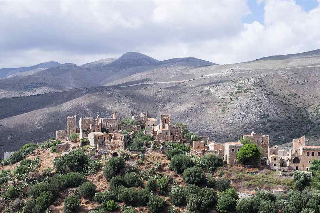
The peninsula was known as Maina Polypyrgos, the Mani of the towers. Clans built stone tower houses for defence in their feuds, and whole villages grew as clusters of towers. From 1978 the Greek state listed settlements with tower houses as traditional and limited new building. In 2003 the whole peninsula was declared a cultural complex of international importance. Mani tours drive between villages where every roofline is a tower.
The rock is Mesozoic limestone, and it erodes into karst caves such as Alepotrypa at Diros. Shallow soils cover the limestone, and red terra rossa fills the cultivated pockets. The south of the peninsula, about 317 square kilometres, is a Special Protection Area in the Natura 2000 network. It holds 72 bird species and is a route for migrating raptors, among them Bonelli’s eagle, the short-toed snake eagle, the lanner falcon and the eastern imperial eagle.
Which formats do Mani tours take?
- Day tours from Kalamata to the Diros caves, Limeni and Areopoli.
- Half-day village tours of five hours through Outer Mani and the towers.
- Two-day tours that cross the peninsula and come back by the other coast.
- Cave tours by boat through the flooded galleries at Diros.
- Walking tours in the Viros and Ridomo gorges and on the old paths between villages.
- Sea tours: kayaking from Kardamyli, self-drive boats from Kalogria and swims in the coves.
Our page on Peloponnese tours covers the wider peninsula, and our page on the Diros caves covers the cave visit in detail.
Which Mani tours run from Kalamata, Kardamyli and Gytheio?
Mani tours leave Kalamata for the Diros caves, Limeni and the villages, leave Kardamyli for Oitylo and the deep Mani, and leave Gytheio for Cape Matapan and the east coast. A shore excursion from Kalamata port covers the peninsula for cruise passengers.
Kalamata is the closest city with an airport and a cruise berth. “Kalamata: Full day Diros Caves & Limeni Dinner Tour” runs south along the west coast and ends with dinner by the water at Limeni. “Peloponesse: 5hour tour exploring Mani” covers the villages in half a day. “Kalamata Shore Excursion: Discover the Mani Peninsula” collects passengers at the port. “Kalamata: 2-Day Mani Peninsula Tour with Airport Transfer” adds a night in the south.
From Kardamyli, “Into the Wild Mani: Oitylo, Diros Caves & Limeni Charm” crosses the ridge and drops to the west-coast harbours. A private tour from Kalamata reaches Kardamyli, Stoupa and Agios Nikolaos in a day. Mani tours from Athens run as three-day private trips that take in Sparta, Mystras and the caves on the way.
How far apart are the towns on Mani tours?
- Kalamata to Kardamyli: about 35 km along the coast road under Taygetus.
- Kardamyli to Stoupa: about 10 km, with Agios Nikolaos 4 km beyond Stoupa.
- Stoupa to Oitylo: 32 km; to Limeni: 36 km; to Areopoli: 40 km.
- Areopoli to Limeni: 1.5 km down to the water.
- Areopoli to Pyrgos Dirou: about 26 km by the coast road.
- Areopoli to Gytheio: 20 km north-east across the neck of the peninsula.
- Gytheio to Sparta: 40 km north on National Road 39.
The roads are narrow and they climb, so Mani tours plan fewer stops than their distances suggest. Our page on Kalamata tours covers the trips that start in the city.
What do Mani tours show in Areopoli, Limeni and Oitylo?
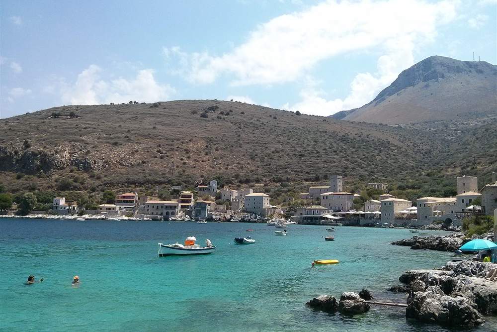
Mani tours in Areopoli show the stone town where the War of Independence began on 17 March 1821, its tower houses and its Saturday market. Limeni, its port 1.5 km below, holds a turquoise bay with stone houses at the water. Oitylo, above them, was the chief town of the Mani in the Middle Ages.
Areopoli means “city of Ares”, the god of war, and it took that official name in 1912. Before then it was called Tsimova. Petros Mavromichalis, the last bey of the Mani, raised the first flag of the revolution in Taxiarchon Square. Its tower houses are built of field stone, and they stand apart from the blue and white of the islands. A lively open-air market fills the main square every Saturday, with producers from the villages around.
In June 1826 Ibrahim Pasha landed near Areopoli and was thrown back after a battle at Diros. By 1829 the town held 290 families. Through the 19th and mid-20th centuries its population moved between 1,100 and 2,000. It remained the largest settlement of the peninsula. Mani tours use it as the hub of the south, because the roads to Diros, Gerolimenas and Gytheio all meet here.
Limeni sits on a narrow inlet below the town. Stone houses and towers stand at the edge of clear green water, and tavernas put their tables on the rock. The Mavromichalis tower complex stands above the bay. Mani tours stop here for lunch or for the swim before the drive south.
What do Mani tours see at Oitylo?
Oitylo is one of the oldest settlements of the peninsula. Homer names it in the Iliad, as Oetylus in the kingdom of Menelaus. In the Middle Ages it grew into the most important town of the Mani, and only Skoutari rivalled it for the number of its pirates. Areopoli later took its place as the chief town of Laconian Mani. The village looks across the bay of Oitylo, with Neo Oitylo and its beach below.
The castle of Kelefa stands above Oitylo. The Ottomans built it in the 1670s to control the Mani, and Venice took it later. Its walls and bastions survive on the ridge. Mani tours climb to it for the view over both sides of the neck of the peninsula.
What do Mani tours see in the Diros caves?
Mani tours at Diros ride small boats through the flooded galleries of the Vlychada cave, under stalactites that reach the water. The bay holds three caves: Alepotrypa, Vlychada, also called Glyfada, and Katafygi. Pyrgos Dirou village lies about 26 km from Areopoli.
The caves open on the shore of Diros bay, between Areopoli and Pyrgos Dirou. Visitors board flat boats at the mouth of Vlychada and are rowed through halls of stalactites and stalagmites, then walk the last stretch on foot. The water is still and clear, and the temperature holds through the year, so Mani tours run to the caves in every season.
Alepotrypa, the “fox hole”, is the archaeological cave. It served for burial and cult in the Neolithic, and it is one of the largest burial sites found in Europe. Excavators recovered the remains of at least 170 people, and among them the two skeletons known as the embracing skeletons of Alepotrypa, from a burial of the 4th millennium BC. Early farmers also lived in the cave. Digs ran from 1978 to 2005, and the Diros Regional Project took up the survey afterwards.
The name Dirou is first recorded in 1336, as Iro, when the place belonged to Nikolaos Atsagioli near Tzimova. The village of Pyrgos appears in 1571. The Battle of Vergas was fought near Diros in 1824, and in June 1826 the Maniots beat the forces of Ibrahim Pasha on Diros beach. The settlement of Pyrgos Dirou keeps tower complexes of its own: the Sklavounakos complex at Petrovouni, of 1832, has a six-storey tower that ranks among the tallest in the Mani.
Along the same coast, the Apidima caves cut into the sea cliff. Five karst caves make up the complex, and they are reached only by boat today. Two hominin skulls came out of them, and one researcher group dates the older of the two to about 210,000 years ago and reads it as the oldest modern human found in Europe. Mani tours pass below the cliff on the boat trips from Limeni.
Which tower villages do Mani tours reach in the deep south?
Mani tours in the deep south reach Vathia, the tower village on its ridge above the sea, Kita with its fortified houses, Gerolimenas around a small harbour, and Porto Kagio in its round bay. These villages stand in the last 20 km before Cape Matapan.
Vathia is the photograph that stands for the whole peninsula. Its towers rise together on a bare hill, above terraces of stone and the open Messenian Gulf. The village emptied through the 20th century, and part of it was restored as a hotel by the national tourist organisation. The towers still crown the ridge, and the road from Areopoli to Cape Matapan runs below them.
Kita held the largest concentration of war towers in the Mani. Clan feuds here lasted for generations, and the last full feud was put down by the army in the 1870s. Nomia, Pyrgos, Ochia and Gardenitsa keep the same building pattern: a church of the Byzantine centuries, a cluster of towers and a threshing floor.
What do Mani tours find at Gerolimenas and Porto Kagio?
Gerolimenas is a small fishing harbour on the west coast, built around a sheltered inlet under a bare grey slope. It was founded in the 1870s as a trading port and it kept its stone warehouses. Tavernas sit on the quay, and swimmers use the rocks and the shingle beside them. Mani tours stop here for lunch at the water on the way south.
Porto Kagio lies on the east side of the tip, in a nearly circular bay. The name comes from the Venetian Porto Quaglio, the port of quails, because the birds crossed here on migration. A few tavernas and rooms stand on the sand. The path to Cape Matapan and the trail to the bay of Marmari start close by.
Between them, on the west, the coast runs through Mezapos, Cape Tigani with its Byzantine castle of Maini, and the chapel-studded slopes of the Cavo Grosso plateau. The churches of the deep Mani number in the hundreds. Ayios Ioannis at Kita, Ayios Spyridon at Kalogeros and Ayios Petros at Gardenitsa are cross-in-square buildings of the 10th to 12th centuries.
What do Mani tours do at Cape Matapan?
Mani tours walk the last stretch to Cape Matapan, the southernmost point of mainland Greece and of the Balkans. The path from Kokkinogia takes about 40 minutes each way to the lighthouse, past the ruins of a temple of Poseidon and a cave the ancients called an entrance to Hades.
Cape Matapan is also called Cape Tainaron. Only Cape Tarifa in Spain lies further south on the European mainland. The cape divides the Messenian Gulf from the Laconian Gulf, and the sea off it is open to both. The point carries a lighthouse of 1882, a stone tower on the rock.
The walk begins at the end of the road at Kokkinogia. It crosses the mosaic floor of a Roman building, passes the 12th-century chapel of Asomaton, built on the temple of Poseidon Tainarios, and follows a rough path over grey slabs to the light. The sanctuary held the right of asylum in antiquity, and the sea cave beside it was named as a gate of the underworld, where Heracles was said to have dragged out Cerberus.
The sanctuary of Poseidon at Tainaron was one of the great asylums of the Greek world. Spartan helots took refuge there, and when the Spartans dragged them out and killed them the Greeks read the earthquake of 464 BC as the god’s answer. A necromanteion, an oracle of the dead, stood beside it, and the bronze statues dedicated at the shrine were described by Pausanias. Marble quarries on the cape cut the black-and-white rosso antico that Rome shipped out for its floors.
In March 1941 the naval Battle of Cape Matapan was fought in these waters, and the Royal Navy sank three Italian heavy cruisers and two destroyers. Mani tours to the cape combine the walk with a swim at Porto Kagio or Marmari, where the water is clear and the beaches are small.
What do Mani tours see at Gytheio and the east coast?
Mani tours at Gytheio see a port town of tiled neoclassical houses on the Laconian Gulf, the islet of Kranai joined to it by a causeway, and the wreck of the Dimitrios on Valtaki beach. Gytheio stands 20 km from Areopoli and 40 km from Sparta.
Gytheio was the harbour of Sparta and later the port of the Free Laconians. Its houses climb the slope in tiers of ochre and pink, and the waterfront is a line of fish tavernas. On Kranai the Tzanetakis tower of 1829 holds the Museum of the Mani, with rooms on the towers, the travellers and the history of the peninsula. Paris and Helen were said to have spent their first night on the islet.
North of the town, Valtaki beach carries the rusted hull of the Dimitrios, run aground in 1981 and left on the sand. Mavrovouni, just south, is a long sand beach backed by dunes and one of the main loggerhead turtle nesting beaches of the Peloponnese. It suits swimming and windsurfing, and it lies 4 km from the town.
Gytheio keeps the remains of a small Roman theatre at the north end of the town, cut into the slope of Mount Larysion, and the ancient city lies partly under the sea in the harbour. Augustus made the port the head of the league of the Free Laconians, and it shipped the rosso antico marble of Cape Matapan and the murex dye of the gulf. The Tzanetakis tower on Kranai was raised by a Maniot chief in 1829, the year the revolution ended.
The east coast road runs south from Gytheio through Skoutari, Kotronas and Flomochori, with towers above small bays. The castle of Passavas stands on the ridge between Gytheio and Areopoli, built by the Frankish lord Jean de Neuilly in 1254. Mani tours that cross from east to west pass under it.
What do Mani tours see at Kardamyli, Stoupa and the west coast?
Mani tours on the west coast see Kardamyli and its Old Town of tower houses, Stoupa with the sand of Kalogria bay, and Agios Nikolaos around its fishing harbour. This is Outer Mani, greener than the south, with olive groves running up to Taygetus.
Kardamyli is named in the Iliad as one of the seven cities Agamemnon offered Achilles. It sits 35 km from Kalamata, under the wall of Taygetus, with the islet of Meropi off its shore. The Old Town, Ano Kardamyli, stands above the modern village: the fortified Mourtzinos complex, the 18th-century church of Agios Spyridon with its carved bell tower, and a paved path up to the chapel of Agia Sofia.
The writer Patrick Leigh Fermor built a house at Kalamitsi, just south of Kardamyli, and lived there from the 1960s. His book “Mani: Travels in the Southern Peloponnese” of 1958 made the peninsula known to English readers. The house passed to the Benaki Museum. Mani tours pass the gate on the coast path to Kalamitsi cove.
What do Mani tours find at Stoupa?
Stoupa lies about 10 km south of Kardamyli, and it grew into the busiest resort of the west coast. It has two sand beaches, Stoupa and Kalogria, both with shallow clear water. A cold freshwater spring rises in Kalogria bay and marks the sea with a band of cool water. Nikos Kazantzakis worked a lignite mine near Stoupa in 1917 with George Zorbas, and the man became the model for Zorba the Greek.
Agios Nikolaos, 4 km further south, keeps a working harbour with caiques and a row of tavernas on the quay. Above it, Agios Dimitrios and Trahila end the paved coast road. Inland, Kastania climbs a wooded ravine with the 12th-century church of Agios Petros and a tower complex, and Saidona and Milia sit on the terraces above. Our page on Kalamata catamaran cruises covers the sea route along this shore.
Which outdoor Mani tours run on foot and by sea?
Outdoor Mani tours walk the Viros and Ridomo gorges out of Kardamyli, follow the old stone paths between the villages of Outer Mani, kayak the coast from Kardamyli and Stoupa, and swim in the coves around Limeni and Gerolimenas.
The Viros gorge cuts down from the summit ridge of Taygetus to the sea at Kardamyli. A marked path runs up its bed to the monastery of Lykaki and the village of Exochori. The Ridomo gorge opens further north, above Kambos, and it is the deeper of the two. “Kardamyli: Hiking tour in Ridomo gorge, the Grand Canyon of Greece” takes walkers along its rim and floor.
The old kalderimia, the stone mule paths, still link the villages of the west: Kardamyli to Petrovouni and Agia Sofia, Stoupa to Kastania, Exochori to Tseria. Taygetus rises to 2,404 m at Profitis Ilias, and the ridge route starts inland at Anavryti. In the south the paths cross open limestone between the towers, with no shade at all.
Which sea tours run in the Mani?
- Sea kayaking from Kardamyli along the cliffs, with lunch on a beach reached only from the water.
- Self-drive boats from Stoupa and Agios Nikolaos to the coves under Taygetus.
- Boat trips from Limeni past the Apidima caves and the cliffs of Cavo Grosso.
- Swim stops at Kalogria, Delfinia, Foneas and Ritsa on the west coast.
- Turtle-nesting beaches at Mavrovouni and Selinitsa near Gytheio.
Foneas beach, 5 km south of Kardamyli, is a small pebble cove split by a rock, and it is the most photographed swim of the coast. Delfinia and Ritsa lie between Kardamyli and Stoupa, both pebble and both backed by pines.
What history do Mani tours tell?
Mani tours tell of a region that stayed outside the control of the Franks and the Ottomans, ran under its own clan chiefs and beys, began the Greek War of Independence at Areopoli on 17 March 1821, and threw back Ibrahim Pasha at Vergas and Diros in 1824 and 1826.
The Maniots trace themselves to the Spartans and the Free Laconians, the Eleutherolakones whose league of 24 towns Augustus recognised. Christianity came late here: the emperor Basil I had the inland Maniots baptised in the 9th century, while the people of the far south held to the old gods longest of any in Greece. The Byzantine churches of the peninsula, hundreds of them, date from that conversion onwards.
After 1204 the Franks built Passavas, Mystras and the Great Maini, but the mountains stayed with the local clans. Under Ottoman rule the Porte appointed a bey of the Mani from among the chiefs, and the last of them, Petros Mavromichalis, raised the flag of the revolution at Areopoli. Maniot fighters then fought at Valtetsi, Tripolitsa and Dervenakia.
The towers come out of that history. Land was scarce, families were ranked as Nyklian or not, and feuds between clans were fought by building higher than the neighbour and firing down. A truce was called at harvest, and priests and women carried the terms. Mani tours read that history in the heights of the towers. Vathia, Kita and Nomia keep whole streets of those towers. Our page on Mystras tours covers the Byzantine city on the other side of Taygetus.
What do Mani tours eat and drink?
Mani tours eat syglino, the pork cured with orange peel and smoked over sage, with siglinovoutyro lard, hard local cheeses and wild greens. Olive oil from the Koroneiki groves of Messenia, honey from the herbs of the limestone, and figs dried in the sun fill the rest of the table.
Syglino is the signature of the peninsula. Pork is salted, boiled with orange peel, smoked with sage and mountain herbs, then kept under lard. It goes into omelettes with potato, into pasta, and on the plate with cheese. Lalangia, strips of fried dough, come with it at breakfast and at festivals.
The olive is the crop of the Mani. Terraces of Koroneiki trees run from the sea to the ridge, and the west-coast groves around Kardamyli and Kampos press an oil of high polyphenol count. Kalamata olives grow north of the peninsula, in the Messenian plain. Mani tours from Kalamata add a mill visit and a tasting to the drive south. Our page on Kalamata olive oil tasting covers that stop.
- Syglino — orange-cured smoked pork, the dish to order first.
- Lalangia — fried dough strips, eaten with syglino or honey.
- Sfela — the hard, salty PDO cheese of Messenia and Laconia.
- Horta — wild greens boiled and dressed with oil and lemon.
- Fish — grilled at the quay in Gerolimenas, Gytheio and Agios Nikolaos.
- Thyme honey — from hives on the open limestone of the south.
Mani tours book the fish tavernas of Limeni and Gytheio, where the catch of the day is sold by weight. Our page on the Kalamata food tour covers the market and the producers of the city to the north.
Which mountain villages do Mani tours reach above the coast?
Mani tours climb from the west coast to Kambos, Proastio, Exochori, Kastania and Saidona, villages of stone houses, churches and olive terraces on the flank of Taygetus. Each stands between 200 m and 600 m above the sea, with the gorges cutting down past them.
Proastio sits above Kardamyli and carries the name “village of the priests” for the number of its churches. Nearly forty stand in and around it, and a dozen keep frescoes of the 12th and 13th centuries. Exochori, on the other side of the Viros gorge, holds the church of Agios Nikolaos and the cemetery where the ashes of Patrick Leigh Fermor’s friend Bruce Chatwin were buried.
Kambos lies north of Kardamyli on the road to Kalamata, above the mouth of the Ridomo gorge, with the Mycenaean tholos tomb at Malthi and a tower of the Kapetanakos clan. Kastania climbs a wooded ravine south of Stoupa, and it keeps the 12th-century church of Agios Petros, a Venetian-era tower and a square of plane trees. Saidona and Milia stand higher still, on terraces that look down the length of the gulf.
These villages hold the shade the deep south lacks. Water runs in the ravines, plane trees grow in the squares, and the temperature drops three to five degrees with the height. Mani tours in July and August use them for the middle of the day, then drop to the coast for the evening swim.
Which Byzantine churches do Mani tours visit?
Mani tours visit the Byzantine churches of the peninsula, which number more than 800. The Episkopi at Stavri, Agios Petros at Gardenitsa, Agitria near Mezapos, Taxiarches at Charouda and Agios Theodoros at Vamvaka carry cloisonne brickwork, carved marble screens and frescoes of the 10th to 13th centuries.
The Mani holds the densest concentration of medieval churches in Greece. Almost every village of the south keeps one, and many stand alone in the fields, locked, with the key at the nearest house. They are small, cross-in-square buildings of dressed stone, with a dome on a drum and brick courses set between the blocks in the cloisonne pattern.
Agios Theodoros at Vamvaka carries a dated inscription of 1075, one of the firmest dates in the group. The Taxiarches at Charouda keeps a carved marble templon and a painted interior. Agitria, near Mezapos on the Cavo Grosso plateau, stands white against the limestone above the sea. Episkopi at Stavri served as the cathedral of the bishops of Maini.
The frescoes follow the Byzantine programme: Christ Pantocrator in the dome, the Virgin in the apse, the great feasts on the vaults, and ranks of soldier saints on the walls. Later hands painted over earlier ones, and in churches such as Episkopi two or three layers survive. Mani tours with an archaeologist-guide open the locked churches and read the inscriptions.
Where do Mani tours see the region’s collections?
- Museum of the Mani, in the Tzanetakis tower on Kranai, Gytheio — the towers, the travellers, the feuds.
- Pikoulakis Tower Museum, Areopoli — the Byzantine religious art of the peninsula.
- Archaeological Museum of Gytheio, on the waterfront — finds from Laconian Mani.
- Neolithic Museum of Diros, at Pyrgos Dirou — the finds from the Alepotrypa cave.
- Mourtzinos tower complex, Old Kardamyli — a restored clan stronghold open to visitors.
Which beaches do Mani tours reach?
Mani tours reach Kalogria and Stoupa on the west coast, Foneas, Delfinia and Ritsa between Kardamyli and Stoupa, Mavrovouni and Valtaki near Gytheio, and the small bays of Marmari and Porto Kagio at the southern tip. The water is clear on every coast of the peninsula.
The west coast beaches sit under Taygetus and face the Messenian Gulf, so they take the afternoon sun and the sunset. Kalogria at Stoupa is a broad crescent of sand with shallow water and a cold spring at one end. Stoupa beach, next to it, is longer and lined with tavernas. Delfinia and Ritsa lie a few kilometres north, both pebble, both backed by pines. Mani tours time the west-coast swims for the late afternoon, when the sun is on the water.
Foneas is the cove that sums up the coast: a strip of white pebbles split by a tall rock, with water that drops fast to deep blue. Kalamitsi, below the Leigh Fermor house, and Ritsa at Kardamyli are within walking distance of the village. Further south the coast turns to cliff, and the swims are at Limeni, Neo Oitylo and the rocks at Gerolimenas.
On the east, Mavrovouni runs for 4 km of sand and dune south of Gytheio, and loggerhead turtles nest there. Valtaki, north of the town, is the beach with the wreck of the Dimitrios on it. Skoutari and Kotronas hold small sheltered bays on the Laconian Gulf, and Mani tours down the east coast stop at them between the tower villages. At the tip, Marmari has two sand beaches side by side, and Porto Kagio fills the head of its round bay.
Where do Mani tours stay?
Mani tours stay in restored tower houses and stone guesthouses. Areopoli and Limeni put the caves and the tower villages within half an hour, Kardamyli and Stoupa serve the gorges and the west-coast beaches, and Gytheio covers the east coast and the road to Sparta.
The restoration of tower houses turned the building stock of the peninsula into its lodging. Towers in Areopoli, Vathia, Kardamyli and Limeni have been rebuilt room by room, with thick walls, small windows and vaulted ceilings kept as they were. Limeni holds the highest concentration of them at the water’s edge.
Base choice follows the itinerary of the Mani tours booked. Two nights in Outer Mani, at Kardamyli or Stoupa, cover the gorges, the old paths and the beaches. Two nights in Inner Mani, at Areopoli or Limeni, cover Diros, the tower villages, Cape Matapan and the churches. Gytheio suits a night on the way in or out, with Sparta and Mystras 40 km north.
Villages in the deep south keep few rooms, and Vathia, Kita and Gerolimenas hold a handful each. Tavernas in the small places close out of season, so winter stays concentrate on Areopoli, Gytheio, Kardamyli and Stoupa, where the villages stay open year-round.
Which sites combine with Mani tours?
Mani tours combine with Sparta and Mystras 40 km north of Gytheio, Monemvasia on the next peninsula east, Ancient Messene and the castles of Methoni and Koroni to the west, and Kalamata with its market, its port and the Polylimnio waterfalls above it.
Mystras is the strongest pairing. The Byzantine city climbs a spur of Taygetus above Sparta, with palaces, churches and a Frankish castle on the summit, and it is 40 km from Gytheio. Two-day and three-day tours from Athens take Sparta and Mystras on the way to the Mani and return by the coast. Our page on Mystras tours covers that site.
Monemvasia sits on the next peninsula east, a fortified town on a rock joined to the shore by a causeway. The drive from Gytheio runs about 90 km around the Laconian Gulf. West of the Mani, Ancient Messene keeps a stadium, a theatre and a circuit of walls with the Arcadian Gate, and Methoni and Koroni hold Venetian sea castles at the tip of Messenia. Mani tours that start in Kalamata reach both castles in a day.
- Mystras — the Byzantine city, 40 km north of Gytheio.
- Sparta — the archaeological museum and the site of the ancient city.
- Monemvasia — the rock town, about 90 km east of Gytheio.
- Ancient Messene — the walls, the stadium and the Asklepieion, west of Kalamata.
- Methoni and Koroni — Venetian sea castles on the Messenian coast.
- Polylimnio — the chain of waterfalls and pools north-west of Kalamata.
Our pages on Ancient Messene, Methoni and Koroni and the Polylimnio waterfalls cover the Messenian side of the trip.
How do visitors plan Mani tours?
Visitors plan Mani tours around Kalamata airport, 35 km from Kardamyli, or a drive of about 3 hours from Athens to Gytheio. Two or three days cover the peninsula: one for Outer Mani and the gorges, one for Areopoli, Diros and the towers, one for Cape Matapan.
Kalamata International Airport is the nearest arrival point, with flights from Athens and from European cities in the warm months. Athens is about 280 km from Gytheio by the Corinth and Tripoli motorway and then National Road 39. Buses run from Athens to Kalamata and Sparta, and local KTEL services link Kalamata, Kardamyli, Areopoli and Gytheio, though they run few times a day.
A car or a driver-guide covers more. Roads are paved to Cape Matapan and along both coasts, and they are narrow, steep and full of blind bends south of Areopoli. Mani tours with a driver leave visitors free to look at the towers rather than the road.
When do Mani tours run best?
- April to June — the hills are green, the flowers are out, the sea warms through June.
- July and August — the hottest months, with no shade in the deep south; start early.
- September and October — warm sea, quiet villages, the olive harvest beginning.
- November to March — mild on the coast, rain on Taygetus, many tavernas closed.
Base choices split the peninsula. Kardamyli and Stoupa suit walkers and swimmers on the west. Areopoli and Limeni put the caves and the tower villages within half an hour. Gytheio serves the east coast and the drive to Sparta and Monemvasia. Our page on the Monemvasia day trip covers the rock town on the next peninsula east.
Frequently Asked Questions
Where is the Mani?
In the southern Peloponnese, the central of the three peninsulas that reach south from mainland Greece. It runs from Kalamata and Gytheio down to Cape Matapan, and the Taygetus range forms its spine.
How long do Mani tours take?
Five hours for a village tour out of Kalamata, a full day for the Diros caves with Limeni and Areopoli, and two or three days to cover both coasts, the deep south and Cape Matapan.
Why does the Mani have tower houses?
Land was scarce and clans fought over it, so each family built a stone tower and fired down on its neighbours. Villages such as Vathia, Kita and Nomia grew as clusters of those towers.
Which is the main town of the Mani?
Areopoli in Inner Mani, where the War of Independence began on 17 March 1821. Gytheio is the seat of East Mani, and Kardamyli the seat of West Mani.
What is inside the Diros caves?
Flooded galleries hung with stalactites, toured by small boat and then on foot. The Alepotrypa cave next to them held a Neolithic settlement and one of the largest burial sites found in Europe.
Is Cape Matapan the southernmost point of Greece?
It is the southernmost point of mainland Greece and of the Balkan peninsula. Gavdos, south of Crete, is the southernmost point of Greek territory.
How do Mani tours reach the peninsula?
By Kalamata International Airport, 35 km from Kardamyli, or by road from Athens, about 280 km to Gytheio through Corinth and Tripoli. KTEL buses link Kalamata, Kardamyli, Areopoli and Gytheio.
Which food do Mani tours try?
Syglino, pork cured with orange peel and smoked over sage, with lalangia fried dough, sfela cheese, wild greens, thyme honey and the olive oil of the Koroneiki groves.
When is the best time for Mani tours?
April to June and September to October. The hills are green in spring, the sea stays warm into October, and the deep south carries no shade in the heat of July and August.
Which beaches do Mani tours use?
Kalogria and Stoupa on the west coast, Foneas, Delfinia and Ritsa near Kardamyli, Mavrovouni and Valtaki near Gytheio, and Marmari and Porto Kagio at the tip.
Who wrote the book that made the Mani famous?
Patrick Leigh Fermor, in “Mani: Travels in the Southern Peloponnese” of 1958. He built a house at Kalamitsi near Kardamyli and lived there from the 1960s.
How many Byzantine churches stand in the Mani?
More than 800, the densest concentration in Greece. Agios Theodoros at Vamvaka carries a dated inscription of 1075, and Episkopi, Agitria and the Taxiarches at Charouda keep frescoes and carved marble screens.