
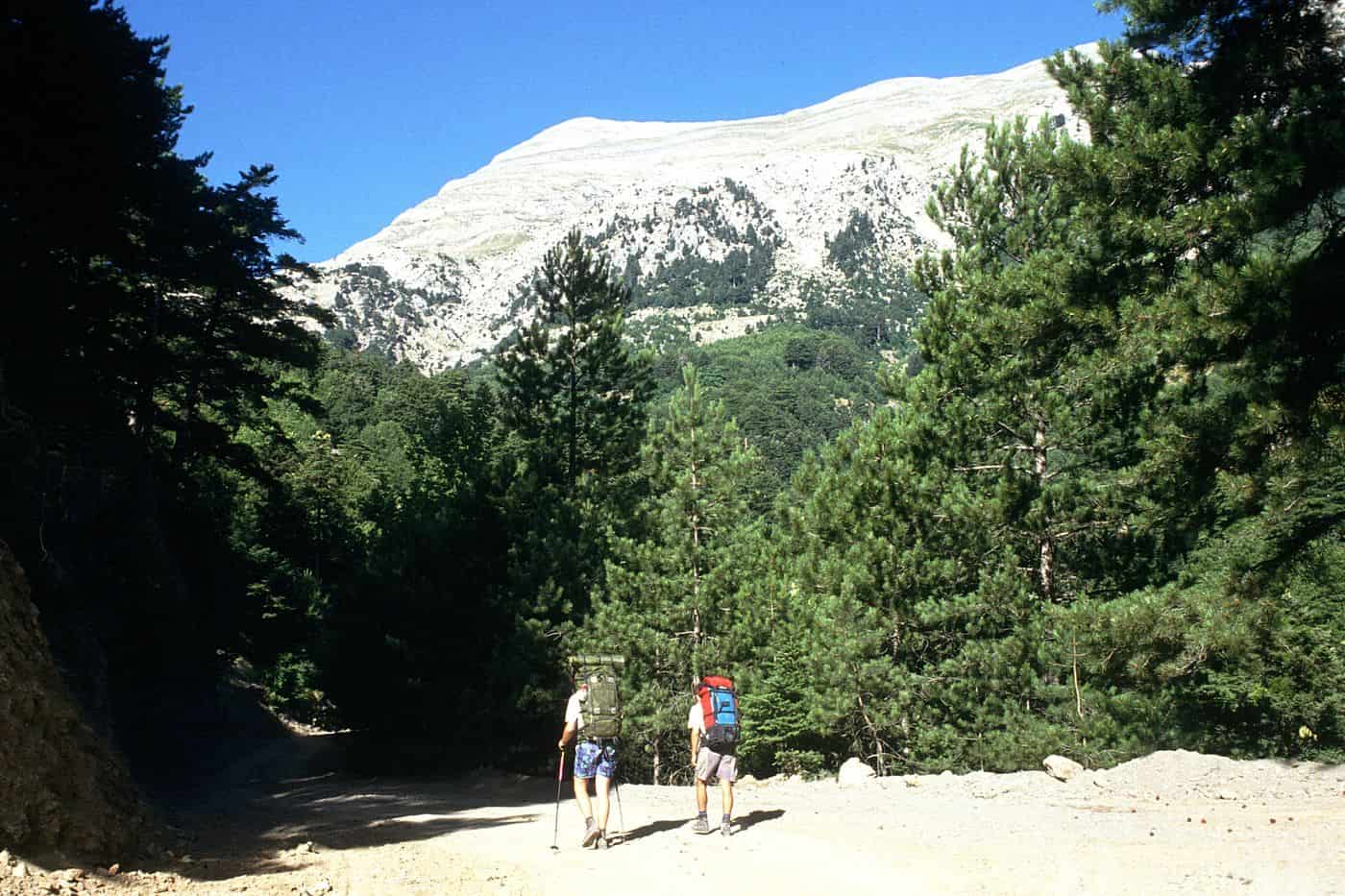
Kalamata hiking covers the marked trails, gorges and coastal paths within reach of Kalamata, from the slopes of Mount Taygetos and the Polylimnio waterfalls to the Ridomo and Viros gorges, the Mani coast and Navarino Bay. Guided hiking tours start from Kalamata. Greece Tours lists the tours that start in Greece.
This page covers each trail area, the guided tours, the seasons, difficulty, gear, how to reach the trailheads, river trekking and canyoning, and safety, with links to the rest of Kalamata tours. The tours below are checked on GetYourGuide and Viator.
What is Kalamata hiking like?
Kalamata hiking means mountain trails that leave the edge of the city for the Taygetos range, which dominates its skyline, plus gorges, cobbled mule paths and coastal walks in Messinia and the Mani. Local guides lead outings of 3 to 7 hours.
Kalamata hiking runs from sea-level beaches to the 2407-metre summit of Profitis Ilias. The plants change in belts on the way up: Mediterranean scrub on the lower slopes, then forests of black pine and Greek fir, then a subalpine zone of dwarf shrubs, and finally bare alpine ground with no trees below the summit.
Three kinds of ground make up Kalamata hiking. Old cobbled paths, built to link the higher villages with the lower ones, climb between olive groves and stone villages. Gorges such as Ridomo and Viros cut through limestone from the high peaks towards the sea. Coastal routes at Navarino Bay cross sand dunes and skirt a lagoon.
Which Kalamata hiking trails start from the city?
The closest Kalamata hiking trail to the city climbs Mount Kalathi, a peak of 1316 metres that rises above Kalamata. Guided groups start in Kato Verga or Ano Verga, southeast of the city, and walk old paths up to fir forest on the summit.
One version of this Kalamata hiking route starts low, in Kato Verga at 400 metres, and follows a cobbled path west to Ano Verga, a village of stone houses, narrow alleys and clear springs. Walnut, mulberry and chestnut trees surround the village, and old threshing floors just outside it serve as the picnic stop.
Above Ano Verga, the trail leaves the last terraces of orchards and pastures and rises smoothly into fir forest, past the ruins of a settlement from the last century. From the top, Kalamata hiking groups look over the Messinian Gulf, the city and the summits of central Taygetos. The guided outing lasts 4 hours including breaks.
Operators grade the climb as easy with challenging parts or as moderate, because the route rises from 400 metres to the summit. Children from 10 years old join the standard groups, so this Kalamata hiking day suits families as well as couples. Visitors who prefer the streets and squares below can book the Kalamata walking tour instead.
What is Kalamata hiking on Mount Taygetos like?
Kalamata hiking on Mount Taygetos means a guided day of 7 hours to Profitis Ilias, at 2407 metres the highest summit in the Peloponnese. The route starts from a refuge at 1550 metres, crosses alpine meadows and follows a ridge to the pyramid summit.
This Kalamata hiking day sets off from the refuge of the Sparta mountaineering club. The path climbs to alpine meadows of fragrant shrubs, wildflowers and an endemic herbal tea, then reaches Portes, meaning the gates, a split in the ridge that marks the start of the final stage.
The last stretch follows the Athanati Rachi, the immortal ridge, a crest above 2300 metres just north of the summit. At the top, Kalamata hiking groups find a small chapel and views east over the Evrotas valley and the Parnon range, and west over Kalamata and eastern Messinia.
Along the lower slopes of the range runs the E4 European long-distance path, which continues by way of Sparta to Gytheio. From the Messinian side, mountain paths leave Kardamyli and climb towards Profitis Ilias. The operator rates this Kalamata hiking summit day as challenging and takes children from 12 years old.
Which Kalamata hiking routes reach the Polylimnio waterfalls?
Kalamata hiking reaches the Polylimnio waterfalls on a gorge path that starts at the parking area near Haravgi village. The path passes a chain of blue lakes and falls, crosses small bridges and uses metal handholds, and the walk takes up to two hours.
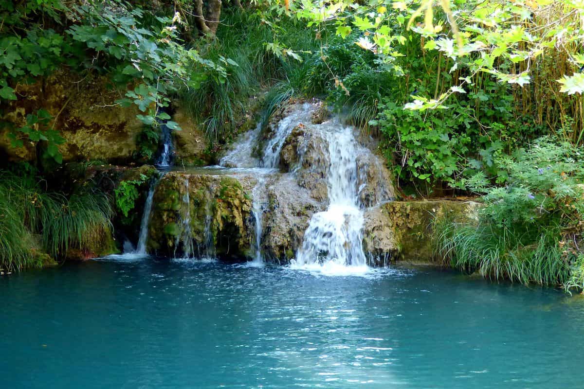
The name Polylimnio translates as “multiple lakes”, and the gorge matches it: water spills from one pool into the next on different levels, each one aqua blue. On a guided Kalamata hiking trip, the guide adds quieter lakes off the main path, where an optional swim under a waterfall rounds off the walk.
Guided Kalamata hiking trips start in Kalamata or at the gorge. One picks walkers up in the city for a short van ride and an outing of 3.5 hours with time to swim. The other meets at the Haravgi parking area, lasts 3 hours including breaks and ends with a picnic beside a lake.
The route has no significant height gain, so the operator grades it very easy and takes children from 8 years old, with a helmet included. That makes it the gentlest Kalamata hiking route on this page. Our page on the Polylimnio waterfalls covers the site itself.

Which Kalamata hiking routes follow the Ridomo and Viros gorges?
Kalamata hiking follows the Ridomo gorge, 10 km from the city, on a challenging route of 5 hours from the rim near Voreio village, and the Viros gorge, which runs 20 km from the foot of Profitis Ilias down to the sea at Kardamyli.
The Kalamata hiking route in Ridomo drops from the rim to the rocky bed and then works upstream, scrambling over huge boulders between limestone walls shaped by rushing water. Wild goats balance on the cliffs, ivy covers parts of the rock and small waterfalls drip from high above. After around 5 kilometres the boulders give way and the gorge narrows.
Beyond that point, the walk enters a corridor two metres wide between walls 60 metres high, narrow enough for walkers to nearly touch both sides. Ridomo, the longest gorge of Taygetos, runs from the high peaks down to Santova beach outside Kalamata. Kalamata hiking groups also join a small-group tour from Kardamyli or a guided hike to the Mana spring.
Kalamata hiking in the Viros gorge follows a deep river bed that stays dry in summer and floods in winter with snowmelt and heavy rain. Walking paths lead to nearby monasteries, the ancient royal road climbs through it, and endemic plants such as Lithodora zahnii grow there. Our Mani tours cover the wider peninsula.


Which Kalamata hiking routes follow the Mani coast?
Kalamata hiking along the Mani coast follows old paths between villages around Kardamyli, Stoupa and Exochori, where the Taygetos slopes meet the Messinian Gulf. Routes pass tower houses, chapels and olive groves on cobbled tracks, and the guided walks last 4 to 5 hours.
From the fort of old Kardamyli, the guided route follows the same royal road towards Sparta, under olive, pine and cypress trees, to villages with Byzantine churches, stone watchtowers and old fountains; the outing lasts 5 hours. Another Kalamata hiking trail above the old town passes near the tombs believed to belong to the Dioskouri. Our Kardamyli tours cover the village itself.
Further along the coast road, the village of Lefktro sits a ten-minute walk above Stoupa beach, and the fishing village of Agios Nikolaos lies 4 kilometres from Stoupa (see our Stoupa tours). Inland, the village of Exochori sits 500 metres up on the south-west flank of Taygetos and 8 kilometres from Kardamyli, and a guided Kalamata hiking route from there joins the mountain to the sea.
The Biliovo trail, one of the best-preserved cobbled paths in Greece and a listed folk monument, starts at Altomira on the south-west flank of Taygetos. Local craftsmen spent 25 years building it in the early 20th century, and its 75 bends include stretches laid on a 70 percent slope. This mainly downhill Kalamata hiking route takes 4 hours and looks out over Kalamata, Koroni and Cape Akritas.


Which Kalamata hiking routes circle Navarino Bay and Pylos?
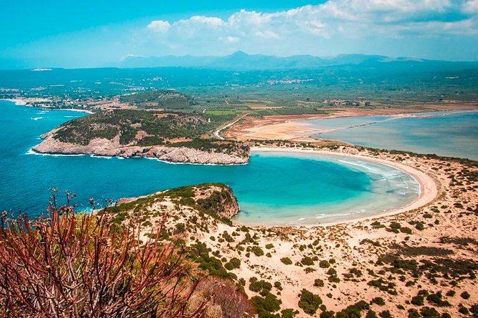
Kalamata hiking at Navarino Bay follows a guided route of 4 hours from Divari beach near Gialova, around the lagoon and over the dunes to the omega-shaped Voidokilia beach, then up past Nestor’s Cave to the Paleokastro fort on the hill above.
Divari, signposted as Golden Beach, is a sand bar 1.5 kilometres long between the bay and the brackish Gialova lagoon, a Natura 2000 site. Herons, flamingos and ospreys live around the water, and the protected area hosts 258 bird species and the only African chameleons in Europe, so this Kalamata hiking route doubles as a birdwatching walk.
At the south-west end of Voidokilia, the Kalamata hiking path climbs to Nestor’s Cave, whose roof reaches 30 metres, and continues to Paleokastro, the 13th-century Frankish castle on the Koryphasion headland. The ruins are signposted as closed, so walkers who enter do so at their own risk. From the top, the view runs from the Ionian Sea to the plain of Pylia.
The narrow island of Sphacteria shields the bay from the open Ionian Sea. On the same south-west peninsula, facing the Messinian Gulf, a guided Kalamata hiking day of 11 kilometres and 7 hours crosses small farms and beaches around Koroni, 56 kilometres by road from Kalamata. Our page on Pylos and Navarino Bay covers the rest of the bay.
Which guided Kalamata hiking tours can you book?
Guided Kalamata hiking tours come as half-day walks of 3.5 to 5 hours and a full-day summit trip of 7 hours, booked through GetYourGuide, through Viator or directly with local operators, and they cover gorges, waterfalls, coastal paths and the Taygetos summit.
On GetYourGuide, the Kalamata hiking tour to the Polylimnio waterfalls lasts 3.5 hours, runs with English and Greek guides and needs booking at least 2 days ahead. The Ridomo gorge hike at Kardamyli runs 5 hours as a small-group guided tour and takes bookings up to 10 hours before the start, and both listings offer free cancellation.
Viator lists seven Kalamata hiking products, including a Polylimnio waterfalls hike, walks around Kardamyli and Navarino Bay, the Exochori hike from the mountain towards the sea, the Ridomo gorge hike to the Mana spring and the Viros gorge hike. Local operators sell 4-hour half-day walks, a cobbled-path hike on the Biliovo trail, a 7-hour Taygetos summit day and private trips on request.
When is the best season for Kalamata hiking?
The best season for Kalamata hiking is spring and autumn: mean highs at Kalamata airport reach 19.9°C in April and 24.3°C in October, against 31.4°C in August, while November and December bring the heaviest rain of the year.
Kalamata has a hot-summer Mediterranean climate, with mild, wet winters and hot, dry summers. July averages 1.5 rain days, 367.6 hours of sunshine and a 31.3°C mean high, so a midsummer Kalamata hiking day meets the strongest heat and the least rain of the year.
The wettest months run from November to February, with 141.7 mm of rain in November and 15.7 rain days in December, and snow, rare in the lowlands, settles on the mountains, above all the Taygetus. Spring and autumn sit between the extremes: April has 10.3 rain days and October 9.9, and one operator runs its Kalamata hiking tour all year round.
How hard is Kalamata hiking?
Guided Kalamata hiking is graded easy to moderate: half-day walks last 3.5 to 5 hours at a relaxed pace, the climb above the city gains height from 400 metres to 1300 metres, and the 7-hour Taygetos summit day is the longest outing.
Grades depend on the operator. One company rates its Kalamata hiking climb from Kato Verga as moderate, calls the uphill gain its main feature and asks for basic fitness and hiking experience; another rates its Ano Verga route to the 1316-metre peak of Mount Kalathi easy, with challenging parts, and needs no previous experience.
Operators state lengths in hours rather than kilometres: the half-day Kalamata hiking trips last 4 hours including breaks, and canyoning and gorge days run 4 to 5 hours. Local terms require an average physical condition, while the Stenosia river walk is listed as suitable for all fitness levels and the Polylimnio canyoning day as suitable for beginners.
What do you need for Kalamata hiking?
For Kalamata hiking you need hiking shoes or trainers, a hat, sunscreen, a backpack, a bottle of water and comfortable trousers; operators rule out open shoes, sandals and flip-flops, and the changeable Greek weather calls for an extra warm or waterproof layer.
Carry a reusable bottle and fill it before the walk: one operator asks Kalamata hiking groups to cut plastic waste and hands out bags for small clean-ups along the trail. A hiking backpack holds the water, hat and sunscreen, and a light layer helps in the cool, fresh air of the mountain villages, even in summer.
Greek weather can bring sunshine, rain, wind and a spread of temperatures in one Kalamata hiking day, so local terms ask for clothing for every season. Each participant also signs a waiver before the tour, online or on paper, and personal travel and health insurance stay the walker’s responsibility, while operators carry liability insurance.
How do you reach the trailheads for Kalamata hiking?
You reach Kalamata hiking trailheads by car, with the EO82 road running from the city into the Taygetus, by KTEL Messinia buses to Kardamyli, Stoupa, Koroni, Pylos and Methoni, or by the pickup that selected guided tours include from hotels in Kalamata.
A car gives Kalamata hiking the widest reach. The EO82 links Kalamata with Sparta across the Taygetus, the range whose slopes also hold the Byzantine town visited on Mystras tours, and the EO7 serves the west. One operator offers free parking near its meeting point, and on the winding Mani roads a short distance on the map takes longer than it looks.
KTEL Messinia runs the regional buses, with timetables and online tickets on its website. Its West Mani line runs every day through Kardamyli, the Kalamata hiking base for the Ridomo gorge, and Stoupa to Oitylo, which tour sellers pair with the Diros Caves in Mani. Airport lines run to Pylos, a base for Pylos tours, and to the castle towns of a Methoni and Koroni tour.
The GetYourGuide Polylimnio hike adds pickup and a short van ride, the Kardamili climbing day includes hotel transfers, and one local operator arranges hotel pickup on request but otherwise leaves the trip to the meeting point to the walker. Arriving Kalamata hiking visitors find a bus stop outside the airport or book Kalamata airport transfers.
Can Kalamata hiking be combined with river trekking and canyoning?
Yes, Kalamata hiking combines with water days: the Stenosia river trek follows an easy gorge trail to the Kalamaris waterfall in 4 to 6 hours, and the 4-hour Polylimnio canyoning trip adds jumps, swims, abseils and a zipline ride over a lake.
The Stenosia gorge in southern Messinia takes its name from the nearby village. The trek starts with a short walk to the first waterfall, follows an easy path through dense vegetation and over makeshift bridges, and ends with a swim in the clear pool below the Kalamaris waterfall. Backpacks, bottled water and walking sticks come with this Kalamata hiking add-on.
The GetYourGuide canyoning trip in the Polylimnio canyon runs 4 hours with Greek and English guides, and a local operator sells a canyoning and zipline version for beginners and families. Canyoning operators supply the equipment, wetsuits and dry bags, so a Kalamata hiking visitor packs swimwear, a quick-dry T-shirt, shorts and trainers rather than sandals, plus a fleece layer in early spring and late autumn.

What safety rules apply to Kalamata hiking?
Kalamata hiking safety rests on the guide’s judgement: operators cancel for strong winds, steady heavy rain or threatening thunderstorms, switch routes to suit the day’s conditions and the group’s experience and needs, and expect every walker to follow instructions on the trail.
Cloudy skies and scattered showers are no reason to cancel a guided Kalamata hiking trip, but strong wind, steady rain and thunderstorm risk are. After a weather cancellation the walker picks a new date or a full refund. Summer heat is the other hazard: the airport station has recorded 45.0°C, so carry water, a hat and sunscreen.
On the trail, the group accepts the guides’ decisions, and a participant whose health or behaviour puts the group at risk can be excluded from the rest of the trip. Walkers without a guide meet limited signage on the old stone paths and coastal walks of Mani, so a guided Kalamata hiking day keeps navigation with local guides.
Frequently Asked Questions
Can you bring a dog on Kalamata hiking trips?
Only with limits. KTEL Messinia buses carry animals only when they accompany disabled passengers or travel as small pets in a suitable carrier, and the Stenosia river trek lists service animals as allowed. Owners of larger dogs need a car for Kalamata hiking and a word with the operator before booking a guided trip.
Can you go Kalamata hiking as a solo traveller?
Yes. Guided Kalamata hiking groups mix couples, families and individuals, with up to 12 people on a standard group trip, and the GetYourGuide Ridomo gorge hike accepts a booking for one adult. Joining a group gives a solo walker company, a local guide who knows the route and a backup plan when the weather turns.
Can children join Kalamata hiking tours?
Yes, within age limits. Local hiking, river trekking and canyoning trips take children from 10 on group or private trips, and the hike above Kalamata requires a parent to accompany minors. On GetYourGuide, the Ridomo gorge hike sells child tickets from age 7 and the Polylimnio canyoning trip from age 8, so Kalamata hiking families can start young.
Is food included on guided Kalamata hiking tours?
On local operators’ half-day hikes, yes: walkers stop for a picnic of local products, and one company serves fresh bread, garden fruit and vegetables, cheese and homemade olive oil. The GetYourGuide Polylimnio canyoning trip includes a meal and ends with a picnic, and the Stenosia river trek hands out snacks during the Kalamata hiking day.