
Psiloritis stands as the tallest summit on Crete, rising to roughly two thousand four hundred metres in the heart of the island between the Rethymno and Heraklion regions. The mountain also carries the older name Mount Ida, and its bare summit crowns a UNESCO Global Geopark. Walkers reach the top from the Nida plateau above Anogeia, following a marked route that rewards the effort with the small chapel of Timios Stavros. This page maps the climb, the terrain and the seasons so you can prepare a safe ascent. Set your ambitions and your dates for this peak with My Greece Tours.
Psiloritis blends serious mountain walking with deep mythology, since the Nida plateau also shelters the Ideon Cave of ancient legend. The sections below cover the standard route, the summit chapel, the geopark setting, the right season and the kit you must carry before you start. Read each answer first, then work through the detail that follows. Pair this page with our wider Crete travel guide to slot the mountain into a fuller island itinerary, from coastal towns to inland villages. Proper planning turns an exposed ridge into a memorable day above the clouds.
Where does the Psiloritis climb on Crete begin?
The standard climb begins on the Nida plateau above the village of Anogeia, in the centre of Crete. Walkers park on the plateau, follow the marked path uphill, and cover the return route in roughly six to eight hours.
The Nida plateau sits high above Anogeia and forms the natural launch pad for the ascent of Crete’s highest mountain, while the village of Zoniana and its Sfendoni cave lie lower on the same road. Drivers climb a long, winding mountain road from the village to reach the open grassland, where stone mitata shepherds’ huts dot the slopes and mark generations of pastoral life on this high ground. The plateau itself repays an early arrival, so aim to leave the car before the sun climbs high and the heat builds on the lower path.
The village of Anogeia serves as the last real supply point, with bakeries and tavernas that let you top up water and food for the day ahead. Fill every bottle here, because the trail carries no reliable spring once you gain real height on the ridge above the plateau floor.
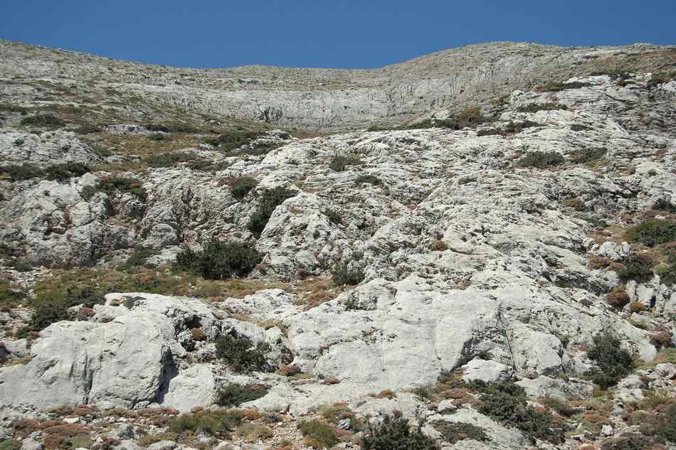
The path leaves the plateau and rises steadily toward the summit ridge, gaining height across rock and low scrub the whole way up. Waymarks guide walkers along the line, yet the ground stays rough underfoot and demands close attention with every single step on the loose, shifting stone. Strong walkers reach the chapel of Timios Stavros in three to four hours, then retrace the same route back down to the parked car on the plateau. Those planning wider hiking in Crete often treat this peak as the headline day of a longer walking trip across the island.
Budget the full six to eight hours for the round trip, add rest stops, and never start so late that darkness catches you high on the exposed upper slopes.
What waits at the summit of Crete’s highest peak?
The summit carries the small chapel of Timios Stavros, the Holy Cross, at roughly two thousand four hundred metres. From this high point walkers gain a sweeping view across the island, taking in both coasts on a clear, settled morning.
The chapel of Timios Stavros crowns the very top of the mountain and gives the whole ascent a clear, human goal to aim at. Pilgrims and shepherds built and rebuilt this simple stone shelter over centuries, and it still draws walkers who pause inside for a quiet moment before turning back. The summit air stays cool even at the height of summer, so pull on a warm layer the moment you stop moving on the exposed top. Views stretch across the ranges of central Crete, and on the clearest mornings you can trace the line of both the north and south coasts at once.
Photographers who reach the top near dawn catch the sharpest light, before heat haze softens the horizon and blurs the distant sea into a pale, flat band. On the eastern slopes, the cherry village of Krousonas opens the climb toward the peak.
The panorama from the top explains why generations have climbed to this cross above the clouds and the working pastures below. Ridges fall away on every side, and the lower peaks of the massif line up in ranks that fade steadily toward the far horizon. Walkers who base themselves near Rethymno or near Heraklion can reach the trailhead within a morning’s drive, which keeps the summit within range of a single long day out. Rest at the chapel, eat, drink, and enjoy the height you have won, yet keep one eye on the sky the whole time you linger.
Weather on the exposed ridge turns fast, so begin the descent well before cloud builds over the peak and cold wind sweeps in across the bare, open rock.
Why does Psiloritis sit inside a UNESCO geopark?
The peak stands inside a UNESCO Global Geopark that protects its limestone landscape, caves and long human story. The Nida plateau holds the Ideon Cave, a mountain cult site of ancient legend, which deepens the geopark’s cultural weight.
The geopark status ties the raw geology of the massif to thousands of years of human use on its high, wind-scoured slopes. Limestone shaped by wind, rain and ice built the plateaus, gorges and caves that define the range and its character today. The Ideon Cave on the Nida plateau ranks among the most storied sites, a mountain sanctuary linked in myth to the childhood of a great god of the ancient world. Visitors who fold the mountain into a run of things to do in Crete gain both a hard walk and a window onto deep island history.
The stone mitata scattered across the pastures show how shepherds have worked this high ground across the centuries, using dry-stone skill handed down through long working generations.
The designation also asks every visitor to tread with care on ground that carries both natural value and rare cultural weight. Walkers keep to the marked paths, carry out each scrap of litter, and leave the mitata and the cave mouths exactly as they first find them. The long history of the massif rewards a slower, curious approach, so read a little before you climb and the whole landscape gains real depth. The European E4 long-distance path crosses the massif, linking the mountain to a walking network that spans the continent from one end to the other.
Serious trekkers can thread Psiloritis into a multi-day route along that trail, turning a single summit day into one high chapter of a far longer journey across the island’s wild spine.
When is the best season to climb Psiloritis?
Late spring through autumn offers the safest window, once the winter snow has cleared from the ridge and the upper slopes. Deep snow lingers into spring on the summit, so most walkers wait for warmer, settled, dry conditions.
Snow lies deep on the high ground through winter and into spring, which closes the standard route to ordinary walkers for months of each year. The season opens as the thaw strips the ridge, usually from late spring, and holds until the first heavy autumn weather returns to the tops. Summer brings the most settled skies of the whole year, yet the exposed upper slopes stay cool and windy even under a strong, high sun. Timing your whole trip well truly matters, so study the wider best time to visit Crete before you fix the climb firmly into your plans.
An early start beats the midday heat on the lower path and gives you a wide margin of daylight for the long, rocky return leg down.
Weather on the summit turns quickly whatever the calendar says, and a bright dawn can give way to cloud and cold wind by noon. Check the mountain forecast the night before, then check it once more at the trailhead before you commit yourself to the full ascent. Clear, stable mornings offer the finest views and the lowest risk, so pick your day with care rather than forcing a fixed date. Storms build fast over the open ridge and can trap unprepared walkers high above the plateau with no shelter at all close to hand.
Turn back without any shame the moment the sky darkens or the wind rises sharply, because the summit will still stand there waiting for a safer, calmer morning to try once again.
What kit do walkers need for this ascent?
Walkers need sturdy boots, warm layers, three or more litres of water, food and an early start. The exposed ridge offers no shelter and no reliable spring, so self-sufficiency and a windproof jacket matter as much as fitness here.
Proper boots top the list, since the trail crosses loose rock and rough scrub that punishes soft trainers within the first hour of walking. Warm layers come next, because the summit stays cold even in high summer and wind chill bites hard on the open, unsheltered ridge. Carry a windproof and waterproof shell, a hat and gloves, and pack far more water than a gentle coastal walk would ever demand of you. Food keeps energy steady across the six-to-eight-hour round trip, so bring bread, cheese, nuts and fruit rather than counting on any hut.
No taverna waits on the mountain itself, and the last shop sits down in the village, so every calorie and every litre must ride up in your own pack from the plateau below.
An early start ranks among the most important choices you make on the day, ahead of almost any single piece of gear in the pack. Leaving the plateau at first light beats the heat, dodges afternoon cloud, and banks the daylight you need for a slow, safe descent. Load a paper map and a fully charged phone, and learn the marked route before you set off across the open, featureless ground. Tell someone your plan and your expected return time, because the ridge carries patchy signal and any real help lies hours away.
A slow, steady pace beats a fast burst that empties your legs before the chapel, so measure the effort and keep enough in reserve for the long walk back down to the waiting car.
Frequently Asked Questions
How high is Psiloritis and where does it stand on Crete?
Psiloritis rises to roughly two thousand four hundred metres, which makes it the highest mountain on Crete. The peak stands in the centre of the island, on the border between the Rethymno and Heraklion regions, so it dominates the skyline from both the north and south coasts. The mountain also carries the older name Mount Ida, a title rooted deep in Greek myth and legend. Its summit holds the small chapel of Timios Stavros, the Holy Cross, which gives climbers a clear goal at the very top of the ridge. The whole massif sits inside a UNESCO Global Geopark that protects its limestone landscape and its long human story.
This central position places the peak within a morning’s drive of the island’s two largest cities, which keeps a summit day realistic even for visitors based on the coast for a wider Crete holiday. The mountain therefore anchors both the map and the imagination of central Crete.
How long does the Psiloritis climb take from the Nida plateau?
The standard climb from the Nida plateau above Anogeia takes most walkers around six to eight hours there and back. Fitter, faster hikers reach the summit chapel in three to four hours, then need a similar span for the descent to the car. Rest stops, photo pauses and lunch at the top all stretch the total, so treat eight hours as a sensible working figure for planning the day. The path gains height steadily across rock and low scrub, and the rough ground slows progress more than the raw distance alone might suggest. An early start matters, because it beats the midday heat on the lower slopes and banks daylight for the long return.
Walkers should reach the plateau soon after dawn, climb through the cooler morning air, and aim to be heading down well before any afternoon cloud builds over the exposed summit ridge above. Plan the timing as carefully as you plan the gear.
Do I need a guide to climb Crete’s highest mountain?
Confident, well-equipped hill walkers can follow the marked route from the Nida plateau without a guide in settled summer weather. The path carries waymarks, and the round trip stays within a single long day for anyone with solid fitness and good, broken-in boots. A guide still adds real value, and less experienced walkers should strongly consider hiring one for the day. Local guides read the fast-changing mountain weather, know the safest line across the loose upper rock, and share the myth and geology that give the massif its depth. The European E4 long-distance path crosses the range, and anyone linking the peak into a multi-day trek gains most from expert support on the ground.
Solo climbers and guided groups alike should tell someone their plan, carry a map and a charged phone, and turn back the moment the sky darkens over the ridge. The summit stays put for a safer, calmer day.