
Sfakia sits on the south-west coast of Crete, a mountainous and thinly populated region within the Chania regional unit. Steep gorges drop from the White Mountains straight to the Libyan Sea, and stone villages cling to a high plateau above the water. The region carries a long reputation for fierce independence and an unbroken tradition of resistance. Its capital is the small port of Chora Sfakion, the gateway to a roadless stretch of coast reached only by boat or on foot. This guide maps the region for travellers who want empty roads, wild scenery and the slower, traditional side of the island you can plan with My Greece Tours.
Travellers reach Sfakia for wild scenery, quiet pebble coves and a slower pace far from the northern resorts. Chora Sfakion anchors the ferry line west along the roadless coast, while gorges, castle ruins and clifftop villages fill the interior. The sections below cover how to reach the region, its beaches and boat trips, the mountain gorges, the Frangokastello coast to the east, and Sfakian food. Read each part alongside our wider Crete travel guide to fit this corner into a longer island route across the south and west.
Where is Sfakia on the map of Crete?
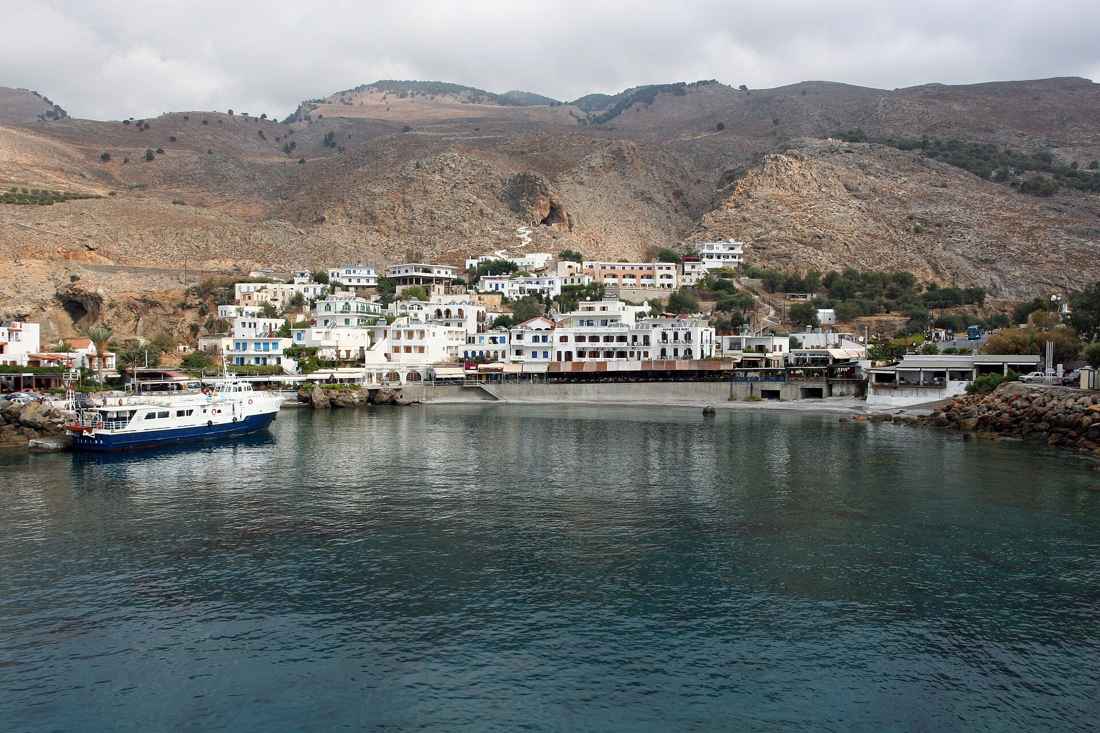
Sfakia occupies the south-west coast of Crete inside the Chania regional unit. The White Mountains rise directly behind the shore, and the small port of Chora Sfakion serves as the region’s capital and main gateway.
Sfakia stretches along the south-west shore of Crete, hemmed between the peaks of the White Mountains and the open Libyan Sea. The region belongs to the Chania regional unit, and the city of Chania on the north coast is the usual arrival point before the drive south. A single mountain road climbs onto a high plateau, then drops through steep switchbacks to Chora Sfakion, the small port that acts as the regional capital. The landscape here reads as vertical rather than flat: gorges cut deep clefts toward the water, and stone villages perch on rocky ledges high above the coast.
Drivers should treat the mountain crossing as the day’s main event, allowing generous time for the gradient, the tight bends and the long views back over the wild interior below.
The road network stops abruptly at the coast, which shapes how the whole region works for a visitor. Chora Sfakion marks the end of the tarmac for the western shore; beyond it the coast turns roadless, and passenger ferries take over the job entirely. Trip planning starts with the wider list of things to do in Crete, then narrows to this southern pocket once travel dates are fixed. A hire car handles the mountain descent and the villages of the high plateau, but the seaside hamlets to the west need a boat. Public buses link the north coast with Chora Sfakion in summer, dropping walkers at the port for onward ferries.
Fuel stops are scarce on the plateau, so drivers fill the tank in Chania before the climb over the range.
How do you get around the Sfakia coast in Crete?
Ferries run west from Chora Sfakion along a roadless shore to Loutro and Agia Roumeli. No coastal road links these settlements, so boats and footpaths carry all traffic between the villages strung along this southern edge of Crete.
Boats do the work that roads cannot along this rugged coast. From Chora Sfakion a passenger ferry line runs west to Loutro, a car-free hamlet built around a sheltered horseshoe bay, then continues to Agia Roumeli at the mouth of the Samaria Gorge. The vessels double as the local bus service, carrying walkers, day trippers and villagers between points the tarmac never reaches. Timetables tighten outside the summer season, so travellers confirm departures the day before rather than assuming a fixed hourly schedule. Loutro rewards an overnight stay: no cars reach it, the waterfront tavernas open straight onto the bay, and footpaths lead out to quiet pebble coves on either side.
The ferry deck also gives the clearest possible view of the sheer cliffs that wall off this remote southern shore.
Walkers link the same settlements on foot along the old coastal path, a stone-and-scree route that traces the shoreline between the bays. The trail runs from Chora Sfakion west toward Loutro in a half-day walk, with shade in short supply and drinking water carried from the very start. Hikers coming off the Samaria Gorge often finish at Agia Roumeli and then take the ferry east to Chora Sfakion, closing a classic south-coast loop. The rocky path demands sturdy footwear and a steady head for the exposed sections perched above the sea.
Boat and trail work together here: most travellers walk one leg for the raw scenery, then ride the ferry back to spare their knees and reach the port well before the last scheduled departure of the day.
What gorges and mountains define Sfakia in Crete?
The White Mountains tower over Sfakia, sending deep gorges down to the sea. The Aradena Gorge and the nearby Samaria Gorge cut the sharpest clefts, giving this part of Crete its vertical, hard-edged mountain character.
The White Mountains give Sfakia its rocky backbone, their bare limestone summits holding snow well into late spring. Gorges slice through the range and empty onto the coast, and the Aradena Gorge ranks among the most dramatic, spanned by a high iron bridge that draws bungee jumpers to its narrow deck. The gorge descends through a tight rock corridor to a pebble beach on the Libyan Sea, a demanding route with iron ladders bolted to the steepest pitches. Walkers reach the trailhead from the plateau village of Aradena, itself half abandoned and ringed by drystone walls.
The sheer scale of the drop startles first-time visitors: high walls close overhead while the path threads the dry streambed below, and the sea appears only near the very end of the long descent.
Sfakia’s most famous gorge lies just to the west, where the Samaria Gorge runs sixteen kilometres from the high mountain plateau down to Agia Roumeli on the coast. Walkers enter from the north side high in the range and finish at the Sfakian shore, then ride the ferry east to Chora Sfakion to complete the crossing on foot and by boat. The gorge stays open right through the warm months and closes when winter rains raise the sharp risk of flash floods. The high plateau villages of Sfakia sit above these clefts, their stone houses turned inward against the wind off the peaks.
Shepherds still graze the upper slopes, and the mountain tradition of self-reliance that shaped the region’s proud history grows directly from this steep, water-scarce terrain.
What can you see along the Frangokastello coast in Crete?
East of Chora Sfakion the shore flattens into a coastal plain crowned by Frangokastello castle, a Venetian fortress by the sea. The stretch pairs shallow sandy shallows with historic ruins, a gentler face of southern Crete.
The coast east of Chora Sfakion softens from cliff into open plain, and the Venetian fort of Frangokastello stands square against the sea. The castle went up under Venetian rule in the fourteenth century to police this restless corner of the island, its four corner towers and blank curtain walls still intact above the shallows. A broad shallow bay spreads below the walls, its warm, waist-deep water making it the calmest swimming on the Sfakian coast. Local legend ties the site to a dawn mirage of marching figures, the Drosoulites, said to appear in early summer.
The fort anchors a small resort strip of tavernas and rooms, a quieter and flatter base than the port for travellers who prefer sand underfoot to pebbles and steep descents.
The Frangokastello plain also carries older and later layers of history beyond the castle itself. Ottoman-era remains and worn Venetian stonework dot the coast, marking the long contest for control of this defiant region. The flat terrain draws a different traveller than the western cliffs: families settle here for the safe shallows, while walkers use it as a low-level base between gorge days. Sunsets over the Libyan Sea colour the castle walls, and the ground stays warm long after dusk. Cyclists find the coastal lanes gentler here than anywhere else in Sfakia, linking beach hamlets across the plain.
The contrast with Chora Sfakion sums up the region’s range, from vertical port and roadless cliffs in the west to open sand and fortress ruins in the east.
What is Sfakian food and tradition?
Sfakian pie leads the local table, a thin cheese pastry pan-fried and served with honey. The dish belongs to a wider mountain culture of shepherding, self-reliance and fierce independence rooted in the region’s rugged terrain and long history.
Sfakian pie is the region’s signature dish, a paper-thin round of dough wrapped around soft white cheese, pan-fried until golden and finished with a generous drizzle of thyme honey. The pie belongs to a shepherd’s kitchen built on what the mountains provide: cheese from hill flocks, foraged wild greens, snails and slow-cooked lamb or goat. Tavernas in Chora Sfakion and the high plateau villages serve it fresh right through the day, often alongside a small carafe of home-distilled raki. The dish travels well onto the ferry routes toward the western hamlets, where waterfront kitchens turn it out to order for tired arriving walkers.
Honey ties the whole plate together, its floral sweetness cutting the salt of the cheese in a careful balance the region has kept for generations of mountain households.
Food here sits inside a broader tradition of independence and resistance that visiting outsiders quickly sense for themselves. The region held out through repeated waves of foreign rule, and its villages guard a fierce memory of self-government that shapes local pride to this day. Hospitality follows a strict unwritten code: a stranger is fed and sheltered without question, and a shared meal seals lasting trust. Travellers arriving from cosmopolitan northern towns notice the shift at once, the pace slower and the welcome far more direct. Feast days fill the village squares with lyra music, dancing and long communal tables, and the same dishes appear that a shepherd’s family would have set out a century ago.
Eating in Sfakia is less a simple meal than a full introduction to how the proud region sees itself.
Frequently Asked Questions
How many days do you need in Sfakia?
Two to three days let you take in the region without rushing the demanding mountain roads. Day one covers the long drive south from the north coast, the switchback descent to Chora Sfakion and a relaxed afternoon on the quiet port beaches. Day two suits a morning ferry west to Loutro for a car-free overnight, with a coastal walk out to the nearby coves. Day three works well for the Frangokastello plain to the east, its Venetian castle and warm shallow bay, or for a gorge walk finished by ferry back to the port.
Walkers building the region around the Samaria crossing should add a further day, entering the gorge from the high plateau and closing the loop by boat. A single overnight only skims the surface here, since the roadless western coast and the open eastern plain pull in opposite directions from the small central port. Pace the visit slowly and let the mountain scenery set the rhythm rather than a tight timetable.
Is Sfakia suitable for families with children?
Sfakia suits active families who enjoy beaches and boats far more than nightlife or big crowds. The Frangokastello plain to the east is the easiest base for young children, with a broad, shallow bay of warm waist-deep water and flat open ground around the castle for exploring. Ferry rides west to Loutro turn plain transport into a real outing, and the hamlet has no cars, so children roam the waterfront freely and safely. Parents with older, sure-footed children can tackle a gorge together, carrying ample water and starting early to beat the fierce midday heat. The mountain roads demand real care with car-sick passengers, so slow driving and regular stops help greatly on the winding descent.
The region lacks the resort facilities of the busy north coast, which is exactly the point: it trades water parks and loud clubs for pebble coves, ancient castle walls and calm swimming under wide open skies.
When is the best time to visit Sfakia?
Late spring and early autumn give the best overall balance of warm sea, open ferries and comfortable walking weather. May and June bring wildflowers to the high plateau, snow still capping the White Mountains and the gorges freshly open after the winter. September and October hold warm water for swimming while the fierce midsummer heat eases on the exposed coastal paths. High summer works well for beach days and reliable boat timetables, though the gorges grow punishing under the sun and shade runs desperately short. Winter closes the Samaria Gorge and thins the ferry schedule right down, leaving the plateau villages quiet and most tavernas firmly shut.
Walkers should time the gorges for spring or autumn, when the streambeds carry a gentle trickle rather than a dangerous flood and the temperature on the long descent stays kind. Confirm your ferry departures the day before, whatever month you finally choose to travel.