
The Santorini caldera is a vast, flooded volcanic crater, around 4 kilometres wide, formed when a colossal eruption 3,600 years ago collapsed the centre of the island into the sea. Its sheer cliffs, crescent shape and clifftop villages define Santorini. This guide covers the formation, the size, the best viewpoints and how to see the caldera.
The caldera is the heart of the wider Santorini travel guide. It gives the island its drama. The sections below cover the caldera.
What is the Santorini caldera?
The caldera is a huge, sea-filled volcanic crater enclosed by towering cliffs, formed when the heart of the island collapsed after a massive eruption. Roughly 4 kilometres across, it gives Santorini its famous crescent shape, with villages perched on the rim 300 metres above the water.
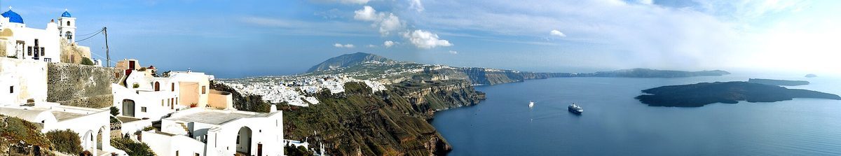
The caldera is what makes Santorini unmistakable. A caldera is the great basin left when a volcano empties its magma chamber and the ground above caves in, and here the sea has flooded the resulting hollow to form a deep, almost circular bay ringed by dark, banded cliffs. The whitewashed villages of Oia, Fira and Imerovigli cling to the very edge of these cliffs, 300 metres above the water, looking down on the caldera and the small volcanic islands at its centre. This sunken crater, not a beach or a single sight, is the island’s defining feature, set within the wider Santorini villages. Its origin is dramatic.
How was the caldera formed?
The crater was created by the Minoan eruption around 1600 BC, one of the largest in human history, which blasted out the volcano’s core so the centre of the island collapsed into the sea. The eruption buried the Bronze Age town of Akrotiri and may have helped end Minoan Crete.
The caldera is the scar of a cataclysm. About 3,600 years ago, in the so-called Minoan eruption, the volcano ejected an enormous volume of ash and pumice over roughly two weeks, emptying its magma chamber so violently that the central part of the then-circular island collapsed inward and the sea rushed in. The blast buried the prosperous Bronze Age settlement of Akrotiri under metres of ash, preserving it like a Greek Pompeii, and the resulting tsunamis and ashfall are believed to have hastened the fall of Minoan civilisation on nearby Crete. The volcano remains active, building the islets at the caldera’s heart, set out alongside the guides to Akrotiri and the Santorini volcano. Its scale is remarkable.
How big is the caldera?
The caldera measures about 12 by 7 kilometres, with the bay roughly 4 kilometres wide, and its waters reach around 380 to 400 metres deep, among the deepest in the Aegean. The cliffs rise up to 300 metres above the sea, making it one of the largest sea-filled calderas in the world.
The caldera’s dimensions are genuinely vast. The flooded basin stretches roughly 12 kilometres by 7, with the open expanse of water about 4 kilometres across, while the sea within it plunges to around 380 to 400 metres, far deeper than most of the surrounding Aegean and too deep for cruise ships to drop anchor, so they moor on buoys instead. The encircling cliffs soar as much as 300 metres straight up from the water, banded in the reds, blacks and greys of successive lava and ash layers, with Oia, Fira and Imerovigli strung along their top. It is reckoned among the largest and most spectacular marine calderas anywhere, set out alongside the guide to the Santorini cruise port. The views are world famous.
Where are the best caldera views?
The best caldera views are from the rim villages of Oia, Imerovigli and Fira, which look straight down on the bay and the volcano. Imerovigli, the highest, is nicknamed the Balcony to the Aegean, while Oia is most famous for the sunset and Fira for its lively clifftop walk.
The whole western rim is a balcony over the caldera. Oia, at the northern tip, offers the most celebrated panorama, its blue domes and windmills framed against the bay, and is the classic sunset spot. Imerovigli, the loftiest of the villages, earns its title as the Balcony to the Aegean, with Skaros Rock jutting out below into the crater, while the capital Fira gives a long, animated clifftop promenade looking down on the Old Port and the volcanic islets. Firostefani, between them, is quieter but just as beautiful. For a different angle, the Fira-to-Oia path traces the rim the whole way, set out alongside the guides to Oia, Imerovigli and the Fira to Oia hike. Seeing it from the water is best of all.
How do you explore the caldera?
You explore the caldera by boat cruise across the bay to the volcanic islets of Nea Kameni and Palea Kameni, by walking the clifftop rim from Fira to Oia, or simply by gazing from the villages. A caldera sailing or catamaran cruise, often at sunset, gets you onto the water at its heart.
The caldera rewards seeing from several angles. The finest is from the water: a caldera boat cruise or catamaran trip sails across the bay to the black volcanic islet of Nea Kameni, where you can hike to the steaming craters, and on to swim at the warm hot springs of Palea Kameni, frequently ending with the sunset viewed from the sea off Oia. On land, the spectacular 10-kilometre Fira-to-Oia walk follows the cliff edge for the whole length of the rim, and the rim villages themselves are perfect for simply soaking up the view over a meal. Boat tours leave from the Old Port below Fira and from Ammoudi Bay, set out alongside the guides to Santorini boat tours and Santorini sailing tours. The questions below cover the points travellers ask most.
Frequently Asked Questions
What is the caldera in Santorini?
The Santorini caldera is a large, sea-filled volcanic crater enclosed by cliffs up to 300 metres high, formed when the centre of the island collapsed after a massive eruption 3,600 years ago. About 4 kilometres wide, it gives Santorini its crescent shape and famous clifftop views.
How was the Santorini caldera formed?
It was formed by the Minoan eruption around 1600 BC, one of the largest in human history, which emptied the volcano’s magma chamber so the island’s centre collapsed and the sea flooded in. The eruption buried the Bronze Age town of Akrotiri under ash.
Where are the best views of the Santorini caldera?
The best caldera views are from the rim villages of Oia, Imerovigli and Fira, perched 300 metres above the bay. Imerovigli is the highest, Oia is famous for the sunset, and the Fira-to-Oia path traces the whole rim. A boat cruise shows the caldera from the water.