
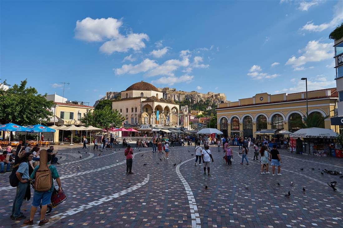
Five kinds of outdoor stop make up the free open-air sites Athens keeps open: pedestrian promenades, ancient remains seen from the pavement, squares, building exteriors and whole quarters. The walk from Acropolis station along Dionysiou Areopagitou Street meets none of the gates that close beside it.
Eight central metro stations start short walks to these stops, and the gated archaeological areas beside them keep their own hours. Travellers who are still choosing their next region can read the Greece Tours homepage, which lists every area the site covers.
What counts as free open-air sites Athens offers, and what keeps them free all week?
Free open-air sites Athens offers fall into five groups: pedestrian streets, visible ancient remains, squares, building exteriors, and whole quarters. They stay free when people reach them from public streets or open ground without passing a ticket gate or controlled entrance.
Free open-air sites Athens presents on public streets remain walkable at any hour. A pavement, square, or open lane belongs to the city’s public space. You can pause there without buying entry.
Pedestrian promenades and lanes form the first group. Dionysiou Areopagitou Street begins beside Amalias Avenue, opposite Hadrian’s Arch and the Temple of Olympian Zeus. It continues along Apostolou Pavlou Street towards Thission.
The promenade gives free open-air sites Athens a clear walking setting beside the Acropolis. From the pavement, you see the outer slopes and nearby monuments. The street itself has no ticket gate.
Ancient remains visible from public pavement form the second group. At Monastiraki Square, part of the Eridanos riverbed remains open beneath a metal railing. Passers-by look down from the square.
This example belongs among free open-air sites Athens keeps accessible from a public square. The visible riverbed is not the same as entering a fenced archaeological site. The railing marks the viewing edge.
Squares and civic monuments form the third group. Syntagma Square sits above the metro station and serves as a central public meeting place. The nearby Parliament exterior and Monument of the Unknown Soldier face public approaches.
Free open-air sites Athens includes civic spaces because the pavement gives visitors direct access. You can view the outside of public buildings without entering an interior room. The square remains a public route.
Stadium and building exteriors form the fourth group. The Panathenaic Stadium stands on Vasileos Konstantinou Avenue in Pangrati. Its outside marble seating and curved façade can be viewed from the surrounding public road.
The stadium itself is a historic archaeological site with controlled entry. Its exterior belongs to free open-air sites Athens visitors can see from outside. Entering the stadium is a separate activity.
Streets across whole quarters form the fifth group. Monastiraki has narrow, irregular streets around Adrianou, Pandrosou, Ifaistou, Thiseiou, Agiou Filippou, Astigos, and Ermou Streets.
These free open-air sites Athens walkers use are not one monument. They are public streets within a district. The quarter stays open as a normal part of the city, although individual businesses have their own rules.
The rule is about access, not age or appearance. A place counts here when a visitor reaches it from public pavement or open ground. No ticket desk, turnstile, or controlled entrance blocks the view.
Free open-air sites Athens lists can sit beside a paid attraction. That location does not make the public pavement paid. Walkers need to separate the outside view from entry into the managed site.
The Ministry of Culture lists free admission for state archaeological sites, monuments, and museums on set dates and for stated visitor groups. That policy does not make every outdoor state site free every day.
For free open-air sites Athens visitors need a simple test. If a fence surrounds a state archaeological area and a booth controls entry, treat it as a different place. The surrounding public pavement remains the free viewing point.
A gate changes the category, even when the site sits outdoors. The Acropolis, the Panathenaic Stadium interior, and other controlled areas require visitors to follow their own entry arrangements.
Free open-air sites Athens therefore means outdoor city space, not every open-sky attraction. Streets, squares, visible edges, and building exteriors fit. Gated archaeological grounds do not fit simply because the sky is above them.
Which metro stations open the shortest walks to free open-air sites Athens groups together?
Eight central stations connect short walks to free open-air sites Athens groups around streets, squares, and exteriors. Acropolis and Thissio form the strongest one-way pair because both ends meet the long pedestrian route beside the Acropolis.
Free open-air sites Athens visitors can reach from the metro begin with Acropolis station. It is on Line 2, the red line. Exits stand on Makrygianni Street and Athanasiou Diakou Street, beside Dionysiou Areopagitou Street.
The shortest stated outdoor connection from Acropolis station is the Panathenaic Stadium at 1,000 metres. The stadium’s official visitor page gives the same distance from Acropolis, Syntagma, and Evangelismos stations.
Syntagma station is the junction of the red Line 2 and the blue Line 3. It lies beneath Syntagma Square, so the nearest public square begins at the station exits. The distance is 0 metres.
Free open-air sites Athens walkers reach from Syntagma include the square, Parliament’s exterior, and the Monument of the Unknown Soldier. The station also opens towards Panepistimiou Avenue and Ermou Street.
Monastiraki serves Lines 1 and 3, the green and blue lines. One station exit opens at Monastiraki Square. The nearest outdoor stop is therefore 0 metres from that square entrance.
The station page places Monastiraki beside narrow streets and names Adrianou, Pandrosou, Ifaistou, Thiseiou, Agiou Filippou, Astigos, and Ermou Streets. Free open-air sites Athens groups in this area begin as soon as you reach the square.
Thissio serves Line 1, the green line. It stands at the northern end of the Dionysiou Areopagitou and Apostolou Pavlou pedestrian route. The nearest outdoor stop is 0 metres from the station area.
Free open-air sites Athens links between Acropolis and Thissio create the strongest one-way walk. Start at Acropolis station, follow the pedestrian route, and finish at Thissio station. This choice avoids returning along the same path.
Kerameikos serves Line 3, the blue line. The station is underground in central Athens and has exits at street level. Its nearest outdoor stop begins at the public pavement outside the station, 0 metres away.
Free open-air sites Athens includes around Kerameikos only when viewed from public streets. The station’s Wikipedia entry identifies Line 3 and places the station in Athens. Keep any fenced archaeological grounds separate from the pavement.
Evangelismos serves Line 3, the blue line. It is on Vasilissis Sofias Avenue, near Marasli Street. The Panathenaic Stadium’s official page places the stadium 1,000 metres from Evangelismos station.
Free open-air sites Athens walkers can use Evangelismos for the stadium exterior and the surrounding civic avenues. The station also has an entrance near Rizari Park, which is outside this part’s scope.
Panepistimio serves Line 2, the red line. Its exits reach Korai, Panepistimiou near the Academy, and Panepistimiou opposite the National Library. Panepistimiou Avenue begins at the station exits, at 0 metres.
The station page describes Panepistimiou Avenue as a route connecting Syntagma Square and Omonia Square. Free open-air sites Athens visitors can walk along its public pavement and view the façades from outside.
Omonia serves Lines 1 and 2, the green and red lines. The station lies below Omonia Square, with entrances around the square. The nearest outdoor stop is 0 metres from the station.
Free open-air sites Athens includes Omonia Square because the station opens directly into public civic space. The Region of Attica states that the station has eight entrances and exits around the square.
Train times come from the metro operator rather than from a walking map. STASY states that Line 1 begins at 05:00 from its terminal stations. Its last terminal service begins at 00:15.
For Lines 2 and 3, STASY states that the first terminal service begins at 05:30. The last service from Syntagma towards the terminal stations begins at 00:23. On Friday and Saturday nights, it begins at 01:30.
Free open-air sites Athens routes need a time check before an early or late walk. STASY posts arrival times, first services, and last services on station notice boards. Airport trains follow a separate Line 3 schedule.
The airport connection uses Line 3, the blue line. OASA directs airport travellers to use Metro Line 3 between Athens International Airport and downtown Athens.
Free open-air sites Athens visitors can therefore enter the centre from the airport without changing for Syntagma, Monastiraki, or Evangelismos. Check the destination display because airport trains run as a distinct service.
Use Athens metro guide for station planning beyond these eight starting points. Match the line colour with the station name before leaving the platform.
How do the pedestrian promenades link free open-air sites Athens built for walkers?
The city’s unification programme connects separated archaeological areas through public pedestrian space. Dionysiou Areopagitou and Apostolou Pavlou form its paired main streets. These free open-air sites Athens joins make the spaces between monuments part of a visit, rather than gaps to cross.
Dionysiou Areopagitou Street runs east to west beside the southern archaeological areas. Its name recalls Dionysius the Areopagite, Athens’ patron saint. Its eastern end serves the area beside the Acropolis Museum. On a map of free open-air sites Athens, mark the promenade itself, not an entrance into the neighbouring sites.
The street became pedestrianised in the early twenty-first century. Its shape came from an earlier redesign by Dimitris Pikionis in the mid-twentieth century. When first mapped in the nineteenth century, it lay farther north. Those separate changes explain why the modern walking surface is not simply an untouched ancient road.
Apostolou Pavlou Street continues towards Thissio, with early-twentieth-century buildings beside the pavement. The assessed stretch measures 800 metres and descends 31 metres in total. Among free open-air sites Athens offers pedestrians, this is a sloping street rather than a level square. Choose your direction according to how comfortably you manage slopes.
Before the transformation, parked cars occupied Dionysiou Areopagitou. Tourist coaches contributed to congestion on Apostolou Pavlou. The latter’s pedestrianisation work also belongs to the early twenty-first century. The change reclaimed street space for people walking between the buildings and archaeological areas. Look at the full pavement, not just the individual landmarks beside it.
The Ministry of Culture commissioned the wider master plan in the late twentieth century. Its initial joint programme covered six areas. The planning behind free open-air sites Athens has joined addressed traffic overload as well as cultural heritage. Consider the former road space alongside the monuments when deciding what to examine during your walk.
The ministry’s principles protect monuments from every historical period. They also describe archaeological work as limited and reversible. That means changes are designed to be undone. Its programme includes work on traditional and contemporary building facades. Looking towards the street-facing buildings is therefore part of understanding the project, not a distraction from it.
The city’s mobility guide records no steps along its assessed pedestrian connection. For free open-air sites Athens travellers compare by access, that qualification matters. It does not cover every nearby doorway or separate monument approach. Choose the assessed pavement when stairs are a barrier. Do not extend that assessment to adjoining places.
- The official visitor guide describes Dionysiou Areopagitou as tree-lined. Trees belong to the street’s design. Choose a stopping place beside the passage, keeping room for people who are continuing along the boulevard.
- Stone paving gives these free open-air sites Athens pedestrians share a surface with joints. Wheelchair users judged the assessed paving accessible. Check the texture underfoot; step-free does not mean completely smooth.
- Beside the museum, the city’s visual-access guide records a change from stone paving to smooth marble. Look down at this boundary instead of assuming one material continues throughout the promenade.
- Tactile paving assists orientation across free open-air sites Athens has linked here. The city guide warns that vendors and low obstacles can interrupt it. Assess the space beside an obstruction before passing.
- The tactile paving lacks colour contrast, according to the same guide. Its texture identifies the strip. For visitors with reduced vision, a strongly different colour is not available as an orientation aid.
- One mansion carries Art Nouveau and eclectic details from the early twentieth century. The free open-air sites Athens presents along Dionysiou Areopagitou include these later architectural styles. Study its exterior from the pavement.
- Number 17 on Dionysiou Areopagitou has an Art Deco facade designed by Vassilis Kouremenos. It was later protected as a work of art. This address supplies a specific exterior to identify.
- The ministry links its pedestrian network with everyday movement towards the commercial centre. For free open-air sites Athens residents pass during ordinary journeys, public circulation matters alongside cultural visits. Leave passage space when stopping.
Which lanes and steps of the old town count as free open-air sites Athens travellers use?
Anafiotika is free to visit and open twenty-four hours a day, according to a travel guide. Among free open-air sites Athens travellers explore, its residential alleys add stairs and winding passages. Plaka’s named streets provide different settings for examining old-town exteriors.
Adrianou Street lies within protected Plaka and meets pedestrian Kydathineon in the district’s centre. Its name honours the Roman emperor Hadrian. It became a paved street in the early nineteenth century. Include this lane among free open-air sites Athens displays through street history, while treating its building entrances as separate destinations.
Kydathineon Street extends from Filellinon to Adrianou, with stone slabs underfoot and souvenir shops alongside. Its name comes from an ancient Attic district, called a deme. That ancient district corresponded broadly to Plaka. The name is therefore a clue to local history, rather than just a label for the shopping street.
Tripodon Street runs between Thespidos and Lysiou in the old town, beside two-storey houses. Its name recalls bronze tripod trophies once displayed on both sides. Sponsors received them for theatrical performances at Athenian festivals. The free open-air sites Athens preserves in its lanes include this surviving street name, reported as unchanged for 2,500 years.
Mnisikleous Street has its stepped scene between the Lysiou and Prytaniou area. Cafe and taverna tables stand beside the stairs. The name recalls Mnesicles, an ancient architect from the time of Pericles. Treat it as a staircase visit, not a level pavement. Choose another street if climbing steps does not suit you.
Workmen from the island of Anafi founded Anafiotika, within Plaka. They built whitewashed dwellings at night for their families. Craftsmen from other Cycladic islands later joined them, working with wood, stone and marble. Within free open-air sites Athens travellers approach on foot, this quarter records the homes of builders. The quarter grew around a change of monarchy.
The alleys have no names and wind between the houses. Narrow sections require walking in single file. Cats perch around the quarter, while clay and tin planters hold flowers and herbs. Look at these details from the passage without entering a household’s yard. Leave doorways available to the people living behind them.
Residents still use these lanes as their home surroundings. Keep your voice low, especially early in the morning. Do not photograph through windows or enter private courtyards uninvited. At free open-air sites Athens shares with households, access to the lane is not access to a home. Save conversations for somewhere that does not disturb residents.
- On Adrianou, the Municipal School has a Doric entrance with two columns and a pediment. Panagiotis Kalkos designed it in the nineteenth century. It continues to house a primary school; examine the exterior.
- At 96 Adrianou, the stone ground-floor facade has small paired windows. These free open-air sites Athens reveals through building fronts reward looking at materials as well as decoration. Notice the plain stone from outside.
- Number 27 on Kydathineon is an austere stone-built mansion with French-style window joinery. Its balcony rests on three decorated marble supports, called corbels. Look upwards from the pavement to identify them.
- Tripodon 32 is a listed blue two-storey house from the early nineteenth century. A Greek film used it in the mid-twentieth century. The free open-air sites Athens shows here carry screen history too.
- Tripodon 28 is another nineteenth-century house. Its late-twentieth-century restoration received a heritage award. The restoration date is separate from the building date; do not assume every visible element is original.
- Mnisikleous hosted music venues in the second half of the twentieth century. Its stairs also appeared in Greek and international films. These free open-air sites Athens travellers examine outside carry performing-arts history.
- Greek refugees from Asia Minor settled in Anafiotika in the early twentieth century. Part of the quarter was later demolished for archaeological research. The state began buying houses in the late twentieth century.
- The first recorded residents were a carpenter and a construction worker. The free open-air sites Athens includes within this residential fabric carry working history at house scale. Look beyond grand public buildings.
Which fences of the Ancient Agora and Roman Agora give free open-air sites Athens pedestrians a view in?
Adrianou Street gives a street-level look at the Stoa of Attalos, while Apostolou Pavlou opens views toward the Temple of Hephaestus. Around the Roman Agora, public streets reveal parts of its monuments. The gates and ticket offices mark the limit of the archaeological sites.
These free open-air sites Athens pedestrians see from public streets are not the same as entry to the archaeological areas. The Ministry of Culture directs Ancient Agora visitors to its gate at Thiseio Square. Its information page also confirms that admission covers the archaeological site and its museum.
The Stoa of Attalos, one of the free open-air sites Athens pedestrians meet beside the agora, stands along the Ancient Agora’s eastern side. Its exterior faces Adrianou Street, where passers-by can look at the long building from outside. The Ministry describes it as restored to serve as the site museum, but the street view does not include the site behind it.
For a pavement visit to these free open-air sites Athens offers, keep to Adrianou Street and look toward the Stoa’s outer frontage. The Ancient Agora’s visitor entrance is a separate point at Thiseio Square. The ministry’s notice directs visitors there while work affects the Adrianou entrance.
- At Adrianou Street, the Stoa of Attalos is the clear street-side feature of these free open-air sites Athens pedestrians pass. Look toward its eastern frontage. The building also serves as the Ancient Agora’s site museum, according to the Ministry of Culture.
- On Apostolou Pavlou, the public pedestrian way reaches the Thissio area. The City of Athens guide says nearby cafes have views of the Temple of Hephaestus. Walk this stretch by daylight to see the temple above the site boundary.
- From Thissio, stay on the public route along Apostolou Pavlou and look toward the Ancient Agora. The City of Athens guide places this pedestrian precinct near historic Thissio and confirms the temple view from the street’s cafes.
- Beside the Ancient Agora, the Athens–Piraeus electric railway marks the excavations’ northern edge. The American School of Classical Studies identifies the railway as the northern boundary. The view is of the line beside the site, not access to its enclosed ground.
- The Ancient Agora’s Thiseio Square gate is where the ministry directs visitors entering and leaving the archaeological site. The Ministry confirms that admission is ticketed. The public streets remain separate from the site, giving free open-air sites Athens pedestrians a clear boundary to follow.
- At the Roman Agora, the fence separates the archaeological area from the surrounding streets. A ticket booth sits across the northern street, according to a visitor account. From outside, the northeast corner of the porticoes and the Gate of Athena Archegetis are visible.
- On the Roman Agora’s west side, the Gate of Athena Archegetis has four Doric columns and a Pentelic-marble base. The Ministry says the Athenian People dedicated it to Athena. A travel guide points to Adrianou Street for an exterior look, with early morning as its suggested time.
- From the street near the Roman Agora, the Fethiye Mosque’s exterior is another visible feature. The Region of Attica places it within the archaeological site at Panos Street. Its front has five arches and five small domes, details visible without entering.
The Roman Agora’s fence and ticket booth help visitors separate the outside view of free open-air sites Athens shows from the archaeological precinct. The Ministry lists the Gate of Athena Archegetis, the Fethiye Mosque and other remains within the site. The exterior look stops at the boundary, even where a monument is visible from the street.
For broader context, the Ancient Agora and Roman Agora have their own site descriptions. Here, the focus stays on public streets and what walkers can see without crossing a controlled entrance.
Walk these free open-air sites Athens streets in daylight for a straightforward look at the stone façades and boundaries. Apostolou Pavlou is a public pedestrian way, while Adrianou gives a direct view of the Stoa.
Which Roman remains and squares around Monastiraki are free open-air sites Athens streets pass?
Areos Street gives a public view of Hadrian’s Library’s western façade, while Monastiraki Square holds the exterior of Tzistarakis Mosque and the Pantanassa basilica. Nearby, Avissynias Square hosts an open-air bazaar on Sundays. These street views stay outside the archaeological sites and their controlled entrances.
These free open-air sites Athens pedestrians see around Monastiraki fit into ordinary streets and squares. The City of Athens guide traces a pedestrian approach from Monastiraki along Areos Street toward Hadrian’s Library. It describes the short street as slightly uphill, so the façade appears along a public walking route.
Hadrian’s Library’s western wall and columns face Areos Street, a stop among the free open-air sites Athens streets pass. A visitor guide says much of the marble structure is visible from the street. The Ministry describes a Corinthian entrance on the building’s west side. Choose daylight to make the exterior details easier to see from the pavement.
The library’s street frontage is a separate stop among the free open-air sites Athens offers, distinct from the archaeological area beyond it. Walk along Areos Street and look toward the west-facing wall and columns. The route joins the square to the site boundary, so a passer-by can view the exterior without entering.
- Areos Street is the public approach to Hadrian’s Library from Monastiraki. The visible west side has a Corinthian propylon, or entrance structure, and a marble wall. The Hadrian’s Library guide covers the monument; this stop concerns its street-facing exterior.
- Monastiraki Square meets Pandrosou and Areos Streets at the Tzistarakis Mosque. Archnet describes the exterior as a square-plan, two-storey building, with an upper tiled dome and an open portico on its west side. Sunday afternoon is a suggested time to experience the square’s market atmosphere.
- At Avissynias Square, Ifestou Street ends by an antique market. The City of Athens guide says an open-air bazaar spreads south of the square toward Thissio on Sundays. Sunday is also the city guide’s recommended day for browsing the flea market.
- On Monastiraki Square, the small Pantanassa basilica remains from an earlier monastic compound. Its bell tower is a later addition, according to a Byzantine heritage guide. A Sunday-afternoon walk suits the surrounding market scene, though that recommendation is for the square, not church visiting.
- Walk from the square toward Avissynias to see stalls and open-air browsing on market day. The city guide identifies collectors’ goods and street bands at the Sunday bazaar. This is a public street scene; purchases are separate from walking through the area.
Monastiraki Square works as a useful point to orient yourself among these free open-air sites Athens streets pass. The official Athens guide describes the area as suitable for browsing by day. It also notes that Adrianou Street serves as a main flea-market artery.
At Avissynias, the bazaar’s Sunday setting gives the square a clear day for a visit. The city guide says the open-air market reaches toward Thissio. Walk the public streets around the stalls, then continue toward Monastiraki Square for the mosque and Pantanassa exterior.
For a quieter look at stonework among free open-air sites Athens keeps, follow Areos Street during daylight and pause outside Hadrian’s Library. For the market atmosphere, choose Sunday afternoon around Monastiraki Square. These are separate choices: one focuses on the Roman façade, the other on outdoor trading and street life.
The public approach does not open the library or the Roman Agora. Their archaeological areas have controlled entrances, while the squares and surrounding streets remain places to walk past. Keep to the public pavement for free open-air sites Athens pedestrians can view without entering.
Across this compact area of free open-air sites Athens pedestrians cross, each stop has its own street-side detail. Areos has a marble wall, the square has a domed mosque, and Avissynias has market stalls. The Pantanassa basilica adds a church exterior beside the same square. A daytime walk links these places without relying on an indoor visit.
What do free open-air sites Athens shows around the Panathenaic Stadium and the Zappeion look like from outside?
The stadium’s marble outer curve and the Zappeion’s columned face create two distinct street views on adjoining central avenues. These free open-air sites Athens passers-by can inspect without entering either building. Access beyond the stadium gate belongs to a separate visitor arrangement.
The Panathenaic Stadium sits on Vasileos Konstantinou Avenue in Pangrati. From the pavement, its pale seating tiers bend around the arena in a horseshoe shape. The rebuilt exterior is white marble. The official visitor page lists Syntagma, Akropoli, and Evangelismos, each about one kilometre away. Among free open-air sites Athens offers, the stadium’s form defines its street view.
On this avenue, free open-air sites Athens passers-by see begin with the stadium’s outer sweep, not its track. The gate area gives a closer look at the entrance architecture. The stadium authority describes porticoes at the main entrance and statues decorating that zone. These details can be studied from the avenue approach without passing through the entrance.
A named sculpture stands opposite the stadium address: the visitor page places the entrance across from the Discobolus statue. This gives the gate a street reference. The marble facade recalls the first modern Olympics held at the stadium, according to its history record. Free open-air sites Athens shows here keep that Olympic setting in public view.
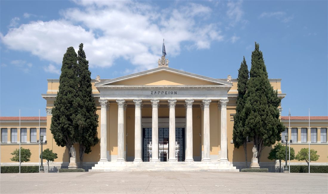
The Zappeion faces Vasilissis Olgas Avenue, rather than the stadium’s avenue. In this part of central Athens, free open-air sites Athens passers-by compare include its neoclassical front and columned portico. The city guide identifies Corinthian capitals there. The official building site describes an inner circular atrium, a feature behind the outside wall.
The front approach lets walkers read the Zappeion as a broad public building with a central columned entrance. Its circular atrium explains the interior plan, though a street visitor sees the outer face. The official site calls the inner court a peristyle. This distinction separates street views from the indoor layout.
Olympic history gives the Zappeion another point of interest. Its official history says fencing at the first modern Olympics took place in its circular atrium. The page also says it later served as an Olympic Village. Its exterior links those events to a landmark. Free open-air sites Athens passers-by see here include a building designed for Olympic use.
Google Maps shows a five-hundred-fifty-metre walk from Zappeion to the Panathenaic Stadium. It gives the trip as eight minutes via Leoforos Vasilissis Olgas. This connection joins two separate public-facing exteriors, not a path through either building. Thus free open-air sites Athens passers-by can see occupy a short urban link between two Olympic places.
Look at the outside details instead of expecting access to indoor spaces. At the stadium, follow the marble curve toward the entrance. At the Zappeion, notice the Corinthian capitals above the portico. Both facades stand beyond their controlled interiors, so the street-side visit remains separate from entry. This is a clear way to compare the two designs.
- Stadium curve: its white marble horseshoe form is clearest from Vasileos Konstantinou Avenue. There, the seating arc rises above the pavement. The official history traces this shape to Roman rebuilding.
- Gate area: the authority notes porticoes and statues at the main entrance. The Discobolus statue stands across from the address. The exterior gives a street-level view of the entrance.
- Zappeion facade: Vasilissis Olgas Avenue gives a direct pavement view of the Corinthian portico and the building’s neoclassical exterior. The city guide confirms the column order. The official site credits Theophil Hansen as its designer. Syntagma is the nearest listed metro station, seven hundred metres away.
- Olympic context: free open-air sites Athens displays here include the stadium that hosted the first modern Olympics. The Zappeion atrium hosted fencing. Each exterior points to a different part of that history.
Which fence line, arch and river bank near the Olympieion are free open-air sites Athens passers-by walk?
Vasilissis Olgas Avenue and Leoforos Amalias give street-side views of the Olympieion fence, Hadrian’s Arch, and the buried Ilissos course. These free open-air sites Athens passers-by can see without crossing the archaeological enclosure. Acropoli station serves the nearby temple area.
The Temple of Olympian Zeus, also called the Olympieion, lies in central Athens between Vasilissis Olgas Avenue and Leoforos Amalias. From the public pavement, its fence marks the edge of the archaeological site, while the columns rise above it. Hellenic Heritage gives the site’s address on Vasilissis Olgas Avenue. The same authority lists Acropoli station for access.
At this boundary, free open-air sites Athens passers-by see include the temple’s outer columns, not its inner precinct. Hellenic Heritage counts fifteen standing columns, with one more fallen nearby. It says the temple once had one hundred four columns. Each shaft measured sixteen point eight nine metres in height, according to that source.
The view shifts with the street edge. Along Vasilissis Olgas Avenue, the column line appears behind the fence. From Leoforos Amalias, the temple enclosure and arch sit in closer relation. Hellenic Heritage places Acropoli metro station seven minutes away on foot, the nearest station stated for the site. Free open-air sites Athens keeps here remain on public pavement.
The Arch of Hadrian stands outside the fenced archaeological site, beside the avenue. The regional tourism authority describes it as eighteen metres high and thirteen metres wide. Its lower level forms an archway, while the upper part resembles a Greek gateway. The marble monument stays visible from the pavement. This arch makes free open-air sites Athens tangible from the avenue.
Opposite faces carry the arch’s two inscriptions. The western side links Athens with Theseus; the eastern side names Hadrian instead. Free open-air sites Athens passers-by can read here present two claims about the city’s identity. The regional authority places the arch outside the fenced site, beside the public street.
The pavement between the arch and temple keeps both monuments in view. The arch stands beyond the fence, while the column group appears behind it. At this junction, free open-air sites Athens passers-by encounter show a clear contrast. One is a freestanding gateway; the other is an enclosed temple precinct. The pair is visible without entering the site.
For a river-side example, free open-air sites Athens passers-by explore here include the old bank. The Byzantine and Christian Museum says a religious centre developed along both river banks. The Olympieion stood beside it. The museum places this valley east of the Acropolis. The river was later covered by Vasileos Konstantinou and Kalirroes Avenues.
Along these covered banks, free open-air sites Athens passers-by walk today follow ordinary street edges. The river’s former line runs beneath the avenues, so pavement marks its course even though water is below ground. The museum says building work changed the area greatly. That fact helps explain why the old waterway is not visible as a river.
- Olympieion fence: free open-air sites Athens passers-by can view columns from Vasilissis Olgas Avenue and Leoforos Amalias. Acropoli is the nearest metro station named by Hellenic Heritage. Its directions give a seven-minute walk.
- Hadrian’s Arch: among free open-air sites Athens passers-by see, the monument stands outside the enclosure. Its inscriptions face in opposite directions along the avenue. Their wording sets Theseus beside Hadrian.
- Temple-to-arch pavement: free open-air sites Athens passers-by can view both monuments from the public sidewalk. That sidewalk runs between the gateway and fenced temple. The boundary makes the distinction clear.
- Ilissos course: Vasileos Konstantinou and Kalirroes Avenues cover the former river bed, according to the museum. They follow its old course. The river bed lies beneath the streets.
Which squares and streets of Psyrri and Gazi are free open-air sites Athens strollers cross after dark?
Psyrri’s Iroon Square and its small street network meet the former gasworks edge in Gazi for a walk through central Athens. These free open-air sites Athens strollers cross after dark include public squares, lanes and street-side views of industrial buildings.
Psyrri lies just north of Monastiraki, between Athinas Street on the east and Ermou Street to the south. The City of Athens visitor guide describes its change from an artisan district into a night-time destination. Monastiraki station serves as a nearby metro approach. These free open-air sites Athens strollers cross sit within a compact street grid.
Iroon Square, also called Platia Iroon or Heroes’ Square, forms a natural point to pause before taking the lanes. The City of Athens guide describes a marble fountain, low buildings and part-pedestrianised streets around it. Five narrow streets radiate from the square, giving walkers clear directions into the surrounding blocks.
Workshops shaped the quarter before its night-time trade grew. The City of Athens guide says artisans worked here and that old workshops gave way to bars and eateries in the early twenty-first century. Leather work, metal work and other crafts are also noted in a neighborhood guide. This history gives the street façades a working-district context.
Agion Anargyron Square is another small public space in central Psyrri. A neighborhood guide places it near Iroon Square and names Agion Anargyron among the quarter’s main streets. Walkers can use the square as a turn between the central lanes and the blocks closer to Gazi. These free open-air sites Athens offers suit a stop on foot.
The lanes between Ermou and Athinas streets give the quarter its close-knit scale. Ermou marks the southern side of Psyrri, while Athinas bounds it to the east, according to the city guide. From the public pavement, visitors see narrow streets, low façades and the open squares. The streets are part of the city, not gated attractions.
Evening brings a different pace to these blocks. The City of Athens guide calls Psyrri liveliest at night, after second-hand shops close and stools appear along narrow streets. That pattern helps visitors choose when to pass through. These free open-air sites Athens strollers use after dark are public streets and squares, not the interiors of businesses.
Gazi sits west of Psyrri around the former Athens gasworks. The official visitor guide places Technopolis at 100 Pireos Street in Gazi, near Kerameikos station. From the public street edge, the industrial site’s masonry buildings and chimney stacks mark the district’s former purpose. The view is outside the site; it does not require entering its halls.
The gasworks produced lighting gas for the city and operated into the late twentieth century, according to a neighborhood history. The municipal venue is now based in the former industrial complex. Its street-side setting contrasts with Psyrri’s small squares and lanes. These free open-air sites Athens strollers can walk between connect two quarters with different pasts.
- Iroon Square: look for the marble fountain and radiating lanes; the square is a public stop in Psyrri and suits an evening walk.
- Agion Anargyron Square: find it in central Psyrri, beside streets named in neighborhood guides; walk through on the way toward Gazi.
- Psyrri lanes: use the streets between Athinas and Ermou for a close view of the older urban blocks and their changing façades.
- Gazi gasworks edge: view the industrial buildings from the public street by Pireos Street; Kerameikos station is the nearby metro reference.
- Former gasworks forecourt: pause on the open public ground outside the complex, then continue along the street without entering ticketed areas.
How do Kerameikos and the Sacred Way add free open-air sites Athens finds west of the centre?
West of central Athens, the public edge of Kerameikos meets Ermou Street and the old route toward Eleusis. The free open-air sites Athens finds here include a cemetery boundary, street views near ancient gates and the modern avenue named Iera Odos.
The Ministry of Culture places the Kerameikos archaeological entrance on Ermou Street and identifies a surviving section of the ancient wall. From the public pavement, the boundary marks the divide between the street and the protected ground. These free open-air sites Athens strollers can see from outside do not include entry to the cemetery or its museum.
The Ministry names the Dipylon and Sacred Gate as two gates in the preserved wall. The Dipylon was the larger and more formal gate, while the Sacred Gate marked the start of the route toward Eleusis. From the street, focus on the enclosed outline and the gate area beyond it. The remains themselves lie inside the archaeological boundary.
The Eridanos stream belongs to the same landscape. An archaeological description places it through the Sacred Gate and alongside the Sacred Way for a short stretch beyond the city gates. It helps explain why the ancient road, gates and watercourse meet in this part of Kerameikos. These free open-air sites Athens presents from the street sit beside a deeper archaeological layer.
The Sacred Way began at the Sacred Gate and led from Athens to Eleusis, the Ministry of Culture states. The route followed much of the same course as modern Iera Odos. It served a religious procession to Eleusis. The free open-air sites Athens strollers pass here connect a public avenue with a route that began within the ancient city.
Modern Iera Odos starts beside Kerameikos and runs outward as a city avenue. A route guide identifies an extension of the cemetery near the junction of Pireos Street and Iera Odos. It also records a replacement olive tree at number 96. These landmarks give the opening stretch a clear link between today’s street and the old road.
Further along, the same guide describes a covered well beside the road, before Eleonas station. The remains were found during metro works and include part of an ancient retaining wall. On the first kilometre, the avenue itself is the continuous public space; the documented archaeological details appear at points along its course.
Kerameikos station on Metro Line 3 is a practical reference for the Gazi-side approach. The City of Athens accessibility guide says its Technopolis exit leads to Kerameikos Square. From there, walkers can reach the public edge of the archaeological area and Ermou Street. These free open-air sites Athens presents need no visit inside the station or site.
Keep the distinction between public pavement and enclosed ground clear. A walk along Ermou or Iera Odos remains a street visit, while the archaeological site has its own entrance. The public route can be walked at any hour, as the page’s street-level scope requires. These free open-air sites Athens strollers find west of the centre work as exterior views.
- Ermou Street: approach the Kerameikos boundary here; the Ministry places the site entrance on Ermou and records the wall and gates inside.
- Kerameikos station area: use the Technopolis exit to reach Kerameikos Square, then orient yourself toward the public streets and site boundary.
- Sacred Gate area: look from outside toward the enclosed remains; the Ministry identifies it as the starting point for the Eleusinian procession.
- Iera Odos opening: follow the avenue from the Kerameikos side; the route guide records an ancient cemetery extension near its junction with Pireos.
- Further along Iera Odos: the guide places a replacement olive tree at number 96 and a covered well before Eleonas station.
Which streets and squares of Koukaki, Pangrati and Mets are free open-air sites Athens residents use?
Three southern districts add everyday streets and squares to free open-air sites Athens locals can enter without a ticket. Koukaki sits below the Acropolis, Pangrati reaches toward the stadium, and Mets lies beside the First Cemetery wall. Each area offers a different city view.
Koukaki lies southeast of central Athens, below the Acropolis and beside Makrygianni. Free open-air sites Athens locals find here include Veikou Street, Dimitrakopoulou Street, and the small squares along their side streets. Akropoli station is the nearest stop for the northern part.
Veikou Street runs through Koukaki from north to south. Dimitrakopoulou Street runs through the district from south to north. Their pavements show apartment blocks, balconies, trees, and local movement. A walker can enter these free open-air sites Athens on any public street without passing a ticket barrier.
Drakou is a pedestrian zone beginning at Gargaretta Square. G. Olympiou is another pedestrian zone beginning at Koukaki Square. The district page identifies both as open pedestrian areas. Syngrou–Fix station serves the southern side, while Akropoli station serves the side near the Acropolis.
Friday brings a weekly vegetable market to Koukaki, according to the district entry. The market adds a local public scene to the free open-air sites Athens route. Walkers see stalls and residents using the street. The market detail separates this neighborhood from a route based only on ancient monuments.
- Koukaki Square gives the district a clear meeting point near G. Olympiou. The square sits within the neighborhood, close to the pedestrian zone. Start from Akropoli station, then continue south through free open-air sites Athens toward Syngrou–Fix station.
- Gargaretta Square marks the start of Drakou pedestrian zone. The pavement gives a slower walking setting beside ordinary homes. These free open-air sites Athens remain public at any hour, although market activity belongs to the stated Friday schedule.
- Pangrati stretches from Vasilissis Sofias Avenue toward Vasileos Konstantinou Avenue and Vasileos Alexandrou Avenue. Evangelismos station is the practical metro reference. The district also reaches toward the stadium, so free open-air sites Athens here mix broad avenues with compact squares.
- Pangrati has Plastira, Pangratiou, Messolongiou, Proskopon, Profitis Ilias, Agios Spyridon, Deliolani, and Varnava squares. Spirou Merkouri runs toward Evangelismos station. Together, these free open-air sites Athens give a walker repeated public stopping points without entering a museum.
Spirou Merkouri links Pangrati toward Vasileos Konstantinou Avenue and Evangelismos station. The avenue helps visitors understand the district’s position beside the stadium area. Free open-air sites Athens in Pangrati are not one landmark. They are connected squares, pavements, and avenues used by residents.
Varnava Square lies behind the Panathenaic Stadium, inside the Pangrati area. Proskopon Square stands behind the Presidential Mansion. A visitor sees facades, paving, planted edges, and street activity from public ground. These free open-air sites Athens are easiest to explore on foot from Evangelismos station.
Mets lies between Ardettos Hill, the First Cemetery, and the Temple of Olympian Zeus. The quarter has narrow streets and rising ground beside the cemetery boundary. Free open-air sites Athens in Mets are viewed from the pavement, especially along Anapafseos Street and the cemetery wall.
Anapafseos Street reaches the upper entrance of the First Cemetery. The gate and outer wall are visible without entering the burial ground. You can read the separate First Cemetery of Athens guide for its interior scope. Akropoli station is the clearest metro reference for this Mets walk.
Mets has no metro station within the district entry. A visitor can approach from Akropoli station, then continue past the Temple of Olympian Zeus toward Anapafseos Street. This makes free open-air sites Athens locals use in Mets a pavement visit, not a ticketed cemetery visit.
The three districts suit a visitor seeking ordinary Athens outside the tourist core. Koukaki gives two principal streets and two pedestrian zones. Pangrati gives squares and avenues toward the stadium. Mets gives steep streets and a cemetery boundary. Each group belongs among free open-air sites Athens because public ground provides the view.
Which memorials and statues stand in the open among the free open-air sites Athens routes pass?
Public memorials give free open-air sites Athens a civic meaning beyond architecture. At Syntagma, the Tomb of the Unknown Soldier faces the Parliament. Stadiou Street has Theodoros Kolokotronis on horseback. Panepistimiou Street displays the Athens Trilogy, while Anapafseos Street shows the First Cemetery gate.
The Tomb of the Unknown Soldier stands in Syntagma Square before the Old Royal Palace, which houses the Parliament. It is a cenotaph for Greek soldiers killed in war. Free open-air sites Athens locals can view its limestone wall, central fallen-warrior sculpture, stairs, and inscriptions from the square.
The Tomb was unveiled on 25 March, and Fokion Rok sculpted the monument in the nineteen-thirties. Evzones of the Presidential Guard protect it. These free open-air sites Athens are open civic ground, so a visitor can see the memorial without entering the Parliament.
The guard has a 24-hour honour duty, with an hourly sentry change. The full ceremony takes place on Sunday at 11:00, when the Evzones march with a military band. Free open-air sites Athens schedules here depend on the stated ceremony, not on museum opening hours.
- Syntagma station is the nearest metro stop for the Tomb of the Unknown Soldier. Stand in the square and face the Parliament to see the monument’s full composition. This is one of the clearest free open-air sites Athens locals can reach from central Athens.
- Theodoros Kolokotronis stands on horseback before the Old Parliament on Stadiou Street. The statue faces the street beside the historic building. Syntagma and Panepistimio stations provide nearby metro access. Free open-air sites Athens here combine a public statue with a neoclassical facade.
- The Old Parliament building was constructed in the second half of the nineteenth century. Its street-facing exterior and Kolokotronis statue belong to the pavement view. These free open-air sites Athens require no museum visit. The statue’s position makes the old parliamentary building easy to identify.
- The Athens Trilogy lines Panepistimiou Street with the Academy, University, and National Library. From the pavement, visitors see columns, pediments, stairs, and exterior statues. Panepistimio station stands beside the group. These free open-air sites Athens show public architecture without interior access.
The Academy of Athens, University of Athens, and National Library form the Athens Trilogy. The three buildings were created as a nineteenth-century neoclassical group. Free open-air sites Athens locals can study their facades from Panepistimiou Street. The outside view includes the public architectural composition, not museum rooms.
At the Academy, Athena and Apollo stand above tall Ionic columns. Plato and Socrates sit below the entrance. The University adds a painted portico mural, while the National Library has a temple-like front. These free open-air sites Athens give a visitor three related facades in one street view.
Panepistimio station is beside the Trilogy, making the University and its neighbors simple to find. Walkers can stop on the pavement and look along the group. Free open-air sites Athens here belong to the central academic district and remain visible without a ticket.
The First Cemetery wall runs beside Anapafseos Street in Mets. Its gate marks the entrance, while the boundary keeps the outdoor street view separate from the cemetery grounds. Free open-air sites Athens locals can pause outside and see the entrance architecture without entering.
The First Cemetery opened in the first half of the nineteenth century as the official cemetery of the city. Its location near the upper end of Anapafseos Street places the wall within the Mets walking area. Akropoli station gives the nearest clear metro link. These free open-air sites Athens offer a respectful exterior stop.
Each memorial needs a different kind of attention. The Tomb carries national remembrance. Kolokotronis connects Stadiou Street with the old Parliament. The Trilogy presents learning in neoclassical form. The cemetery gate marks a working burial ground. Together, these free open-air sites Athens add public history to a city walk.
Use the pavement as the viewing boundary at every stop. Keep clear of guards, ceremonies, entrances, and mourners. The public view remains enough to understand each monument’s place. Free open-air sites Athens routes feel richer when a visitor notices the street, the building, and the civic purpose together.
Which hours of the day suit free open-air sites Athens hikers by light and heat?
Daylight changes sharply across the year, so free open-air sites Athens hikers visit feel coolest near sunrise and after late afternoon. Athens has about fifteen hours of daylight near the June solstice, but close to ten hours near the December solstice.
Sunrise near the June solstice comes at about 6:03 in the morning, while sunset arrives near 8:50 in the evening. The long day gives free open-air sites Athens hikers a wide choice of quiet hours.
Sunrise near the December solstice comes at about 7:37 in the morning. Sunset arrives close to 5:06 in the afternoon, leaving a shorter outdoor window.
Early morning suits people who want cooler paving and softer light. The sun stands lower, so walls and narrow streets offer more shade around the Acropolis rock.
Late morning brings stronger light and rising heat. Athens climate records show a mean daily high above 31°C in June, July, and August.
At noon, direct sun reaches exposed stone and open squares. A short visit with water, a hat, and light clothing feels easier than a long unbroken walk.
Late afternoon becomes more comfortable as the sun drops. In June, the first week still has roughly fifteen hours between sunrise and sunset, so walking can continue well into the evening.
In December, the first week has close to ten hours of daylight. Evening begins earlier, so free open-air sites Athens hikers need a tighter plan before street lighting takes over.
Civil twilight lasts after the sun reaches the horizon. The sky stays bright enough for orientation for a short period, but stone edges become harder to read.
The Acropolis lighting project illuminates the rock, fortification walls, Parthenon, Propylaia, Temple of Athena Nike, and Erechtheion. It also lights the Ancient Theater of Dionysos and other monuments.
Night lighting helps walkers see the monuments from public streets. It does not mean that a fenced archaeological area stays open after its stated gate time.
Free open-air sites Athens hikers view at night include monument exteriors and public pavement. A person can admire the lit Acropolis from streets around the rock without entering the fenced site.
Strong summer sun changes how long a walk feels. Plan longer outdoor stretches for early morning, then use shorter links around noon.
Winter daylight supports a different rhythm. Start later if morning air feels cold, then finish outdoor stops before the early sunset.
Cloud cover reduces glare but can make wet paving slippery. Flat shoes with secure soles give better control on polished marble and uneven public surfaces.
At any hour, public streets remain public routes. A gate, barrier, or guard marks a different rule for the enclosed archaeological area.
How do the seasons change the free open-air sites Athens hikers walk?
Athens has hot, dry summers and cooler, wetter winters, while spring and autumn sit between them. Free open-air sites Athens hikers choose feel different each month because temperature, rain, sunlight, and stone conditions change together.
January has an average daily high near 13.3°C and a low near 7.1°C in downtown Athens. Rainfall averages about 55.6 millimetres.
February remains cool, with an average high near 14.2°C and low near 7.3°C. Rainfall averages about 44.4 millimetres, so free open-air sites Athens walks need a rain layer.
March brings a higher average high near 17°C and a low near 9.2°C. Rainfall averages about 45.6 millimetres, while daylight grows steadily.
April feels milder, with an average high near 21.1°C and low near 12.3°C. Rainfall drops to about 27.6 millimetres.
Late spring reaches an average high near 26.5°C and low near 17°C. The longer daylight and moderate evenings suit free open-air sites Athens hikers who want extended walks.
June has an average high near 31.6°C and low near 21.6°C. Rainfall averages about 11.6 millimetres, so exposed routes feel hot after late morning.
July and August share an average high near 34.3°C. Average lows sit near 24.2°C and 24.4°C, while rainfall stays very low.
September cools to an average high near 29.6°C and low near 20.4°C. Rainfall averages about 25.8 millimetres, giving free open-air sites Athens hikers more comfortable late-day conditions.
October has an average high near 24.4°C and low near 16.2°C. Rainfall rises to about 38.6 millimetres, so wet marble becomes a practical concern.
November averages 18.9°C during the day and 12.2°C at night. Rainfall reaches about 70.8 millimetres, the highest monthly figure in the downtown table.
December averages a high near 14.4°C and low near 8.7°C. Rainfall reaches about 76.3 millimetres, so free open-air sites Athens visits need flexible timing.
Sunshine also changes by month. The Hellenic National Meteorological Service climate table records about 127 sunshine hours in December and about 363 in July.
Summer heat affects fenced archaeological sites as well as open streets. An official Ministry page records afternoon closure during a heatwave at one state archaeological venue.
The street outside remains available during that closure. Free open-air sites Athens hikers can still view exterior walls, public paths, and monument outlines from outside the gate.
Winter rain changes marble underfoot. Smooth stone becomes slick, and shallow puddles can hide worn surfaces near old walls.
Spring gives longer daylight without the peak summer high. Autumn gives gentler temperatures but brings a higher chance of rain after September.
For a wider seasonal guide, read Athens in summer and Athens in winter. Use those guides alongside the official forecast before a long walk.
What rules and closing days touch free open-air sites Athens hikers walk?
Public pavement stays accessible at all hours, while fenced archaeological places follow their own gates, guards, and closure dates. Free open-air sites Athens hikers can walk past monuments, but they cannot cross barriers, climb stones, or fly drones without approval.
A public street does not become closed because a nearby archaeological site shuts. Free open-air sites Athens hikers can still use the pavement beside a wall or monument exterior.
Fenced ground follows the Ministry’s published schedule. The Acropolis page lists winter and summer gate times, seasonal last entry, and holiday closures.
Opening hours do not grant permission to touch ancient stone. Official site rules prohibit collecting, removing, or damaging objects and natural items.
Visitors must follow signs, marked routes, and staff instructions inside archaeological areas. Crossing a barrier can lead to removal from the site.
Photography in public space is allowed as ordinary street activity. Inside a protected site, visitors follow the posted rules and staff directions.
Drone operators must check the DAGR airspace map before flying in Greece. Yellow and magenta zones include archaeological areas, where prior approval is required.
The Hellenic Civil Aviation Authority states that operators must not fly over archaeological sites without prior authorisation. A street viewpoint does not remove that airspace rule.
Public holidays affect the fence, not the surrounding pavement. Ministry schedules list closures on Easter Sunday, 25 March, the first day of January, Labour Day, 25 December and 26 December.
Good Friday and Holy Saturday have limited hours at archaeological places under the Acropolis schedule. Free open-air sites Athens hikers can still use adjoining streets on those dates.
Other ministry schedules list 6 January, Shrove Monday, Holy Spirit Day, and 28 October with reduced or changed hours at certain venues.
Dates and hours can differ between sites. Check the exact official page for the fenced place rather than assuming one gate rule covers Athens.
Demonstrations can change access around Syntagma Square. A United States Embassy alert records clashes near the square and temporary closures on surrounding roads.
Police can close streets as conditions change. Free open-air sites Athens hikers need an alternative route when a gathering blocks a square or avenue.
Do not approach a demonstration to take photographs. Move away from crowds and follow police instructions if a route closes.
Accessibility differs between public pavements and ancient ground. The Acropolis site is partially accessible, with a dedicated lift and routes designed for visitors with mobility difficulties.
The Ancient Agora page states that wheelchair access to the Temple of Hephaistos area uses the Thiseion Square entrance after communication with the site.
Public paving can include slopes, joints, polished marble, and temporary obstacles. A wheelchair-accessible Athens route needs a checked path, not only a destination list.
Free open-air sites Athens hikers can reach at street level do not promise step-free movement everywhere. Check pavement conditions, crossing points, and any temporary works before setting out.
Night lighting does not cancel safety rules. Stay on public paths, keep behind barriers, and leave enclosed sites when guards announce closing time.
How do you join free open-air sites Athens has into a two-hour, a half-day and a full-day route?
Three plans keep free open-air sites Athens people use simple: a two-hour promenade, a half-day central loop or a full-day east-and-west walk.
Choose a start beside a metro station when possible. The Athens Metro has three lines, and the system runs daily from 5:00 until midnight. Lines 2 and 3 run later on Friday and all night on Saturday.
These routes through free open-air sites Athens offers stay outside ticket gates. The walk past a wall, fence or facade remains free, while entry into an enclosed archaeological area follows a different rule. Use the route that matches your energy and finish near a station.
The two-hour plan of free open-air sites Athens people can finish suits an evening or a short morning. It uses the pedestrian streets below the Acropolis and finishes near Monastiraki. For wider planning, compare these timings with Athens historical walking routes.
- 8:00 — Acropoli metro station; walk 10 minutes to Dionysiou Areopagitou Street.
- 8:10 — Dionysiou Areopagitou Street; walk 15 minutes along the promenade to Apostolou Pavlou Street.
- 8:25 — Apostolou Pavlou Street; walk 5 minutes to the Ancient Agora fence line.
- 8:30 — Ancient Agora fence line; walk 10 minutes to Adrianou Street.
- 8:40 — Adrianou Street; walk 3 minutes to Roman Agora and Tower of the Winds streets.
- 8:43 — Roman Agora and Tower of the Winds streets; walk 5 minutes to Monastiraki Square.
This short plan of free open-air sites Athens streets hold works well before a later booking. It also suits an evening because the streets remain public spaces after enclosed sites close. Stone surfaces need care, especially after rain.
The half-day plan adds the central lanes and the eastern monuments of free open-air sites Athens keeps. Start near Syntagma in the morning, or begin at the stadium exterior and move north. The order below keeps the route simple and avoids a return across the same streets.
- 9:00 — Tomb of the Unknown Soldier at Syntagma; walk 10 minutes to the University of Athens facade.
- 9:10 — University of Athens facade; walk 10 minutes to Plaka lanes.
- 9:20 — Plaka lanes; walk 15 minutes up to the Anafiotika steps.
- 9:35 — Anafiotika steps; walk 10 minutes down to Roman Agora and Tower of the Winds streets.
- 9:45 — Roman Agora and Tower of the Winds streets; walk 3 minutes to Monastiraki Square.
- 9:48 — Monastiraki Square; walk 10 minutes along Adrianou Street to the Ancient Agora fence line.
- 9:58 — Ancient Agora fence line; walk 5 minutes to Apostolou Pavlou Street.
The half-day route gives free open-air sites Athens people can reach without entering a museum. Plaka lanes and Anafiotika include steps, so travellers with pushchairs or mobility limits can stay on lower Adrianou Street.
A full-day plan of free open-air sites Athens spreads out suits a morning start and a slower afternoon. It links the stadium exterior, Zappeion, Olympieion fence line, Hadrian’s Arch, the Acropolis-side streets, Thissio, Kerameikos, Gazi and Psyrri.
- 8:30 — Panathenaic Stadium exterior; walk 8 minutes to the Zappeion.
- 8:38 — Zappeion; walk 7 to 8 minutes to the Olympieion fence line.
- 8:46 — Olympieion fence line; walk 2 minutes to Hadrian’s Arch.
- 8:48 — Hadrian’s Arch; walk 15 minutes along Dionysiou Areopagitou Street to Apostolou Pavlou Street.
- 9:03 — Apostolou Pavlou Street; walk 5 minutes to Thissio.
- 9:08 — Thissio; walk 5 minutes to Kerameikos.
- 9:13 — Kerameikos; walk 10 minutes to Gazi.
- 9:23 — Gazi; walk 15 minutes to Psyrri.
The full-day route has no single stated length because it combines separate walking legs. One Athens route gives about 6 kilometres for a longer centre loop. Another gives 4 kilometres for a shorter royal and stadium walk.
Use the eastern plan in the morning when the stadium and avenue feel cooler. Use the Dionysiou Areopagitou and Apostolou Pavlou stretch late in the day. The Ancient Agora route has also been described as a two-hour walk between Thissio and Monastiraki.
Metro stations help when you need to shorten a route through free open-air sites Athens offers. Monastiraki serves Lines 1 and 3. Kerameikos serves Line 3, Thissio serves Line 1, and Syntagma serves Lines 2 and 3. Check station notices before a late return because engineering work can alter service.
What do travellers ask about free open-air sites Athens offers?
Free open-air sites Athens people walk past include public streets, squares, monument exteriors and fence lines, but enclosed archaeological areas keep their own entry rules and schedules.
The key difference between free open-air sites Athens people use and gated sites is the boundary. A public pavement stays available for walking, while a gate leads to a managed site. This distinction matters around the Ancient Agora, Roman Agora, Olympieion and Kerameikos.
The Ministry of Culture lists free admission dates for state archaeological sites and museums. Those dates do not change the route advice for streets and exterior views. A street stop remains useful on any day.
Families can choose flatter sections, while confident walkers can add the Anafiotika steps. Metro stations at both ends make it easier to stop before tiredness affects the return journey.
Are these stops free all week?
Yes, the public streets, squares and exterior viewpoints in free open-air sites Athens people use do not have an entry gate. Enclosed places beside them follow separate admission rules. Looking through a fence does not enter the managed site.
Which stop is nearest to Syntagma?
The Tomb of the Unknown Soldier stands at Syntagma Square, so it is the nearest listed stop. The University of Athens facade follows along Panepistimiou Street. Syntagma station serves Lines 2 and 3, according to the Athens transport guide.
Can children walk them?
Children can walk the flatter streets, squares and promenades in free open-air sites Athens families choose. Anafiotika and other stone sections need closer care. Hold a child’s hand on steps, and allow breaks instead of keeping a fixed pace.
Are they open on public holidays?
Public streets and squares remain public walking areas on public holidays, unless authorities close an area for safety or an event. State sites follow their own calendar. The ministry lists special free dates, plus the first and third Sunday from November through March.
Is a ticket ever asked?
A ticket is not asked for a pavement view of free open-air sites Athens people see from outside. Staff can ask for admission when you cross an archaeological-site gate. The Ancient Agora, Roman Agora, Olympieion and Kerameikos are enclosed places.
Which footwear suits the stone?
Wear closed shoes with firm grip. The route includes stone paving, polished marble, uneven lanes and steps. One Athens walking guide warns that marble becomes slippery when wet. Flat shoes with secure soles suit free open-air sites Athens people cover on foot.