A Greece travel guide works best one region at a time, because each Greek region has its own landscape and its own list of places. Compare every trip we run on Greece Tours against the region you pick.
This Greece travel guide walks through thirteen regions and island groups and ends with the questions travellers ask most.
What does a Greece travel guide say about Attica?
Attica is the peninsula that juts into the Aegean Sea and holds the whole Athens metropolitan area. It borders Boeotia to the north and Megaris to the west. Four mountains ring its central plain, and the Saronic Gulf washes its southwest coast.
A Greece travel guide opens Attica with its shape. The region is a triangular peninsula. The Cithaeron and Parnes ranges separate it from Boeotia in the north. West of Eleusis the mainland narrows into Megaris, which links to the Peloponnese at the Isthmus of Corinth.
Four mountains frame the hilly plain where the Athens urban area now spreads: Aigaleo, Parnitha, Penteli and Hymettus. Mountains also divide the peninsula into the plains of Pedias, Mesogeia and the Thriasian Plain. Mesogeia lies east of Hymettus, beside the Euboean Gulf.
In this Greece travel guide, Parnitha is the highest mountain of Attica, and it rises north of the capital. Much of it is a national park, and Aleppo pine forests cover its lower slopes. The summit looks over the Thriasian Plain and the Saronic Gulf.
Penteli sits northeast of Athens and southwest of Marathon. Its white marble built much of the Athenian Acropolis, and the ancient quarry is protected by law. Hymettus is a long ridge in the Athens area. It was noted for thyme honey and has protected status in the ecological network of the EU.
The southwestern coast is the Athens Riviera, the eastern shore of the Saronic Gulf. The peninsula ends in the southeast at Cape Sounion, where the mountains of Lavrio meet the sea. Any Greece travel guide uses these two coasts to tell the peninsula apart from the Athenian basin.
The modern administrative region is wider than the historical one. It adds West Attica with Megaris, the Saronic Islands, Cythera and the municipality of Troizinia on the Peloponnese. That is why the islands get their own sections in this Greece travel guide.
According to the geographer Pausanias, the land was first called Actaea. It was renamed in honour of Atthis, daughter of King Cranaus of Athens. In ancient times the region matched the territory of the city-state of Athens.
Which places in Attica belong in a Greece travel guide?
Cape Sounion, Marathon, Brauron, Piraeus, Eleusis, Lavrio and Vouliagmeni come first. Each has its own character. The first three are a sea temple, a battle plain and a shrine. The rest are a harbour, a mystery site, a mining town and a suburb.
Cape Sounion is the promontory at the southern tip of the peninsula, 69.5 kilometres southeast of Athens. The Temple of Poseidon stands on the headland, with the Aegean Sea on three sides. It was built during the rise of the statesman Pericles. Of its 34 original Doric columns, 15 still stand, cut from local white marble.
Marathon is a town in East Attica. It is the site of the battle where the outnumbered Athenian army beat the Persians. Legend says the herald Pheidippides ran from there to Athens, which gave modern times the marathon race. Any Greece travel guide explains the name by the herb fennel.
A Greece travel guide also notes the dam above Marathon. It created Lake Marathon, the water reservoir of Athens. The beach of Schinias lies southeast of the town and suits windsurfing. Marathon is the starting point of the Athens Classic Marathon.
A Greece travel guide lists Brauron, now called Vravrona, as one of the twelve cities of ancient Attica. It lay on the eastern coast and held the cult of Artemis Brauronia. The sanctuary has a small temple, a pi-shaped stoa and a stone bridge over the Erasinos river.
At Brauron, young Athenian girls formed groups consecrated to Artemis. They were called arktoi, which means she-bears. They danced, ran races and made sacrifices, and the site was abandoned in the 3rd century BC.
A Greece travel guide treats Piraeus as a port city of the Athens urban area. It sits on the east coast of the Saronic Gulf. It is the chief port of Greece. Athens made it the new port in the early 5th century BC. The Long Walls fortified the route to it. The classical naval base held 372 trireme shipsheds.
Eleusis, today Elefsina, lies in the Thriasian Plain at the northern end of the Saronic Gulf. It was the chief seat of the worship of Demeter and Persephone and the site of the Eleusinian Mysteries. Aeschylus was born there, and the town was named a European Capital of Culture.
Lavrio is a town in southeast Attica and the seat of the municipality of Lavreotiki. Its silver mines were one of the chief sources of revenue for ancient Athens. The silver went mainly into coins. After the battle of Marathon, Themistocles persuaded the Athenians to spend a silver strike on a fleet of 200 triremes.
The Archaeological Museum of Lavrion tells the story of the mines. Ancient shafts, galleries and ore washing tables are still visible in places. A Greece travel guide sends readers to Lavrio for mining history.
For a Greece travel guide, Vouliagmeni is the seaside suburb 18 kilometres south of the city centre. Its name means sunken and comes from Lake Vouliagmeni nearby. Two pine-covered peninsulas, Megalo and Mikro Kavouri, hold sandy and pebble beaches between rocky shores. Excavated ruins of the Temple of Apollo Zoster can be viewed there.
Travellers who want to reach these places from the capital can read about Greece tours from Athens.
How does a Greece travel guide describe the Peloponnese?
The Peloponnese is a peninsula and geographic region in southern Greece, and the southernmost region of the Balkans. The Isthmus of Corinth links it with the central mainland, and the Corinth Canal cuts straight through that land bridge.
This Greece travel guide starts the region at the Isthmus of Corinth. The land bridge separates the Gulf of Corinth from the Saronic Gulf. The peninsula lies to the south of it.
Any Greece travel guide mentions the Corinth Canal, which links the Gulf of Corinth with the Saronic Gulf. It has no locks, runs 6.34 kilometres and is 24.6 metres wide at sea level. Today it works mainly as a tourist attraction.
In this Greece travel guide, the canal story starts with Periander of Corinth. He first proposed a canal in the 7th century BC. Instead of a canal, he had the Diolkos laid, a land trackway for hauling ships across the isthmus. Remnants of the Diolkos still lie next to the modern canal.
The name Peloponnesos means the island of Pelops. It comes from the legend of the hero Pelops, who was said to have conquered the entire region. The name Morea was used for the peninsula from the late Middle Ages into the 19th century.
The peninsula is divided among three administrative regions: the Peloponnese Region, Western Greece and Attica. The Peloponnese Region has its capital at Tripoli, and its largest city is Kalamata. It covers an area of about 15,490 square kilometres.
A Greece travel guide meets five regional units inside the Peloponnese Region: Arcadia, Argolis, Corinthia, Laconia and Messenia. Since antiquity the peninsula has also been split into seven historic regions. They are Achaea, Corinthia, Argolis, Arcadia, Laconia, Messenia and Elis.
The relief is simple in any Greece travel guide. The interior is mountainous, with lowlands in the west, in the Evrotas Valley and on the Argolid Peninsula. Mount Taygetus in the south is the highest mountain. Four peninsulas point south: the Messenian, the Mani, Cape Malea and the Argolid.
The Messenian Gulf, the Laconian Gulf and the Argolic Gulf separate those peninsulas. The climate is a hot-summer Mediterranean one for the larger part of the land. Rainfall is higher on the west coast, while the east is significantly drier.
A Greece travel guide notes that bridges tie the peninsula to the mainland. Two submersible bridges cross the Corinth Canal at its north and south ends. Near the northern tip, the Rio-Antirrio Bridge links the Patras suburb of Rio with the town of Antirrio.
Which places in the Peloponnese belong in a Greece travel guide?
Eleven places anchor the region: Mycenae, Epidaurus, Nafplio, Olympia, Mystras, Monemvasia, Mani, Pylos, Kalamata, Patras and Ancient Corinth. They run from Bronze Age palaces to a modern port city. Each one sits in its own corner of the peninsula.
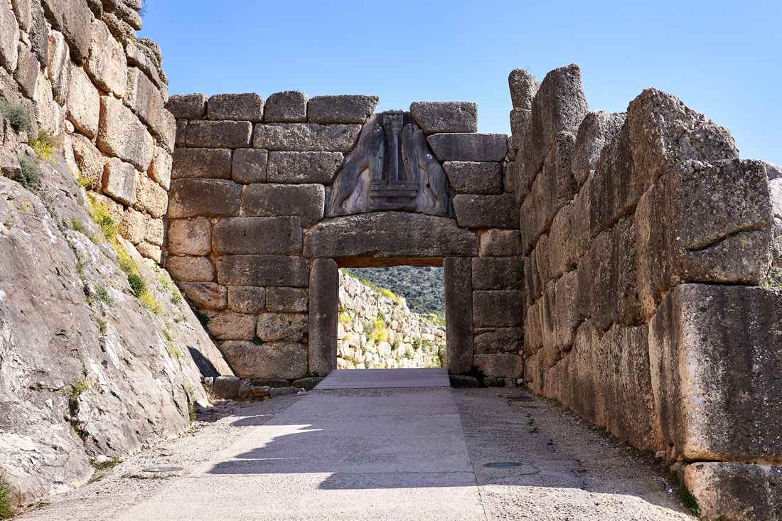
Mycenae is an archaeological site near Mykines in Argolis, in the north-eastern Peloponnese. In the second millennium BC it was one of the major centres of Greek civilization. The Lion Gate and the Treasury of Atreus are its noteworthy architecture. Linear B tablets there preserve the earliest examples of the Greek language.
Epidaurus was a small city on the Argolid Peninsula at the Saronic Gulf. Its healing sanctuary of Asclepius held a guest house with 160 guest rooms. The ancient theatre, designed by Polykleitos the Younger in the 4th century BC, still hosts dramatic performances. It began with 34 rows, and Roman builders added another 21.
Argolis has its seat in Nafplio, a coastal city on the Argolic Gulf. Its old town sits on a peninsula that juts into the gulf. Nafplio was the first official capital of independent Greece. Palamidi Fortress and Bourtzi Castle appear among its landmarks.
Mycenae, Epidaurus and Nafplio all lie in the regional unit of Argolis, so this Greece travel guide groups them together. For the ruins themselves, the ancient Greek ruins guide covers the visiting side.
Olympia is a small town in Elis, in the west of the peninsula. The Greece travel guide route turns there after the Argolid.
The nearby archaeological site hosted the ancient Olympic Games every four years. The games began in the 8th century BC and ended in the 4th century AD. The sacred precinct, the Altis, was dedicated primarily to Zeus. Its main buildings were the Temple of Hera, the Temple of Zeus and the Pelopion.
Antipater of Sidon named the statue of Zeus by Pheidias as one of the Seven Wonders. It was made of ivory and gold on a wooden frame. The stadium field gave its length to the stadion, an ancient Greek measure of distance.
The Greece travel guide moves south to Mystras. It is a fortified town in Laconia, set in the Taygetus range above ancient Sparta. Under Byzantine rule, Mystras was the capital of the Despotate of the Morea. That period fell in the 14th and 15th centuries. Constantine XI Palaiologos ruled Mystras as despot before he became the last Byzantine emperor.
Monemvasia is a town in Laconia on a tied island, close to the eastern shore of the Peloponnese. A tombolo joins the island to the mainland. The plateau stands about 100 metres above sea level, up to 300 metres wide and 1 kilometre long. The Italian form of its name, Malvasia, gave the Malvasia wine its name.
This Greece travel guide counts Laconia twice, with Mystras above ancient Sparta and Monemvasia on its rock. The town was founded in the sixth century. Europe counts it among its oldest continually inhabited fortified towns. It has been nicknamed the Gibraltar of the East.
The Greece travel guide reaches the Mani next, the central one of three peninsulas that extend south from the Peloponnese. Its tip is Cape Matapan, which is the southernmost point of continental Greece. Its towns include Areopoli, Gytheio and Pyrgos Dirou. The Apidima Cave holds Neanderthal fossils, and the tower-houses gave the region the name Maina Polypyrgos.
Pylos is the Messenia stop in this Greece travel guide. The town is the main harbour on the Bay of Navarino. The remains of the so-called Palace of Nestor lie nearby, from a significant kingdom of Mycenaean Greece. The Ottomans built the New Navarino fortress at the town. Pylos is the seat of the municipality of Pylos-Nestoras.
Kalamata is the capital and chief port of Messenia, on the Nedon River at the head of the Messenian Gulf. By population it is the second-largest city of the peninsula, after Patras. Kalamata is renowned as the land of the Kalamatianos dance, Kalamata olives and Kalamata olive oil. Pylos and Kalamata both belong to Messenia.
Patras is the regional capital and the largest city of Western Greece. It ranks third among Greek cities by size. It stands at the foot of Mount Panachaikon and overlooks the Gulf of Patras. Its port is a nodal point for trade with Italy. Christian tradition names it as the place of the martyrdom of Saint Andrew.
Patras hosts one of Europe’s largest carnivals every February. The city belongs to Western Greece. A Greece travel guide to the peninsula crosses a regional border to reach it.
Ancient Corinth closes the Greece travel guide tour of the Peloponnese. It was a city-state on the Isthmus of Corinth, roughly halfway between Athens and Sparta. It had a population of 90,000 in 400 BC.
In 146 BC the Romans destroyed the city. A new city rose there in 44 BC, and it later became capital of the province of Achaea.
The Temple of Apollo at Corinth was built in the Doric order. It stood on 38 columns, 7 of which are still in place. In Corinthian myth, the Isthmus belonged to Poseidon and the acropolis, Acrocorinth, belonged to Helios.
Where does Central Greece fit in a Greece travel guide?
Central Greece, called Sterea Ellada in Greek, is the traditional mainland region. It lies north of the Peloponnese and south of Thessaly and Epirus. The modern administrative region has Lamia as its capital and Chalcis as its largest city.
A Greece travel guide has to separate two meanings of the name. The traditional geographic region is also called Roumeli. Its territory is now split among Attica, Aetolia-Acarnania (part of Western Greece) and the administrative region of Central Greece.
The administrative region splits into five units: Phthiotis, Boeotia, Phocis, Evrytania and the island of Euboea. It borders Attica and the Peloponnese to the south, Western Greece to the west and Thessaly to the north. Euboea is the island unit. The Euripus Strait cuts it off from Boeotia and is only 40 metres wide at its narrowest point.
In a Greece travel guide, the Greek name Sterea Ellada reads as “Continental” or “Mainland” Greece. It sets this territory against the Peloponnese across the Gulf of Corinth. The older name Roumeli comes from the Turkish Rum-eli, “the land of the Rum”, meaning the Byzantine Greeks.
The geographic region covers 24,818 square kilometres. That makes it the second-largest geographic region of the country after Greek Macedonia. Any Greece travel guide notes that the climate is temperate along the coast and dry in the interior. Its elevations are among the highest in the country.
Each unit in this Greece travel guide has its own seat and relief:
- Phthiotis has Lamia as its capital and covers both shores of the Malian Gulf.
- Boeotia has Livadeia as its capital and Thebes as its largest city.
- Evrytania has Karpenisi as its capital and is formed almost entirely of mountains.
- Phocis stretches from the western slopes of Parnassus to the Vardousia range on the Gulf of Corinth.
- Aetolia-Acarnania has Missolonghi as its capital and Agrinio as its biggest city. It is the largest regional unit of Greece by area.
The ancient Amphictyonic League was an association of Greek tribes with twelve founders. It protected the temples of Apollo at Delphi and of Demeter near Thermopylae. The Acheloos in Aetolia-Acarnania is the second-longest river of the country, and the Spercheios flows through Phthiotis.
Which places in Central Greece belong in a Greece travel guide?
Delphi, Arachova, Thermopylae, Livadeia, Lamia, Nafpaktos, Missolonghi and Karpenisi anchor the region. Delphi was an ancient oracle seat and Thermopylae a narrow pass. Missolonghi is the town of a dramatic siege, and Karpenisi a mountain town with a ski resort.
A Greece travel guide to this region starts with Delphi, an ancient sacred precinct. It was the seat of the Pythia, the major oracle consulted about important decisions across the classical world. The precinct occupies the south-western slope of Mount Parnassus. A small modern town of the same name stands next to it.
In Greek belief, Delphi stood at the centre of the world. A stone monument, the Omphalos, marked the spot, and omphalos is the Greek word for navel. Greek National Road 48 links the town with Amfissa to the west and Livadeia to the east.
Arachova is a mountain town in the western part of Boeotia, on the southern slope of Mount Parnassus. It stands at an elevation of 970 metres above the Pleistos valley and lies 8 km east of Delphi. In a Greece travel guide, Arachova counts as a day or weekend trip destination from Attica.
Formaela cheese from Arachova holds protected designation of origin status. The town keeps local customs and marks its patron, Saint George, on 23 April. The Parnassos Ski Centre lies to the north.
Thermopylae means “hot gates”, a name taken from the sulphur springs that still flow at the foot of the hill. It is a narrow pass and a modern town in Lamia, Phthiotis. In Greek mythology, one entrance to Hades lay here.
Greek forces held this pass against the Persian army of Xerxes in a battle of the Greco-Persian Wars. The A1 motorway runs along the line of the old coast and cuts the pass in two. A modern monument to King Leonidas I of Sparta stands on the east side of the highway.
The ground of that battle now lies under 20 metres of soil, because the river Spercheios keeps depositing sediment. A Greece travel guide can use this fact to explain why the pass looks wide today.
Livadeia is the capital of the Boeotia regional unit, 90 km north-west of Athens. Any Greece travel guide to Boeotia names it as the seat. In antiquity the town rose to importance through its celebrated oracle of Trophonius. The area around it is mountainous, and farming is confined to the valleys.
Lamia is the capital of Phthiotis and of the Central Greece administrative region. A Greece travel guide treats it as the regional seat. The city climbs the slopes of Mount Othrys beside the river Spercheios. The city is the farming hub of the fertile countryside and livestock land around it. Excavations show people lived on the site since at least the Bronze Age.
Nafpaktos sits on a bay on the north coast of the Gulf of Corinth. Its ancient name, Naupaktos, means “boatyard”. The Venetians called the town Lepanto. It is the site of the decisive victory by the Holy League in the Battle of Lepanto.
The port of Nafpaktos holds monuments to that battle and a statue of Miguel de Cervantes. The harbour and the castle keep Venetian remains. Administratively the town belongs to Western Greece, yet this Greece travel guide places it in the traditional Central Greece.
Missolonghi is the capital of Aetolia-Acarnania and is known for a dramatic siege during the Greek War of Independence. The death of the poet Lord Byron is tied to that siege. The town has a port on the Gulf of Patras and lies between the Achelous and Evinos rivers.
Its name comes from Italian words meaning “in the middle of lakes”. The Missolonghi-Aitoliko Lagoons complex lies to the west. For wider protected areas, read our guide to nature reserves in Greece.
North-west of the town lie the remains of Pleuron, a town mentioned in the works of Homer. The theatre and an enormous water tank with four compartments still exist. Pleuron gives a Greece travel guide an ancient stop beside the lagoons.
Karpenisi is the capital of Evrytania. The town sits in the Karpenisiotis river valley, in the southern part of the Pindus range. Mount Tymfristos stands right to the north. Karpenisi has a ski resort and draws visitors especially in winter.
The name comes from the Aromanian word karpinu, meaning hornbeam. In antiquity the town was known as Oechalia and ruled by King Evrytos, the inventor of the bow. The road EO38 crosses Evrytania through Karpenisi. A Greece travel guide can treat it as the mountain base of the region.
How does a Greece travel guide define Thessaly?
A Greece travel guide describes Thessaly as a region in northern central Greece, and Larissa is its capital. Macedonia lies to the north and Epirus to the west. Central Greece lies to the south and the Aegean Sea to the east.
Thessaly joined the modern Greek state after four and a half centuries of Ottoman rule. Today it is one of the 13 regions of Greece. It has five regional units and 25 municipalities.
The units are Larissa, Magnesia, Trikala and Karditsa, plus a fifth made of islands. That island unit has its own part in this Greece travel guide.
The relief in a Greece travel guide starts in the north, with a spur of the Pindus range. Within that broken spur lie basins and river valleys. The spur ends in the Magnesia Peninsula, which wraps around the Pagasetic Gulf, also called the Gulf of Volos.
The Trikala and Larissa lowlands form a central plain, and a ring of mountains surrounds it. The Chasia and Kamvounia mountains lie to the north and the Pindus range to the west. The coastal mountains of Ossa and Pelion close the southeast.
Summer rains add to the fertility of the plain, and Thessaly is sometimes called the “breadbasket of Greece”. The Pineios is the major river of the region. It flows east from the central Pindus range.
The alluvial soils of the Pineios basin make Thessaly a vital farming area for grain, cattle and sheep. A Greece travel guide can add that Thessaly is the leading cattle-raising area of Greece. Aromanian shepherds move large flocks of sheep and goats between higher and lower ground with the seasons.
Almond, pistachio and walnut trees are on the rise around the town of Almyros. Larissa is the seat of the region, and its metropolitan area is home to more than 230,000 people. The Gulf of Pagasai gives the plain a natural harbour at Volos for shipping farm produce.
The region also appears in myth. Before the Greek Dark Ages, Thessaly was known as Aeolia, and it appears in Homer’s Odyssey under that name. In legend, Jason and the Argonauts set out from the Magnesia Peninsula to search for the Golden Fleece.
The Plain of Thessaly was also the site of the battle between the Titans and the Olympians. Each Greece travel guide that retells Greek myth gives the plain a role in that story.
Which places in Thessaly belong in a Greece travel guide?
For Thessaly the guide names Meteora and Kalabaka, Volos and the Pelion peninsula, Larissa and Trikala. Lake Plastiras sits at the edge of the plain in the Karditsa unit. Each place has its own role on the map.
Meteora is a rock formation in the Trikala regional unit. Twenty-four monasteries were founded on its pillars, mainly from the second half of the 14th century. Four are in active use and open to visitors: Great Meteoron, Varlaam, Holy Trinity and Saint Stephen.
The pillars are made of sandstone and conglomerate, not of volcanic rock. Meteora sits between the town of Kalabaka and the village of Kastraki. Its name means “lofty” or “elevated”. Any Greece travel guide to Thessaly starts the monastery section here.
Kalabaka is the seat of the municipality of Meteora, and the monasteries stand near the town. Its name comes from Turkish and means “powerful fortress”. A Greece travel guide meets Kalambaka and Kalampaka as other spellings of the same name.
In the 10th century the town was a Byzantine fortress and bishopric called Stagoi. One medieval monument survives: the Church of the Dormition, a cathedral from the late 11th or early 12th century.
Volos is a port city and the capital of the Magnesia regional unit. Athens lies 170 km to its south and Thessaloniki 140 km to its north. Volos is Thessaly’s only outlet to the sea. The villages of Makrinitsa and Portaria belong to its municipality.
Modern Volos stands on the area of ancient Iolcos, the homeland of the hero Jason, who boarded the ship Argo. The Neolithic settlements of Dimini and Sesklo lie to the west of the city. A Greece travel guide can use Volos as the gateway to Pelion.
Pelion is a mountain in the southeast of Thessaly. Its hook-like peninsula separates the Pagasetic Gulf from the Aegean Sea. Beech, oak, maple and chestnut trees cover it thickly, and plane tree groves grow around places with water.
In Greek myth, the Centaur Chiron lived there and taught the heroes Jason, Achilles, Theseus and Heracles. The local dish is spentzofai, a stew of sliced pork sausage with peppers. Orchards on the mountain grow the firiki, a small, oval and fragrant apple.
Larissa anchors the plain in a Greece travel guide as the capital and largest city of Thessaly. The city straddles the Pineios river, and Mount Olympus and Mount Kissavos lie to its north and northeast. Ruins of the ancient city-state are among its main tourist attractions.
The first ancient theatre of Larissa rose inside the ancient city centre. Builders finished it towards the end of the 3rd century BC. It stayed in use for six centuries. In antiquity the fertile land around the city was known for its horses.
Trikala heads its regional unit and spreads across the Lithaios river, which feeds the Pineios. It lies close to Meteora and the southern Pindus mountains. Ancient Trikka stood on the same site. The city was considered the birthplace and main residence of the healing god Asclepius.
Lake Plastiras, also called the Tavropos Reservoir, is a man-made lake close to the city of Karditsa. The Tavropos river feeds it. The lake takes its name from the general and politician Nikolaos Plastiras.
The lake supplies water for irrigation and for a hydroelectric plant. It is also the main water source of the city of Karditsa. For quieter corners of the country beyond these towns, read about off the beaten path in Greece. A Greece travel guide to Thessaly closes on that note.
Why does a Greece travel guide cover Epirus?
Epirus is the northwestern region of Greece, covering about 9,200 square kilometres, with Ioannina as its capital. It faces the Ionian Sea in the west. Albania lies on its northern border.
Epirus borders Western Macedonia and Thessaly to the east and West Greece to the south. To the west lie the Ionian Sea and the island chain named after it. Albania lies to the north.
The land is rugged and mountainous. Mountain ridges that belong to the Dinaric Alps make up the bulk of it. In the east, the Pindus Mountains, the spine of mainland Greece, separate Epirus from Macedonia and Thessaly. A Greece travel guide to the northwest starts with this relief.
The greater part of Epirus lies on the windward side of the Pindus. Winds from the Ionian Sea give the region more rainfall than any other part of Greece. The climate is mainly alpine, and conifers dominate the vegetation.
Bears, wolves, foxes, deer and lynxes live in the region. The Greece travel guide entry for Epirus covers this wildlife too. The ancient Molossians and Thesprotians held this land, and the Thesprotians lived in its western part.
Epirus is both a traditional geographic region and a modern administrative region. Its four regional units are Thesprotia, Ioannina, Arta and Preveza. Ioannina is the seat of the whole region. This Greece travel guide chapter uses the city as its base.
Which places in Epirus belong in a Greece travel guide?
Ioannina, the Zagori villages, Metsovo, Dodona, Parga, Preveza, Igoumenitsa and the Bridge of Arta anchor the region. Each has its own feature. The list covers a lake city, stone bridges, a mountain town, an oracle, a seaside town and a harbour.
This Greece travel guide opens the place list with Ioannina, the capital and largest city of Epirus. It sits on the western shore of Lake Pamvotis, 436 kilometres northwest of Athens and 290 kilometres southwest of Thessaloniki. The port of Igoumenitsa lies 90 kilometres to the west.
Tradition credits the Byzantine Emperor Justinian with founding Ioannina in the 6th century. The city served as a power base for Ali Pasha under Ottoman rule. The Aslan Pasha Mosque, built on the site of a church of Saint John, now houses the Municipal Ethnographic Museum.
The Greece travel guide places Zagori in the Pindus mountains. It is a region with 46 villages, called the Zagori villages or Zagorochoria. Its seat is the village of Asprangeloi. Expatriate merchants paid for the arched stone bridges in the 18th century. These bridges linked the villages until modern roads opened in the middle of the 20th century.
A Greece travel guide entry for Metsovo starts with its position. The town lies in the Pindus mountains between Ioannina to the west and Meteora to the east. It is the largest centre of Aromanian (Vlach) life in Greece. Tourism flourishes there in winter, and the Metsovo Ski Centre lies near the town.
The town is known for its cheeses, Metsovone and Metsovela, and for the Katogi vineyard of the Averoff family. The Averoff Gallery is dedicated to Georgios Averoff, a benefactor who came from Metsovo.
Dodona was the oldest Hellenic oracle. The earliest accounts in Homer describe it as an oracle of Zeus. It ranked second only to Delphi in prestige. King Pyrrhus made it the religious capital of his domain in the 3rd century BCE. He added a festival with athletic games, musical contests and drama in a theatre.
Parga is a resort town on the Ionian coast between Preveza and Igoumenitsa. It passed under Venetian control in the 15th century. It stayed in Venetian hands, apart from brief Ottoman periods, until the Republic of Venice fell. The ancient town of Toryne stood nearby, and its name means ladle, after the shape of its beach.
Preveza lies on the northern peninsula at the mouth of the Ambracian Gulf. The Aktio-Preveza Immersed Tunnel links it to Aktio and is the only undersea tunnel in Greece. The ruins of the ancient city of Nicopolis lie 7 kilometres north of the town.
In the Greece travel guide, Igoumenitsa is the capital of Thesprotia and the chief port of Epirus. It is one of the largest passenger ports of Greece. Ferries link the northwestern mainland with the Ionian Islands and Italy. Readers who cross by sea can study Greek ferry booking tips before the trip.
The 670-kilometre A2 motorway, the Egnatia Odos, ends at Igoumenitsa. Drepanos Beach nearby is one of the longest sand beaches in the region, with a length of over 7 kilometres. This Greece travel guide entry for the port stays short, because the town works as a gateway.
This Greece travel guide closes with the Bridge of Arta, a stone bridge over the Arachthos river. It stands in the west of the city of Arta. Wikipedia dates the current bridge to the Ottoman period, in the 17th century. A folk ballad tells how the foundations collapsed each night during the building. The ballad gave Greek speech proverbs about endless delays.
From the annexation of Arta to the First Balkan War, the highest point of the bridge marked a border. It divided the Ottoman Empire from the Kingdom of Greece.
How is Macedonia laid out in a Greece travel guide?
Greek Macedonia is the largest geographic region of Greece and the second in population, with 2.36 million people. It sits in the southern Balkans, in Northern Greece, and forms the border with Albania, North Macedonia and Bulgaria. A Greece travel guide opens its northern chapter here.
The region is highly mountainous. Its larger towns, such as Katerini and Kavala, cluster along the southern coastline. Thessaloniki is the capital of Central Macedonia. A Greece travel guide to this area reads as a map of three administrative parts.
Western Macedonia covers north-western Greece and holds the units of Florina, Grevena, Kastoria and Kozani. Central Macedonia is the central part. The eastern part belongs to the region of Eastern Macedonia and Thrace.
Greek Macedonia takes in the core of the ancient kingdom of Macedon. The Argead dynasty ruled that kingdom, and Alexander the Great and his father Philip II sat among its rulers. The southern part of the region joined the Greek state after the Balkan Wars and the Treaty of Bucharest.
The region also carries economic weight. Macedonia accounts for the majority of Greek agricultural production and adds to industry and tourism. Our Greece travel guide therefore treats it as a working region as well as a historic one.
One place in the region governs itself. The autonomous monastic community of Mount Athos answers to the Ministry of Foreign Affairs in political matters. In religious matters it answers to the Ecumenical Patriarch of Constantinople.
Which places in Macedonia belong in a Greece travel guide?
Halkidiki, Mount Athos, Vergina, Pella, Kastoria, Edessa, Kavala, Serres and Drama anchor a Greece travel guide of Macedonia. Each has a clear role. They are a peninsula, a monastic republic, two royal capitals, a lake town, a seaport and three inland cities.
Halkidiki is a peninsula and regional unit in coastal Macedonia. Its capital is Polygyros, in the centre, and its largest town is Nea Moudania. The land resembles a hand with three fingers, called Kassandra, Sithonia and Athos. Sithonia rises to Mount Itamos at 817 metres. Every Greece travel guide to the north lists this hand.
Mount Athos is a mountain on the Athos peninsula in northeastern Greece, directly on the Aegean Sea. It is a centre of Eastern Orthodox monasticism. The monastic community governs the mountain and the peninsula as an autonomous region. By Greek law and religious tradition, women are prohibited from entering that area.
Vergina is a small town in the Veroia municipality of Imathia. It is the site of ancient Aigai, the first capital of Macedon, where Philip II was assassinated in the theatre. Researchers uncovered three tombs there, and the archaeological museum of Vergina houses the finds from the site.
Pella lies 1 km outside the modern town of the same name. It was the capital of the ancient kingdom of Macedon from the 4th century BC until the Roman conquest. Philip II and Alexander the Great were both born there. For the royal sites in a wider route, read our Greece historical tours page.
Kastoria sits on a promontory on the western shore of Lake Orestiada, in a valley ringed by limestone mountains. The name means “place of beavers”, from the Greek word kastori. The city is known for its Byzantine churches, its lake and its fur clothing industry. Doltso and Apozari are two traditional lakeside quarters.
Edessa is the capital of the Pella regional unit, in Central Macedonia. In Byzantine times it controlled the Via Egnatia where the road enters the Pindus mountains. Its economy now rests on services and tourism, drawn by ancient Pella, the waterfalls and winter sports. Each Greece travel guide to Macedonia covers these falls.
Kavala is the principal seaport of eastern Macedonia and the capital of the Kavala regional unit. It lies on the Bay of Kavala, across from the island of Thasos, and on the A2 motorway. Drama is 37 km to the north. The Ottomans extended the Byzantine fortress on the hill of Panagia.
Serres is the capital of the Serres regional unit. It stands on a fertile plain at an elevation of about 70 metres, 24 km north-east of the Strymon river. The city hosts a campus of the International Hellenic University, so the Greece travel guide reaches a student town here.
Drama is a city in northeastern Greece and the capital of its own regional unit. It is built at the foot of Mount Falakro, in a green area with abundant water. Under the Byzantine Empire it was a fortified city with a castle.
Drama hosts the “Eleftheria” events at the end of June or the start of July. It also holds an annual film festival in September. That calendar gives a Greece travel guide two dates to plan around.
What does Thrace add to a Greece travel guide?
Greek Thrace is the northeastern corner of the country, a historical region of mountain-enclosed basins and deep river valleys. Komotini is the seat of its administrative region, Eastern Macedonia and Thrace, and Alexandroupolis is its largest city.
Greek Thrace has three regional units: Xanthi, Rhodope and Evros. Evros includes the island of Samothrace. Drama, Kavala and Thasos, three units of Macedonia, join them to make up the region of Eastern Macedonia and Thrace. A Greece travel guide to the northeast starts from these three units.
The region is also called Western Thrace, because it is the western part of the wider region of Thrace. The European part of Turkey is Eastern Thrace. The Aegean Sea bounds Greek Thrace to the south. The Nestos river bounds it to the west and the Evros river to the east.
In a greece travel guide, the relief reads as basins ringed by mountains and deep river valleys. The Rhodope Mountains form the mountainous northern part. They hold one of the two surviving brown bear populations in Greece. The other lives in the Pindus range of central Greece.
The name Thrace comes from ancient Greek Thrake. It referred first to the Thracians, an ancient people of Southeast Europe. In Greek mythology, the region is named after the heroine Thrace, a daughter of Oceanus and Parthenope. The name is older than the modern region.
Alexandroupolis is the capital of the Evros regional unit and the largest city of the whole region. Komotini is the capital of the Rhodope regional unit and of the region itself. Xanthi is the capital of the Xanthi regional unit, so a greece travel guide lists it as a third base. Three capitals give the Thrace chapter of a greece travel guide three bases.
Which places in Thrace belong in a Greece travel guide?
Alexandroupolis, Komotini, Xanthi, Orestiada, Maroneia, the Evros delta and Dadia forest anchor the Thrace chapter. The Rhodope range frames them all in a greece travel guide, and each place below comes with one sourced fact.
Alexandroupolis is a port city and a commercial centre of Northern Greece. Its landmarks include the lighthouse in the port, the waterfront and the Ethnological Museum of Thrace. Local folk tradition names a cave in nearby Makri as the cave of the Cyclops Polyphemus. A Greece travel guide to Evros starts here.
Komotini is home to the Democritus University of Thrace. It sits 281 km northeast of Thessaloniki. Ruins of a Byzantine fortress built by the Emperor Theodosius in the 4th century stand northwest of the central square. The city has an Archaeological Museum, a Byzantine Museum and a Folklore Museum.
Xanthi is built on the foot of the Rhodope Mountains and is split by the Kosynthos River. Its old town, called Palia Poli, joins Byzantine Greek churches, neoclassical mansions of merchants and Ottoman-era mosques. Two monasteries there date from the Middle Ages. The guide on how to visit Greek monasteries covers the manners for such sites. A Greece travel guide that stops in Xanthi has to include them.
Over 40 cultural associations from around Greece join the spring carnival in Xanthi. The programme holds concerts, theatre plays, exhibitions, a cycling event and re-enactments of old customs. The Archaeological Museum of Abdera also stands in the town.
Orestiada is the northeasternmost, northernmost and newest city of Greece. Greek refugees from Edirne founded it after the population exchange between Greece and Turkey. A legend says that Orestes, the son of Agamemnon, founded the older settlement of Orestias on this site. It lies in the plain of the Evros river, 40 metres above sea level.
Maroneia is a village in the Rhodope regional unit. In legend, Maron, a son of Dionysus, founded it. In ancient Greece and Rome the town was known for its wine. The foundations of its Dionysian sanctuary can still be seen. Today the settlement stands on the hillside of Mount Ismaros.
The Evros delta lies about 14.5 km east of Alexandroupolis. It is listed under the Ramsar Convention for its rare plants and animals. It holds more than 300 plant species, 46 fish species, 28 reptile species and 320 bird species. A Greece travel guide for nature lovers lists the delta beside Dadia.
The Dadia forest is a large woodland of oak and pine in the Evros regional unit. No other forest in Europe holds all four native European vultures. They are the black, bearded, Egyptian and griffon vulture. Cars are not permitted inside. Visitors follow trails on foot or join minibus ecotours. A greece travel guide for birdwatchers names it first.
The Rhodope range is a mountain range in Southeastern Europe. Over 83% of its area lies in southern Bulgaria and the remainder in Greece. Its name has Thracian origin. In myth, Queen Rhodope offended the gods, and Zeus and Hera turned her into a mountain.
Samothrace, a Greek island in the northern Aegean Sea, belongs to the Evros regional unit.
How does a Greece travel guide treat the Ionian Islands?
This Greek island group lies in the Ionian Sea, west of mainland Greece. Its traditional name is Heptanese, meaning “Seven Islands”. Its administrative region has Corfu as its capital and is the smallest of Greece’s thirteen regions by area.
A Greece travel guide counts seven principal islands in the group. Reading north to south, the list runs Corfu, Paxos, Lefkada, Ithaca, Kefalonia, Zakynthos, then Kythira. The group also includes smaller islands beyond those seven.
Six islands of the group sit close to the western coast of the Greek mainland. Kythira sits off the southern tip of the Peloponnese instead. It belongs to the Attica Region today, while the other six belong to the Ionian Islands Region.
The Ionian Islands Region splits into five regional units: Corfu, Ithaca, Kefalonia, Lefkada and Zakynthos. Paxos sits inside the Corfu regional unit, so a Greece travel guide places the two islands side by side.
The name comes from myth. The adjective Ionios described the sea between Epirus and Italy because, according to myth, Io swam across it. The Ionian Sea and its islands are not related to Ionia, a region in Anatolia.
Venetian rule shaped the islands as a distinct historic region. It kept them outside Ottoman control and left a cultural identity with Italian influences. The group became part of the modern Greek state in the 19th century.
Venetian rule also gave the islands Italian names. Kerkyra became Corfù, Zakynthos became Zante, Lefkada became Santa Maura, Kythera became Cerigo and Ithaki became Val di Compare.
The weather and the crowds change with the season. The page on when to visit Greece covers both before a Greece travel guide turns to route planning.
Which places in the Ionian Islands belong in a Greece travel guide?
Each of the seven principal islands has a named draw. Corfu Town has Venetian fortresses, Paxos has olive groves, Lefkada has a causeway and Ithaca has Homer. Kefalonia has Mount Ainos, Zakynthos has sea turtles and Kythira has blended architecture.
Corfu lies in the northwestern corner of Greece, and its northeastern edge faces the Albanian coast. Its shape resembles a sickle. A Greece travel guide opens with Corfu Town, the seat of the whole region. Narrow lanes and multi-storied buildings show Venetian influence.
Venetian nobility ruled Corfu Town from the 14th century to the 18th century. The city went through four notable sieges, and its powerful Venetian fortifications held each time. Its two castles gave it the name Kastropolis, meaning Castle City.
A Greece travel guide marks Liston, a multi-level building with an arched colonnade. Cafes and restaurants line its east side. It stands at the edge of the Spianada, the main plaza and park. The Spianada holds a cricket field. Cricket arrived on Corfu during British rule.
Outside the town, the Achilleion stands in the village of Gastouri, south of the city. Empress Elisabeth of Austria built the summer palace in the 19th century and named it after the hero Achilles. Paintings and statues of Achilles fill the hall and the gardens.
A Greece travel guide calls Paxos the smallest of the seven main Ionian Islands. It lies 15 kilometres south of Corfu. Its main town and municipal seat is Gaios. Olive groves cover much of the hilly landscape. They run between the harbour village of Lakka and the capital Gaios. Steep white chalky cliffs mark the west coast.
Antipaxos is a small island south of Paxos, largely covered in vineyards. It has three main beaches: Vrika, Mesovrika and Voutoumi. A sea taxi from the port of Gaios reaches it in 15 minutes. A Greece travel guide files Antipaxos next to Paxos.
Lefkada joins the mainland by a long causeway and a floating bridge. The principal town, also called Lefkada, sits in the north. Nidri is the largest resort and looks across to Skorpios and Meganisi. Vasiliki is a windsurfing centre.
Cape Lefkada lies south of Vasiliki. Legend says the poet Sappho leapt from its 30-metre cliffs. The beach of Porto Katsiki lies on the west coast. A Greece travel guide adds Lefkada to the list for these cliffs and bays.
Ithaca, also spelled Ithaki, sits northeast of Kefalonia, divided from it by a narrow channel. Vathy is its capital and largest settlement. Modern Ithaca is identified with Homer’s Ithaca, the home of Odysseus in the Odyssey, although other islands have been proposed.
The narrow isthmus of Aetos joins the two halves of Ithaca. Polis Cave, near Stavros in the north, was identified by an early archaeologist as a cave Odysseus visited. Frikes and Kioni are bays on the northeast coast.
In a Greece travel guide, Kefalonia leads the group by size. Argostoli is its seat, and Lixouri is the other large town. Four city-states once shared the island: Pale, Cranii, Same and Pronnoi, which match today’s Lixouri, Argostoli and Sami.
According to the ancient writer Strabo, Mount Ainos held a sanctuary of Zeus Ainesios. The Venetians built Assos Castle in the 16th century, and it is one of the main tourist attractions today. A series of four earthquakes in the 20th century destroyed virtually every house on the island.
Zakynthos, also called Zante, ranks third by size among the Ionian Islands. The Venetians gave it the nickname Fiore di Levante, meaning Flower of the East. A Greece travel guide describes its shape as an arrowhead, with Cape Skinari at the tip pointing northwest.
The western half of Zakynthos is a mountainous plateau, and the southwest coast is mostly steep cliffs. The eastern half is a fertile plain with long sandy beaches. Bochali hill above Zakynthos town holds a small Venetian castle.
The Bay of Laganas is the site of the first National Marine Park. It is the prime nesting area for loggerhead sea turtles in the Mediterranean.
Kythira lies opposite the southeastern tip of the Peloponnese, between the Greek mainland and Crete. Its architecture blends traditional, Aegean and Venetian elements. The chief town is Kythira, also called Chora. A Greece travel guide lists the island with the seven even though it sits far from the main group.
Saint Theodore of Cythera established a great monastery at Paliochora, and a town grew up around it. Barbarossa later destroyed and looted that town, and its ruins remain. The Fonisa Waterfall stands at Mylopotamos.
What makes the Cyclades a chapter of a Greece travel guide?
An archipelago in the Aegean Sea, southeast of the Greek mainland, with about 220 islands. The name means the islands that form a circle around Delos, an island that was sacred in ancient Greek religion.
In a Greece travel guide, the group sits north of the Sea of Crete, which bounds it to the south. Ermoupoli on Syros is the chief town and the administrative centre of the former prefecture. Syros also has the largest population of the group.
The islands are the peaks of a submerged mountainous terrain. Only two of them are volcanic: Milos and Santorini. The climate is dry and mild. With the exception of Naxos, the soil is not very fertile. The farms produce wine, fruit, wheat, olive oil and tobacco.
The Late Neolithic and Early Bronze Age Cycladic culture is known for schematic, flat sculptures carved from pure white marble. They were made centuries before the Minoan civilization rose on Crete. The Harp player, an example of Cycladic art, is kept at the National Archaeological Museum in Athens.
The former prefecture is now split into nine regional units of the South Aegean region. They are Andros, Kea-Kythnos, Milos, Mykonos, Naxos, Paros, Thira, Syros and Tinos.
Tourism has grown in recent decades. With it came problems with erosion, pollution and water shortages.
Which places in the Cyclades belong in a Greece travel guide?
Twelve islands carry the group: Santorini, Mykonos, Naxos, Paros, Milos, Syros, Tinos, Andros, Ios, Amorgos, Sifnos and Folegandros. Each one below carries a single named sight.
A Greece travel guide to the group opens with Santorini. Its caldera shaped a small ring of islands, and this is the biggest piece of that ring. At Akrotiri, a Bronze Age town lies under volcanic ash. Its wall paintings kept their original colour because metres of ash preserved them.
For a Greece travel guide, Mykonos has the nickname Island of the Winds. In the Kastro quarter, the church of Panagia Paraportiani stands next to the entrance of the old castle. It took around 200 years to build.
The Greece travel guide entry for Naxos starts with Mount Zeus, the highest peak in the Cyclades. Myth says the young Zeus was raised in a cave on Mount Zas. Paros gave its name to Parian marble, the fine white stone. Its capital, Parikia, stands on the site of the ancient capital.
Milos is volcanic. The Venus de Milo statue came from this island and stands in the Paris Louvre today. Plaka is the chief town, and Kastro rises on a hill above it.
Ermoupoli on Syros was built during the Greek War of Independence. Neoclassical buildings and white houses cascade down to the harbour. Ano Syros, built by the Venetians at the beginning of the 13th century, is reached by marble steps.
In a Greece travel guide, Tinos stands for the Church of Panagia Evangelistria. It houses an icon of the Virgin Mary. Pilgrims gather there every year on 15 August, the feast of the Dormition. The island also has about 1,000 artistic dovecotes.
No other Cyclades island reaches as far north as Andros. Palaeopolis, the old capital, rose up a sloping hill. The breakwater of its harbour can still be seen underwater.
Ios lies halfway between Naxos and Santorini. Its Chora has whitewashed architecture, narrow alleys and steep stairways, which make it largely inaccessible to cars. Amorgos is the easternmost island of the group. The monastery of Panagia Hozoviotissa stands on a cliffside northeast of Chora and was built to protect an icon.
Sifnos has rich clay veins, and its pottery is a trademark of the island. Kastro, the ancient capital, is built on top of a high cliff on the east shore. Folegandros is small, with three villages: Chora, Karavostasis and Ano Meria. Chora is built on the edge of a cliff.
Chain two or three of these islands into one trip with a plan for Greek island hopping. Any Greece travel guide to the Cyclades gains from giving each island its own day.
Where do the Dodecanese sit in a Greece travel guide?
Fifteen larger and 150 smaller islands lie in the southeastern Aegean Sea off the coast of Anatolia. Twenty-six of them have residents. Rhodes is the largest of them and the historical capital of the group.
A Greece travel guide places the Dodecanese in the southeastern Aegean. Turkey borders the group in the east, Crete in the southwest and the Cyclades in the west. In Greek the name means “twelve islands”. The group belongs to the wider Southern Sporades.
This Greece travel guide starts with Rhodes, the dominant island since antiquity. Of the others, Kos and Patmos carry the greatest historical weight. The remaining islands include Astypalaia, Kalymnos, Karpathos, Leros, Nisyros, Symi and Tilos.
A Greece travel guide records a hot-summer Mediterranean climate with mild winters across the group. Karpathos, Kasos and Nisyros are the exceptions, with a hot semi-arid climate. The highest mean annual sunshine in Greece falls on South East Rhodes, with more than 3,100 hours.
The relief of the Dodecanese changes from island to island. Mount Attavyros, at 1,216 metres, is the highest point of Rhodes. Kali Limni on Karpathos reaches 1,215 metres. Rhodes lies 363 km east-southeast of the Greek mainland. The coast of Turkey is 18 km away.
The city of Rhodes is the principal town of the largest island. Each smaller island has its own main town and harbour. A Greece travel guide treats each one as a separate stop.
Which places in the Dodecanese belong in a Greece travel guide?
Ten islands earn a place in this Greece travel guide. They are Rhodes, Kos, Patmos, Symi, Karpathos, Leros, Kalymnos, Astypalaia, Nisyros and Tilos. Each one adds a different sight, from a walled medieval town to an active volcano crater. One sourced fact for each follows.
- Rhodes: the medieval Old Town sits inside a wall 4 km long. The Knights built the Palace of the Grand Master during their rule.
- Lindos: this fishing village on the east coast of Rhodes lies about 40 km south of Rhodes city. Its acropolis carried the temple of Athena Lindia in classical times.
- Kos: the third largest island of the Dodecanese measures 42.1 by 11.5 kilometres. In antiquity it hosted the school of medicine founded by Hippocrates.
- Patmos: according to Christian belief, John of Patmos received the visions of the Book of Revelation in the Cave of the Apocalypse, halfway up the mountain between Chora and Skala.
- Symi: the island once had the largest sponge fishing fleet in the world. Neoclassical mansions on the slopes near the main town date from its mid-19th-century peak.
- Karpathos: the second largest island of the group sits 47 km southwest of Rhodes. Its remote location preserved local dress, customs and dialect.
- Leros: the island is known for its imposing medieval castle, linked to the Knights of Saint John. The largest town, Agia Marina, serves as the administrative centre.
- Kalymnos: the island is billed as the sponge-divers’ island. It also has more than 4,600 climbing routes set in limestone.
- Astypalaia: the town of Chora occupies the hill crowned by the Querini castle. A band of land 126 metres wide nearly splits the island in two at Steno.
- Nisyros: this volcanic island has a caldera 3 to 4 kilometres wide. Fumaroles are found at the craters.
- Tilos: the island lies midway between Kos and Rhodes. Remains of a dwarf elephant species were found in Charkadio cave.
The history in a Greece travel guide for these islands has two layers. The Knights of St John arrived in the early 14th century and built castles on Rhodes, Leros, Tilos and Nisyros. Their rule on Rhodes ended when Suleiman the Magnificent’s army took the citadel after a siege.
The Italian layer of this Greece travel guide begins with the Italo-Turkish War. Astypalaia was the first island of the group that Italy occupied, and a landing on Rhodes followed. On Kos, Italian planners turned the old quarters into an archaeological park after a ruinous earthquake. The islands joined Greece after the Second World War.
Gialos, the port of Symi, is a popular marina for sailors. For boat travel across the wider country, read the guide to sailing holidays in Greece.
How does a Greece travel guide introduce the North Aegean Islands?
This island group lies scattered across the north-eastern Aegean Sea. Visitors and administrators group the islands together, although they form no physical chain. The North Aegean region holds the larger share, and its capital is Mytilene on Lesbos. This Greece travel guide starts with that map.
The islands do not form a chain or a single cluster. The Dodecanese lie to the south, and the Cyclades and Sporades lie to the west. Turkey’s coast sits close by, across narrow waters such as the Mytilini Strait, the Chios Strait and the Mycale Strait.
The North Aegean region has five regional units: Chios, Ikaria, Lemnos, Lesbos and Samos. A Greece travel guide treats these five as the core of the group. The region counts nine islands in all, including Psara, Oinousses, Agios Efstratios and Fournoi Korseon.
Mytilene, on Lesbos, is the regional capital. The Decentralized Administration of the Aegean, based at Piraeus, supervises the region together with the Southern Aegean.
Two northern islands sit outside the region. Thasos and Samothrace belong to Eastern Macedonia and Thrace. Imbros and Tenedos belong to Turkey.
The relief changes from island to island. Lemnos is mainly flat, with rocky and mountainous ground in the northwest. Chios has a ridge of mountains along its length. Samos is dominated by two large mountains, Ampelos and Kerkis. Ikaria is crossed from east to west by the Aitheras range.
Which places in the North Aegean Islands belong in a Greece travel guide?
Lesbos, Chios, Samos, Ikaria, Lemnos, Samothrace, Thasos and Fournoi Korseon make the core list. Each has one clear draw: poets, mastic villages, an ancient town, a mountain range, a volcanic myth or a sanctuary.
Lesbos is nicknamed the Island of the Poets. Sappho and Alcaeus, two of the nine lyric poets of the Ancient Greek canon, were born there. Mytilene is its capital and largest city. The island also holds a petrified forest, declared a Protected Natural Monument.
Chios is nicknamed the Mastic Island for its exports of mastic gum. A Greece travel guide to Chios names the seven Mastichochoria villages in the south. They are Mesta, Pyrgi, Olympi, Kalamoti, Vessa, Lithi and Elata. They have controlled mastic production since the Roman period.
Builders raised the mastic villages in the 14th to 16th centuries. Their fortified gates and narrow streets protected them from pirate raids.
For a Greece travel guide, Samos starts with Pythagoreion, the archaeological site of the ancient town of Samos. The site has fortifications from the 5th and 4th centuries BC, a Roman agora, public baths and a stadium. It also has the Tunnel of Eupalinos. Pythagoras was born on Samos.
Ikaria lies 19 kilometres southwest of Samos. Tradition says its name comes from Icarus, who fell into the sea nearby. Agios Kirykos is the main port, and Evdilos is the secondary port. The Raches region in the west holds traditional settlements and cultural events. Our guide to Greek festivals covers the wider calendar.
A Greece travel guide to Lemnos starts with its position, halfway between Mount Athos and the west coast of Turkey. Myrina, also called Kastro, is its principal town. Ancient Greeks held the island sacred to Hephaestus. Strong winds earned it the nickname “the wind-ridden one”.
Samothrace is a rugged island, and its highest peak is Mount Fengari. This Greece travel guide places it in Thrace, not in the North Aegean region. The island was home to the Sanctuary of the Great Gods, where the Samothracian Mysteries took place. The Winged Victory of Samothrace statue was found here and now stands in the Louvre.
Thasos, the northernmost major Greek island, has its capital at Limenas on the north coast.
Fournoi Korseon lies southeast of Ikaria and counts among the nine islands of the North Aegean region.
What are the Sporades and Euboea in a Greece travel guide?
A Greece travel guide treats the Northern Sporades and Euboea as two neighbours in the western Aegean. The Sporades are an archipelago of 24 islands, four of them permanently inhabited. Euboea is one long island tied to the mainland by bridges.
The name Sporades means “those scattered”. The group lies along the east coast of mainland Greece, northeast of Euboea. The four inhabited islands are Skiathos, Skopelos, Alonnisos and Skyros. The Sporades regional unit covers Skiathos, Skopelos and Alonnisos and sits in the region of Thessaly.
The regional unit has three municipalities, one for each of those islands. Skyros and the uninhabited islets around it belong to the Euboea regional unit instead. That regional unit sits in Central Greece, so a Greece travel guide files Skyros with Euboea on the administrative map.
A Greece travel guide sizes Euboea first. Also called Evia, it ranks second among Greek islands by area, behind Crete. It is about 180 kilometres long and runs from northwest to southeast. A mountain range crosses it along its whole length. Its breadth varies from 50 kilometres down to 6 kilometres.
The Euripus Strait separates Euboea from Boeotia on the mainland. Chalkis, the chief city of the island, sits at the narrowest point of the strait. Two road bridges cross the channel, both at Chalkis. A sliding bridge spans the narrowest point in the middle of town, and a cable-suspended bridge stands to the south.
The strait has strong tidal currents that reverse direction about four times a day. The water flow peaks at about 12 kilometres an hour. Smaller vessels cannot sail against it. A Greece travel guide can use the Euripus as the one natural landmark that separates island from mainland.
Euboea divides into three parts. The north is fertile and forested, the centre is forested and mountainous, and the south is barren. The main mountains include Dirfi at 1,743 metres and Ochi at 1,394 metres in the south.
Which places in the Sporades and Euboea belong in a Greece travel guide?
Nine places anchor the region. Skiathos, Skopelos, Alonnisos and Skyros lie in the Sporades. Chalkis, Eretria, Karystos, Limni and Edipsos lie on Euboea. Each has one sourced fact below, from island size to the ferry route.
A Greece travel guide opens the Sporades with Skiathos, the westernmost island of the group, east of the Pelion peninsula. It is about 12 kilometres long and 6 kilometres wide. The main town lies in the east. The highest peak, Karafiltzanaka, reaches 433 metres, and Aleppo pine covers much of the island.
Skopelos covers 96 square kilometres, slightly more than Mykonos. Its settlements are Skopelos town, Glossa and Neo Klima. Delphi, at 681 metres, stands in the centre of the island, and Palouki, at 546 metres, in the southeast. Ancient Greek cities knew the island as Peparethos and its wine.
A Greece travel guide counts Alonnisos third in the Sporades. It lies three kilometres east of Skopelos and measures 20 kilometres at its longest. Its main port, Patitiri, has ferry, catamaran and hydrofoil services to Volos, Agios Konstantinos, Thessaloniki, Skiathos, Skopelos and Skyros. The Alonnisos Marine Park protects the Mediterranean monk seal and other animals.
Skyros is the southernmost inhabited island of the Sporades and the largest, at 209 square kilometres. Forest covers the north. The south is bare and rocky and holds Kochila, the highest mountain, at 792 metres. The main port, Linaria, lies on the west coast.
The capital of Skyros is called Chora and has a Venetian kastro. The English poet Rupert Brooke is buried in an olive grove by the road to Tris Boukes harbour. In the myths, Theseus died on Skyros and Achilles set sail from it for Troy. A Greece travel guide can link all three to one island.
Eretria faces Attica across the narrow South Euboean Gulf. The name means “city of the rowers”, and the Iliad names Eretria among the cities that sent ships to Troy. It fought the Lelantine War with Chalcis, its near neighbour, for the fertile Lelantine plain, and lost. The Swiss School of Archaeology in Greece still works at the site.
Karystos is a small coastal town with about 5,000 inhabitants, 129 kilometres south of Chalkis. A Greece travel guide reaches it by ferry from Rafina via Marmari. The reconstructed Venetian fortress called the Bourtzi stands on the eastern beach. The ruins of Castello Rosso and ancient marble quarries lie at the nearby hamlet of Myloi.
Limni lies in the northwest of Euboea, northwest of Chalkida and southeast of Istiaia. Its name means “lake”. The town stands at the foot of a mountain slope on a bay of the North Euboean Gulf. A Greece travel guide marks Limni as the northwest stop on the island.
Edipsos, also spelled Aidipsos, is a village and former municipality in Euboea. Since the local government reform it is a municipal unit of Istiaia-Aidipsos, with an area of about 115 square kilometres. The remains of the ancient town of Aedepsus lie within its borders.
Families planning a route through these islands and towns can start with our family-friendly Greece travel tips.
Which role do the Saronic Islands play in a Greece travel guide?
This archipelago sits in the Saronic Gulf, just off the Greek mainland, and belongs to the administration of Attica. Four islands are inhabited and counted without doubt: Salamis, Aegina, Agistri and Poros. Hydra and Dokos are sometimes counted as part of the group too.
A Greece travel guide starts with the map. The group takes its name from the Saronic Gulf. The gulf lies between the peninsulas of Attica and Argolis and forms part of the Aegean Sea. The Athens urban area sits on its north coast.
The gulf is the eastern end of the Corinth Canal, which cuts across the isthmus of Corinth. Piraeus, the port of Athens, lies on the northeastern edge of the gulf. The name comes from King Saron, a mythological figure who drowned at Psiphaea lake, modern Psifta.
The islands differ in size, and a Greece travel guide gives their areas in square kilometres. Salamis covers 96, Aegina 83, Hydra 50, Poros 23, Spetses 22, Agistri 13 and Dokos 12.5. That makes Salamis the largest island of the group.
Hydra and Dokos lie off the northeast tip of the Peloponnese, technically between the Saronic Gulf and the Argolic Gulf. This position explains why sources count them as part of the group only sometimes. Mainland Greeks keep holiday homes on the islands, and ferries from Piraeus and the Peloponnese serve them.
The group also has a place in history. Salamis is where the ancient Greek navy defeated the Persians in the Battle of Salamis in 480 BC. The Saronic Gulf page calls it a major naval engagement and a turning point in the Greco-Persian Wars.
A Greece travel guide that covers every island group can compare this one with the rest of the country. This page on Greek islands for first-timers explains how the groups differ from each other.
Which places in the Saronic Islands belong in a Greece travel guide?
Six islands carry the identity of the group. Aegina has the temple of Aphaia and pistachio orchards. Poros has a two-part shape. Hydra and Spetses keep cars off their streets. Salamis has its naval battle, and Agistri has pine woods.
Aegina anchors every Greece travel guide to the gulf. It is known for the temple of Aphaia, pistachio production and the pilgrimage site of St. Nektarios. An extinct volcano forms two-thirds of the island. Mount Oros, at 531 metres, is its highest point. The town of Aegina, at the northwestern end, is the capital.
The Doric temple of Aphaia stands on a peak of about 160 metres on the eastern side of the island. The road from the main port to the temple is 13 kilometres long. Its pediment sculptures are on display in the Glyptothek in Munich. Fragments sit in the museums at Aegina and on the site.
Pistachio production came to the island in the 19th century and is the characteristic crop of Aegina today. A Pistachio Festival, called Fistiki Fest, takes place in mid-September.
A Greece travel guide treats Poros as one place, yet it is an island pair. Sphaeria, the southern part, is volcanic, and the town stands there. Kalaureia, the northern and larger part, joins it by a bridge. Galatas lies on the mainland across the strait.
Old pine forest covers large areas of the south and centre of Poros. The highest peak is Vigla, at 358 metres. On Kalaureia, an ancient sanctuary dedicated to Poseidon has ruins that are still accessible on a hilltop.
Hydra bans wheeled vehicles: no cars, motorcycles, scooters, bicycles or e-bikes. Rubbish trucks are the only motor vehicles on the island. Horses, mules, donkeys and water taxis provide public transport. The inhabited area is compact enough for walking.
Hydra port, the main town, wraps around a crescent-shaped harbour with steep stone streets leading up from it. The island’s name comes from the Greek word for water, a reference to its natural springs. The mansion of Lazaros Kountouriotis is now an extension of the National Museum of History.
Spetses has no private automobiles within the town limits, and a Greece travel guide notes this at once. People walk or use horse-drawn carriages, bicycles, mopeds and motorcycles. Only taxis and delivery vehicles drive downtown. Its old name, Pityussa, describes a land abounding in pine trees. Trails circle the island for about 25 to 30 kilometres.
Salamis, called Salamina in Greek, is the island for history in a Greece travel guide. Its chief city, Salamina, lies on Salamis Bay. The port of Paloukia links the island to Perama in the western part of the Athens urban area.
The island is said to be the birthplace of Ajax and Euripides. It hosts the Salamis Naval Base, headquarters of the Hellenic Navy.
Agistri is a small island close to Aegina, and its name means fishing hook. It is covered in pine. Only three settlements exist there: Milos, also called Megalochori, Skala and Limenaria. Milos is the main village. Skala, a twenty-minute walk away, holds the tourist facilities. A Greece travel guide to the gulf ends here.
How does a Greece travel guide present Crete?
Crete is the largest island of Greece and the southernmost of the country’s 13 top-level administrative units. Four regional units divide it: Chania, Rethymno, Heraklion and Lasithi. Together with its islets, the island forms the Region of Crete.
Every Greece travel guide starts with the map. Crete lies about 100 kilometres south of the Peloponnese and about 300 kilometres southwest of Anatolia. The island covers 8,450 square kilometres and has a coastline of 1,046 kilometres.
The Sea of Crete bounds the island on the north. The Libyan Sea bounds it on the south. The island stretches 260 kilometres from west to east but stays narrow from north to south.
Mountains form the spine of Crete. A range crosses the island from west to east. It includes Mount Ida, the highest point of the island. It also includes the White Mountains (Lefka Ori), which hold 30 summits above 2,000 metres. Greek myth places the birth of Zeus in the Diktaean Cave on Mount Dikti.
The Minoans, Europe’s first advanced civilization, were based on Crete. Later rulers included Rome, the Byzantine Empire, the Venetian Republic and the Ottoman Empire. Crete forms a significant part of the economy and cultural heritage of Greece. A Greece travel guide gives it a full chapter.
The island keeps its own local cultural traits, such as its own poetry and music. Weather and seasons have their own page: when to visit Crete.
Which places in Crete belong in a Greece travel guide?
Heraklion, Knossos, Chania, Rethymno, Elounda, Spinalonga, Matala, Phaistos and Gortyn make up the Crete chapter. They run from the north coast to the Messara valley in the south. Each one carries a sourced fact below.
A Greece travel guide to Crete starts the city list with Heraklion. It is the largest city on the Greek islands and the fourth largest city in Greece. The Republic of Venice rebuilt the walls and bastions around the historic centre. They withstood a siege of 21 years. The Koules Fortress, the ramparts and the arsenal dominate the port area.
Knossos is the first stop in this Greece travel guide to Crete. The archaeological site lies on the southern edge of Heraklion. It became the largest centre of the Minoan civilisation, and the Palace of Minos dominates it. Greek myth links Knossos to the Minotaur, and later tradition remembered the palace plan as the Labyrinth.
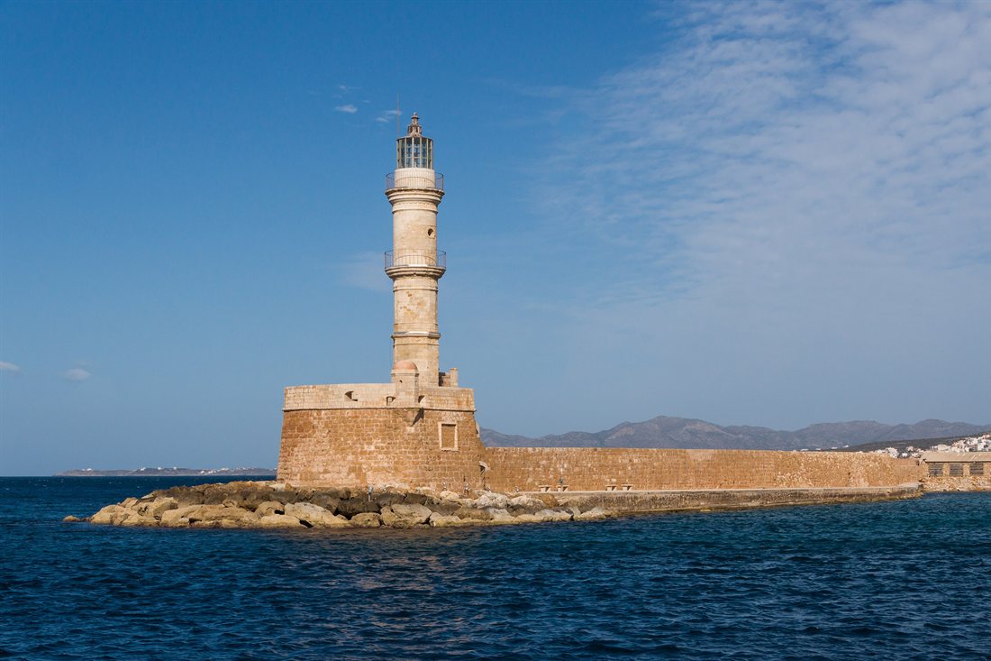
Chania is the capital of the Chania regional unit and sits on the north-west coast. A Greece travel guide to Crete continues with Chania. The old harbour borders its old town, which Venetian fortifications once surrounded. A lighthouse stands at the port.
The old town’s central part, Kasteli, has been inhabited since Neolithic times.
The ancient name of Chania was Cydonia. That name is the source of the English word quince.
Rethymno grew when Venice made it an intermediate commercial station between Heraklion and Chania. The Republic of Venice built today’s old town almost entirely, and any Greece travel guide to Crete names it. The Fortezza, a Venetian-era citadel, still stands. The Piazza Rimondi and the Loggia are among the other monuments.
Elounda is a small town on the north coast of Crete, in the municipality of Agios Nikolaos. It is formed of seven villages and an uninhabited island area. In a Greece travel guide, Elounda matters for one reason: it is the closest major town to Spinalonga.
Spinalonga is a rocky island in the Gulf of Elounda. Around 750 metres of water separate it from the village of Plaka. It served as a Venetian fortress and later as a refuge for Muslim families. In the early 20th century it became a leper colony. Nobody lives there today.
The Venetians turned the Greek phrase “stin Elounda” into “spina longa”, with spina meaning thorn and longa meaning long.
Matala is a village 75 kilometres south-west of Heraklion, north of Cape Lithinon. Artificial caves in the cliff of its bay were created in the Neolithic Age. Matala was the port of Phaistos in the Minoan period and the port of Gortys in the Roman period. Hippies occupied the caves in the 1960s.
Phaistos is a Bronze Age archaeological site in south central Crete. A Greece travel guide to the Minoan sites places it next to Knossos. It holds the remains of a Minoan palace and the surrounding town. Phaistos was one of the three largest cities of Minoan Crete, along with Knossos and Malia. Excavators found artefacts with Linear A inscriptions there.
Gortyn is a municipality and an archaeological site in the valley of Messara, south of the Psiloritis mountain. It was the Roman capital of Creta et Cyrenaica. The Gortyn Code found there is the oldest known example of a code of ancient Greek law.
What do travellers ask about a Greece travel guide?
What is the capital of Greece?
Athens is the capital of Greece and the largest Greek city, followed by Thessaloniki and Patras. The country is officially called the Hellenic Republic. It lies on the Balkan peninsula of Southeastern Europe and has thousands of islands.
What is the main language of Greece?
Greek is the official language of Greece and Cyprus and one of the 24 official languages of the European Union. It is an Indo-European language. Its written records span at least 3,400 years, the longest documented history in that family.
Which currency does Greece use?
Greece uses the euro. The country adopted it as its currency in the early 21st century, replacing the Greek drachma. Before that, it was accepted into the Economic and Monetary Union of the European Union.
Which is the largest island of Greece?
Crete is the largest island of Greece. Its capital and largest city, Heraklion, lies on the north shore. The Minoan palace at Knossos also lies in Heraklion, so every Greece travel guide to Crete passes through the city.
Which is the highest mountain in Greece?
Mount Olympus is the highest mountain in Greece. The top of the massif is the peak Mytikas, at 2,917 metres. The massif stands on the border between Thessaly and Macedonia and has 52 peaks and deep gorges.