
Zagori tours start in the mountain region north of Ioannina in Epirus, a group of stone villages known as the Zagorochoria, set around the Vikos Gorge in the Pindus range. The routes cover the gorge and its viewpoints, the arched stone bridges, the villages of Papingo and Monodendri, the Dragon Lake of Tymfi and the Voidomatis river. Greece Tours lists the hikes, jeep tours and rafting trips that start in the region.
This page covers what Zagori tours see in the gorge, the park, the villages and the monasteries, which routes cross the bridges and climb Mount Tymfi, the history of the region, what its kitchens serve, how visitors reach Zagori and which season suits each route. The tours below are checked on GetYourGuide and leave from the Zagori villages, Ioannina and Parga.
What do Zagori tours cover?
Zagori tours cover the Zagori region of Epirus in northwestern Greece, a municipality of 46 villages called the Zagorochoria in the Pindus mountains. UNESCO added the Zagori Cultural Landscape to its World Heritage list in 2023 for its stone-built villages.
Zagori covers about 1,000 square kilometres and has the shape of an upturned triangle. Ioannina, the capital of the regional unit, borders its southern point, and the city has its own set of Ioannina tours. Mount Mitsikeli, at 1,810 metres, forms the southwestern side. The Aoos river marks the northern edge, and the southeastern side follows the Varda river to Mount Mavrovouni near Metsovo.
The present municipality dates from 2011, when five former municipalities merged: Central Zagori, East Zagori, Papingo, Tymfi and Vovousa. Zagori tours cross a thinly settled district, with 3.4 people per square kilometre against 73.8 for Greece as a whole.
UNESCO inscribed the Zagori Cultural Landscape under criterion (v). The listing covers small villages along the western slopes of the northern Pindus range. Zagori tours find each village built around a central square, the mesochori, with a large church, a plane tree and a public fountain. About 93 percent of the municipality lies inside the North Pindus National Park.
- Region: Epirus, northwestern Greece, in the Pindus mountains.
- Villages: 46 settlements known as the Zagorochoria.
- Seat: Asprangeloi, in the municipal unit of Central Zagori.
- Population: 3,374 residents at the 2021 census.
- World Heritage: Zagori Cultural Landscape, added in September 2023.
What do Zagori tours see at the Vikos Gorge?
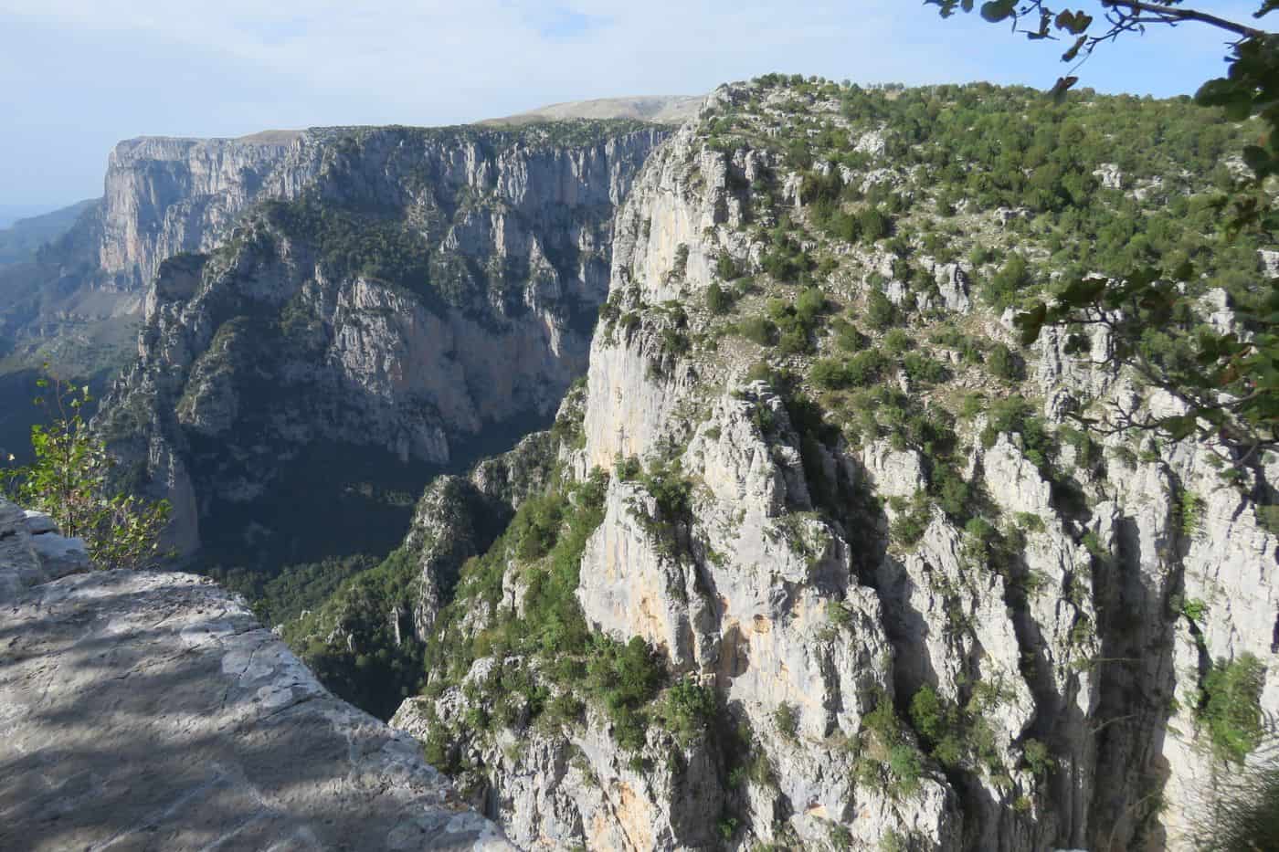
Zagori tours at the Vikos Gorge see a canyon about 32 km long with walls 120 to 1,350 m deep, viewed from Oxia and Beloi. The Guinness Book of Records lists Vikos as the deepest canyon in the world in proportion to its width.
The gorge lies in the core zone of the Vikos–Aoos National Park. Its main part begins between the villages of Vitsa and Koukouli and ends near the village of Vikos. At one point the gorge measures 900 m deep and 1,100 m wide from rim to rim, the measure behind the Guinness listing.
Zagori tours reach the Oxia viewpoint by a road of 8 km from Monodendri. The platform stands over the deepest part of the gorge. Beloi, the second viewpoint, sits on the eastern side and is reached from the village of Vradeto. Monodendri also holds the “stone forest”, a group of huge rocks that rise like trees in stacked layers of stone.
Zagori tours on foot take the trail that drops into the gorge from Monodendri and runs north along the gorge floor. Exit paths climb to Papingo on the north side or to the village of Vikos on the south side. The crossing takes about six to seven hours and is rated medium difficulty. The walk itself is covered on the Vikos Gorge hike page.
- Length: about 32 km, with 12 km inside the park core.
- Depth: walls from 120 to 1,350 m.
- Record: deepest canyon in the world in proportion to its width.
- Wildlife: chamois on the cliffs of Megas Lakos, a side ravine of the gorge.
What do Zagori tours show in the Vikos–Aoos National Park and Geopark?
Zagori tours in the Vikos–Aoos National Park show 12,600 hectares of mountain land 30 km north of Ioannina, protected as a park since 1973. The park holds the Vikos and Aoos gorges, brown bears and chamois, and carries UNESCO Geopark status.
The park is one of ten national parks in mainland Greece. It spans an elevation range from 550 to 2,497 m and belongs to the Natura 2000 network. Its core of 3,400 hectares takes in the Vikos Gorge, and forestry, grazing, hunting and fishing are banned there by law. Over 100,000 people visit the park each year.
Zagori tours reach the Aoos gorge in the north of the park, close to the town of Konitsa. The gorge runs 10 km from east to west between Trapezitsa, at 2,022 m, and Raidovouni, at 1,957 m. The dolomites on its floor date to the Early Jurassic and are the oldest rocks in the park. Sea fossils inside them fixed their age. The park was recognised as a geopark in 2010 and is one of the UNESCO Geoparks.
The park holds 1,800 plant species; 23% are Balkan endemics and 5.8% are Greek endemics. It is one of the last European strongholds of the brown bear. Wolves and roe deer live there year-round, and chamois keep to the high cliffs. Zagori tours enter a park with 121 recorded bird species, 15 of them raptors.
- Founded: 1973, as a national park.
- Area: 12,600 hectares, with a core of 3,400 hectares.
- Aoos gorge: 10 km long, near Konitsa.
- Geopark: recognised in 2010, now a UNESCO Geopark.
Which villages do Zagori tours visit?
Zagori tours visit eight villages: Monodendri, Megalo and Mikro Papingo, Aristi, Kipoi, Tsepelovo, Vitsa and Dilofo, all among the 46 Zagorochoria. Monodendri stands at 1,060 m, Tsepelovo at 1,200 m, and Papingo and Dilofo are declared traditional settlements.
The twin villages under the Astraka towers, with the Ovires rock pools and the path to the Dragon Lake, have their own Papigo tours page.
Monodendri lies 41 km north of Ioannina, in the municipal unit of Central Zagori. Its name comes from a large fir tree near the former monastery of Agios Minas. In the central square, Zagori tours see the church of Agios Athanasios. Bequests of the Rizaris brothers include the Rizarios Exhibition Center and the Rizarios Handicraft School.
Papingo is two villages, Megalo Papingo and Mikro Papingo, both inside the Vikos–Aoos National Park at the base of Mount Radovoli. The 2021 census counted 184 residents in Papingo and 39 in Mikro Papingo. Papingo stands at about 960 m and was declared a traditional settlement in 1978. Zagori tours in Papingo pass the Kallineios School of 1897 and the WWF office that helps manage the park.
- Aristi: a traditional settlement at 642 m, 48 km northwest of Ioannina, with 115 residents in 2021; its community also takes in the village of Vikos.
- Kipoi: built on a rocky hill at the southern end of the Vikos Gorge, with the museum of collector Agapios Tolis and its more than 40,000 exhibits.
- Tsepelovo: the biggest village in Zagori, at 1,200 m, and the former seat of the Tymfi municipality.
- Vitsa: at 955 m beside the Vikos Gorge, with an excavated settlement of the 9th to 4th centuries BC at Genitsari.
- Dilofo: a declared traditional settlement at 1,000 m, closed to car traffic and home to the 13.5 m Makropoulos mansion, the tallest residence in Zagori.
Which monasteries and churches do Zagori tours visit?
Zagori tours visit the monastery of Agia Paraskevi on the edge of the Vikos Gorge near Monodendri, the Spiliotissa monastery near Aristi, founded around 1579, and the monastery of St John Rogovou near Tsepelovo, founded in 1028, plus village churches painted in the Byzantine tradition.
Zagori tours reach Agia Paraskevi on a 15-minute walk from Monodendri. The monastery stands on a rough rock above the Vikos Gorge. An inscription over its gate dates the founding to the rule of Despot Carlo I Tocco. The people of Vitsa built it, with funds from the local voivode Michael Therianos. Its small stone chapel is the oldest preserved in Zagori, and a north-wall painting shows Therianos with his wife and children. It was refounded as a nunnery in 1778.
Zagori tours near Aristi reach the monastery of the Theotokos Spiliotissa, whose founding dates to around 1579. Aristi was among the first Zagori villages to have a school, and contributions from the monastery kept it running. The monastery of St John Rogovou lies 2 km outside Tsepelovo, in the Vikaki, or “small Vikos”, canyon. The sister of Emperor Romanos III Argyros founded it in 1028. It was rebuilt in 1749, and iconographers from Kapesovo painted its frescoes.
- St Elias: Monodendri monastery from the turn of the 15th century, where Georgios Gennadios and Markos Botsaris studied as children.
- Stomio: monastery built in 1774 by the Gravos waterfall in the Aoos gorge.
- Agios Nikolaos, Vitsa: church from 1612 with well-preserved frescoes.
- Agios Nikolaos, Tsepelovo: renovated in 1753, with wall paintings by Kapesovo painters.
Seven churches in the national park region are listed as protected historical monuments.
Which stone bridges do Zagori tours cross?
Zagori tours cross the three-arched Kalogeriko or Plakidas bridge of 1814 near Kipoi, the single-arched Kokkoris or Noutsos bridge of 1750, the Kontodimos bridge at the entrance to Kipoi and the Missios bridge of 1748 over the Voidomatis near Vitsa.
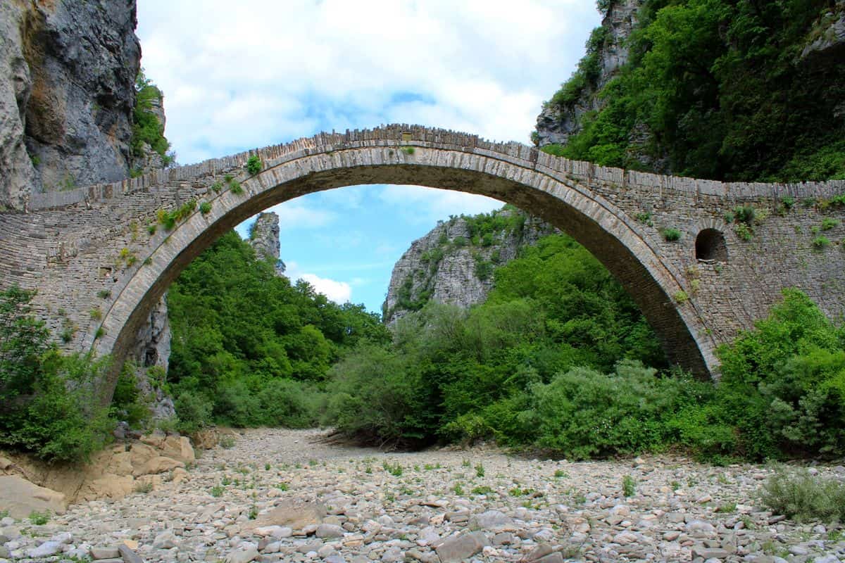
The Kalogeriko bridge stands near Kipoi and Koukouli. It replaced a wooden bridge paid for by Zotos Roussis of Negades. In 1814 Abbot Serafeim of the Prophet Elias Monastery of Vitsa spent 20,000 grosia to rebuild it in stone, which is why it carries the name Kalogeriko. Andreas and Alexandros Plakidas repaired it in 1863, and the name Plakidas bridge comes from them.
The Kokkoris bridge, also called the Noutsos bridge, stands between Koukouli, Dilofo and Kipoi. Noutsos Karamisinis of Vradeto paid for it in 1750, and his son Alexis Noutsos later repaired it. Grigoris Kokkoros of Koukouli renovated it in 1910–1911 and kept a mill beside it, which gave the bridge its other name. Zagori tours use Kipoi as the base for both: the Kalogeriko stands just outside the village, and the Kokkoris lies on the main road from Kipoi into Zagori.
- Kalogeriko: three arches, 56 metres long, with spans of 15.00, 13.50 and 11.20 metres.
- Kokkoris: one arch with a 23.6-metre span and a height of 13.3 metres.
- Kontodimos: also called the Lazaridis bridge, at the entrance to Kipoi.
- Missios: built in 1748 over the Voidomatis river near Vitsa.
Zagori tours built around the stone bridges of Zagori reach far more crossings: local master craftsmen raised over 160 arched bridges in the wider area, the bulk of them in the 18th and 19th centuries.
Which Zagori tours climb to the Dragon Lake of Tymfi?
Zagori tours to the Dragon Lake start in Mikro Papingo, climb a 6-kilometre trail to the Astraka refuge at 1,950 metres and walk 2.8 kilometres more to the lake, which lies at 2,050 metres on an alpine meadow of Mount Tymfi.
Tymfi is a limestone massif of the northern Pindus. Its highest peak, Gamila, reaches 2,497 metres, and Astraka, at 2,436 metres, towers over Papingo. The Dragon Lake, or Drakolimni, formed after the glaciers retreated. The peaks of Ploskos and Astraka overlook it, and its maximum depth is 4.95 metres.
The path from Mikro Papingo is part of the Greek national trail O3, marked with red diamonds on white. The climb to the refuge takes 2 to 3 hours, and the lake lies 1 hour beyond it. Zagori tours that go on to Gamila walk 6 more kilometres from the refuge, with no signposts, following red dots on rocks.
- Refuge: the Tymfi or Astraka hut stands below and north of the Astraka summit, and solar panels allow its use all year.
- Legend: alpine newts live in the lake, and folk tales say the lakes once held dragons that fought by throwing pines and rocks.
- Other routes: a 12.8-kilometre trail climbs from Vrysochori to Gamila through the Karteros Pass, and a 14.9-kilometre trail starts in Vradeto.
- Chamois: Tymfi holds the largest recorded population of Balkan chamois in Greece, 120 to 130 animals.
Zagori tours for climbers use 17 climbing fields on Tymfi. Giorgos Michailidis and Giorgos Xanthopoulos made the first recorded climb, up the face of Gamila, on 7–8 June 1956.
Which Zagori tours raft or walk along the Voidomatis river?
Zagori tours on the Voidomatis raft and kayak a clear, cold river that rises below the village of Vikos and runs 15 kilometres to the Aoös near Konitsa, or walk the 2-hour riverbank path that starts at the 1853 stone bridge of Kleidonia.
The name Voidomatis means the eye of the ox, because oxen have clear blue eyes like the river’s water. The river ranks among the cleanest in Europe, and its water stays very cold even in the summer months. It has been part of the Vikos–Aoös National Park since 1973. Trout live in the icy water, and century-old plane trees and alders line the banks.
The Voidomatis gorge runs from the Kleidonia bridge to the western exit of the Vikos Gorge, between Papingo and Vikos. For years it has drawn kayak and rafting groups, and the river carries a difficulty grade of 1 out of 5. Zagori tours on foot follow a marked path along the bank and pass rock shelters where people lived in the Palaeolithic. Descents of steep side ravines belong to canyoning in Zagori.
- Kleidonia bridge: one stone arch, built in 1853 for 37,000 grosia paid by the benefactress Balkiz Hanum, 2 kilometres from Kleidonia.
- Kleidi Cave: a rock shelter above the river, excavated by a British team in 1983–1986, with finds from 20,000 to 12,000 years ago.
- Agioi Anargyroi: a small chapel that Zagori tours pass on the riverside path.
- Kalyvia: a village on the west bank, on the Kozani–Ioannina national road, with hotels and restaurants that river tourism brought.
What do Zagori tours see on the Vradeto steps and at the Beloi viewpoint?
Zagori tours climb the Skala of Vradeto, a mule road of about 1,000 steps from Kapesovo, to Vradeto at 1,340 metres, the highest village of Zagori, then walk half an hour northwest to Beloi, a viewpoint on the eastern side of the Vikos Gorge.
A kalderimi is a cobbled road built for pack animals, wide enough for two loaded mules to pass, with steps of stones laid upright on steep ground. The Skala of Vradeto climbs the side of a canyon and is almost impossible to see from a distance. Master builders made it from local stone, and it was the only way in and out of Vradeto until 1973. Zagori tours on foot cover the walk from Kapesovo in about 50 minutes.
Vradeto sits on a rock with the Vikos Gorge on three sides and the slope of Tymfi behind it. Stockbreeders from Nouka, a former settlement of Skamneli, founded it in 1616. The chapel of Agios Athanasios stands at the top of the Skala. Zagori tours by car take the 9-kilometre road from the junction after Kapesovo, the only road in, a route that suits a Zagori jeep tour.
- Beloi: its name is linked to a Slavic word meaning good view or balcony.
- Balcony of Zagori: Vradeto itself carries this nickname, with open views in every direction.
- Listed monument: since 1998 the Skala and two stone bridges between Kapesovo and Vradeto have been protected as historic monuments.
- Potholes: deep shafts such as the Trypa tis Skalas lie on Vradeto land, among the deepest in Greece and Europe.
What history do Zagori tours tell?
Zagori tours tell how 14 villages won self-rule from the Ottomans in 1430, ran it through a council of elders and an elected Vekylis, lost the last privileges in 1868 and grew rich on merchant money that paid for bridges, schools and stone mansions.
Zagori tours trace the deal with Sinan Pasha, known as the Voiniko, which let each village elect elders to the council and kept Ottoman troops out. The Zagorisians maintained a small Sipahi cavalry force, each village supplying horsemen according to its means. A treaty of 1670 reformed the Koinon of the Zagorisians and added privileges called Siouroutia, among them free practice of the Christian faith and a ban on Turks entering Zagori. The league grew to 60 villages.
From the 17th century the economy rested on money from Zagorisians trading in Romania, Ukraine, Russia and Constantinople, and it peaked in the 18th century. In 1820 Alexis Noutsos of Kapesovo led the local force against 1,500 men under Ismael Pasha, and the Ottoman victory cut back the privileges. Zagori tours that reach Ioannina pass the city where the Vekylis lived from 1750, collecting taxes and judging civil cases.
- Vlachs: Aromanian speakers lived in Eastern Zagori, which joined the treaty in 1480, and a 1986 study traced 14% of 3,546 local place names to Aromanian.
- Sarakatsani: Greek-speaking nomadic shepherds who reached Zagori in the late 18th century and kept their own flocks from the mid-19th century.
- Benefactors: the brothers Manthos and Georgios Rizaris built the Common School of Greek Studies in Monodendri in 1835.
- Architecture: houses of local stone, walls up to a metre thick and stone-slab roofs held in place by weight alone.
- Liberation: Zagori joined Greece in 1913, during the Balkan Wars.
Which foods do Zagori tours taste?
Zagori tours taste the dairy kitchen of Epirus. The Municipality of Zagori lists feta, yoghurt, fresh butter, trahanas and three Zagori pies: flour pie, cheese pie and meat pie. Mountain tea, oregano, spoon sweets, jams and forest-fruit liqueurs fill the rest of the table.
Livestock farming shaped this menu. Zagori is a mountain area, so dairy products are its typical produce, even though herding has shrunk compared with the past. Shops in over half of the villages stock these products and let visitors taste them.
Epirotic cuisine rests on dairy products, butter and cheese. Its pie list names kasiopita, kothropita, kimadopita, pepeki, kasiata and blatsaria. Trahanas is a granular pasta of flour kneaded with milk or yoghurt, with grains of 2 to 3 mm, and it cooks into a soup in 15 to 20 minutes.
Ioannina, at the southern tip of Zagori, adds city dishes. The city is known for baklava, frog and eel are the specialities of Ioannina Island, and Lake Pamvotis is known for its eels and crayfish. Zagori tours that reach Vrysochori around 26 August meet the village Pie Festival.
- Feta: a PDO brine cheese of at least 70% sheep’s milk and up to 30% goat’s milk, and the Ioannina area is known for producing it.
- Galotyri: a soft, creamy PDO cheese of Epirus and Thessaly, made from very fatty sheep’s milk.
- Kefalograviera: a hard, salty PDO cheese of Epirus and Western Macedonia, cut into triangles and fried as saganaki.
- Metsovone: a semi-hard smoked pasta filata cheese from Metsovo, protected as a PDO since 1996.
How do visitors reach Zagori for Zagori tours?
Zagori tours start from Ioannina, the regional capital at the southern tip of the Zagori triangle. Ioannina National Airport (IOA) lies 5 km from the city centre, the Egnatia Odos motorway passes the city, and the village of Dilofo lies 32 km from Ioannina.
The airport carries the name King Pyrrhus and the ICAO code LGIO. Its runway measures 2,400 m, and it serves the whole Ioannina regional unit plus western and northern Greece, with flights to other parts of Greece and abroad.
Zagori tours by car use two motorways. The tolled Egnatia Odos (A2) runs 670 km from the port of Igoumenitsa to the Turkish border and passes Ioannina and Metsovo. The Ionia Odos (A5) starts at Ioannina and runs 196 km south to Antirrio, a drive of 1 hour 40 minutes. North of the city, the EO20 road heads for Konitsa west of Mount Mitsikeli, the south-western edge of Zagori.
- Vitsa: 37 km north-east of Ioannina.
- Kipoi: 39 km from Ioannina, at 750 m.
- Monodendri: 41 km north of Ioannina, at 1,060 m.
- Aristi: 48 km north-west of Ioannina, at 642 m.
- Skamneli: 54 km north of Ioannina.
Drivers on Zagori tours from Thessaloniki cross the Pindus stretch of the Egnatia Odos, between Grevena and Ioannina. Concern for endangered brown bear habitat delayed the work, a new route was drawn, and the stretch was completed by April 2009. Along its full length, the motorway runs through 76 tunnels that add up to 99 km.
When do Zagori tours run best?
Zagori tours run in every season, and the driest window is July and August, with 4.8 rain days each in Ioannina and mean highs of 31.0 °C. November and December bring over 168 mm of rain each, and winter adds frost and snow.
Climate data from the Greek National Weather Service for Ioannina, at 475 m, show 1,089.3 mm of rain a year over 123.7 days. Among mainland Greek cities above 50,000 inhabitants, Ioannina ranks as the wettest, and its records span 42.4 °C to −13 °C.
Winter Zagori tours meet extremely low temperatures in the park area. The Vikos–Aoös National Park averages 11.9 °C over the year, against 14.3 °C in Ioannina, and its summer dry spell lasts two to three months. Village stone roofs need constant upkeep because heavy snow falls on them in the winter months.
Summer fills the village calendar. Papingo holds the Prophet Elias festival on 20 July, Vitsa marks the Dormition on 15 August, and Skamneli hosts a Sarakatsani gathering at Gyftokampos on the first weekend of August.
- Winter: January in Ioannina averages 4.7 °C with a mean low of 0.2 °C, and December brings 15.2 rain days.
- Spring: rain falls from 94.9 mm in March to 76.5 mm in April, the mean temperature climbs from 8.8 °C to 12.4 °C, and Vrysochori revives its Holy Week customs.
- Summer: July averages 24.8 °C and logs 320.7 hours of sunshine, the highest monthly figure of the year.
- Autumn: September averages 20.1 °C with 62.4 mm of rain, and October rain rises to 107.5 mm.
Which day trips combine with Zagori tours?
Zagori tours combine with Ioannina and its lake island, the Perama Cave 4 km from the city, Konitsa 64 km north of Ioannina, Metsovo 52 km east on the EO6 road, and the Meteora monasteries near Kalabaka, 119 km from Ioannina.
Ioannina, the base city for Zagori tours, sits on the west bank of Lake Pamvotis, the largest lake in Epirus, with a surface of 19.4 square kilometres. Boats cross to Ioannina Island, one of two inhabited lake islands in Greece. Ali Pasha was killed there in 1822, in the monastery of St Panteleimon, now home to the Ali Pasha Museum. Ioannina Castle holds his tomb, the Fethiye Mosque and the Byzantine Museum.
The Perama Cave lies beside the lake. Residents looking for shelter from Italian bombing found it again in 1940, and it became the first cave in Greece arranged for visitors. Its visitor route runs 1,100 m, and fossil teeth and bones of the cave bear came to light there in 1956. Konitsa rises in an amphitheatre on the slopes of Mount Trapezitsa. It serves as a starting point for rafting on the Aoos and for paragliding, and Mount Smolikas, the second highest mountain in Greece, stands 15 km to the north-east.
Metsovo, at 1,160 m, is the largest centre of Aromanian life in Greece. Metsovo tours reach the Tositsa Foundation Cheese Factory, where Metsovone and Metsovela are made, and the Averoff Gallery, inaugurated in 1988. Further east, the Meteora monasteries stand on rock pillars between Kalabaka and Kastraki. Six monasteries there joined the UNESCO World Heritage List in 1988. Two brothers from Ioannina spent 22 years hoisting materials to the rock of Varlaam, 373 m above the valley floor.
- Dodona: the oldest Hellenic oracle, 22 km south of Ioannina, with a theatre built in the 3rd century BC under King Pyrrhus.
- Kavasila and Amarantos: healing baths near Konitsa, with sulphur water at Kavasila.
- Katara pass: the old EO6 route to Meteora climbs to 1,690 m, one of the highest roads in Greece.
Frequently Asked Questions
Can Zagori tours start from the Ionian coast?
Yes. Zagori tours can begin at Igoumenitsa, the chief port of Epirus, with ferries to Corfu and to Ancona, Bari and Venice in Italy. The EO6 road covers 93 km from Igoumenitsa to Ioannina, and the Egnatia Odos joins the two cities. Parga lies 40 km from Igoumenitsa, so Parga tours link the coast with the mountains.
Which drinks go with Zagori tours?
Tsipouro has its own date on Zagori tours: Vitsa holds a tsipouro festival at the end of October or in early November. Metsovo makes Katogi wine at the Averoff family vineyard. Zagori spring water sells throughout Greece, and the Vikos brand is collected in the Tymfi mountains. Salty kefalograviera matches dry white wine, ouzo or tsipouro.
Do Zagori tours run in winter?
Yes. The Municipality of Zagori presents hiking as possible in any season of the year, and Monodendri records its tourism growth above all in the winter period. Metsovo, a winter resort town east of Ioannina, has the Karakoli and Politsies ski centres for Zagori tours that add snow sports.
How long is the coach ride from Athens for Zagori tours?
KTEL coaches link Ioannina with Athens daily in 6 to 6.5 hours and with Thessaloniki in 3 hours. For Zagori tours without a car, KTEL Ioanninon runs daily routes inside the prefecture of Ioannina, which includes the Municipality of Zagori and its seat at Asprangeloi.