
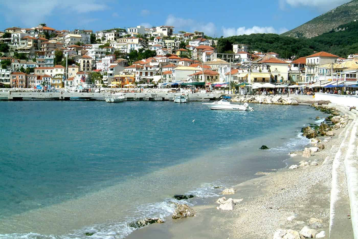
Parga tours start in a small port town on the Ionian coast of Epirus, in the Preveza regional unit, where the houses climb from a curved bay to a Venetian castle on the headland. The routes cover the castle, the beaches of Valtos and Lichnos, the islet of Panagia, the Acheron river and the boats to Paxos. Greece Tours lists the boat trips and day tours that leave from the town.
This page covers what Parga tours see in the town and along the coast, which routes run to the Acheron, the Necromanteion, Paxos, Syvota and Souli, what the town serves, how visitors reach Parga and which season suits each route. The tours below are checked on GetYourGuide and leave from Parga, Corfu and Lefkada.
What do Parga tours cover?
Parga tours cover Parga, a town on the Ionian coast of Epirus in the Preveza regional unit, home to 2,489 people at the 2021 census. Routes take in the bay, the islet of Panagia opposite the port and the Venetian castle above the town.
Parga is both a town and a municipality in the northwest of the Preveza regional unit, in northwestern Greece. On the Ionian shore, it sits between Preveza and Igoumenitsa. The municipal seat is the village of Kanallaki, not Parga itself. The present municipality dates from 2011, when the former municipalities of Fanari and Parga merged.
Parga tours begin in a town that climbs like a theatre from the Ionian shore up the Pezovolos hill, to an altitude of 139 metres. Known as the Bride of Epirus, Parga stands in the shadow of the Venetian castle, and its houses show the influence of Ionian Islands architecture.
Today Parga is the busiest resort in its area, and the municipality draws thousands of visitors each year. On Parga tours, the islet of Panagia sits across the bay, directly opposite the town.
- Town: 2,489 residents at the 2021 census, against 2,415 in 2011.
- Municipal unit: 3,819 residents across 68.9 square kilometres.
- Municipality: 10,762 residents across 274.8 square kilometres.
- Municipal districts: Agia, Anthousa, Livadari and Parga.
What do Parga tours see at the Venetian castle?
Parga tours at the Venetian castle see a fortress the Venetians began in 1792 and the French completed in 1808. It held out until 1819. Ali Pasha then added a harem and a hammam, and his emblems still mark the arched entrance gate.
The castle crowns a rocky peninsula, with water on three sides and the town on the landward side. Residents of Parga built the first walls in the 11th century, with help from the Normans, against pirates. Hatzi Bey held the site for two years from 1452. In 1537 the Ottoman admiral Hayreddin Barbarossa set fire to the fortress and the homes within its walls.
The Venetians rebuilt the castle in 1572. An inscription above the outer gate credits a section of wall to Count Marco Teotochi, governor and captain of Parga, in 1707. Parga tours inside the walls cross a citadel that once held 400 houses, with eight towers outside and water tanks fed by the Kremasma fountain.
Parga tours on foot climb to the castle through narrow lanes and steps from the port, and a paved road leads from the castle to Valtos beach. Today the castle is lit up and open to the public. Two rebuilt buildings in the central area host theatre shows and exhibitions, and the grounds hold a café and a photo exhibition space.
- Entrance gate: the winged lion of Saint Mark, the name “ANTONIO CERVASS 1764”, emblems of Ali Pasha and two-headed eagles.
- French inscription: “Défense de la Patrie A.D. 1808” over a stone door beside the powder magazine.
- Defences: vaulted corridors, barracks, prisons, warehouses and two forts on the last line of defence.
- Supply bays: Valtos and Pogonia, the two bays that brought provisions to the castle.
What history do Parga tours tell?
Parga tours tell of Venetian rule from 1401 to 1797, then French and British control. In 1819 the British handed the town to Ali Pasha of Ioannina, its people sailed to Corfu on British ships, and Parga became part of Greece in 1913.
The story Parga tours tell starts in 1318, when the town first appears in records. From 1401 Venice ran Parga as a mainland exclave of Corfu, under a castellan. After heavy Ottoman raids, the Venetian senate granted the townspeople a ten-year tax exemption in 1454. Apart from brief Ottoman spells, Parga stayed Venetian until the Republic of Venice fell in 1797.
In 1812 Ali Pasha sent his son Mukhtar, his nephew Daut Bey and 6,000 men against the town. Daut Bey was killed in the assault and buried in a mausoleum within sight of the castle. On 22 March 1814 the Pargians took the town on behalf of the British, and the French garrison withdrew.
Parga tours retell the exile of 1819. An agreement of 1817 ceded the town to Ali Pasha, and between 3,000 and 4,000 Pargians left for Corfu. On Good Friday they dug up the bones of their ancestors, burned them in the market square and took the ashes with them. Today the crossing runs the other way: in summer, boats bring visitors from Corfu, and a Parga day trip from Corfu follows that route.
- Ancient Toryne: a late Hellenistic town named after the ladle shape of its beach.
- Last mainland town: Parga was the last town on the Greek mainland to pass under Ottoman rule.
- Painting: The Refugees of Parga, an 1831 oil on canvas by Francesco Hayez, now in Brescia.
- Liberation: Pargian families returned after the liberation of 23 February 1913.
Which beaches do Parga tours reach?
Parga tours reach six beaches listed by the Municipality of Parga: Kryoneri and Piso Kryoneri inside the town, Valtos and Sarakiniko to the west, and Lichnos and Ai Giannakis to the east. Spartila, Pogonia and Plakero can be reached only from the sea.
Kryoneri, the main town beach, lies close to the centre and faces the Panagia islet. A small, tall rock that locals call Skorda rises from the water in front of it. Piso Kryoneri sits right beside it to the east, a small beach inside the town ringed by high rocks.
Valtos, west of the town and close to the castle, ranks among the longest beaches around Parga. Its Kastro Point is a surf break for experienced surfers. The Venetian customs house, the Dogana, still survives at Valtos, and the church of Agios Spyridon stands there too.
Parga tours heading east reach Lichnos, 3 km from town, with 2 hectares of sand and pebbles and two small sea caves. Ai Giannakis lies about 6 km east, past the Kalodiki wetland, with an underwater spring in its bay. To the west, Sarakiniko sits beside the village of Agia. Small boats link it with the port, so Parga tours reach it by sea as well as by road.
- Agios Sostis: a small, isolated beach about 5 km northwest of Anthousa, near a 14th-century church.
- Road access: the six beaches above and Agios Sostis can all be reached by road.
- Sea-only beaches: Spartila, Pogonia and Plakero have no road access, so a Parga yacht charter or another boat is the way in.
What do Parga tours see on the Panagia islet and at the castle of Anthousa?
Parga tours see the Panagia islet, two pine-covered hills opposite the port with a church and a small fort the French built in 1808. The castle of Anthousa, above Parga, is the fortress Ali Pasha built in 1814 to besiege the town.
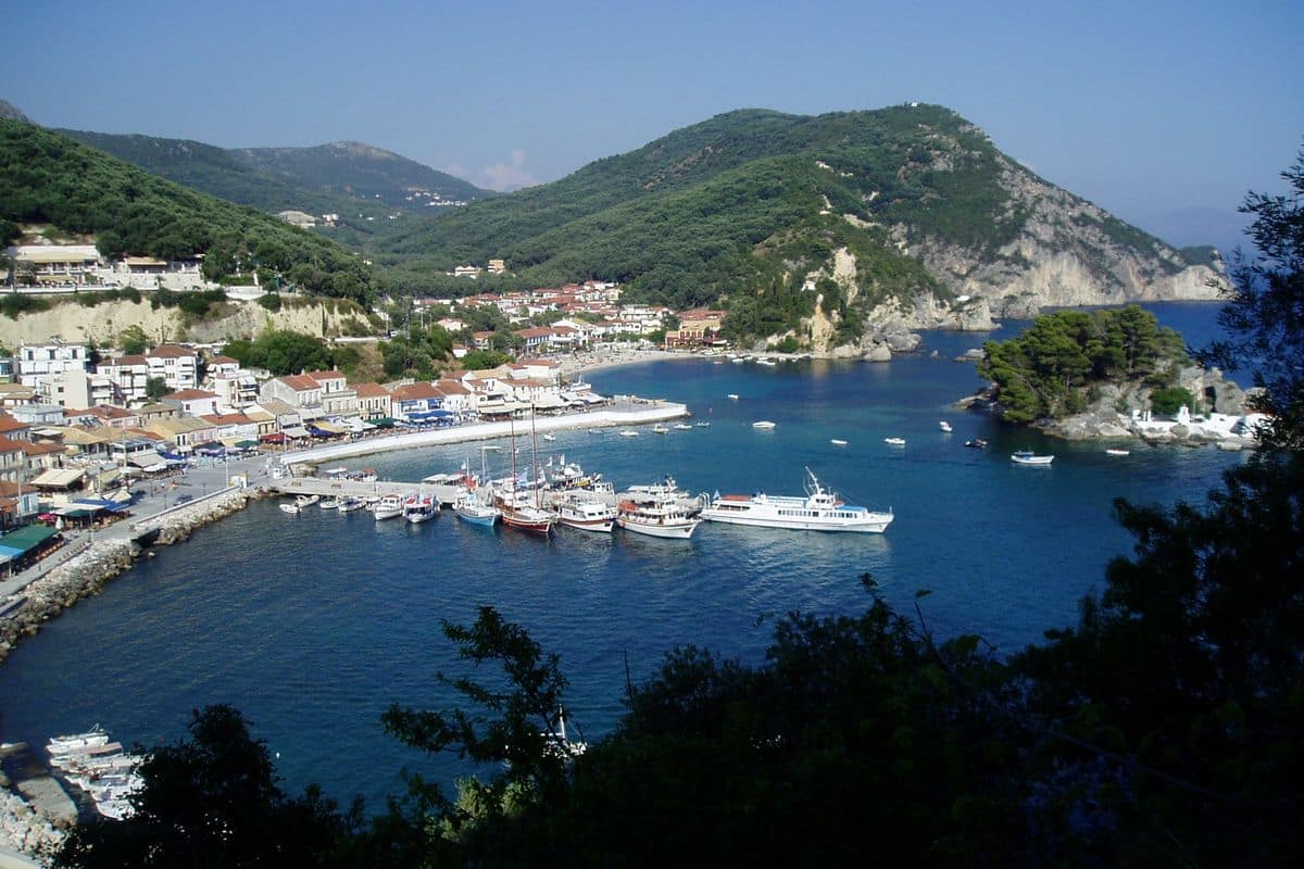
The islet is made of two low hills joined by a lower isthmus, with a highest point of 15 metres. It is wooded, mainly with pines, and takes its name from its church of the Virgin Mary, which has a bell tower. Medieval Venetian and French buildings also stand on it.
The fort, with its enclosure and gate, sits on the higher hill at the southern end. Its task was to guard a part of Parga bay that was hard to control from the large Venetian castle. On Parga tours in town, the islet is a pedal-boat ride of about five minutes from Kryoneri beach, or a swim of about 15 minutes.
Parga tours heading northwest reach the castle of Anthousa, also called Ali Pasha’s Castle, near the villages of Anthousa and Agia. The Italian engineer Don Santo di Monteleone designed it. A large bastion-tower with gun positions aimed at the town forms its main defence, and courtyards and vaulted rooms lie inside.
- Islet census: first recorded separately in 1940, with no residents at the 2011 census.
- Anthousa village: 3 km northwest of Parga, named Rapeza until 1927, with 673 residents in its community, Trikorfo included, in 2021.
- Ancient Elaia: remains and coins of this ancient city were found near Anthousa.
- Valtos–Anthousa trail: a footpath past running water, waterfalls and ruined watermills.
In 1814 Ali Pasha’s forces plundered Anthousa, and its people fled to Parga.
Which Parga tours follow the Acheron river?
Parga tours follow the Acheron, a 52-kilometre river of Epirus, at two points: upstream at its springs near Glyki, where it leaves a gorge with rock walls over 100 metres high, and downstream at Ammoudia, where its last 5 kilometres are navigable.
In Greek myth, the Acheron was the river where Charon ferried the souls of the dead into Hades. Above Glyki it cuts the Acheron Straits, a 10-kilometre gorge where the channel narrows to 2 metres between vertical rocks. A team from EOS Preveza first crossed the whole gorge in June 1994, and since 2000 a paved path has let hikers follow it.
The Springs of the Acheron lie 2 kilometres before Glyki, at the exit of the gorge. The IGME geological institute records a spring front over 500 metres long, a flow of up to 3 cubic metres per second and water at 17 degrees Celsius. Parga tours at the springs walk the easy 2 kilometres downstream, and Parga tours on the water launch canoes, kayaks and rafts from the Straits.
Downstream, boatmen based in Ammoudia run summer trips on the navigable river and to the nearby Ionian beaches. Guided canoe-kayak trips in the delta have run since 2010, and a 4-kilometre riverside path passes the Forest of Persephone. The Acheron river trip from Parga covers this route.
- Length: 52 kilometres, with a drainage area of 705 square kilometres.
- Tributaries: the Kokytos, the Pyriphlegethon and the Vovos.
- Protection: Natura 2000 site GR2140001, with 699 plant species, 449 of them in the delta.
- Wildlife: the Acheron goby, a fish found only in this river.
What do Parga tours see at the Necromanteion of Ephyra?
Parga tours see the Necromanteion on a hill at Mesopotamos, about 20 kilometres east-southeast of Parga: an oracle of the dead sacred to Hades and Persephone, with polygonal walls, iron-clad gates and a rock-cut crypt, burned by the Romans in 167 BC.
Parga tours reach the hill at the western edge of Mesopotamos, beside the Preveza–Igoumenitsa road. In Homer’s account, the Acheron met the Kokytos and the Pyriphlegethon here, on the shore of the Acherousian Lake, the entrance to the world of souls. Herodotus records that Periander, tyrant of Corinth, sent envoys here to consult the spirit of his late wife, Melissa.
Visitors came to meet the souls of dead relatives, not to ask for prophecies as at Delphi or Dodona. After a diet of broad beans, pork and oysters in dark rooms, they passed a maze-like corridor through three iron-doored gates, the Gates of Hades, into a central hall of 15 by 4.25 metres.
Sotirios Dakaris excavated the hill in 1958–1964 and 1976–1977, and all movable finds are in the Archaeological Museum of Ioannina. They include offering vessels, lamps, millstones and figurines of Persephone and Cerberus. The identification is disputed, and a later view reads the building as a fortified Hellenistic farmhouse.
- Oldest layer: Mycenaean finds of the 14th–13th century BC, with 3 child graves.
- Crypt: a rock-cut hall under 15 poros arches, with a very low reverberation time.
- Monastery: Agios Ioannis Prodromos, built on the site in the 18th century.
- Ancient Ephyra: the walls of a Thesprotian city on 2 hills, 600 metres from the sanctuary.
The hill lies 12 to 14 kilometres of river below Glyki, which puts the oracle and the springs on one route for Parga tours.
Which Parga tours sail to Paxos and Antipaxos?
Parga tours sail to Paxos, the smallest of the 7 main Ionian Islands at 25.3 square kilometres and about 15 kilometres from Parga, and on to Antipaxos, a 15-minute sea-taxi ride from Gaios, with the beaches of Vrika, Mesovrika and Voutoumi.
In summer, boats link Parga with Paxos and Antipaxos. Gaios, on the east coast, is the main town and port of Paxos. Its name comes from Saint Gaios, a disciple of Paul the Apostle who carried the Christian faith to Paxos. The islets of Agios Nikolaos and Panagia shelter its harbour.
Parga tours that stop at Gaios see the Venetian fortress on Agios Nikolaos, the islet facing the town. The baron Adam II San Ippolito won permission to build it in 1423. Since 1996, the Paxos Museum has filled a neoclassical school of 1905.
- Lakka: the second-largest port, about 8 kilometres northwest of Gaios, with the Ypapanti sea cave and a stone lighthouse of 1932.
- Loggos: a village with a small fishing harbour and an old soap factory, about 7 kilometres northwest of Gaios.
- West coast: sheer white chalk cliffs worn away at the waterline, with blue sea caves.
- Antipaxos: 5 square kilometres, 21 residents in 2021 and one harbour, Agrapidia.
- Protection: both islands belong to Natura 2000 site GR2230004.
Parga tours that continue to Antipaxos find an island where vineyards cover large parts of the land. Vrika has white sand, and the Kalogiros cave near Cape Kontari, the main cave of the island, shelters nesting seals. The Parga to Paxos boat trip page covers the crossing.
What do Parga tours see at Syvota and its islets?
Parga tours see Syvota, a seaside village of 1,089 residents in Thesprotia, and its 5 green islets, Agios Nikolaos, Mavro Oros, Megalo Mourtemeno, Mikro Mourtemeno and Chironisi, in the waters where Corinth and Corcyra fought the naval Battle of Sybota in 433 BC.
Syvota belongs to the municipality of Igoumenitsa and lies less than half an hour by road from Igoumenitsa. The village was called Volia before 1927 and Mourtos from 1927 to 1940, and its port served as an Ottoman naval base during the Greek War of Independence.
Parga tours at Bella Vraka reach the beach of Mourtemeno islet, with coarse white sand and pebbles. Visitors arrive by boat or wade across, since the water is very shallow. Pisina, a small cove with turquoise water on an islet, is reached only by boat; the same islet holds the Papanikolis cave and Diapori beach. Parga tours to Pisina therefore come in from the sea.
- Mikri Ammos: an organised cove with clear water and fine pebbles.
- Mega Ammos: the organised beach next to it, with a Blue Flag award.
- Zavia: a small bay where trees reach the water and underground springs keep the sea cold.
- Agia Paraskevi: a pebble beach named after its chapel, with a small islet in the middle.
- Vrachonas: the old settlement on the mountaintop above the village.
In the village, the church of the Ascension of the Saviour stands beside the central square, and cafés, bars and restaurants line the small harbour.
Which Parga tours go inland to Souli and Zalongo?
Parga tours go inland to Souli, the mountain home of the Souliotes in Thesprotia, with the ruined fort of Kiafa at 700 metres, and to the Zalongo Monument near Kamarina, 29 kilometres from Preveza, which honours the Souliote women who died there in December 1803.
Souli was a confederation of mountain villages near the Acheron. Its core was 4 villages: Souli, Avariko, Kiafa and Samoniva. The Souliotes defeated an army of Ali Pasha of Ioannina in 1792, but in December 1803, after a 4-year siege, they agreed to leave. Groups of refugees broke through to Parga, then under Russian control.
Parga tours to Souli see the ruins of the fortress that Ali Pasha built on Kiafa hill after the Souliotes left, once a rectangle with 2 arched gates, corner bastions and gun ports. Opposite stand the ruins of Kougi, where the monk Samuel and 5 Souliotes blew up the gunpowder stores in December 1803. A path from Skala Tzavelaina on the Acheron climbs in 3 to 4 hours to Samonida (Samoniva), the one surviving village of the old core.
The Zalongo Monument stands on a plateau of Mount Zalongo, which rises 2 kilometres east of Kamarina. Sculptor George Zongolopoulos and architect Patroklos Karantinos designed its 4 giant abstract figures of Souliote women clad in about 4,300 limestone blocks, and it opened on 10 June 1961. Accounts differ: the Prussian traveller Jakob Bartholdy recorded 22 women and 6 men who jumped, while later versions speak of about 60 women who danced to their deaths.
- Steps: Parga tours to Zalongo climb 410 steps, a walk of 20 minutes.
- Monastery: Taxiarchis Michael stands 200 metres from the monument.
- Zalongeia: the yearly commemoration in Kamarina on the second Sunday of August.
Zalongo lies in the municipality of Preveza; nearby sites appear on the Preveza tours page.
What do Parga tours taste and celebrate?
Parga tours taste olive oil from groves planted under Venetian rule and the cheeses and pies of Epirus, while local citrons once reached Europe and America. Each year on 15 August, the Pargina, or Kanareia, festival brings a boat parade lit by Venetian lanterns.
Olive farming sets the base of the local table. During their rule, the Venetians ordered the planting of the olive grove, and a significant part of the people of Parga turned to the production of olives and oil. Olive mills and soap works operated in the town, as they did in Preveza, and olive trees cover the area today.
Citrons gave Parga a second export. Parga was known for select citrons from the surrounding area, the so-called Jewish citrons, which were exported to Europe and America. The Greek citron served the Jewish ritual of the etrog during Sukkot, and in 1846 the merchant Alexander Ziskind Mintz claimed that only the citrons of Parga came from ungrafted trees and were therefore kosher.
Meals on Parga tours also follow the Epirus kitchen, which rests on dairy products, butter and cheeses such as feta, galotyri and anthotyros. Pies such as kasiopita and kothropita sit beside trahanas, hilopites and spoon sweets on the regional menu.
- Eve of the feast: boats carry people across to the islet of Panagia, in front of the town.
- 15 August: crowds gather at the harbour for the varkarola, a boat parade that re-enacts the return of the people of Parga and their holy relics.
- Boats and lights: two rows of boats set out from the castle and from Pavloukes, dressed with Venetian lanterns, and the harbour greets them with fireworks and flares.
- Patron saint: Agios Nikolaos is the patron saint of Parga, and his church is the largest in the town.
- Relics: the Church of the Twelve Apostles keeps the sacred banner, gospels, icons and vessels of Parga.
How do visitors reach Parga for Parga tours?
Parga tours begin at Aktion National Airport, 65 km away, at the port of Igoumenitsa, 40 km away, or at the airports of Ioannina and Corfu. KTEL buses run direct to Igoumenitsa and Preveza, and the A2 Egnatia Odos motorway lies 34 km from the town.
Aktion National Airport, code PVK, stands on the Aktion Peninsula in Acarnania and also goes by the name Preveza Airport. It opened in 1968 and serves Preveza and Lefkada. For Parga tours, it offers seasonal direct flights from Athens, Thessaloniki and other airports in Greece and abroad. Ioannina National Airport, code IOA, carries the name King Pyrrhus and lies 4 km from the centre of Ioannina.
Igoumenitsa is the chief port of Epirus, and its New Port is the second busiest passenger port in Greece after Piraeus. Ferries from Ancona, Bari, Venice and Brindisi in Italy call there, and frequent passenger and car ferries sail to and from Corfu. Parga tours that start in Italy therefore land 40 km from the town.
The Municipality of Parga places the area near the port of Igoumenitsa, close to the airports of Aktion and Ioannina and beside the Egnatia and Ionia Odos road axes. KTEL buses also offer indirect connections to Athens, Thessaloniki and Ioannina. In the summer months, boats link Parga every day with Paxos and Antipaxos, and boats from Corfu also arrive in summer.
- E55 national road: 10 km from Parga; it runs between Igoumenitsa and Aktio.
- A2 Egnatia Odos: 34 km from Parga; the 670 km motorway runs east to the Turkish border at Kipoi.
- Igoumenitsa: 40 km from Parga, with ferries to Italy and Corfu.
- Aktion airport: 65 km from Parga, with direct flights in season.
- Preveza: about 68 km from Parga, with direct KTEL buses.
When do Parga tours run best?
Parga tours run best from late spring through November, when the sea at Igoumenitsa, 40 km away, stays fit for swimming. Parga has a Csa climate with hot, dry summers and mild winters, a yearly average of 16.5 °C and rain mainly in winter.
Csa is the Köppen code for a hot-summer Mediterranean climate. Rain in Parga totals about 1,219 mm, or 48.0 inches, a year, and the yearly average of 16.5 °C equals 61.8 °F. Summer brings little rain.
Igoumenitsa has more detailed figures. It averages 1,100 mm of rain a year and logged 65 rainy days in 2005. Across 25 years of records, its lowest reading was −9 °C and its highest 40 °C.
- Summer: Igoumenitsa had 4 rainy days in the summer of 2005 and an average of 10 hours of sunshine a day.
- Spring and autumn: the swimming season opens in late spring and runs through the autumn months to November.
- Winter: mild on the coast, and the season of the main rains.
- Mountains: the Vikos–Aoös National Park averages 11.9 °C and 1,100.9 mm of rain a year, with a dry period of two to three months in summer.
Parga tours that head inland in summer reach Meteora in its main season for hikers, trail runners, mountain bikers and rock climbers.
Which day trips combine with Parga tours?
Parga tours combine with Ioannina, 80 km east of Igoumenitsa, the 46 villages of Zagori and the Vikos Gorge in the Pindus, the six UNESCO-listed monasteries of Meteora in Thessaly, and Corfu, which boats reach from Parga in summer.
Parga tours heading inland follow the A2 Egnatia Odos. The motorway cut the drive between Igoumenitsa and Ioannina from almost 2 hours to 40 minutes. East of Ioannina, it passes Metsovo, a Pindus town that lies between Ioannina and Meteora.
The 46 villages of Zagori, the setting for Zagori tours, spread over about 1,000 km² of the Pindus. In September 2023, UNESCO added Zagori to its list of Cultural Landscapes for its traditional stone-built settlements. More than 160 arched bridges were built in the wider area, mainly in the 18th and 19th centuries. The walls of the Vikos Gorge reach 1,350 metres deep, and the Guinness Book of Records lists it as the deepest canyon in the world in proportion to its width.
- Ioannina: the capital and largest city of Epirus sits at about 500 metres on the western shore of Lake Pamvotis, and small motorboats cross to the Island of Ioannina and its six monasteries.
- Vikos viewpoints: Oxia lies 8 km by road from Monodendri, and Beloi, on the eastern side of the gorge, is reached from Vradeto.
- Meteora: the rock pillars rise between Kalabaka and Kastraki, and the six surviving monasteries joined the UNESCO World Heritage List in 1988; Great Meteoron dates from 1356.
- Corfu: the old town joined the UNESCO World Heritage List in 2007, and two castles enclose the city, the only one in Greece surrounded this way.
Frequently Asked Questions
Do Parga tours include rafting or kayaking?
Parga tours reach rafting and canoe-kayaking rivers through day trips to the Vikos–Aoös National Park, 30 km north of Ioannina. Founded in 1973, the park spans 12,600 hectares at heights from 550 to 2,497 metres. Over 100,000 people visit it each year, and its paths also serve hiking and mountain biking.
Which craft do Parga tours find in Ioannina?
Silver leads the shopping on Parga tours that stop in Ioannina. The city is known throughout Greece for its silverwork, and its shops sell silver jewellery, bronzeware, serving trays and copies of shields and swords. A silversmithing museum in the south-eastern citadel of the castle traces the history of the craft in Epirus.
What do Parga tours eat on Corfu?
The Corfu table shows its Venetian past. Pastitsada, from the Venetian pastissada, is the top dish on the island, served beside sofrito, bianco and mandolato. Olive groves and vineyards fill the island, which has made olive oil and wine since antiquity. Its main wine grapes include the native white Kakotrýgēs and red Petrokóritho.
What weather do Parga tours meet in winter?
Parga tours in winter find a mild coast and a cold interior. Ioannina is the wettest city in mainland Greece with over 50,000 inhabitants, and its winters bring frosts and snowfall. Its record low is −13 °C, the Vikos–Aoös National Park sees extremely low winter temperatures, and heavy snowfalls hit the stone roofs of Zagori.