
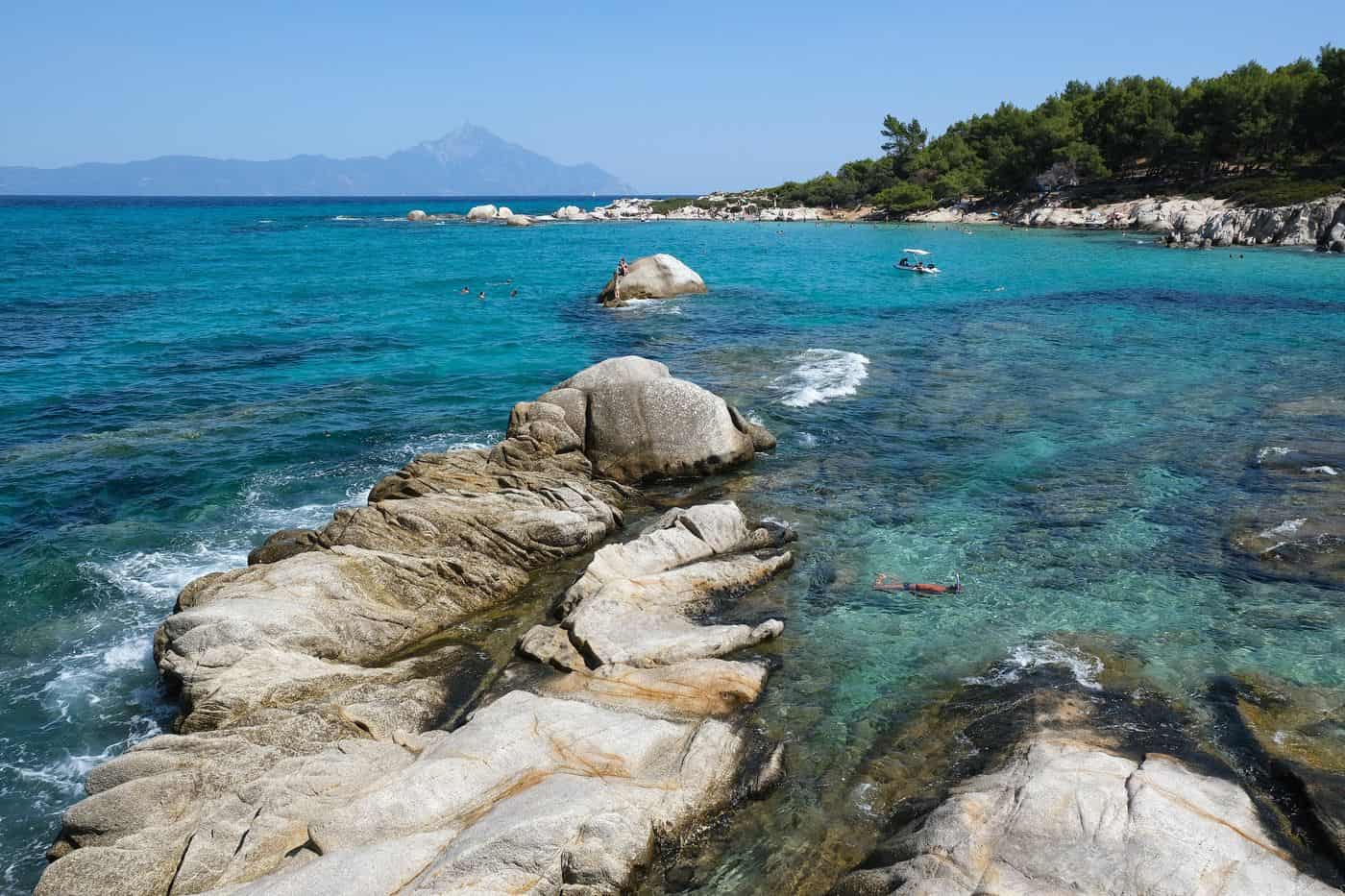
Sithonia tours start on the middle of the three peninsulas of Halkidiki, between Kassandra and Mount Athos, a peninsula of pine forests and rocky coves in northern Greece. The routes cover the villages of Nikiti, Neos Marmaras and Sarti, the beaches of Kavourotrypes and Karydi, the harbour of Porto Koufo and the boat trips along the coast. Greece Tours lists the cruises, 4×4 trips and day tours that start on the peninsula.
This page covers what Sithonia tours see in the villages, on the beaches and at the ancient sites, which boats sail the coast and around Diaporos, which roads cross Mount Itamos, what the estates serve, how visitors reach Sithonia and which season suits each route. The tours below are checked on GetYourGuide and leave from Sithonia, Neos Marmaras, Vourvourou and Thessaloniki.
What do Sithonia tours cover?
Sithonia tours cover the middle of the three Halkidiki peninsulas, between Kassandra to the west and Mount Athos to the east. The Sithonia municipality spans 514.7 square kilometres, had 12,080 residents at the 2021 census and has its seat at Nikiti.
The Toronean Gulf runs along the west coast and separates Sithonia from the Kassandra peninsula. The Singitic Gulf runs along the east coast, on the side of Mount Athos. Sithonia tours that cross the peninsula travel from one gulf to the other.
The municipality took its present shape in the 2011 local government reform. That reform merged two former municipalities, Sithonia and Toroni, which now serve as its municipal units. Nikiti has held the seat of the enlarged municipality since 1 January 2011. Sithonia tours that run the full length of Sithonia pass through both units.
The larger part of the peninsula, 233.34 square kilometres reaching down to the southern tip, is a protected Natura 2000 habitat. Forests of Aleppo pine and black pine cover the central mountain zone, and low shrubland covers the plains. The area supports the migration and breeding of protected bird species.
- Position: the second of the three Halkidiki peninsulas, counted from west to east.
- Other name: Longos, used for the peninsula alongside Sithonia.
- Name origin: Sithon, a mythical king of Thrace.
- Municipal unit Sithonia: the communities of Agios Nikolaos, Metagkitsi, Neos Marmaras and Nikiti.
- Municipal unit Toroni: the communities of Sarti and Sykia, with Toroni, Kalamitsi and Koufos inside the Sykia community.
Which villages do Sithonia tours visit?
Sithonia tours visit Nikiti, the municipal seat; Neos Marmaras, home to 3,038 permanent residents; Parthenonas, a protected traditional settlement; Sarti, with 1,054 residents at the 2021 census; Sykia, the southernmost village on the peninsula; plus Toroni, Metamorfosi and Agios Nikolaos.
Nikiti lies 100 kilometres south-east of Thessaloniki, the starting city of a Halkidiki day trip from Thessaloniki. In its old village, Sithonia tours find cobbled streets, stone houses and the Church of Saint Nikitas, built in 1867. Nikiti had just over 2,900 residents in 2021. Its beekeeping cooperative, founded in 1952, averages more than 900 tonnes of honey a year, 10% of the Greek total.
Neos Marmaras is the largest settlement and the main commercial centre of Sithonia. It faces the uninhabited island of Kelyfos, shaped like a tortoise. Parthenonas stands at 320 metres on the slopes of Itamos, with traditional Macedonian houses and the church of Agios Stefanos from 1837. For Sithonia tours, the two places belong together: the people of Parthenonas moved down to Neos Marmaras, and their village emptied in 1970. A folklore museum now runs in its restored school.
- Sarti: village on the east coast that takes its name from the ancient settlement of Sarta.
- Sykia: former seat of the Toroni municipality, with windmills and a granite school that locals call the “Parthenon of Sykia”.
- Toroni: village on the south-west edge, about 1 kilometre north of the ancient city.
- Agios Nikolaos: village 2 kilometres inland from the Singitic Gulf, with a central square of restaurants and cafes.
- Metamorfosi: village at the start of the peninsula, part of the Polygyros municipality, with 606 residents at the 2021 census.
Which beaches do Sithonia tours reach?
Sithonia tours reach Lagomandra on the west coast, Karydi and Kavourotrypes on the east coast, and Tristinika and Kalamitsi in the south. Toroni beach adds a curved strip of thick yellow sand 2.5 kilometres long on the south-west shore.
Lagomandra belongs to the Nikiti beaches, with Ai Giannis and Kalogria, that became popular when tourism boomed in the 1980s. It also appears among the swimming beaches of Neos Marmaras, next to Paradisos, Azapiko and Tristinika. Sithonia tours on this side look out over the Toronean Gulf.
Karydi belongs to the beaches of Agios Nikolaos on the Singitic Gulf. Kavourotrypes lies beside Sarti and close to Platanitsi, a Blue Flag beach 5 kilometres north of the village. Platanitsi sits inside the Natura 2000 network, and a municipal campsite of 90,000 square metres covers the larger part of the area. Mount Athos is visible from the beaches of Sarti and from the hills around the village.
In the south, Sithonia tours reach Kalamitsi, a settlement and beach of about 15,000 square metres, 6 kilometres from Sykia. In 1908, during the Macedonian Struggle, Infantry Second Lieutenant Aristovoulos Kois, the new leader for Halkidiki, landed at Kalamitsi. On the south-west side, visitors pass Tristinika and Toroni before they reach Porto Koufo.
- North, west coast: Ai Giannis, Kalogria, Elia and Lagomandra.
- North, east coast: Livrochios, Karydi, Kavourotrypes and Platanitsi.
- South: Azapiko, Tristinika, Kalamitsi and Kriaritsi.
- Toroni: 2.5 kilometres of curved beach with thick yellow sand.
What history do Sithonia tours tell?
Sithonia tours tell a history that starts with settlers from Chalkis founding Toroni in the 8th century BC, runs through the Peloponnesian War and the Byzantine monastic estates, and reaches the refugees from Asia Minor who arrived in 1922 and built Neos Marmaras and Sarti.
In antiquity, the Sithones, a Thracian tribe, lived on the peninsula. The cities between the Toronean and Singitic gulfs included Sermyle, Toroni, Galepsos and Singos. Herodotus lists Singos and Sarta among the cities near Mount Athos, and Xerxes recruited troops from them for his campaign of 480 BC.
Toroni grew into one of the leading cities of Halkidiki and paid the Athenian League 12 Attic talents a year. In the Peloponnesian War, the Spartan general Brasidas seized it in a surprise night attack and reached terms with its people in 423 BC. Philip II captured Toroni in 348 BC, and the Romans took it in 168 BC. Sithonia tours that stop at Toroni stand on the ground of these events.
In the Byzantine period, the land around Toroni held dependencies of Mount Athos monasteries. Old Nikiti and Agios Nikolaos date to the 14th century, when villagers moved inland to escape pirate raids.
- 1430: the Ottomans conquer Halkidiki and end Byzantine rule.
- 1821: the people of Sykia write to Emmanouel Pappas and join the Greek War of Independence.
- 1912: Sykia gains its liberation in November, during the Balkan Wars.
After the Asia Minor Catastrophe of 1922, refugees from the Sea of Marmara settled on the coast. People from Marmara Island built Neos Marmaras, and people from the island of Afissia settled Sarti, first named Nea Afissia. Every 15 August, Sarti holds its feast at the church of the Dormition, home of the Panagia Eleousa icon that the refugees brought from Afissia. Refugee cottages from the first years still stand in Sarti, a stop on Sithonia tours of the east coast.
What do Sithonia tours see at Toroni and Porto Koufo?
Sithonia tours see the Lekythos fortress, rebuilt in the Byzantine era on the small peninsula at the south side of Toroni beach, and the excavated ancient city. Close by, Porto Koufo forms an enclosed natural harbour that Thucydides mentions as the “hollow harbour”.
Sithonia tours at the site cover the three areas of ancient Toroni. The acropolis stood on a rocky hill between Porto Koufo and Lekythos, linked to the city by long walls. The main city filled the plateau down to the coast, and a suburb, the Proasteion, covered the neck of land between Lekythos and the city.
The XVI Ephorate of Classical Antiquities surveyed the site in 1975. Excavators studied an Iron Age cemetery of 134 tombs, 118 of them cremations. Underwater surveys show that the agora and the ancient harbour now lie under the sea, 35 metres from the coast. In 1903, the Ottomans took the granite stones of the city to pave roads in Constantinople and Thessaloniki.
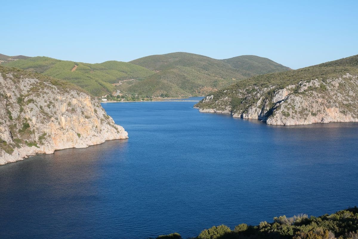
Porto Koufo opens on the Toronean Gulf near the south-west tip of Sithonia. Its entrance, about 620 metres wide, sits between rocky headlands about 90 metres high. Inside, the bay turns 90 degrees to the north, which gives safe cover in all winds. Two lighthouses mark the entrance. Sithonia tours reach a harbour that German submarines used in the Second World War; today its inner bay serves as a small fishing harbour.
- Lekythos: one of the two citadels of ancient Toroni, rebuilt with cisterns and a small early Christian temple.
- Agios Athanasios: basilica of the 5th century that burned in the 6th century; its nave mosaic survives.
- Koufos: harbour settlement with traditional fish tavernas.
- Kartalia: rocky shore outside the harbour, named after the vultures that locals call “kartalia”.
Which Sithonia tours sail the coast, and where do the boats leave from?
Sithonia tours sail from Ormos Panagias and Vourvourou on the east coast and from Neos Marmaras and the Porto Carras marina on the west coast. Tourist boats leave Ormos Panagias every day for cruises around the Athos peninsula, with stops at Ammouliani and Ouranoupolis.
Ormos Panagias serves as the port of Agios Nikolaos and as the home port of the village fishing boats. Its cruise boats cross the Singitic Gulf, which is 13 miles wide, cuts 26 miles into the land and reaches 521 metres at its deepest point. Sithonia tours on this route follow the west coast of Mount Athos and view its monasteries from the water.
On the west coast, Neos Marmaras holds the only floating port in Greece, and together with the Porto Carras marina it shelters hundreds of boats all year. Sithonia tours from the marina offer daytime cruises, sunset sailings and private yacht trips on the Toronean Gulf, the gulf that Herodotus noted for its fish.
- Mount Athos: the monastic peninsula east of Sithonia, with a summit of 2,033 metres.
- Ammouliani: an inhabited island in the Singitic Gulf and a stop on the Athos cruises.
- Ouranoupolis: the gateway town of Mount Athos, also a stop on the same route.
- Kelyfos: an uninhabited islet of 1.5 square kilometres opposite Neos Marmaras, shaped like a turtle shell, with caves in its steep rocks and wild goats and gulls as its only residents.
The Sithonia sailing tour works the same coastline under sail.
What do Sithonia tours see on Diaporos island and around Vourvourou?
Sithonia tours in Vourvourou bay reach Diaporos, the largest of nine islands, with an area of 3.2 square kilometres and a high point of 53 metres. The islets give the bay the look of a lagoon, and their beaches are reachable only by boat.
Diaporos lies in the Singitic Gulf, 10 kilometres from Agios Nikolaos, and the 2021 census recorded no permanent residents there. Pine forest covers the larger part of the island, and private holiday homes make up the bulk of its buildings. Its inlet, Kryfto, runs for more than 700 metres and shelters boats when the sea turns rough. The inlet ends in shallow water that stays warm and suits winter swimmers.
Sithonia tours bring swimmers to the shallow water around the island in summer. Myrsini Beach on Diaporos carries the name Hawaii of Sithonia for its shallow turquoise water, and ruins of the pre-Byzantine church of Agios Andreas survive on the island.
- Agios Isidoros: the easternmost island of the group; Galana Nera beach lies between it and Diaporos.
- Peristeri: a dry, rocky islet of 1.5 hectares between Ampelitsi to the east and Elia to the south-west, where pottery of the early Christian era has come to light.
- Elia: a rock islet near Diaporos in the Singitic Gulf.
- Livari peninsula: the ancient Mega Teichos, a wall of large stones, still stands by Vourvourou bay.
Sithonia tours from Vourvourou form one part of the wider Halkidiki boat tours network.
Which Sithonia tours drive the inland roads of Mount Itamos?
Sithonia tours that head inland climb Mount Itamos, the range that runs north to south through the middle of the peninsula and peaks at 817 metres. An asphalt road links Neos Marmaras with Parthenonas, the only higher village, set at 320 metres.
The range covers about 27,000 hectares, and conifer forest dominates its slopes. Sithonia tours on these slopes pass Aleppo pine and black pine in the central highlands, while phrygana scrub covers the lowlands. Beside the main summit, the named peaks include Astrapokameno at 808 metres, Psilos at 753 metres and Dragoudeli at 689 metres, west of Sarti.
Sithonia tours by road follow the route from Nikiti to Sykia across the middle of the range, and winding side roads drop from it to the main road of the peninsula. The rugged centre keeps the villages on the coast; only Sykia sits about 4 kilometres inland. Dirt tracks serve mountain bikers, wide firebreak corridors cut through the forest, and the hills support goat herding and beekeeping.
- Itamos summit: 817 metres, east of Parthenonas, with a view over the whole of Halkidiki and the Aegean.
- Protected area: the larger part of the range lies in the Oros Itamos – Sithonia Protected Area, and the Natura 2000 site covers 233.34 square kilometres from Vourvourou to the southern tip.
- Birds: the site supports the migration and breeding of protected species such as shags, booted eagles and Bonelli’s eagles.
- Parthenonas: a listed traditional settlement facing the Toronean Gulf and Kelyfos, with a folklore museum in the restored school and the church of Agios Stefanos, built in 1837.
Each year the Dragoudeli Passage event sends 8 walking routes and 1 cycling route to the village square of Parthenonas.
What wine and olive oil do Sithonia tours taste?
Sithonia tours taste the wines of Domaine Porto Carras, grown on the Meliton slopes at 200 to 300 metres, and extra virgin olive oil from Strongylolia, the dominant native olive of the Municipality of Sithonia. Halkidiki stands out for its olive oil and green olives.
The Porto Carras vines have grown on the Meliton slopes since the late 1960s, and the winery opened at the heart of the estate in 1967. The vineyard has held organic certification since 1996. Professor Émile Peynaud guided its first years, and the Domaine produced one of the first Greek PDO wines with international recognition. The estate also helped revive Malagouzia and Limnio, two of the oldest recorded Greek grape varieties.
Sithonia tours with a wine stop visit the Melissanthi Wine Tasting Room, which holds tastings all year, and add vineyard walks with views across the Aegean. The east coast keeps its own produce: Agios Nikolaos makes wine, tsipouro, honey and olive oil, and the Vourvourou area adds fish to the list.
Sithonia tours with an olive focus meet Strongylolia, also called Galano, which makes up 90% of the olives grown around Metangitsi. It gives the PDO extra virgin oil Galano Metangitsiou Chalkidikis, a blend of 90% Strongylolia and 10% Chondrolia Chalkidikis, with a green-yellow colour and a fruity olive aroma.
- Limnio: a red grape native to Lemnos, used for red wine for more than 2,000 years.
- Malagouzia: a grape grown mainly in Macedonia that gives wines with medium-plus acidity and perfumed aromas.
- Château Porto Carras: a label of the estate; its wines mature for long periods in French oak barrels.
- Old pressing: in medieval Metangitsi, workers beat sacks of ground olives with wooden boards or trod on them in wooden shoes to free the oil.
Olive oil gets a session of its own in the Halkidiki olive oil tasting.
What do Sithonia tours see at Porto Carras?
Sithonia tours at Porto Carras see the resort that shipowner Yiannis Carras began after he found the bay while sailing the Aegean in 1963: 1,763 hectares near Neos Marmaras, more than 45,000 olive trees, a winery and a private marina with 315 berths.
Yiannis Carras (1907–1989), known in English as John Constantine Carras, was a Greek shipping magnate and the grandson of captain Ioannis Carras of Kardamyla on Chios. He bought the land from the Monastery of Saint Gregory, drained the marshes and started building in 1968 with Villa Galini. The design drew on the ideas of Walter Gropius, the founder of the Bauhaus.
The Village Inn, Meliton and Sithonia hotels opened between 1974 and 1980. In June 2003 the resort hosted the European Union summit where the draft Constitution of Europe was first presented, and Belterra Investments took over the estate in 2020. Sithonia tours on the grounds follow more than 28 kilometres of trails through coastline, vineyards and woodland.
- Hotels: the 5-star Meliton and the 4-star Sithonia, with the bungalow hotels Marina Village and Kalyva Mare.
- Marina: the largest private marina in northern Greece, with a basin dredged to 5.5 metres and room for yachts up to 60 metres long.
- Vineyard: 110 hectares on the Meliton slopes, among the largest organic single estates in Greece.
- Sport: golf, tennis, basketball and football grounds, plus horse riding.
Sithonia tours by sea use the marina as a base; charter routes from Porto Carras reach Skiathos, Skopelos and Alonissos.
How do visitors reach Sithonia for Sithonia tours?
Sithonia tours rely on Thessaloniki Airport Makedonia (SKG), the nearest airport to Chalkidiki, 13 km south-east of Thessaloniki. Roads then run to Nikiti, 100 km south-east of Thessaloniki, and to Neos Marmaras, 125 km from the city, while KTEL buses serve the major towns.
The airport stands in Thermi and ranks third in size among Greek airports, after Athens and Heraklion. A second terminal opened in 2021, and both terminals hold car rental offices in their departure areas. Chalkidiki has no airport and no railway of its own, so Sithonia tours continue from SKG by road.
The A24 motorway runs from Thessaloniki south to Nea Moudania and Kallithea in Kassandra. Traffic on the Thessaloniki Inner Ring Road joins it at a large junction where the ring road ends, and the motorway then crosses the outer south-east suburbs towards Chalkidiki. The EO16 national road heads east through Thermi towards Ierissos, and its EO16a branch leaves it at Agios Prodromos for Polygyros, the capital of Chalkidiki. Nikiti lies 36 km from Polygyros, and Neos Marmaras lies 55 km from it. The road to Neos Marmaras passes Nea Moudania and Nikiti.
For Sithonia tours by bus, KTEL Chalkidikis runs the intercity services from its station at the 9th km of the Thessaloniki–Nea Moudania road, in the southern part of Thessaloniki. Sarti has buses to and from Thessaloniki five times a day.
- Airport distance: Nikiti lies 90 km from SKG.
- Motorway spur: the A242, 1.51 km long, links the A24 with the passenger entrance of the airport.
- Bus tickets: KTEL Chalkidikis sells e-tickets and open return tickets for use within the following month.
When do Sithonia tours run best?
Sithonia tours run best in summer, the season of the Ouranoupoli cruises along the Mount Athos coast and of the Toroneos Gulf Marathon swim in July. Chalkidiki has hot, relatively dry summers, and summer highs at Neos Marmaras reach around 32 °C.
Chalkidiki has a mainly Mediterranean climate, Köppen type Csa. Neos Marmaras itself sits in a hot semi-arid band, Köppen type BSh, shaped by strong Mediterranean influences. Its winter highs reach around 13 °C, and National Observatory of Athens station data place the town in hardiness zone 10a.
Summer also fills the coast. Neos Marmaras had 3,038 permanent residents in 2021, against an estimated summer population of 20,000. Nikiti grows from just over 2,900 residents to around 20,000 in summer. Sithonia tours in that season meet especially busy waterfronts at Neos Marmaras, Nikiti and Sarti.
- April: Ammouliani honours Saint George each year.
- July: Ouranoupoli holds its Ouranopolitika events.
- August: Nikiti hosts the Sithoneia, an international hammer and shot put meeting, in early August, and Ouranoupoli holds full-moon night events.
- September: Nikiti celebrates the feast day of Saint Nikitas on 15 September.
Which day trips combine with Sithonia tours?
Sithonia tours combine with five day trips: the Mount Athos coast from Ouranoupoli, Ammouliani island in the Singitic Gulf, the Kassandra peninsula to the west, the city of Thessaloniki, the second-largest city in Greece, and the Petralona Cave, 35 km south-east of Thessaloniki.
No settlement stands between Ouranoupoli and the border of the monastic state of Mount Athos. The Athos peninsula runs 50 km into the Aegean, rises to 2,033 m and holds 20 monasteries, and its monastic community joined the UNESCO World Heritage List in 1988. Summer cruises from the Ouranoupoli harbour follow this coast and keep at least 500 metres offshore. Next to the harbour stands the Tower of Prosforio, the largest and best-preserved tower in Chalkidiki, which now houses the Christian Chalkidiki Exhibition.
For Sithonia tours on the east coast, Sarti sends excursions to Mount Athos every day, and its beaches look across to the Holy Mountain. The Mount Athos cruise from Thessaloniki page covers the same coast from the city.
Of all the islands of Chalkidiki, only Ammouliani has a permanent population, and it lies between Sithonia and Mount Athos. It covers 4.5 square kilometres, counted 521 permanent residents in 2021 and sits 2 nautical miles off Trypiti, about 120 km from Thessaloniki. Sithonia tours reach it on the 10-minute ferry from Trypiti, and daily boat excursions continue to the islets of Gaidouronisi, Tigani and Pontiki. The Ammouliani cruise page covers the island by sea.
- Kassandra: the westernmost finger of Chalkidiki, with a highest point of 350 m, entered over the bridge at Nea Potidea across the Potidea canal, and home to the Sani and Siviris festivals.
- Thessaloniki: 15 Paleochristian and Byzantine monuments on the UNESCO list since 1988, the White Tower as the main landmark, and the 3 km Nea Paralia waterfront parks.
- Petralona Cave: 300 m above sea level on Mount Katsika, with about 2,000 m of corridors, more than 50 fossil animal species, more than 1,500 stone tools and the human skull found in 1960.
A local shepherd, Fillipos Chatzaridis, found the Petralona Cave in 1959 while searching for a spring. The cave now ranks second in visitor numbers among the ancient monuments of Northern Greece, with more than 50,000 visitors a year, and an onsite museum displays finds from its chambers.
Which water activities do Sithonia tours offer?
Sithonia tours offer scuba diving at Kelyfos islet off Neos Marmaras, with more than 10 dive sites and depths down to 45 metres, open-water swimming in the Toroneos Gulf, and beach water sports on both gulfs, with boat bases at Neos Marmaras and Nikiti.
Kelyfos is an uninhabited islet of 1.5 square kilometres in the Toroneos Gulf, just outside the bay of Neos Marmaras, and its turtle-like outline gives it the name Turtle Island. Divers there meet fish, a wide range of corals, anemones and starfish, and caves cut into steep rock. Dive centres hold their lessons around the islet. The Halkidiki scuba diving page covers diving across the wider peninsula.
Sithonia tours in July coincide with the Toroneos Gulf Marathon, an international swimming race held every July and first swum in 1971. Swimmers cover 25 km from Kallithea in Kassandra to Nikiti in Sithonia. Beaches on both coasts of Sithonia offer water sports, from Neos Marmaras on the Toroneos Gulf to Sarti on the Singitic Gulf, and the sandy beaches of Ammouliani offer the same in the north of that gulf.
- Neos Marmaras: the only floating harbour in Greece, which hosts boats all year.
- Nikiti: a marina on the beach front, built in 2015.
- Singitic anchorages: the harbour of Porto Sykia at the south-west horn, the harbour of Agios Dimitrios and the bay of Provlakas near the Xerxes Canal.
- Singitic Gulf: 13 miles wide, reaching 26 miles inland and 521 metres at its deepest point.
Frequently Asked Questions
Do Sithonia tours need a rental car?
No. Sithonia tours work with buses and taxis. Frequent buses link Thessaloniki with the towns of Sithonia, and Ouranoupoli has intercity buses to Thessaloniki and to the neighbouring towns of Sithonia. Taxis wait outside the airport terminal 24 hours a day, and taxis in Neos Marmaras take airport transfers.
Can women join Sithonia tours to Mount Athos?
The Athos coast cruise on Sithonia tours takes women, and its boats stay at least 500 metres from the shore. Greek law and religious tradition bar women from the monastic territory, which men enter with a diamonitirion permit after the ferry from Ouranoupoli to Dafni. Zygou Monastery, 2 km from Ouranoupoli, lies outside that territory and admits women.
What marine life lives along the routes of Sithonia tours?
Herodotus knew the Toroneos Gulf for its fish. The Mount Athos fauna list includes the Mediterranean monk seal, which numbers 250 to 300 animals in Greece, along with the yelkouan shearwater and Audouin’s gull. Sperm whales live in the deep basin between the Northern Sporades and Chalkidiki, part of a Greek population of about 300 animals.
What weather do Sithonia tours meet in winter?
Sithonia tours in winter meet the cool, wet season of Chalkidiki, with snowfalls that do not last long. Neos Marmaras stays mild, and its winters run on average slightly warmer than those of the French Riviera. The Petralona Cave holds a stable 17 °C, give or take 1 °C, all year.