
The Zagori stone bridges are single, double and triple-arched packhorse crossings built over the Voidomatis, Vikos and Bagiotiko streams between 1750 and 1935, paid for by emigrant benefactors, and about forty of them still stand among the forty-six Zagori villages. Plan the rest of the trip with Greece Tours.
This page covers the visit: which bridges to see first, where Kalogeriko and Kokkorou stand, the walk that links them, the villages they connect, why they were built and how the arches survive, the guided prices, the season, and how to book a Zagori stone bridges day.
What are the Zagori stone bridges and who built them?
The zagori stone bridges are single, double and triple-arched packhorse crossings raised over the Voidomatis, Vikos and Bagiotiko streams between 1750 and 1935, financed by emigrant benefactors, with about 40 surviving among the 46 Zagori villages inside the UNESCO cultural landscape.
Zagori occupies the northeastern flank of the Pindus range in Epirus, 25 to 55 km northeast of Ioannina. Water shaped the settlement pattern here. The Voidomatis rises from the Vikos gorge floor, the Bagiotiko drains the slopes below Kipoi and Koukouli, and each torrent swells between November and March. Stone arches were the answer, and 40-odd of them still stand on their original abutments. The Zagori stone bridges guides state this on the walk. Walkers at the Zagori stone bridges meet it in the first hour.
The oldest datable structure is the Kokkorou bridge of 1750. The newest, built at Kipoi in 1935, closes a 185-year span of masonry work carried out by crews from Konitsa and Pyrsogianni. Arch counts run from one to three. Span widths reach 24 metres on the single-arch examples, and deck heights above summer water level reach 12 metres at the higher crossings. The Zagori stone bridges season turns on this. That detail separates one of the Zagori stone bridges from the next.
The UNESCO inscription covers the Zagori cultural landscape as a whole: the drystone terraces, the kalderimi mule paths, the slate-roofed villages and the bridges that stitch them together. That listing places the crossings inside a protected system rather than treating them as isolated monuments. The North Pindus Geopark manages signage, footpath clearance and periodic repointing of parapets. The Zagori stone bridges timetable is built on it.
Visitors reach the concentration of arches around Kipoi, Koukouli and Vitsa in 50 minutes by car from Ioannina along the Egnatia Odos motorway and the provincial road through Asprangeli. Four crossings sit within 3 km of each other on that stretch of the Bagiotiko, which is why the zagori stone bridges are treated as a single half-day itinerary rather than a scattered list of sites. Every one of the Zagori stone bridges shows it.
Which Zagori stone bridges come first on a short visit?
Kalogeriko, Kokkorou and Milos near Kipoi form the core trio, all within 3 km. Add the Noutsos bridge on the Vikos stream, the Missios bridge below Vitsa, and the Klidonia bridge on the Voidomatis, 22 km west of Kipoi.
Kalogeriko, also called Plakida, is the triple-arched crossing 1.5 km below Kipoi village on the Bagiotiko. Kokkorou stands 1.2 km downstream from it, a single tall arch of 1750. The Milos bridge, named for the watermill beside it, sits 800 metres from the Kipoi car park on the old path toward Koukouli. Walking links all three on kalderimi. Every one of the Zagori stone bridges shows it. The Zagori stone bridges route is set by it.
The Noutsos bridge, known locally as Kontodimos, carries the old track between Koukouli and Dilofo across the Vikos stream. It was raised in 1753 by the benefactor Noutsos Kontodimos and rebuilt in 1795. The Missios bridge of 1748 lies below Vitsa on the same drainage, reached by a 20-minute descent on stone steps from the village edge. Walkers at the Zagori stone bridges meet it in the first hour.
Klidonia is the outlier and the largest. Its single arch of 1853 spans the Voidomatis at the mouth of the Vikos gorge, 4 km from Aristi and 22 km by road from Kipoi, roughly 35 minutes of driving. The river runs clear at 5 to 7 degrees Celsius year-round beneath it, fed entirely by karst springs. That detail separates one of the Zagori stone bridges from the next.
A first-time itinerary covering these six zagori stone bridges takes one full day with a car: three hours of walking around Kipoi in the morning, lunch in Koukouli or Dilofo, then Vitsa and Klidonia in the afternoon. Drivers who prefer no wheel time hire a guide out of Ioannina for the same circuit. A Zagori stone bridges day is planned around that.
Where is the Kalogeriko bridge and what makes its profile different?
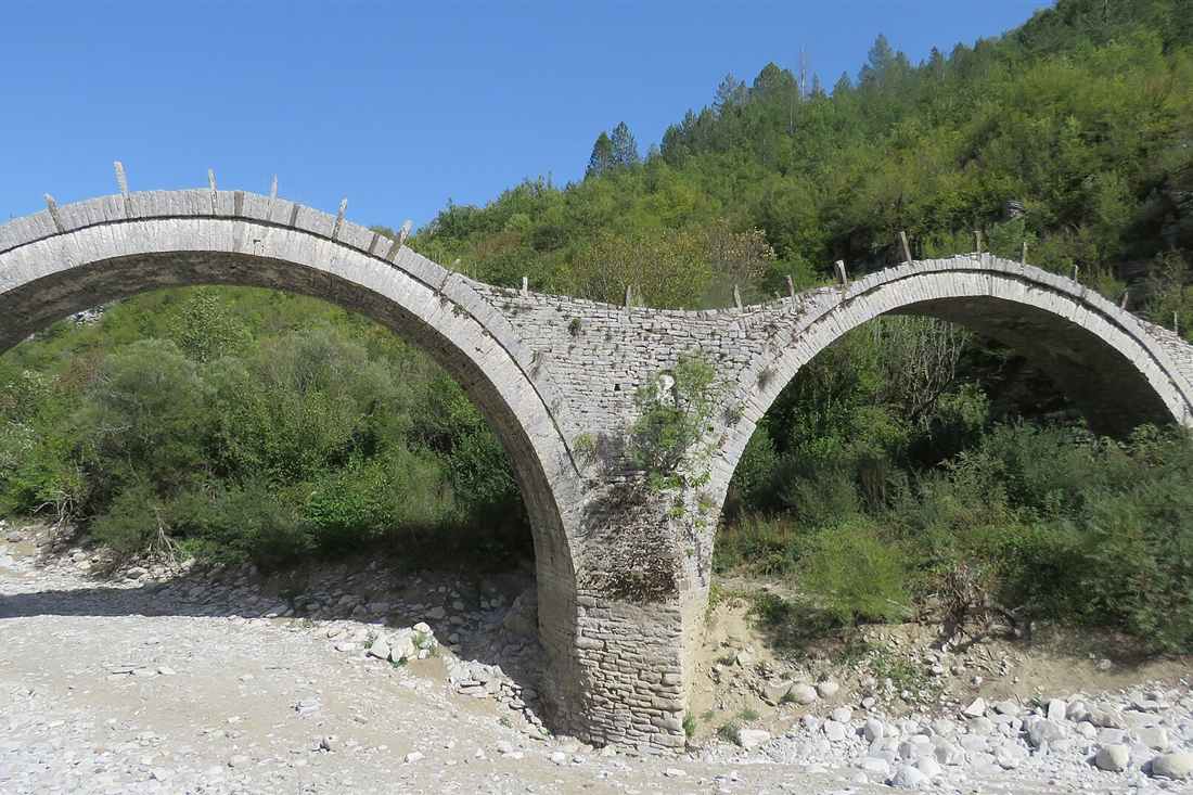
Kalogeriko, or Plakida, crosses the Bagiotiko stream 1.5 km below Kipoi on the road toward Koukouli. Three unequal arches built in 1814 and rebuilt in 1868 by the monk Seraphim give it a rippling caterpillar profile unique in Epirus.
The three arches differ in span and in springing height. The largest carries the main channel, the two smaller ones take flood overflow across the gravel bed. Because the deck rises and falls over each crown instead of running level, the silhouette reads as a series of humps. Locals call it the caterpillar. Photographers shoot it from the gravel bar downstream in late afternoon light. A Zagori stone bridges day is planned around that. A Zagori stone bridges guide carries the kit for it.
The original 1814 structure was funded by the Plakidas family of Koukouli. Damage from a winter flood forced the 1868 rebuild, financed and supervised by the monk Seraphim of the nearby monastery, which is where the alternative name Kalogeriko, meaning belonging to the monk, comes from. Both names appear on Geopark signage and on local maps. The Zagori stone bridges route is set by it.
Access is straightforward. A gravel pull-in on the Kipoi to Koukouli road holds six or seven cars, and a signed path drops to the streambed in five minutes over 40 metres of descent. The surface is loose stone and worn slab, slick after rain. The deck itself is 1.8 metres wide with low parapets and no handrail. It decides which of the Zagori stone bridges to walk to.
Kalogeriko is the single most photographed of the zagori stone bridges and the standard opening stop on guided walks. Guides use it to explain voussoir construction because the underside of the central arch is visible from the dry bank in summer, when the Bagiotiko drops to ankle depth and exposes the full ring of dressed limestone blocks. This is what the Zagori stone bridges deliver on the ground.
What is the Kokkorou bridge and why is it photographed so much?
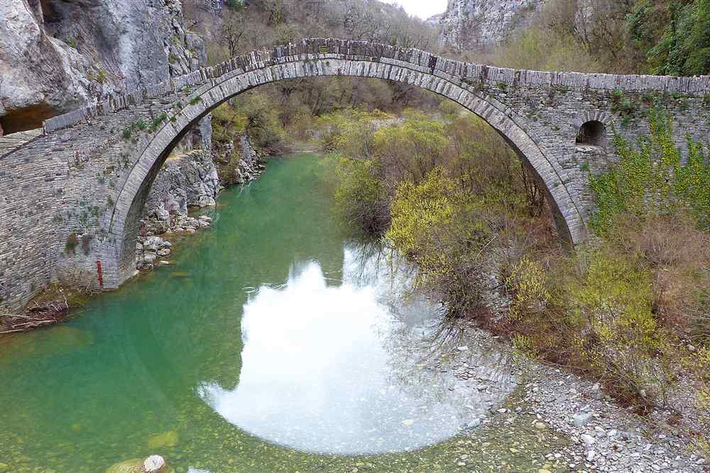
Kokkorou is a single high-arched crossing of 1750 on the Bagiotiko near Kipoi, named for its benefactor. A deep green pool sits under the span, reached by a 10-minute walk from the Kipoi road, and the view defines Zagori in print.
The arch springs from rock ledges on both banks, rising about 10 metres above summer water level with a span close to 13 metres. Because the abutments sit on bedrock rather than on gravel, the structure has taken 275 years of winter torrents without foundation movement. The deck narrows to 1.6 metres and paving slabs remain from the mule-train era. This is what the Zagori stone bridges deliver on the ground. Guides confirm it by message when a Zagori stone bridges tour is booked.
Beneath the arch the stream carves a pool three metres deep, dark green in June and shallow enough to wade by late August. Swimming is unregulated but the water holds 12 to 14 degrees Celsius even in July. The plane trees on both banks close overhead, so the crossing sits in shade for most of the day. A Zagori stone bridges guide carries the kit for it.
The trailhead is a marked pull-off on the Kipoi to Koukouli road, 1 km east of Kalogeriko. The path drops through terraced ground and reaches the bridge in 10 minutes. Sturdy shoes matter: the last 30 metres cross rounded river cobbles that shift underfoot. The Zagori stone bridges tour price reflects it.
Kokkorou appears on the covers of regional guidebooks and on the Geopark’s interpretive boards. Among the zagori stone bridges it holds the earliest confirmed date, 1750, carved into the parapet stone on the upstream side. Guides read that inscription aloud as the anchor point for the whole 185-year building programme that followed across the 46 villages. The Zagori stone bridges briefing covers it first.
How do you walk between the bridges around Kipoi?
A circular route of 2 to 3 hours links Kipoi, Kalogeriko, Kokkorou and Milos on restored kalderimi paths. Total ascent runs 150 to 250 metres, plane trees shade most of the line, and red-and-white Geopark signage marks each junction.
Start at the Kipoi village car park, elevation 780 metres. The kalderimi drops south to the Milos bridge in 15 minutes, then follows the right bank of the Bagiotiko downstream. Kalogeriko comes at the 45-minute mark. Kokkorou follows 25 minutes later. The return climbs back to Kipoi on the paved road or on the parallel mule path through the terraces. The Zagori stone bridges briefing covers it first. The Zagori stone bridges guides state this on the walk.
Kalderimi are cobbled mule roads laid with edge-set limestone and drainage channels every few metres. Crews under the North Pindus Geopark have relaid long stretches between Kipoi and Koukouli. The stones stay slick for hours after rain and freeze hard between December and February, which is when the route closes to casual walkers. Guides confirm it by message when a Zagori stone bridges tour is booked.
Water is available at the village fountain in Kipoi and at Koukouli square. Nothing along the streambed is treated. Two litres per person covers the loop in July and August, when midday air temperatures reach 33 degrees Celsius on the exposed climb back up. The Zagori stone bridges fill with walkers on that count in September.
Walkers who extend the loop toward Koukouli and the Noutsos bridge add 90 minutes and 4 km. That longer version connects five of the zagori stone bridges in a single morning and finishes at a taverna in Koukouli around 14:00. Guided groups run the short version at a slow pace with 20 minutes of commentary at each arch. A Zagori stone bridges walk starts with this settled.
Which Zagori villages do the stone bridges connect?
Kipoi, Koukouli, Dilofo, Vitsa, Monodendri, Kapesovo and Negades sit on the network the arches once served. Driving times between them run 5 to 25 minutes, and each village holds slate roofs, a stone square, a plane tree and guesthouses.
Kipoi is the administrative centre of central Zagori, 39 km from Ioannina, with a folk museum and three guesthouses. Koukouli, 3 km on, holds the Konstantinidis herbarium house. Dilofo, 5 minutes further, bans cars from its core, so arrivals park at the entrance and walk cobbled lanes to the square. Vitsa lies 4 km northwest at 960 metres. A Zagori stone bridges walk starts with this settled. Every one of the Zagori stone bridges shows it.
Monodendri, 20 minutes from Kipoi, functions as the main gateway to the Vikos gorge and the Agia Paraskevi monastery balcony. Kapesovo, at 1,100 metres, marks the foot of the Vradeto steps. Negades, east of Kipoi, holds the 1795 basilica of Agios Georgios with its painted wooden iconostasis. Roads between them are asphalt, narrow and steep in places. The Zagori stone bridges guides state this on the walk.
Roofs across all seven villages use grey Pindus schist slabs weighing 40 to 60 kg per square metre, which is why the timber trusses beneath them are so heavy. The same quarries supplied the parapet stone for the crossings. That shared material is what ties the zagori stone bridges to the settlements visually as well as historically. The Zagori stone bridges season turns on this.
Guesthouses in restored mansions run 70 to 140 euros per double room per night in Kipoi, Koukouli, Vitsa and Monodendri, with breakfast included. Aristi and Papingo, 30 minutes west, add another 20 rooms in the higher band. Booking pressure peaks over the Greek Easter weekend and across the first two weeks of August. The Zagori stone bridges timetable is built on it.
Why were the bridges built and who paid for them?
Mule trains carrying wool, cheese, timber and manufactured goods along the Zagori trade routes needed year-round crossings that winter torrents destroyed. Emigrant benefactors enriched in Constantinople, Odessa and Bucharest funded the arches, and master masons from Konitsa built them.
Zagori held a semi-autonomous tax status under Ottoman rule from 1431, which let its villages keep revenue and send men abroad to trade. Those men returned money for schools, churches, fountains and crossings. A single arch cost the equivalent of a year’s earnings from a merchant house, and donors specified their own names for the record. The Zagori stone bridges timetable is built on it. A Zagori stone bridges day is planned around that.
Between November and March the Bagiotiko and the Vikos stream rise two to three metres within hours of heavy rain on the Pindus watershed. Fords vanished. Villages lost contact for days, and mule convoys carrying salt inland and wool outward stopped moving. Each new arch removed one point of seasonal failure from the route network. Every one of the Zagori stone bridges shows it.
The builders came from Konitsa, Pyrsogianni and Vourbiani in the Mastorochoria, the villages of the master craftsmen. Crews travelled as guilds, worked between April and October, and moved on. They left no drawings. Knowledge passed from master to apprentice through direct work on centring and voussoir cutting. Walkers at the Zagori stone bridges meet it in the first hour.
Names survive carved into parapets and keystones: Noutsos Kontodimos in 1753, the Plakidas family at Kalogeriko, Kokkoros at the 1750 arch, Missios below Vitsa. Reading those inscriptions turns the zagori stone bridges from anonymous scenery into a documented ledger of who paid, in which year, and for which crossing. Guides carry transcriptions because weathering has softened the older cuts. That detail separates one of the Zagori stone bridges from the next.
How are the arches constructed and why have they survived?
Each arch uses dressed limestone voussoirs set in a ring over timber centring, bedded in lime mortar, backed with rubble fill and topped by a paved deck that sheds water. The geometry directs flood loads straight into rock abutments.
Masons cut voussoirs on site from limestone quarried within 2 km of each crossing. The wedge blocks were laid over a timber former shaped to the intended curve, working from both springings toward the crown. Once the keystone dropped in, the ring carried itself and the centring came out. Timber was reused for the next arch downstream. That detail separates one of the Zagori stone bridges from the next. This is what the Zagori stone bridges deliver on the ground.
Lime mortar matters more than it looks. It stays flexible, absorbs small movements and re-seals hairline cracks through carbonation when water passes. Portland cement, used in mid-twentieth-century patch repairs at three sites, proved too rigid and trapped moisture behind the face. Geopark restoration crews now strip cement patches and repoint with lime. A Zagori stone bridges day is planned around that.
The humped deck profile throws rainwater to the sides instead of ponding on the crown. Parapets 60 to 80 cm high protect the fill without adding significant weight. Winter floods pass under the spans at speed, and the curved intrados presents no flat surface for debris to catch, which is why timber jams rarely form. The Zagori stone bridges route is set by it.
Surviving 275 years of torrents involved losses too. Kalogeriko went down in the nineteenth century and was rebuilt in 1868. Two smaller crossings near Vovousa collapsed and were never replaced. Structural monitoring under the North Pindus Geopark now covers the main zagori stone bridges, with annual inspection of abutment scour after the spring runoff. It decides which of the Zagori stone bridges to walk to.


What does a guided Zagori stone bridges tour cost?
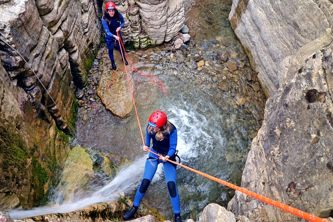
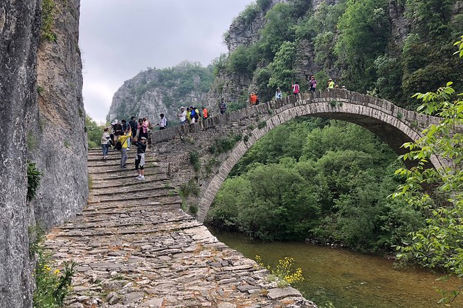
A half-day guided walk covering Kalogeriko, Kokkorou and Milos runs 30 to 60 euros per person. A full-day villages-and-bridges tour with lunch costs 70 to 120 euros. A private guide with driver from Ioannina costs 250 to 400 euros for the vehicle.
The half-day option lasts three to four hours, starts at the Kipoi car park at 09:00 or 16:00, and covers the Bagiotiko loop with a licensed guide. Group size runs 6 to 12. Price includes commentary and trail fees, excludes transport from Ioannina and food. Operators based in Monodendri and Aristi run it from April to October. It decides which of the Zagori stone bridges to walk to. The Zagori stone bridges briefing covers it first.
The full-day version adds Koukouli, Dilofo, Vitsa and Negades, with a seated lunch in a village taverna and stops at the Vradeto steps or the Agia Paraskevi monastery. Duration is seven to eight hours. The upper end of the 70 to 120 euro band includes hotel pickup within Zagori and museum entry at Kipoi. This is what the Zagori stone bridges deliver on the ground.
Private hire covers a car or minivan for up to four passengers, a licensed guide and 180 km of driving from Ioannina and back. Families and photographers take this format because the timing bends around light and pace. Companies running Ioannina tours combine the lake island of Nissi and the Perama cave with an afternoon at the arches for the same vehicle rate. A Zagori stone bridges guide carries the kit for it.
Self-driving costs far less. Car hire at Ioannina airport runs 35 to 60 euros per day, fuel for the round trip adds 15 euros, and parking is free at every trailhead. What a guide adds to the zagori stone bridges is the inscription reading, the mason-guild history and route finding on unsigned kalderimi sections. The Zagori stone bridges tour price reflects it.
When is the best season and what do you wear?
Late spring and June deliver full streams under every arch. September and October bring plane-tree colour and stable weather. Ice closes the kalderimi from December to February. Wear walking shoes with grip, a hat, and carry two litres of water.
Snowmelt from the Pindus keeps the Bagiotiko and the Vikos stream running strongly through June, which is when the pools under Kokkorou reach three metres and the arches sit above moving water. By late August the Bagiotiko drops to ankle depth in places, exposing the gravel bed and the full arch rings from below. The Zagori stone bridges tour price reflects it. A Zagori stone bridges walk starts with this settled.
Autumn walking runs from mid-September to early November. Daytime highs sit at 18 to 24 degrees Celsius, the plane and beech leaves turn between the third week of October and the first week of November, and trail traffic falls to a fraction of the August peak. Guesthouse rates drop 20 to 30 percent after 15 September. The Zagori stone bridges briefing covers it first.
Winter brings real hazard. Cobbled kalderimi glaze with ice above 900 metres from December, snow closes the Vradeto and Kapesovo roads for days at a time, and the descent to Kalogeriko becomes a genuine fall risk. Photographers who come in January stay on the road viewpoints and skip the streambeds entirely. Guides confirm it by message when a Zagori stone bridges tour is booked.
Footwear decides the day. Trail shoes or light boots with lugged soles handle worn slab and river cobble; smooth-soled trainers do not. Add a brimmed hat for the July climb back to Kipoi, a long-sleeved layer for shade at the streams, and two litres of water per person. Nothing along the zagori stone bridges route is treated drinking water. The Zagori stone bridges fill with walkers on that count in September.
How does a bridges day fit into a full Zagori trip and how do you book?
Two to three days covers Zagori properly: one day for the arches and central villages, one for the Vikos gorge, one for rafting or the Vradeto steps. Book two to five days ahead in the shoulder months, basing in Kipoi, Monodendri, Aristi or Papingo.
Day one runs the Kipoi loop in the morning and Vitsa, Dilofo and Negades in the afternoon. Day two takes the gorge. The full Monodendri to Vikos village traverse covers 12 km with 700 metres of descent and climb over six hours, and organised Vikos gorge hike departures leave Monodendri at 08:30 with a guide and transfer back. The Zagori stone bridges fill with walkers on that count in September. The Zagori stone bridges timetable is built on it.
Day three splits by season. From late spring through mid-July the Voidomatis carries enough flow for the 5 km run from the Klidonia bridge to Kleidonia village, and Voidomatis river rafting operators handle that stretch in two hours with wetsuits supplied. Walkers instead climb the 1,100 Vradeto steps from Kapesovo to Vradeto and continue to the Beloi viewpoint. A Zagori stone bridges walk starts with this settled.
Accommodation drives the logistics. Kipoi and Koukouli put walkers within 10 minutes of the arches. Monodendri suits gorge days. Aristi and Papingo, 30 to 40 minutes west, work for rafting and the Astraka refuge approach. Rooms across all of them number under 600, which is why August fills months out. The Zagori stone bridges guides state this on the walk.
Guided departures for the zagori stone bridges confirm two to five days ahead in June, September and October, and seven to ten days ahead across August and the Greek Easter period. Private guides with vehicles need longer notice. Payment is normally a 20 to 30 percent deposit with the balance settled on the day. The Zagori stone bridges season turns on this.
Frequently Asked Questions
Which are the best Zagori stone bridges to visit?
The triple-arched Kalogeriko below Kipoi, the single high arch of Kokkorou on the Bagiotiko, the Milos bridge at Kipoi, the Noutsos and Missios bridges, and the Klidonia bridge on the Voidomatis.
What does a guided Zagori stone bridges tour cost?
From 30 to 60 euros per person for the half-day guided walk, 70 to 120 euros for the full-day village-and-bridges tour with lunch, and 250 to 400 euros for a private guide and driver.
Can you walk between the Zagori stone bridges?
Yes. A two to three hour circular route on old kalderimi paths links Kipoi with the Kalogeriko, Kokkorou and Milos bridges, climbing 150 to 250 metres under plane trees, and it is signed throughout.