
Naxos holds one of the richest walking networks in the Cyclades, a lattice of marble-paved kalderimi footpaths that once tied mountain villages to threshing floors, springs and the sea. Unlike the barren cliffs of many islands, the Naxian interior is green and terraced, watered by real streams that feed olive groves, citrus orchards and the highest summit in the archipelago. Trails here range from gentle valley strolls between whitewashed hamlets to a proper 1,004-metre mountain ascent, so hikers of every level find a route that fits. Cool spring mornings, wildflowers and the scent of thyme make the island a walking destination in its own right, not merely a beach stop, which is exactly why we build slow, foot-first itineraries with My Greece Tours.
This page maps the island’s classic routes so you can match a trail to your fitness, your season and your appetite for solitude. For accommodation, ferry timings, car rental and the wider context of what to see between walks, pair it with our full Naxos travel guide. The sections below cover the Mount Zas summit path, the Melanes and Flerio kouros walk, the Halki-Filoti valley circuit, the Apeiranthos and Fanari ridges, the Cheimarros Tower route, seasonal timing and water logistics, plus honest advice on choosing between guided and self-guided days on the trail.
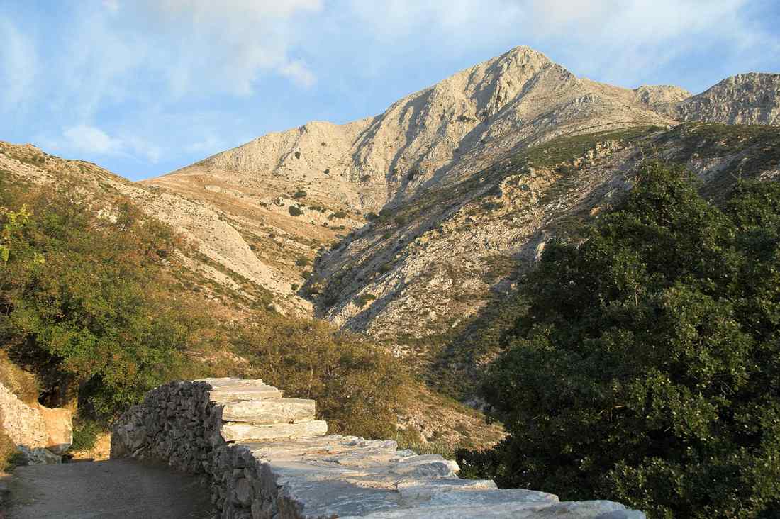
How hard is the Mount Zas summit hike?
The Mount Zas ascent is Naxos’s flagship hike: a moderate-to-strenuous 6-8 km round trip climbing to 1,004 metres in three to four hours, with 500-600 metres of gain from the Aria Spring trailhead. Fit walkers manage it comfortably.
Most hikers start at the Aria Spring car park above Filoti, where a cold natural fountain marks the lower trailhead. From there a rocky path winds up through holm oak and open mountainside, well waymarked with red dots and cairns, gaining height steadily for roughly ninety minutes before the final scramble to the trig point. The summit of Mount Zas rewards the effort with a panorama sweeping across Paros, Ios, Amorgos and, on clear days, Santorini. Mythology adds weight to the climb: the mountain is named for Zeus, said to have been raised in a cave on its slopes, and the ancient inscription reading Oros Dios Melosiou still marks the sacred boundary.
An alternative approach begins at the whitewashed chapel of Agia Marina higher on the ridge, cutting the vertical gain and shortening the walk to about two hours round trip. That shorter version suits families and those short on time. Either way, do not underestimate the exposure: the upper slopes offer no shade, the marble underfoot turns slick after rain, and afternoon heat in high summer is punishing. Carry at least two litres of water per person, wear grippy hiking shoes rather than trainers, and start early to reach the summit before the midday sun.
A brief detour into the Cave of Zas, a large dripstone cavern near the trail, adds prehistoric interest, as Neolithic finds confirm human use across millennia.
What is the Melanes and Flerio kouros walk like?
The Melanes valley walk is an easy, shaded two-to-three kilometre stroll among ancient marble quarries, ending at two colossal unfinished kouros statues. It is nearly flat, family-friendly, and takes under two hours at a relaxed pace.
This gentle route threads the lush Flerio area near Melanes, one of the greenest corners of the island, where plane trees, springs and terraced gardens create genuine shade rare on Cycladic paths. The star attractions are two recumbent kouroi, giant male figures carved from local marble in the sixth and seventh centuries BC and abandoned mid-work, probably because the stone cracked. The larger measures over six metres and lies in a private garden reached by a signposted lane. The walk suits a slow morning combined with a stop at a village taverna, and pairs naturally with exploring the surrounding villages of Naxos that ring the fertile Tragea valley below.
The broad paths and minimal gradients make the Melanes circuit ideal for children, older walkers and anyone easing into island hiking after beach days. Wear comfortable shoes rather than heavy boots, as the surface is mostly packed earth and quarry track, and bring a hat since the open sections between shaded groves still catch strong sun. Interpretive signs explain the quarrying process, from splitting blocks with wedges to the sledge routes used to haul stone toward the coast, giving the walk an open-air museum quality. Spring is glorious here, when the valley floods with poppies and the streams run full, though the route remains pleasant through autumn once the fiercest heat fades.
Which valley and village trails connect Halki and Filoti?
The Tragea valley between Halki and Filoti offers some of Naxos’s most rewarding low-level walking: shaded kalderimi paths under ancient olive groves linking Byzantine churches, ruined towers and stone hamlets across gentle, well-marked terrain suitable for half-day loops.
The heart of this network is the fertile Tragea, a vast olive plateau where marble footpaths knit together a dozen settlements. Starting from Halki, the old Venetian-era capital with its neoclassical mansions and the Vallindras distillery, walkers follow signed kalderimi through orchards to the frescoed church of Panagia Drosiani near Moni. It is one of the oldest surviving Christian monuments in the Balkans. Many of these routes are numbered and maintained under the island’s growing trail scheme, with wooden posts and coloured blazes making self-navigation straightforward. The gradients are forgiving, the surface is genuine marble paving polished by centuries of mule traffic, and the tree cover keeps most sections cool even in June.
From Halki a classic half-day loop climbs gently toward Filoti, the largest mountain village, passing Byzantine chapels, dry-stone terraces and the occasional Venetian pyrgos tower rising from the greenery. The full circuit runs roughly eight to ten kilometres and takes three to four hours with only modest climbing, ideal for hikers who want landscape and heritage without a summit push. Water is available at village fountains and tavernas along the way, so you need carry less than on the exposed mountain routes. This is the Naxos that seduces slow travellers: birdsong, church bells, the shade of thousand-year-old olives, and a footpath that has served the same villages since medieval times.
Can you hike the Apeiranthos, Fanari and Cheimarros routes?
Yes. Marble-built Apeiranthos anchors upland trails toward the Fanari ridge with sweeping Aegean views, while a longer, wilder route across the southern moorland reaches the Cheimarros Tower, a remarkably intact Hellenistic watchtower demanding a committed four to five hour round trip.
Perched high on the eastern slopes, Apeiranthos is a maze of marble streets, and its surrounding paths climb toward the Fanari area and the emery mines that once powered the local economy. Trails from Apeiranthos range from short village-edge strolls to longer ridge walks overlooking the east coast and the offshore islets. The terrain here is rockier and more open than the Tragea, so the reward is expansive views rather than shade. Many walkers combine a morning ridge hike with a visit to the village’s small archaeological and geological museums. From there they descend to the beaches at Moutsouna, where the old cable railway once delivered emery to waiting ships along the coast.
The most atmospheric long route on the island targets the Cheimarros Tower, a circular Hellenistic marble tower standing over fifteen metres tall in remote southern hills. The approach is a rough track and footpath of about six kilometres each way from the nearest parking, crossing barren, waterless moorland with no facilities. It demands full self-sufficiency: three litres of water, sun protection, sturdy boots and an early start. There is no shade and no fountain, and the surface is uneven, but the tower’s preservation and the sense of solitude make it a favourite among experienced walkers seeking the island’s wild interior away from the crowds.
When should you hike Naxos, and how do you prepare?
Hike Naxos from late March to early June and September to early November, when temperatures are mild and streams still run. Carry ample water, wear grippy footwear, start early, and take a guide on remote or high routes.
Spring is the finest season: the Tragea and Melanes valleys turn emerald, wildflowers carpet the terraces, and daytime temperatures sit comfortably in the low twenties Celsius, ideal for the Mount Zas climb. Autumn offers warm sea for post-hike swims and quieter trails once the summer crowds thin. Midsummer walking is possible only at dawn on shaded low routes; the exposed summit and southern moorland become genuinely dangerous under July and August heat. Whatever the month, water is the critical variable, as most high and southern paths have no fountains. Plan two to three litres per person and top up at village springs in the interior, where the reliable streams keep the valleys unusually green for the Cyclades.
Footwear matters more than beginners expect: the polished marble kalderimi is slick when wet or dusty, so trail shoes or light boots with good grip beat trainers or sandals. Self-guided hiking is realistic on the well-blazed Halki-Filoti and Melanes routes, where numbered posts and maps make navigation easy. A local guide adds safety and context on the Cheimarros Tower crossing or an off-season Zas ascent. Download an offline trail map, tell someone your route, and carry a phone, sun hat and snacks. Plan your visit and tours through our Naxos travel guide.
Frequently Asked Questions
Do I need a guide to hike Mount Zas?
No, most reasonably fit walkers climb Mount Zas without a guide. The main route from the Aria Spring trailhead above Filoti is waymarked with red paint dots and stone cairns. In good weather during spring or autumn, the path is easy to follow to the 1,004-metre summit. That said, a guide adds real value in specific situations. A local guide is worthwhile in certain cases. It helps in the shoulder months when cloud can settle on the peak. It is useful when you plan to combine the ascent with the Cave of Zas and the alternative Agia Marina descent. It also adds the mythological and botanical context that turns a climb into a story.
Solo hikers and families new to mountain terrain also benefit from the reassurance, since the upper section involves loose rock and mild scrambling with no phone signal in places. Whether guided or independent, always start early, carry at least two litres of water per person, wear grippy footwear, and check the forecast, because the exposed summit offers no shelter from sun, wind or sudden rain.
Are Naxos hiking trails suitable for families with children?
Many of them are, which is what makes Naxos unusually family-friendly among Cycladic islands. The Melanes and Flerio kouros walk is the standout choice: it is short, nearly flat, and well shaded by plane trees and springs. The giant unfinished marble statues genuinely captivate children, turning the outing into a treasure hunt rather than a slog. The lower Tragea valley paths between Halki and the surrounding hamlets also work well, offering gentle marble kalderimi under olive groves with frequent taverna and fountain stops to break the walk. These routes rarely exceed a few kilometres and involve little climbing.
More demanding outings such as the full Mount Zas ascent or the remote Cheimarros Tower crossing are better saved for teenagers and adults, given the exposure, loose rock and absence of water on those paths. For any family walk, bring sun hats, plenty of water, snacks and comfortable closed shoes rather than sandals, since even easy trails cross stony ground. Choosing morning starts keeps children comfortable and leaves the afternoon free for a swim at one of the island’s sandy beaches.
What should I pack for a day of hiking in Naxos?
Pack for sun, stone and scarce water, the three defining features of Naxian trails. Water is the priority: carry two litres for shaded valley walks and three for exposed routes like the Zas summit or the Cheimarros Tower, where no fountains exist. Footwear comes next, since the island’s signature marble kalderimi becomes slippery when dusty or wet, so choose trail shoes or light boots with a grippy sole over trainers or sandals. Sun protection is essential given the limited shade on high and southern paths: a wide-brimmed hat, sunglasses, high-factor sunscreen and a lightweight long-sleeved layer all help. Add trail snacks or a picnic, as remote routes pass no shops.
Bring a small first-aid kit, a fully charged phone and an offline map or GPS track downloaded beforehand, because mobile signal drops in the interior valleys and on the summit. In spring and autumn a light windproof layer guards against a chilly, breezy peak. Finally, tell someone your planned route and expected return time before setting out on any of the wilder, less-travelled paths.