
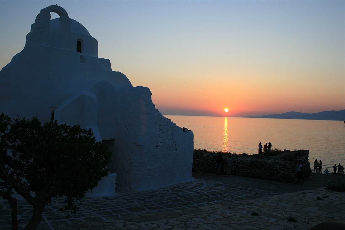
Two islands fill the western horizon of Mykonos sunset spots: Tinos at 9 nautical miles and Syros at 18, with Delos only 2 miles to the south-west. The Armenistis lighthouse stands 6.5 km from Chora, while the Megali Ammos shore is a five-minute walk from the town.
Readers who have not settled on an island can browse the Greece Tours homepage, then return for the coasts, heights and shore rules behind each Mykonos spot.
Which coasts of Mykonos face west, and which Mykonos sunset spots lie on them?
Chora, the main town, stands on the west coast, and Tourlos bay opens on the same side. Visit Greece adds Agios Ioannis and Kapari to the western side. Together they form the core of the Mykonos sunset spots on the west.
The island that holds the Mykonos sunset spots is an irregular triangle, and small coves cut into its edge. English Wikipedia says it lies 150 km east of Athens and covers 85.5 km². It is composed mainly of granite, and the ground is very rocky. Greek Wikipedia gives the coast a length of 89 km.
Greek Wikipedia counts only two mountains on the island. Both have two peaks and moderate height: Vorniotis in the north and Anomeritis in the east. The top summit of each is named Profitis Ilias. The Mykonos sunset spots of the west side lie away from both. The Mykonos island guide covers the villages and the roads.
The same article names two main bays: Panormos on the north and Tourlos on the west. It places the main harbour at Tourlos. It also lists three capes. Alegomandra lies on the south-west, Armenistis on the north-west and Evrys on the east, across from Dragonisi. Two of those capes lie on the western half of the island.
Chora wraps around a natural harbour bay, says Greek Wikipedia, and it is the largest settlement on the island. Little Venice stands on its waterfront, with wooden balconies built at the sea, says Visit Greece. English Wikipedia adds that people gather there to watch the sunset. So Little Venice is one of the Mykonos sunset spots in town.
English Wikipedia places the Kato Mili windmills in a line on a hill above the sea. Their name means lower mills in Greek. The church of Panagia Paraportiani stands beside the small north-west gate of the medieval wall, says Greek Wikipedia. Both stand inside Chora, so both are Mykonos sunset spots on the west coast.
Visit Greece counts 25 beaches on Mykonos and says they face every point of the compass. Beyond the western pair, it names these:
- South: Ornos and Platis Gialos, which Visit Greece calls the island’s hubs.
- North: Agios Stefanos, Panormos, Mersini and Fokos, plus the cove of Ftelia, which sits deep inside a bay.
- East: Elia, Kalafatis, Lia, and Pano and Kato Tigani, the last two near the eastern tip.
Which islands lie on the western horizon of the Mykonos sunset spots, and how far away are they?
Delos lies 2 miles south-west of Mykonos, and Rhenia stands just west of Delos. Tinos is 9 nautical miles away and Syros 18. These four islands fill the sea beyond the Mykonos sunset spots, with Paros south of Syros.
Delos reaches 5 km in length and 1.3 km in width. Greek Wikipedia counts 24 residents there, mainly staff of the archaeological site and museum. Rhenia lies further south-west of Mykonos, covers 13.9 km² and has 43 km of coast. Nobody lives on Rhenia today. English Wikipedia lists both islands as part of the municipality of Mykonos.
English Wikipedia lists Tinos at 37°37′N 25°08′E and Mykonos at 37°27′N 25°21′E. That puts Tinos north and west of the Mykonos sunset spots. Greek Wikipedia says the nearest coasts of the two islands lie about 5 miles apart. English Wikipedia says Exobourgo on Tinos has a jagged appearance more at home in the Alps.
Greek Wikipedia places Mykonos east of Syros, so Syros is the island to the west of the Mykonos sunset spots. The Greek Wikipedia article on Tinos puts Syros 12 miles south-west of Tinos. Syros covers 83.6 km².
From the cathedral of Ano Syros, visitors see Tinos, Delos, Mykonos, Paros, Andros and Naxos, says English Wikipedia. The capital, Ermoupoli, stands on a naturally amphitheatrical site.
Paros lies south of Syros. A ferry-route site gives 24 nautical miles, or 44 km, between Mykonos and Paros. That is the longest of the three ferry distances given here. English Wikipedia describes a single mountain that slopes evenly to a plain, with a plump pear shape. Paros lies 8 km west of Naxos, the largest island of the Cyclades.
English Wikipedia sets Mykonos among Tinos, Syros, Paros and Naxos. These are the highest points of the island and its neighbours, from low to high:
- Delos: Mount Kynthos, 115 m.
- Rhenia: 136 m.
- Mykonos: 341 m.
- Syros: Pyrgos, 442 m.
- Paros: 724 m.
- Tinos: Tsiknias, 750 m, which Greek Wikipedia places on the eastern side of Tinos.
- Naxos: Mount Zeus, 1,001 m, the highest peak in the Cyclades.
Each island stays where it is all year, so the Mykonos sunset spots keep one horizon. The hour at which the sun reaches it changes, and the sunset clock for each month lists it.
Which of the Mykonos sunset spots rise above the town on a ridge or a hill, and how high are they?
One of the Mykonos sunset spots stands on a ridge above Chora. This windmill hill carries seven of the island’s 16 windmills. The Municipality calls it a low hill. Two of the island’s highest peaks, at 372 and 386 metres, stand north of the town.
Wikipedia counts 16 windmills on Mykonos. Seven of them stand on the landmark hill in Chora. That hill is the one true ridge among the Mykonos sunset spots. The mills have their own page, which covers the windmills on the Kato Mili ridge in full.
The Municipality of Mykonos places the windmills on a low hill. Greek Wikipedia gives the town an elevation of 9 metres. Wikipedia adds that the whole village of Chora and part of the harbour are visible from the hill. A viewer there looks over the town and the harbour, where the other Mykonos sunset spots lie.
The Greek National Tourism Organisation says the last seven windmills tower over the Kastro quarter of Chora. Wikipedia describes them as round and white, with pointed roofs and very small windows. The Municipality describes the site of the Archaeological Museum of Mykonos as prominent, above the old port.
The Kastro quarter is the next place to mark on the map. Wikipedia says the Kastro neighbourhood used to be the site of a medieval castle. Wikivoyage calls it the oldest section of Mykonos Town. The ridge looks down on it, so the quarter sits lower than the mills among the Mykonos sunset spots.
The Municipality says the Paraportiani church stands on the western side of the rectangular castle of Mykonos Town. It partly crowns one of the exits of the medieval fortress towards the rocky coast. Among the Mykonos sunset spots, the complex is a two-storey block. Four churches stand on the ground floor and one is built above them.
Higher ground lies further out, away from the Mykonos sunset spots of the town. The Municipality says the island is mainly hilly. It lists Vardies at 372 metres and Profitis Ilias at 386 metres, north of the town. Greek Wikipedia names two mountains of moderate height: the Anomeritis in the east and the Vorniotis in the north.
Which of the Mykonos sunset spots sit on the waterline of the Old Port and the western shore of Chora?
The Little Venice houses stand on the western waterline of Chora, with balconies hanging over the sea. Beside them lie the Old Port, one of two ports on Mykonos, and Camel Rock off the coast. These are the waterline Mykonos sunset spots.
Wikivoyage lists Little Venice, also called Alefkandra, in the western part of Mykonos Town. Wikipedia describes rows of fishing houses along the waterfront, with their balconies hanging over the sea. The page on the Little Venice quarter covers the rest. Here only its place at the water’s edge counts.
Greek Wikipedia says the Little Venice houses are built right at the sea, in the Venetian way. The Greek National Tourism Organisation names wooden balconies and says the waves hit the houses. Wikipedia adds small basement doors with direct access to the water. Along this quarter, the walls of the houses form the shoreline of the Mykonos sunset spots.
The Municipality of Mykonos says two ports work on the island. One is the old port in Chora, the harbour spot among the Mykonos sunset spots. The other is the new port, 3.5 km north of Chora, in Tourlos bay. The Municipality names the town harbour Gialos, with a small fleet of fishing boats, boats and yachts.
The Municipality names the bay of Chora, with the bays of Panormos and Ornos, as the island’s leading bays. Greek Wikipedia places the town on the west coast, surrounded by a natural harbour bay. The Old Port, one of the waterline Mykonos sunset spots, therefore sits inside a bay, not on open coast.
Wikipedia says the windmills are the first thing seen when coming into the harbour of Alefkandra. It also lists Camel Rock, a rock formation off the coast near the Kato Mili windmills. The Greek tourism body writes that the windmills stand beside Little Venice. So the waterline and the ridge above it form one view of the Mykonos sunset spots.
Greek Wikipedia puts the Paraportiani church in the Kastro neighbourhood, next to the old port. It lies near the Little Venice area. The Greek National Tourism Organisation places it at the edge of Little Venice. Together, the Old Port, the church and the houses form one run of Mykonos sunset spots on the western shore.
What does the Armenistis lighthouse add to the Mykonos sunset spots of the north-west coast?
The Armenistis lighthouse adds a high point that looks over Delos and Tinos to the north-west Mykonos sunset spots. It is still a working navigation light. The tower stands in the Fanari area, 6.5 km from Chora.
Fanari is the Greek word for lantern, and Wikipedia calls the lighthouse a testimony to Mykonos’ maritime history. The Municipality of Mykonos places the tower in the lighthouse network of the Hellenic Navy. The road to the cape and the history of the tower sit in the guide to the Armenistis lighthouse visit.
The tower is an octagonal stone cylinder, 19 m tall, with a lantern and a gallery at the top. A one-storey stone keeper’s house is attached to it. Among the Mykonos sunset spots, it is the only one built to carry a light for ships.
Height is the main thing this tower adds to the Mykonos sunset spots of the north-west coast. The focal plane of its light is 184 m above the sea. The Municipality of Mykonos puts the reach of the light at 20 nautical miles. A nautical mile is 1,852 metres.
Wikipedia gives a rule for how far a lamp sees to the horizon. The distance in nautical miles is 1.22 times the square root of the lamp’s height in feet. A taller lamp reaches farther. A lamp must be high enough to be seen before a ship reaches the danger.
A lighthouse directory of the University of North Carolina lists one white flash every 10 seconds. That is six flashes in a minute. Wikipedia says each lighthouse has a flash pattern of its own, which sailors use to identify it. Of the Mykonos sunset spots, only the lighthouse has such a signature.
The Municipality of Mykonos says the lighthouse overlooks Delos and Tinos. Its brochure says Agios Stefanos beach faces Tinos, which lies opposite. Both of these Mykonos sunset spots look at the same island across the water.
- Lens: a Fresnel lens, which the Municipality of Mykonos calls advanced for its time.
- Design: Wikipedia says the Fresnel design cut the thickness and mass of a large lens.
- Sizes: Wikipedia says Fresnel designed six sizes of lighthouse lens, grouped into four orders.
- Builder: a French lighthouse company designed and built the tower.
- War: the light stopped for a time because of military operations and was restored after the war.
Which capes and bays of the north coast work as Mykonos sunset spots, and which face the wrong way?
The north-west headlands work as Mykonos sunset spots, because they look out to sea on the west side. The Panormos Bay beaches face the wrong way: Ftelia opens north, and Panormos and Agios Sostis open east.
The Municipality of Mykonos places the Agios Stefanos and Houlakia beaches on the west coast. That puts both among the north-west Mykonos sunset spots. It describes Houlakia as a protected beach of large pebbles on the north-west end of a small peninsula. A chapel of Agios Stefanos stands at the left end of the Agios Stefanos beach.
Tourlos is the new port, according to Wikivoyage. It adds that almost all cruise ships dock there, and that private yachts and fishing boats use its marina. It says the small Tourlos beach is used little since the port was built. Wikipedia says the island’s bus depot serves Tourlos and Agios Stefanos.
- Tourlos: about 2 km north of Mykonos Town, says Wikivoyage.
- Agios Stefanos: 3 km north of Chora, says the Municipality of Mykonos.
- Panormos and Agios Sostis: 4.5 km from Chora, says the Municipality.
- Fokos and Mersini: 12 km from Chora, past the second dam of Mykonos.
Three beaches share Panormos Bay: Ftelia, Panormos and Agios Sostis. Wikivoyage puts Ftelia in the southern part of the bay. The Municipality calls Panormos the first beach in the western part of the bay. Wikipedia lists Ftelia as an archaeological site on the beach. The bay sorts the north-coast Mykonos sunset spots by the direction each beach faces.
Wikivoyage says Ftelia faces north. The sun goes down in the west. A north-facing beach has the sunset off to one side and not in front of it. That makes Ftelia one of the Mykonos sunset spots that face the wrong way. The Municipality says rock formations divide Ftelia into two sections.
Wikivoyage says Panormos Beach faces east onto Panormos Bay, and Agios Sostis faces the east of the bay. An east-facing beach has the island at its back when the sun goes down. For these two beaches the sun sets behind land, not into the sea. They do not rank with the west-facing Mykonos sunset spots.
The Municipality places Agios Sostis in the north part of the island. It says this is the only well-known beach there with no umbrellas, sunbeds or beach services. Wikivoyage calls Fokos a small beach with coarse sand and no sunbeds or umbrellas. The Municipality says Fokos has a restaurant with private parking for swimmers.
Which west and south-west beaches count as Mykonos sunset spots, and what stands behind them?
Agios Stefanos, Agios Ioannis and Kapari are the Mykonos sunset spots among the west and south-west beaches. The Municipality of Mykonos says each one has a view of Delos. Ornos also lies on the south-west side, but its bay faces south.
Of the west-coast Mykonos sunset spots, Agios Stefanos has a view of Delos and Rhenia, says the Municipality. Its sand is sheltered. A hill stands behind the beach. The village of Agios Stefanos sits on it, north and east of the sand. A stepped footpath joins the two. Houlakia, a pebble beach, lies on the north-west of the peninsula.
Agios Ioannis lies exactly on the south-western tip of the island, says the Municipality. From there the beach looks across at Delos, the Aleomandra cape and the channel between Mykonos and Delos. Wikivoyage adds Rhenia to that view. That makes Agios Ioannis one of the Mykonos sunset spots with a named island in front of it.
Tavernas, holiday homes and villas stand around the sand. Large hotels fill the wider area around the Mykonos sunset spots of the tip. The Municipality recommends the beach for calm and rest and lists no water sports. Hotels and restaurants on the beach provide umbrellas and sunbeds. The feast of Agios Ioannis falls in the last days of September.
Kapari lies past the chapel of Agios Ioannis, north of it, says Wikivoyage. A narrow dirt road runs on to it, and a steep path leads down the last stretch. The Municipality lists fine sand and a view of Delos, with the setting sun as the special moment. It is one of the Mykonos sunset spots that needs a walk.
Greek Wikipedia puts Ornos in the south-west too, but its bay is not among the Mykonos sunset spots here. The Municipality says the beach sits at the back of a large, safe bay with a south orientation. It lists hotels, restaurants, cafes, bars and a diving school around the sand.
The Municipality puts Korfos just before the Ornos settlement, with a boat ramp at the west end of its beach. Ornos is the first of the southern beaches and has a small fishing harbour. Greek Wikipedia adds that Ornos was once the fishing harbour of the island. Today the village holds hotels, guesthouses, restaurants and shops.
Which south and east beaches lose the sun early, and where does it set behind them?
Elia, Kalo Livadi and Kalafatis lose the sun behind the island itself, because Chora stands on the west coast. The south-coast beaches lose it behind a headland and a hill. None of them stands on the west coast, where the Mykonos sunset spots cluster.
The Municipality files Psarou, Platis Gialos, Paraga, Paradise, Super Paradise and Agrari under the south coast. OpenStreetMap places them from west to east in that order, with Elia, Kalo Livadi and Kalafatis after them. That order matters for the Mykonos sunset spots. Every beach in the list has the earlier ones on its west side.
Greek Wikipedia places Platis Gialos on the south coast, toward the western part of the island. Psarou, Ornos and Agios Ioannis lie west of it. The Municipality calls Platis Gialos a relatively large sandy beach, well organised and ringed by hotels. It calls Psarou organised too, with water sports, sunbeds and showers. The full beach list covers both beaches.
Paraga lies between Platis Gialos and Paradise and looks out on Cape Drapanos, says the Municipality. Wikivoyage describes a headland at Paraga. Paradise follows, a large beach of coarse sand. Wikivoyage gives a 20-minute walk over a hill from Paradise to Super Paradise. Among the south-coast Mykonos sunset spots, Super Paradise has a hill on its west side.
The Municipality says Agrari has two distinct sections. Wikivoyage gives a 5-minute walk over the rocks from Elia to Agrari, and OpenStreetMap puts Agrari west of Elia. Among the south-east Mykonos sunset spots, Elia therefore has rocks on its west side. The Municipality lists fine sand at Elia and groups it with the south-east beaches.
The Municipality puts Kalo Livadi between Elia and Kalafatis. It is one of the largest beaches on the island by length and width. Venues near it give organised services in their grounds and on the beach. Kalafatis has tamarisk trees. A small beach, Agia Anna, lies beside it with sunbeds, umbrellas and a beach volleyball court.
English Wikipedia says Mykonos town stands on the west coast. Elia, Kalo Livadi and Kalafatis sit in the south-east. The island lies between each of them and the west shore. The sun sets in the west, and from these three beaches it sets behind the land of Mykonos. They are not Mykonos sunset spots in the west-coast sense.
What can visitors see of the sunset from Rhenia and Delos, and who is allowed to stay there after dark?
The Mykonos sunset spots have two protected neighbour islands, Delos and Rhenia. Visitors on Delos look west across the Strait of Delos toward Rhenia. Overnight stays of individuals without special permission are prohibited on both islands. Only staff and permit holders remain after dark.
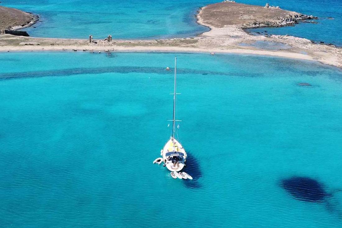
Delos has its own west side, apart from the Mykonos sunset spots. The French School at Athens places two Rhevmatiari islets opposite its western coastline. A small harbour on that side serves the tourist boats. The only valley lies west of the hill of Kynthos. The sanctuary, the ancient city and the sacred lake developed there.
Rhenia lies just west of Delos, across the Strait of Delos. A viewer on the western side of Delos therefore looks toward Rhenia. Delos stands close to the Mykonos sunset spots, yet it is a World Heritage Site with its own rules. The Delos visitor guide covers the crossing and the monuments.
The Cyclades Ephorate of the Ministry of Culture lists the Delos site as open every day from September to November. The hours shorten as autumn goes on. Last admission falls 20 minutes before closing time. These hours decide whether Delos fits a day built around the Mykonos sunset spots.
- 1 to 15 September: 08:00 to 19:30
- 16 to 30 September: 08:00 to 19:00
- 1 to 15 October: 08:00 to 18:30
- 16 to 31 October: 08:00 to 18:00
- 1 to 30 November: 08:00 to 16:00
The Delos site stays shut between 1 December and 31 March, and a winter visit needs a written request. The site also closes on 1 January, 25 March, Easter Sunday, 25 December and 26 December. The heritage portal run with the Ministry gives 08:00 to 20:00 for 1 April to 31 August.
The Municipality of Mykonos says that Delos and Rhenia are under the protection of the Ministry of Culture. It adds that the mooring of vessels and the overnight stays of individuals without special permission are prohibited. Greek Wikipedia describes the residents of Delos as guards and staff. These rules set both islands apart from the Mykonos sunset spots.
Rhenia took the dead of Delos. The Municipality of Mykonos writes that the bones of all the dead of Delos were moved to Rhenia. English Wikipedia says pregnant women and people close to death were carried over to it. Greek Wikipedia adds a healing facility for the seriously ill. Flocks from Mykonos graze on Rhenia today.
Which Greek rules keep the shore open to everyone at the Mykonos sunset spots?
Greek law treats the seashore and the beach as public property. A walker can stand at the waterline of any beach among the Mykonos sunset spots. Permanent buildings are not allowed on the foreshore, and the coastal law names free access for citizens as its aim.
The Greek word for the seashore is aigialos. Greek law defines it as the strip of land that the sea wets. It reaches the level of the usual largest winter waves. The beach, called paralia, is a parallel zone added to it that can reach up to 50 m. Each beach among the Mykonos sunset spots has both strips.
On the sand of the Mykonos sunset spots, the shoreline, the beach and the bank belong to the State. It protects and manages them. Greek law calls them common-use things. The foreshore is public, and permanent constructions are not allowed on it. The State does not create the aigialos by an act, since it follows from natural processes.
The Greek coastal development law lists stricter rules for managing beaches and free access for citizens among its aims. It sets stricter penalties for violations. It provides for the removal and demolition of illegal structures. Beaches under the Natura designation cannot be developed. The law covers every Greek beach, so the Mykonos sunset spots on the sand fall under it.
Press reports on the beach bill list a lessee’s duties. A lessee is a business that leases part of a beach.
- help people with disabilities reach the beach
- post the lease details on the beach
- keep the natural form of the coast and shoreline
- keep umbrellas, sunbeds and other equipment within a capped percentage of the leased area
- use movable facilities
- provide lifeguards where municipal cover falls short
A consumers’ union states the rule for a property between a public road and the coast. The holder or concessionaire must provide a free passage for the unhindered and safe access of citizens. It adds that beach bar operators must ensure free, safe and unobstructed access of the public to the beach.
At the Mykonos sunset spots on a beach, a viewer who walks to the waterline stands on the public foreshore. The free-passage rule covers the route to it. The bill also provides for a free mobile app where citizens report violations. For the view from the water itself, read about sunset sailings from the Old Port.
How do the north wind and the sea state change the Mykonos sunset spots on the exposed coasts?
The Etesian wind blows from the north between late spring and mid-September. At its strongest it reaches force 7 to 8 of the Beaufort scale. The Municipality of Mykonos calls the northern beaches exposed to it. Mykonos sunset spots on that coast need a calm day.
The Hellenic National Meteorological Service names the north wind of the Aegean the Etesian. On the Cyclades the same wind is called the meltemi. A deep continental depression over south-west Asia drives it. Its direction runs anywhere from north-east to north-west, set by the local land.
The wind is strongest in the afternoon and can die down at night. It comes up in clear weather without warning. A spell can last for days without a break. For the Mykonos sunset spots, a clear sky is no sign of a calm one.
A hydrographer of the British Royal Navy devised the Beaufort scale in the 19th century. Forces 5 to 8 run from a fresh breeze to a gale. Read them as a guide to the wind at the Mykonos sunset spots:
- Force 5, fresh breeze, 29 to 38 km/h: small trees in leaf sway. At sea, white horses form and there is a chance of spray.
- Force 6, strong breeze, 39 to 49 km/h: large branches move and umbrellas are used with difficulty. Large waves begin to form.
- Force 7, near gale, 50 to 61 km/h: whole trees move and walking against the wind is an inconvenience. The sea heaps up and foam blows in streaks.
- Force 8, gale, 62 to 74 km/h: twigs break off trees and progress is impeded. The crests of the waves break into spindrift.
The Municipality of Mykonos calls the northern beaches exposed to the strong island wind. It advises a visit on a day of light north wind. Megali Ammos is very exposed to north winds, and Korfos has strong wind of steady direction. Pick a light-wind day for the Mykonos sunset spots on these shores.
Wikivoyage places the south-side beaches in shelter from the prevailing north wind. The municipality calls Ornos a sheltered beach in a large, safe, south-facing bay. Behind a windbreak of trees or shrubs, the wind is slowest at 3 to 5 times its height. So two Mykonos sunset spots on opposite coasts can differ in wind.
Which sky conditions, from dust and haze to cloud and the green flash, change a sunset seen from the Mykonos sunset spots?
Air scatters blue light away and leaves red, and dust and cloud change the red that is left. Saharan dust peaks in March and November. The green flash needs clear, stable air and an unobstructed sea horizon at the Mykonos sunset spots.
Air above the Mykonos sunset spots scatters blue light much more than red. Scattering is inversely proportional to the fourth power of the wavelength. At sunset the light crosses a longer path, so the blue and green parts are removed almost completely. Cloud droplets and larger particles then scatter the reddened light that is left.
The northward route brings Saharan dust to the Mediterranean, the sea that holds the Mykonos sunset spots. That route peaks in March and in November. A NASA image shows dust moving toward Greece, thick enough to obscure the land and water below.
The Hellenic National Meteorological Service puts the warm, rainless season from April to October. In it the sky is almost clear, with rain only in rare breaks. A study of Athens counts about 30 dust days a year, 31.1 percent in spring and 28 percent in autumn. The weather month by month covers the rest of the year.
Low cloud, meaning stratus, stratocumulus and cumulus, sits from near the surface up to 2,000 m. A bank of it on the western horizon can stand in front of the Sun. When the Sun sits just above or below a layer of cloud, crepuscular rays form. Check that horizon before you pick among the Mykonos sunset spots.
The afterglow is a broad arch of whitish or pinkish sunlight in the twilight sky after sunset. The Belt of Venus is a pinkish glow above the antisolar point, the spot opposite the Sun. A dark band of Earth’s shadow separates it from the horizon.
The green flash is a short optical effect at sunset: a green spot above the Sun’s upper edge. It lasts no more than two seconds. The air splits sunlight into colours, and blue light is scattered out of the line of sight. Green is what remains. At the Mykonos sunset spots, the flash depends on the air and the horizon:
- Stable, clear air favours it.
- It tends to show at an unobstructed horizon, such as the open sea.
- A mock-mirage flash needs an inversion layer of air below eye level.
- A sub-duct flash turns the upper part of an hourglass-shaped Sun green for up to 15 seconds.
How far is each of the Mykonos sunset spots from the Old Port, and how do visitors reach them?
The Municipality of Mykonos gives its distances from Chora, the town that holds the Old Port. For the Mykonos sunset spots they run from a five-minute walk at Megali Ammos to 12 kilometres at Fokos. Buses, taxis and boats cover the rest.
Three of the Mykonos sunset spots lie inside Chora, so no road distance applies. The Kato Mili windmills stand on a hill above the sea. The Paraportiani church stands in the Kastro quarter, and the Little Venice houses line the waterfront. The photo spots for the same hours cover those three stops in detail.
The Municipality of Mykonos measures from Chora, so the list below does too. It runs from the nearest spot to the farthest.
- Megali Ammos: a five-minute walk from the centre of Chora, by a paved road.
- Korfos: 2.5 km, just before the Ornos settlement.
- Agios Stefanos: 3 km north of Chora. Wikipedia gives 3.5 km for the same beach, next to Tourlos.
- Agios Ioannis and Kapari: 3.4 km for both, by the western road toward Ornos.
- Platis Gialos and Psarou: 4 km each. Psarou is reached by bus, car or boat.
- Panormos and Agios Sostis: 4.5 km, on a road network in excellent condition.
- Ftelia: in Panormos bay, near the provincial road toward Ano Mera.
- Paraga: 5 km. Paradise: 5.5 km.
- Armenistis lighthouse: 6.5 km, as Wikipedia states.
- Super Paradise: 7 km.
- Fokos and Mersini: 12 km, reached by leaving the provincial road near Ano Mera.
Three public bus stations serve Chora, and the Mykonos sunset spots on the south coast use the Fabrika station. Its routes go to Paraga, Paradise, Agios Ioannis, Ornos, Psarou and Platis Gialos. A station behind the town entrance serves Ano Mera, Kalafatis and Elia.
A third station stands at the Old Port pier. Its routes go to Tourlos and Agios Stefanos. The Municipality calls the bus link to Agios Ioannis regular. It says a bus line serves Agios Stefanos through the whole tourist season. The guide to the island bus lines lists every route.
Taxi stands wait in Chora, at the town entrance and at Fabrika. Super Paradise, one of the Mykonos sunset spots, has an organised private bus. A caique from Platis Gialos or your own vehicle also reaches it. Paved roads lead to Ornos, and a regular bus serves it.
Sea buses link the Old Port with the New Port at Tourlos every half hour, the Municipality says. They carry luggage and are open to people with disabilities. Delos is an island 2 kilometres from Mykonos, and Wikipedia says tour boats go there regularly.
What else do visitors ask about Mykonos sunset spots?
Six questions come up at the Mykonos sunset spots: parking, late returns, boats, rough roads, the airport and west-facing. The Municipality of Mykonos and Wikipedia give a stated fact for each one. Each answer below holds that fact in one short paragraph.
Where can visitors park at the Mykonos sunset spots?
Parking is tight at Agios Ioannis and Ornos, where the Municipality calls the space limited. Agios Stefanos and Ftelia have comfortable parking, and Megali Ammos has a safe parking area. Fokos has limited parking in front of the beach.
Can visitors travel back from the Mykonos sunset spots at night?
In peak season, the Municipality lists night transport to the popular destinations until 04:00. Its taxi dispatch answers 24 hours a day. Both services appear on the Municipality’s transportation page.
Which boats serve the Mykonos sunset spots on the south coast?
Small boats leave from Platis Gialos, the Municipality says. Their stops are Elia, Agrari, Super Paradise, Paradise and Paraga. Wikipedia adds that small boats travel to and from the island’s beaches.
Which Mykonos sunset spots end on a dirt road or a steep path?
Kapari needs a walk down a very steep path from a narrow dirt road. Past the Fokos dam, the road turns to dirt and needs care. A dirt road also leads to Ftelia beach, in Panormos bay.
How far is the airport from the Mykonos sunset spots?
Wikipedia places Mykonos Airport 4 kilometres southeast of the town of Mykonos. A taxi from the airport to Chora takes about 10 minutes. The airport bus runs only in summer, and Ornos, Psarou and Platis Gialos lie 3.5 kilometres from the airport.
What does west-facing mean for Mykonos sunset spots?
Aspect is the compass direction that a terrain surface faces, so a west-facing spot looks out toward the west. Wikipedia adds that an afternoon sun in the west warms a west-facing slope more than a sheltered east-facing slope.