
To get from Chania to Spili, drive east on the E75/A90 national road to Rethymno, then south on the inland road toward Agia Galini and Plakias, about 90 kilometres in 1.5 to 1.75 hours, reaching the green mountain village at 430 metres famous for its row of Venetian lion-head fountains. Plan the whole trip with Greece Tours.
This guide covers the trip from Chania to Spili in full: where it is, how to get there by car and by KTEL bus, the plane-shaded village of running water, the Kefalovrysi fountain with its 25 lion-head spouts, the Amari valley, and the south-coast sights of Preveli, Plakias and the Kourtaliotiko gorge beyond, and whether this trip is worth it as a stop or a base.
Where is Spili and how far is it from Chania?
Spili is a mountain village in the Rethymno regional unit of Crete, set at an altitude of 430 metres on the eastern slope of Mount Vorizis. It sits 90 kilometres east and south of Chania and 30 kilometres south of Rethymno town.
The village stands on the main inland road that carries traffic from Rethymno on the north coast down to the Libyan Sea in the south. That position fixes Spili at the pivot point of the whole southern Rethymno interior: the coast road drops away to the north, the mountains of Psiloritis rise to the east, and the deep valleys that feed Agia Galini and Plakias open out to the south and west. A visitor leaving Chania crosses the boundary from the Chania regional unit into the Rethymno regional unit long before reaching the turn-off south, so the journey passes through two of Crete’s four administrative units.
The distance of 90 kilometres is a road distance, not a straight line. The route follows the north coast east as far as Rethymno and then turns inland and climbs, so the final 30 kilometres from the coast to the village gain height steadily until the road reaches the 430-metre shelf where Spili is built. This is why the air in Spili stays cool and the springs run hard even in the dry heat of high summer, while the coast bakes below.
Spili grew as the seat of the bishop of Agios Vasilios, the southern province of the Rethymno unit, and that ecclesiastical weight gave the village its scale of stone houses, its Byzantine church and its old civic core. For a traveller basing in the west of the island, Spili marks the natural halfway anchor between the beaches of the south and the towns of the north.
How do you drive from Chania to Spili?
Drive east from Chania on the E75/A90 national road to Rethymno, then turn south onto the inland road toward Agia Galini and Plakias. The full run is 90 kilometres and takes 1.5 to 1.75 hours of steady driving.
The first stage is fast and level. The A90 national road runs the length of the north coast, four lanes in stretches and well-graded throughout, linking Chania and Rethymno in a little over an hour of open driving. This leg covers 60 kilometres of the total and demands nothing except attention at the exits, since the road is the spine of Crete and carries the island’s through-traffic. Leave the national road at the Rethymno exits and pick up the signed inland route toward the south coast, marked for Agia Galini, Plakias and Spili.
The second stage changes character. The road narrows to two lanes and begins to climb through olive terraces and stone villages, tracing the valley of the Geropotamos before rising onto the Vorizis slope. Gradients steepen and the bends tighten, so the final 30 kilometres take longer per kilometre than the coastal leg despite the shorter distance. Drivers hold a lower average speed here, which is what stretches the total journey to 1.75 hours on the slower end. The surface is sound and the route is fully paved, so a standard rental car handles it without difficulty.
Fuel stations cluster on the coast around Rethymno rather than in the mountains, so a tank filled before the climb removes any worry on the inland stretch. Spili itself has parking along the main road through the village, a few steps from the fountain and the old core. A self-driven car makes Spili one of the more rewarding day trips from Chania, because the same vehicle that reaches the village then continues south to the beaches with no change of transport.
How do you get from Chania to Spili by KTEL bus?
No direct KTEL line links Chania to Spili. Ride the coastal KTEL from Chania to Rethymno in 1 hour, then change to the Rethymno\u2013Agia Galini or Rethymno\u2013Plakias service, which stops at Spili after 45 minutes. A handful of departures run each day in summer.
The public route splits into two legs joined at Rethymno’s bus station. The coastal KTEL between Chania and Rethymno is the busiest intercity line on the island, with frequent departures through the day and a journey time of 1 hour along the national road. Buy the ticket at the Chania KTEL terminal, ride to Rethymno, and step off at the central station where the southbound services depart from the same building.
The second leg is the constraint. Buses from Rethymno toward the south coast, signed for Agia Galini and for Plakias, both climb the inland road through Spili and set passengers down in the village after 45 minutes. These southbound services thin out to a handful of departures a day, and the count is highest in the summer season and lowest in winter, so the timing of the connection governs the whole trip. Check the outbound and the return departure boards together before committing, because a missed evening bus out of Spili leaves no easy fallback.
Total transit time by bus runs to 2 hours of riding plus the wait at Rethymno for the connection. The route rewards patience with scenery the driver of a car half-misses: the climb from the coast onto the Vorizis shelf unfolds through the window while someone else takes the bends. For a traveller without a car, this two-leg chain is the reliable way to reach the village and return the same day.
What is Spili like as a village?
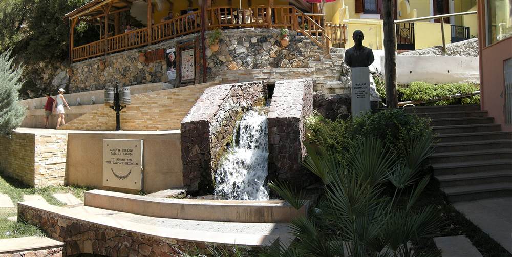
Spili is a green hillside village of stone houses, plane trees and running water. Cobbled lanes climb between old dwellings, tavernas and a Byzantine church, and the sound of spring water follows the visitor through the old core. It was built as the seat of the bishop of Agios Vasilios.
The village reads as a single organism grown into the mountain slope. Houses of dressed stone stack up the hillside, their walls carrying flowerpots and vines, their doors opening onto lanes too narrow for cars. Huge plane trees throw shade over the central square and the fountain wall, and beneath them the temperature drops even at midday. Water is the constant: it runs in the fountain trough, in channels beside the lanes and in the springs that give the whole place its damp green vigour, a contrast to the dry stone of the coast 30 kilometres north.
As the seat of the bishop, Spili carries a civic scale beyond that of a farming hamlet. The Byzantine church anchors the religious core, the old episcopal buildings frame the square, and the layout of cobbled streets follows the logic of a small town rather than a scattered settlement. Tavernas line the through-road and the square, serving mountain lamb, wild greens, cheese from the surrounding slopes and honey from the Amari hives, so a stop here doubles as a meal.
The pace is unhurried and the village stays lived-in rather than staged. Residents fill water bottles at the fountain, sit under the planes with coffee, and tend the gardens that spill down the terraces. A visitor walks the whole old core in half an hour of slow wandering, then lingers far longer over the water, the shade and the plates set down on a taverna table.
What is the Venetian lion-head fountain (Kefalovrysi) of Spili?
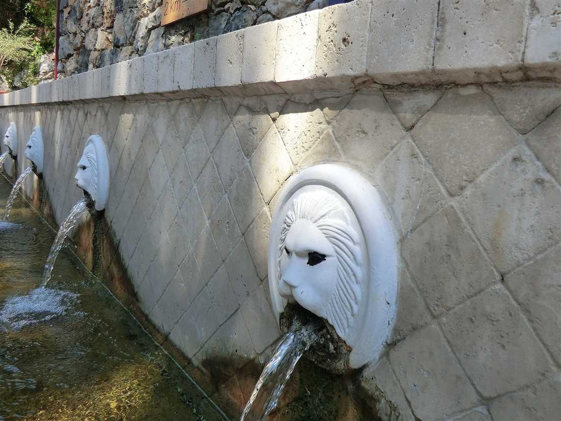
The Kefalovrysi is Spili’s centrepiece: a long stone wall set with a row of 25 carved lion-head spouts that pour cold spring water into a continuous trough, all shaded by huge plane trees. It is the image the whole village is known by across Crete.
The name Kefalovrysi means “head spring”, and the structure gathers the water of the mountain into one civic wall. Twenty-five lion heads, cut from stone and set in a line, each send a steady jet of spring water arcing into the long stone trough below. The water runs without pause, fed by the springs of Mount Vorizis, and stays cold through the hottest afternoons. The row of identical lions turns a functional watering point into a piece of civic sculpture, which is why photographs of the fountain stand in for the village itself.
The plane trees over the wall complete the scene. Their canopy holds the space in deep shade, the roots drink from the same water table that feeds the spouts, and the combination of running water and green shadow makes the fountain the coolest and liveliest spot in the village. Residents and travellers alike fill bottles straight from the lion mouths, and the taste of the spring water is part of what draws people off the road and into the old core.
The fountain also fixes Spili’s identity against every other mountain village on the route. Agia Galini has its harbour, Plakias its beach, the Amari its frescoed churches; Spili has the wall of 25 lions and the water they pour, a single unmistakable landmark that names the place. Standing before it, a visitor understands why the road from the coast is worth the climb.
What is nearby: the Amari valley, Preveli and Plakias?
Spili sits at the crossroads of southern Crete. The road on continues to Agia Galini, to Plakias, to the Preveli palm beach and through the Kourtaliotiko gorge, while the Amari valley and its mountain villages open to the north. The village is a natural base for the whole southern interior.
South and west of Spili the land drops toward the Libyan Sea, and the sights line up along the descending roads. Plakias spreads across a wide bay of sand and clear water, a resort village ringed by mountains. Beyond it, the Kourtaliotiko gorge cuts a dramatic ravine that the road threads through on the way to the coast, its cliffs rising sheer above the river. At the gorge’s mouth lies Preveli, where a river-fed palm grove meets the sea at one of Crete’s signature beaches, the palms marching down the valley to the sand.
To the east the road runs to Agia Galini, a former fishing harbour turned seaside village stacked above its port, where the boats and tavernas fill a compact bay. North of Spili the Amari valley spreads under the western flank of Psiloritis, a broad green basin dotted with stone villages, Byzantine churches carrying old frescoes, and olive groves climbing the slopes. This is the quiet heart of the island’s interior, and Spili is the gateway to it.
Because these roads all meet at or near the village, a car parked at Spili reaches beach, gorge, harbour and mountain valley in short drives, each under an hour. That radius makes the village more than a photo stop: it is a hinge on which a whole day, or three days, of southern Crete turns. Travellers building a wider itinerary from Chania use Spili as the point where the north-coast base meets the southern beaches and the mountain interior.
Is the trip from Chania to Spili worth it, and when to go?
The trip is worth it for the lion-head fountain, the green mountain village and the southern sights the road unlocks. Go in late spring or early autumn, when the springs run full, the plane trees are in leaf and the coast is not yet at its hottest. Set out in the morning to have the day in the south.
The value of the journey rests on what Spili delivers that the coast does not: cold running water, deep shade and an unhurried mountain village built around a single unforgettable landmark. Add the beaches, gorge and valley within a short drive, and the 90-kilometre run from Chania returns far more than a photograph of a fountain. A traveller who treats Spili as the anchor of a southern loop, rather than an isolated errand, gets the full worth of the 1.5-to-1.75-hour drive.
Season shapes the day. Late spring brings full springs, green slopes and wildflowers, with warm days and cool nights at 430 metres. Early autumn holds the warmth of the sea while thinning the summer crowds and softening the heat of the drive. High summer works too, and the fountain’s shade and cold water are at their best then, though the coastal leg runs hot and the roads carry more traffic. Winter turns the mountains wet and the southbound bus scarce, so the shoulder seasons hold the balance.
Timing within the day matters as much as the season. Leaving Chania in the morning puts the fast coastal leg behind before the heat builds and leaves the afternoon free for Plakias, Preveli or the Amari before the return north. Whether the trip runs by car in under two hours each way or by the two-leg KTEL chain through Rethymno, the village at the top of the climb rewards the effort with water, shade and the wall of 25 stone lions that no other place on Crete holds.
Spili sits at the hinge of the south. The village marks the point where the road from Rethymno divides toward Agia Galini, Plakias and the Preveli palm beach, so a stop at the fountain pairs naturally with a south-coast beach day or a loop through the Amari valley. Fill water bottles at the lion-head spouts, eat under the plane trees, and read the day trips from Chania guide to build the rest of the route around it. The green, watered core of Spili is a cool break on the drive south and a base for the mountain villages to the north.
Frequently Asked Questions
How do you get from Chania to Spili?
From Chania to Spili, drive east on the E75/A90 national road to Rethymno, then south on the inland road toward Agia Galini and Plakias, 90 kilometres in 1.5 to 1.75 hours. By bus, take the KTEL Chania to Rethymno, then the Rethymno to Agia Galini or Plakias bus, which stops at Spili.
How far is Spili from Chania?
Spili lies 90 kilometres from Chania in the Rethymno regional unit, 30 kilometres south of Rethymno town on the road to the south coast, at an altitude of 430 metres on the slope of Mount Vorizis. The drive takes 1.5 to 1.75 hours.
Is the trip from Chania to Spili worth it?
The trip from Chania to Spili rewards visitors with the Venetian lion-head fountain, a green village of plane trees and running water, and a gateway to the Amari valley and the south coast. It works both as a stop on the way south and a mountain base.