
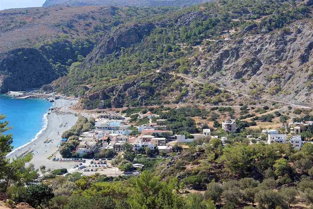
To get from Chania to Sougia, drive about 70 kilometres south-west over the mountains through the Selino villages of Agia Irini and Rodovani in about 1.25 to 1.5 hours, or take the seasonal KTEL bus, to the quiet pebble-beach village on the Libyan Sea. Plan the whole trip with Greece Tours.
This guide covers the trip from Chania to Sougia in full: where it is, how to get there by car, bus and ferry, the drive time, the village and its beach, the coastal ferry hub, ancient Syia and Elyros, the walk to Lissos, the Agia Irini gorge, the Samaria Gorge connection, the food, families, the best time, and whether this quiet south-coast trip is worth it.
Where is Sougia from Chania?
Sougia sits on the south-west coast of Crete in the Selino district of the Chania region, on the Libyan Sea about 70 km south of Chania town. It is a small, quiet village set in a bay below the mountains, with a long pebble-and-sand beach.
Sougia belongs to the municipality of Kandanos-Selino, the mountainous south-west corner of the Chania region. It faces the Libyan Sea, the stretch of water between Crete and North Africa, and looks out to open horizon rather than to another island. The White Mountains rise directly behind the village, so the settlement occupies a narrow shelf of flat ground between steep slopes and the shore.
The village is a low-key resort with no high-rise blocks and no large hotels. Rooms, studios and a line of tavernas run along the seafront and one short inland street. The beach forms the centre of the place: a bay of grey pebble and coarse sand, roughly 1 km long, with clear, deep water close to shore. A single road descends into Sougia from the north, ending at the sea.
Sougia stands near the ancient site of Elyros and the harbour town of Lissos, west along the coast in a small valley reached on foot. Its position on the roadless southern shore makes it both a destination and a transfer point: walkers, gorge-finishers and travellers heading to Paleochora or Agia Roumeli pass through it. The distance of about 70 km from Chania crosses the mountains rather than following the coast.
How do you get from Chania to Sougia?
Three routes link Chania to Sougia: a 70 km drive south-west over the mountains through Agia Irini and Rodovani in about 1.25 to 1.5 hours, a direct seasonal KTEL bus of about 2 hours, and the ANENDYK coastal ferry along the south shore from Paleochora or Agia Roumeli. A car is the easiest.
The road route leaves Chania heading south-west through Alikianos and climbs into the Selino hills. It passes the village of Agia Irini and the head of the Agia Irini gorge, then runs through Rodovani and Moni before dropping down a valley to the coast at Sougia. The full drive covers about 70 km on a paved but winding mountain road, and a hire car gives direct control over timing and onward trips.
The KTEL bus runs a direct seasonal service from Chania bus station to Sougia. The journey takes about 2 hours and operates a couple of times a day through the summer months, dropping passengers in the village beside the beach. Outside the summer season the timetable thins to a sparse schedule, so travellers check the KTEL Chania timetable before relying on it.
The third route reaches Sougia by sea. The ANENDYK coastal ferry connects Sougia west to Paleochora and east to Agia Roumeli, the exit of the Samaria Gorge, and on to Loutro and Chora Sfakion. Travellers without a car drive or bus to Paleochora, then sail east to Sougia, or finish the Samaria Gorge at Agia Roumeli and sail west. This suits walkers moving between points on the roadless coast.
How long does it take to drive from Chania to Sougia?
The drive from Chania to Sougia takes about 1.25 to 1.5 hours over roughly 70 km. The route runs south-west from Chania through Alikianos and the Selino hills, past the Agia Irini gorge, through Rodovani and Moni, then down the valley to the coast on a winding but fully paved mountain road.
From Chania the road heads inland to Alikianos, then begins the climb into the mountains of the Selino district. The gradient tightens as the road gains height, threading through olive groves and stone villages. The pace stays moderate because the bends are continuous rather than because the surface is poor; the asphalt runs the whole way to the sea.
Past the top of the climb the road reaches Agia Irini, where the Agia Irini gorge begins its cut down towards the south coast. The route continues through Rodovani, near the ancient city of Elyros, and through the small settlement of Moni. From here the road follows a valley that descends steadily towards the Libyan Sea, the last stretch dropping through a narrow gorge-like cut to the shore.
The final kilometres bring the road out at the back of Sougia, ending at the seafront by the beach. Drivers add time for the bends and for slow farm traffic in the villages, which is why the 70 km takes longer than the distance alone suggests. Fuel is limited on the south coast, so a full tank in Chania or Alikianos covers the round trip and any onward driving.
Can you take the bus from Chania to Sougia?
Yes. The KTEL bus runs a direct seasonal service from Chania to Sougia, taking about 2 hours and operating a couple of times a day through the summer. The bus drops passengers in the village beside the beach. The timetable is seasonal and turns sparse outside the summer months.
The service starts at the central KTEL bus station in Chania, near the city centre and a short walk from the old harbour. Buses to the south-west coast leave from marked bays, and the Sougia service follows the same mountain road as private cars, through Alikianos, the Selino villages, Rodovani and Moni before the descent to the coast.
The journey of about 2 hours runs longer than the car drive because the bus makes stops in the villages along the route to pick up and set down passengers. It terminates in Sougia at the seafront, within walking distance of the tavernas, rooms and the beach, so arriving travellers reach their accommodation on foot.
Through the peak summer months the service runs a couple of departures each day in each direction, which lets a day trip work with an early bus out and a late one back. The frequency drops sharply in spring and autumn and to a minimal schedule in winter, so travellers confirm the current KTEL timetable and plan the return leg before setting off.
What is Sougia village like?
Sougia is a quiet, laid-back village on a bay with a long grey pebble-and-sand beach and clear deep water. A handful of tavernas and rooms line the front, with no big hotels. It draws a relaxed, alternative-traveller crowd, and the mountains and the E4 path rise behind.
The heart of the village is its seafront. A single paved promenade runs along the back of the beach, lined with tavernas serving Cretan food, cafes and small guesthouses. Behind it one short street leads inland to a few more rooms and a mini-market. The scale stays small: the built-up strip measures a few hundred metres, and the mountains close in on both sides.
The beach stretches about 1 km, a mix of grey pebble and coarse grey sand that shelves into clear, deep water. The eastern end near the ferry jetty is the busiest; the shore grows emptier towards the west, where the beach passes below cliffs and naturism is the norm at the far end. The open bay catches the afternoon breeze off the Libyan Sea.
Sougia keeps a deliberately low-key character, favoured by walkers, campers and travellers after a plain coast rather than a resort. The European long-distance E4 path runs through the village, arriving over the mountains and continuing along the coast towards Agia Roumeli and Paleochora. This walking traffic, together with the ferry link, gives the village a steady flow of hikers alongside the beach visitors.
Is Sougia a ferry hub for the south coast?
Yes. The ANENDYK coastal ferry links Sougia west to Paleochora and east to Agia Roumeli, the exit of the Samaria Gorge, and on to Loutro and Chora Sfakion. Sougia is a scheduled stop on the roadless south-coast boat line, used by walkers and gorge-finishers moving between villages.
The southern coast of Crete between Paleochora and Chora Sfakion carries no through road. The villages along it connect to each other by the ANENDYK ferry, and Sougia sits in the middle of that line. Its jetty stands at the eastern end of the beach, and boats call there on a scheduled run rather than on demand, tying the isolated settlements into one transport chain.
Heading west, the ferry runs from Sougia to Paleochora, the larger town at the south-west corner with its own road to Chania. Heading east, it calls at Agia Roumeli, where the Samaria Gorge reaches the sea, then continues to Loutro and Chora Sfakion in the Sfakia district. Walkers finishing the Samaria Gorge sail west to Sougia, and E4 hikers use the boats to skip harder coastal sections.
This role turns Sougia into a transfer point as much as a destination. Travellers combine the boat with the bus and the mountain road: arrive by car or KTEL bus from Chania, sail east to Agia Roumeli for the gorge, or west to Paleochora for the onward road. The ferry schedule shifts with the season and the sea state, so travellers confirm the ANENDYK timetable at the jetty before planning a connection.
What is the ancient site of Syia at Sougia?
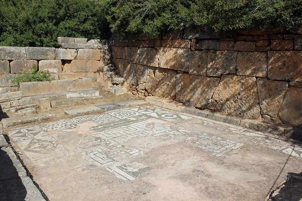
Sougia stands on ancient Syia, the coastal harbour of the Doric city of Elyros in the mountains above. Roman and early-Christian remains lie scattered through the village, the most striking a mosaic floor from an early basilica, all free to see on the spot.
Syia served as the sea gate of Elyros, the largest ancient city of south-west Crete, whose ruins sit 5 kilometres inland near the modern village of Rodovani. Goods, timber and traded cypress moved down the gorge to the Syia quay and out across the Libyan Sea to Cyrene and North Africa. The harbour peaked under Roman rule, when the settlement filled the flat ground behind the beach.
The clearest survival is the geometric mosaic pavement of a 6th-century basilica, kept under and beside the modern village church at the east end of the seafront. Fragments of walls, cisterns, aqueduct channels and rock-cut tombs sit among the houses and on the low slopes, and carved architectural blocks are built into later structures. Nothing is fenced or ticketed, so a slow walk through the lanes doubles as the archaeological tour.
The old name Syia derives from the Greek word for pigs, marking a place once known for its herds. Sougia keeps the site as a lived-in ruin rather than a museum, and pairs it with the wider circuit of west-Crete antiquity reachable on day trips from Chania. Bring water and stout shoes, since the interesting stone lies off the paved road.
What is the walk to Lissos from Sougia?
A marked coastal footpath climbs west out of Sougia over the headland and drops through a short gorge to Lissos, an ancient site set in a hidden green valley by the sea. The walk runs 1 to 1.5 hours each way, with a boat return as the alternative.
The path leaves the west end of Sougia harbour, rises across the rocky spur behind the beach, then descends into a wooded ravine thick with pine and cypress. The gradient is steady rather than steep, the surface is stone and gravel, and the route is waymarked with red paint and cairns. Spring water rises in the valley floor, which keeps Lissos green when the surrounding coast burns dry.
Lissos was a spa town famed across ancient Crete for its Asclepion, a healing sanctuary built around a mineral spring. The temple retains a mosaic floor of birds and geometric panels, and Doric column bases stand among the ruins. A necropolis of vaulted Roman tombs is cut into the hillside above, and two small Byzantine chapels sit lower down, one raised directly on the temple foundations.
Walkers reach Lissos on foot in both directions for a 3-hour round trip, or take the coastal ferry back to Sougia to save the return climb. The bay has a small pebble beach and no road, no shop and no shade beyond the trees, so carry water and food. The valley links to the wider south-coast trail network that threads Sougia to its neighbours.
How does Sougia connect to the Samaria Gorge?
Sougia is a base and a finish point for the roadless south coast. The coastal ferry east reaches Agia Roumeli, the exit of the Samaria Gorge, so walkers complete Samaria and sail to Sougia, while the Agia Irini gorge descends to the Sougia road itself.
The 16-kilometre Samaria Gorge runs north to south and ends at the shore hamlet of Agia Roumeli, which has no road out. Hikers finish the gorge, rest on the beach, then board the coastal boat that works the cliff-bound coast between Agia Roumeli, Sougia and Paleochora. The sailing from Agia Roumeli to Sougia takes around 45 minutes and threads a shoreline reachable no other way.
The Agia Irini gorge offers a shorter, quieter alternative that ends near the Sougia road. This 7-kilometre ravine drops from the mountains to a point on the Chania\u2013Sougia route, where a bus or a short transfer carries walkers the last stretch down to the sea. Many people pair the two, walking one gorge and returning by boat and bus through Sougia.
These links make Sougia a walkers’ hub rather than a dead end. A hiker parks or stays in the village, rides the morning boat east to start a gorge, and returns to the same bed by evening. The ferry timetable and the bus from Chania are set to meet, so the village works as a pivot for the whole south-west coast.
What beaches are near Sougia?
Sougia’s own beach is a long open bay of grey pebbles and clear deep water on the seafront. Quieter coves lie east and west on foot or by boat, Lissos bay sits an hour west, and the ferries open a string of shores towards Agia Roumeli.
The main beach stretches around 1 kilometre along the front of the village, backed by tamarisk trees that throw shade onto the pebbles. The shore shelves quickly into deep Libyan Sea water that reads a strong blue, and the exposed bay keeps the swimming cool and the crowds thin. The east end drifts into an unofficial naturist stretch below the ancient ruins.
West of the village the coastal path reaches small stone coves and then Lissos bay, a sheltered pebble inlet beneath the ancient sanctuary with no road access. East along the ferry line lie the beaches below Agia Roumeli and the cliff coves that only a boat reaches. A short walk in either direction from Sougia finds empty water within 20 minutes.
The pebble surface means no fine sand and firm footing underfoot, so water shoes earn their place. There are no sunbeds or bars strung along the sand, only the tavernas set back on the front, which keeps the beach plain and open. Sougia works as a base for the roadless south-coast beaches that the ferry unlocks in both directions.
When is the best time to visit Sougia and where do you stay?
Late spring to early autumn is the window, when the ferries and buses run a full timetable and the sea is warm. Sougia is a low-key village of rooms, studios and small tavernas with no large resorts, quiet and cheap outside the peak weeks.
From May to September the Chania bus, the coastal ferry and the tavernas all run daily, and the water holds swimming warmth into October. July and August bring the fullest boats and the hottest walking, so the gorge and Lissos paths suit the cooler shoulder months of May, June and September, when the trails stay green and the midday heat eases.
Accommodation is family-run rooms, self-catering studios and a handful of small guesthouses set among the gardens behind the front. There are no chain hotels, no nightclubs and no resort complexes, which fixes prices well below the north-coast towns and keeps evenings quiet. Most beds sit within a 5-minute walk of both the beach and the ferry quay.
Book ahead for the peak fortnight around late July and early August and for weekends through the summer, since the village holds few rooms. Out of season a bed is easy to find on arrival. Sougia pairs with a stay in Chania town for travellers who want the old harbour by night and the wild coast by day.
What is the Agia Irini gorge near Sougia?
The Agia Irini gorge is a 7 km walk that drops from the village of Agia Irini on the Chania-Sougia road down to the coast road near Sougia. It is a green, shaded, moderate 2.5 to 3 hour descent, gentler than Samaria.
The trailhead sits at Agia Irini village, 12 km north of Sougia at roughly 500 metres altitude, right on the main road in from Chania. The path threads a narrow ravine walled by pine and plane trees, and the shade holds through the heat of the day. Wooden bridges and stepping stones cross the streambed at the wet sections.
Springs feed the gorge along its length, and the sound of running water carries between the rock walls. The gradient is steady rather than steep, which makes the 7 km a walk for anyone with a reasonable level of fitness, not a scramble. Rest points with benches and shade sit at intervals down the route.
The gorge exits near Sougia, and a short link brings walkers onto the coast road into the village and its beach. Buses connect Agia Irini and Sougia, so a walker rides up, descends on foot, and swims at the end. It ranks among the finest day trips from Chania for a group wanting a gorge without the crowds and length of Samaria.
Is Sougia good for families and swimming?
Sougia suits families who swim. The water off the pebble beach is clear and deep, calm on still days with no big waves, and tavernas sit behind the sand. The pebbles and depth favour swimmers and older children over toddlers.
The bay shelves quickly into clean, cool water, which draws strong swimmers straight off the shore. On a windless morning the surface stays flat and the visibility runs four to five metres down. The pebbles keep the water free of stirred-up sand, so the sea reads glass-clear even at midday.
Water shoes make the pebble entry comfortable and steady the footing at the shoreline. The tavernas and cafes line the back of the beach, a few steps from the towels, which keeps lunch and shade within reach for a family. The whole front is low-key, safe and quiet, with no jet-skis or loud beach bars to break the calm.
The beach splits by mood along its length. The east end, nearest the village and the tavernas, is the family stretch. The far west end, past the headland, is the naturist section, screened and separate. Parents with young toddlers pick a sandier bay along the coast, since the depth here rewards children who swim already.
Where do you eat and what is the food in Sougia?
You eat at the tavernas along the seafront, which serve fresh fish, Cretan dishes, and produce from the Selino mountains, dressed in local olive oil and poured with local wine. The dining is laid-back and beachfront, with no fast food or resort chains.
The seafront tavernas run in a line behind the beach, tables set on terraces a few metres from the water. Fish comes off the day boats, grilled whole and priced by weight, alongside octopus and small fry. The kitchens plate Cretan staples: dakos rusks, wild greens, snails, lamb and slow-cooked goat.
The fertile Selino valleys inland supply the vegetables, herbs and fruit, and the mountain villages send cheese, honey and greens down to the coast. The olive oil is pressed from Selino groves, and the wine and raki come from local vines. The result is a plate rooted in the district rather than shipped in.
Nothing on the front is a chain. There are no burger counters, no franchise signs, no resort buffets, and the pace stays slow through a long lunch or a late dinner by the sea. A meal here pairs naturally with a night in the village before a ferry or a gorge walk out of Chania.
What is ancient Elyros above Sougia?
Elyros was the largest ancient city of south-west Crete, set in the hills near Rodovani 5 km above Sougia, with Syia as its port. The ruins crown a hilltop acropolis with an aqueduct and theatre, and the city minted its own coins.
Elyros stood on the flat-topped hill of Kefala, 5 km inland and uphill from the coast at Sougia. A Doric city, it grew into the leading power of the Selino region and held authority over the smaller settlements and harbours around it. Syia, the port down at today’s Sougia, handled its trade and shipping to the sea.
The site holds the outline of an acropolis, sections of a Roman aqueduct that carried water to the city, and the remains of a theatre cut into the slope. Fragments of walls, cisterns and building foundations spread across the hilltop among the terraces. The city struck its own bronze coinage, marked with a goat and a bee, proof of its independence and reach.
Elyros traded through Syia in olive oil, wine and worked bronze, and its wealth flowed down the same valley the road now follows to the coast. The ruins are open ground with no gate and no ticket, free to walk. A track from Rodovani village reaches the base of the hill, and the 5 km link ties the ancient city to its port at Sougia.
Is the trip from Chania to Sougia worth it?
Yes, for a quiet pebble beach, the ancient Syia and Lissos, the gorge walks and the ferry to a roadless coast. The trade-off is a 70-kilometre winding mountain drive to a small village with no resorts, which is the point of coming.
The reward is concentration. Within a 90-minute radius of one small bay sit two ancient sites, three gorges, a spring-fed healing sanctuary and a ferry line that reaches shores with no road. The village stays plain, the prices stay low, and the crowds thin the moment the last bus leaves, which suits travellers chasing the south coast rather than a strip of sunbeds.
The cost is the journey and the quiet. The mountain road from Chania takes 90 minutes of bends across the Selino mountains, the village offers no nightlife and no shopping, and services close early. Anyone wanting resort comfort, a sandy beach or a lively night looks elsewhere on the north coast; anyone wanting walking, ruins and empty water finds Sougia among the calmest of the south-coast bases.
Sougia earns its place as a hub in the west-Crete circuit, linking the Chania day trips to the Samaria Gorge and the roadless villages beyond. Treat it as a day for the beach and the ruins, or a base of a few nights for the gorges and the ferry, and the winding drive repays the effort either way.
Frequently Asked Questions
How do you get from Chania to Sougia?
From Chania to Sougia, drive about 70 kilometres south-west over the mountains through Alikianos and the Selino villages of Agia Irini and Rodovani in about 1.25 to 1.5 hours, take the direct seasonal KTEL bus in about 2 hours, or arrive by the ANENDYK coastal ferry from Paleochora or Agia Roumeli.
How far is Sougia from Chania?
Sougia lies about 70 kilometres south of Chania on the south-west coast in the Selino district. The drive takes 1.25 to 1.5 hours over a winding but paved mountain road through the Selino villages; the KTEL bus runs the route in about 2 hours in season.
Is the trip from Chania to Sougia worth it?
The trip from Chania to Sougia rewards visitors with a quiet pebble beach, clear deep water, ancient Syia and Lissos, the gorge walks and the ferry to the roadless south coast. The winding mountain drive to a low-key village with no resorts is the trade-off, and the point.