
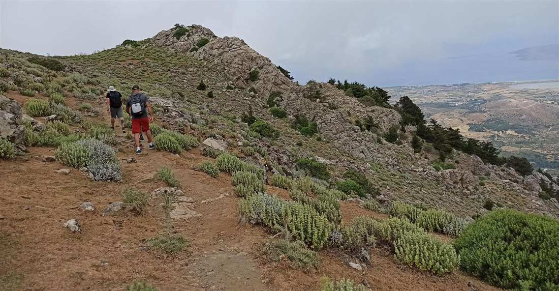
A Kos hiking tour climbs from the mountain village of Zia to the summit of Mount Dikaios, crosses the stone hamlets of Asfendiou and reaches the ruined castle of Old Pyli. Guided walks on other islands sit on Greece Tours.
This page covers the bookable hike, the routes, difficulty, coastal walks, seasons, kit and planning.
What is a Kos hiking tour?
A Kos hiking tour is a guided walk on the island’s mountain paths. Routes climb the Dikaios range above the north coast, pass the old hill villages on its slopes and cross the rocky south-west around Kefalos.
Kos island belongs to the Dodecanese, a chain of islands in the southeastern Aegean Sea. It sits off the coast of Asia Minor, the land that is now Turkey. The island measures 42.1 by 11.5 kilometres, so it is long and narrow. By area, it is the third largest island of the Dodecanese, after Rhodes and Karpathos.
No peak on the island stands higher than Mount Dikaios, so it is the natural target of a Kos hiking tour.
A Kos hiking tour covers one or more of three landscapes:
- The Dikaios range: paths on the slopes and ridges of Mount Dikaios.
- The hill villages: footpaths that link the settlements on the mountain’s flanks.
- The Kefalos peninsula: rocky, open ground at the island’s western end.
Which Kos hiking tour can you book?
One Kos hiking tour you can book on GetYourGuide is the Moderate Hiking Tour on Dikaios Mountain. It is a guided walk of 3.5 hours with free cancellation. Two evening trips to Zia run in the same mountains, but they are not hikes.
The full title on the card reads “Kos: Moderate Hiking Tour on Dikaios Mountain”. GetYourGuide lists it under the location Lagoudi Zia, named after two small villages on the mountain. You must book at least 10 hours ahead.
The card describes this Kos hiking tour as a walk through the landscapes of Mount Dikaios. It does not name a meeting point, a group size, a language or a list of inclusions. Check those details on the booking page before you reserve a place.
For an easier evening in the same range, two pickup trips head up to Zia instead. Neither card describes a hike, so neither counts as a Kos hiking tour.
- From Kos/Dikeo: Bus Tour to Zia Village on Mount Dikaios lasts 4 hours. Its card promises sunset views from Zia, the island’s highest mountain village, with an air-conditioned coach from set meeting points.
- Kos: Zia Village Sunset Tour with Hotel Pickup lasts 3 hours. Its card mentions a stroll through the village lanes, a café stop and Kos dishes at local restaurants.
Both trips offer free cancellation. The bus tour closes bookings 10 hours ahead, and the hotel-pickup tour closes 8 hours ahead.
Pick the Kos hiking tour if you want time on the trail, and pick a Zia trip if you want the views with little effort. For the rest of your stay, see our list of things to do in Kos.
What does a Kos hiking tour on Mount Dikaios cover?
A Kos hiking tour on Mount Dikaios explores the highest mountain on the island, which rises to 846 metres. The walk starts in Lagoudi–Zia, the highest inhabited spot on Kos and the foot of the climb. A small chapel crowns the summit.
In ancient times, Mount Dikeos carried the names Oromedon, Orion and Dikaion. Its modern name, Dikaios, is the Greek word for “righteous” or “just”. The summit holds the chapel of the Transfiguration of Christ the Saviour. One of the three municipal units of Kos also bears the name Dikaios.
The village of Zia sits on the mountain near the centre of the island. From its height, the view covers almost the whole northwest side of Kos. Zia is also known for its sunset, which walkers can watch after a Kos hiking tour.
Kos once formed part of a longer chain of mountains. Earthquakes and sinking land split it off in ancient times. Folds and faults in the rock set the long, narrow shape of the island. Kalymnos, across the sea to the north, is one remnant of that same chain.
Lagoudi and Zia are two settlements that form one semi-mountain village. Two water mills, one in Zia and one on the road to it, are listed historic monuments.
How hard is a Kos hiking tour?
A Kos hiking tour on Mount Dikaios carries a moderate grade, as the tour’s own title states. The climb from Lagoudi–Zia to the summit gains about 600 metres. The slopes are rugged, rocky and hard to cross, so steady fitness helps.
Lagoudi–Zia sits at 240 metres above sea level, so the rest of the height comes on foot. The mountain is built mainly from limestone and marble, with large masses of volcanic and granite-like rock. Around the summit, ravines cut across the main line of the ridge.
On 5 and 6 August each year, pilgrims climb these rough slopes to the summit chapel. A moderate grade sits between an easy stroll and a hard mountain trek. Walkers on a Kos hiking tour need steady legs for long uphill stretches and sure feet on uneven stone.
Summer heat on the island adds to the effort of any climb on the mountain. For less climbing, flat walks near the coast offer an easier day on the island. They involve almost no height gain.
On the way down, rough rock calls for sturdy boots with a firm grip. Trekking poles ease the strain on the knees during the descent of a Kos hiking tour.
Which villages can a Kos hiking tour pass?
A Kos hiking tour on the slopes of Mount Dikaios can pass the Asfendiou hamlets: Zia, Evangelistria, Lagoudi, Asomatos and the abandoned Haihoutes. Walkers see stone houses, narrow alleys, old churches and views down to the sea.
The Asfendiou villages lie about 14 km southwest of Kos town. Asfendiou has two main quarters, Evangelistria and Asomatos, while Zia and Lagoudi stand close by. Locals here grow vines and make olive oil. A Kos hiking tour links the hamlets through slopes fed by spring water.
The church of Asomatos dates back to the 11th century. Asfendiou also keeps the domed church of Panagia Evangelistria and the ruins of an early Christian basilica of Saint Paul. On a Kos hiking tour, traditional houses and stone towers stand along the way.
Haihoutes, also called Agios Dimitrios after its church, sits on the road from the Asklepieion to Zia, just before Asomatos. It has stood largely empty for decades. The church of Agios Dimitrios still stands among crumbling houses and wild plants.
Can a Kos hiking tour reach the castle of Old Pyli?
Yes, a Kos hiking tour can reach Old Pyli on a forest path of about 3 km from Pyli village. The ruined Byzantine castle crowns a hill at 300 m, with the abandoned medieval town around it.
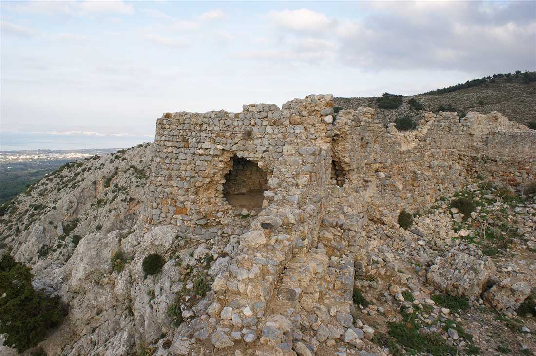
Pyli lies 15 km southwest of Kos town, among olive trees and fields. Its square has stone houses and old kafeneia. A fountain with six spouts flows near Saint Nicholas Square. On a Kos hiking tour, the forest path leaves the village and heads southeast to the castle.
Saint Christodoulos is credited with founding the castle and a monastery here in the late 11th century. He later founded the Monastery of Saint John on Patmos. The Knights of Saint John repaired the walls after an earthquake. An epidemic emptied the town in the early 19th century.
From the hilltop, the views reach Kalymnos, Pserimos and the Turkish coast. Panagia Kastriani served as the main church of the monastery of Saint Christodoulos. Inside the walls, a Kos hiking tour passes these remains:
- a rectangular gate framed by four semicircular arches
- seven towers and a large underground cistern
- the churches of Agios Antonios, Panagia Kastriani and Agioi Asomatoi
- frescoes in Panagia Kastriani, the oldest from the 12th century
Back in Pyli, the Harmyleio is a tomb from the 3rd century BC, about 300 m from the main square. Its twelve crypts sit six on each side, and a local family used it for ancestor worship. The small church of Timios Stavros stands directly above it.
Which coastal walks suit a Kos hiking tour?
A coastal Kos hiking tour follows the Kefalos peninsula in the south-west or the flat shore of the Alyki salt lake near Tigaki. Both routes stay close to the sea and suit walkers who want an easier day than a mountain climb.
Kefalos is the town at the western end of Kos, 43 km from Kos Town. It sits on a peninsula of the same name and keeps the ruins of a medieval castle. Nearby, the Bay of Kamari curves for about 2 km. At Kamari stand the ruins of Agios Stefanos, an early Christian basilica.
A Kos hiking tour on the west coast of the peninsula reaches Agios Theologos, about 7 km south-west of Kefalos village. The beach takes its name from the small chapel of St John the Theologian, close to the shore. The last stretch is a dirt road, and the shingle beach is known for its sunsets.
On the north coast, the Alyki salt lake lies about 400 m from Tigaki village. It once worked as a salt pan and is now a protected wetland. Flamingos gather on the water from winter into spring. In summer the lake dries out and leaves a white crust of salt.
A Kos hiking tour around the lake follows a flat track that circles the whole shore, with no steep climbs. Birdwatchers also look for herons along the edges. Flat walks like this are the easier choice next to mountain routes, and they suit children and first-time walkers.
Which season suits a Kos hiking tour?
Spring and autumn suit a Kos hiking tour, when days stay warm and dry enough for long walks. Summer brings hot afternoons, so walks start at dawn. Winter brings the heaviest rain of the year, from November to January.
Kos has a hot-summer Mediterranean climate. A weather station on the island records these average daily highs and monthly rain:
- January: 14.3°C high and 214.7 mm of rain
- April: 20°C high and 40.6 mm of rain
- July and August: 30.4°C and 31°C highs, with no rain
- October: 25.7°C high and 36.3 mm of rain
- December: 17.4°C high and 175.6 mm of rain
Late spring warms to a 25°C average high with only 7.2 mm of rain. A Kos hiking tour in late spring or October avoids both the summer heat and the winter rain. The whole year totals about 750 mm of rain, and November alone brings 106 mm.
In spring, poppies, anemones and wild daisies colour the fields, hills and roadsides of Kos. A spring Kos hiking tour passes these flowers on the open hills. For month-by-month planning, read our page on when to visit Kos.


What do you pack for a Kos hiking tour?
A Kos hiking tour needs grip underfoot, enough water and sun cover. Add a warm layer for the summit wind and food for energy. A charged phone and walking poles complete a safe kit. Keep both hands free.
- Boots or trail shoes with grip
- Water for the whole walk
- A sun hat and sunscreen
- A light windproof layer for the summit
- Snacks such as nuts or fruit
- A charged phone for maps and calls
- Walking poles for the descent
- A small first-aid kit with plasters for blisters and a bandage for a twisted ankle
Stay on the marked paths on a Kos hiking tour, since shortcuts erode the slopes. Dry months bring a real fire risk to the hillsides. Light no fires, carry no cigarettes and take all litter back down.
Turn back when strong wind or fog rolls in, because both hide the path. In an emergency, dial 112. It is the common emergency number across nearly all European Union states, Greece included. It reaches ambulance, fire and police services, and a GSM mobile phone can dial it even when locked.
Prefer two wheels to two feet? See our page on Kos cycling for rides across the island.
What do travellers ask about a Kos hiking tour?
How long does a Kos hiking tour take?
The moderate guided hike on Dikaios Mountain listed on GetYourGuide lasts 3.5 hours. Add the drive from your hotel to the meeting point and back, which depends on where you stay. Start early in summer, so the climb ends before the midday heat reaches the open upper slopes.
Can children join a Kos hiking tour?
The GetYourGuide card for the Dikaios hike lists a single adult ticket and gives no age notes, so check the card before you book with children. Young hikers need steady legs, proper shoes and the stamina for a mountain path with loose stone underfoot. Flat coastal walks suit younger children.
Do you need a guide for a Kos hiking tour?
You can walk the marked paths on your own with a map and a charged phone. A guide picks the right path at each junction, sets a steady pace and watches the weather. Solo walkers carry that job alone, so a guided group suits first-time visitors who do not know the mountain.
How do you reach Kos for a Kos hiking tour?
Fly into Kos International Airport “Ippokratis”, named for Hippocrates and located near the village of Antimachia. Public buses link the airport with Kos town, Mastichari and Kardamena. Ferries from Piraeus, the port of Athens, sail to Kos on the Dodecanese line to Rhodes. Our page on how to get to Kos has the full details.