
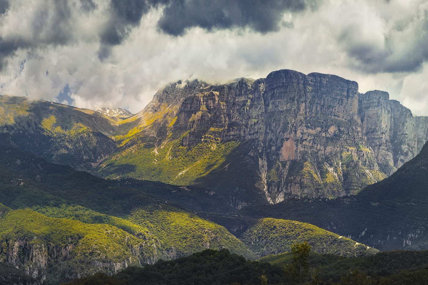
Papigo tours start in the twin villages of Megalo Papigo and Mikro Papigo, also spelled Papingo, in the Zagori area of the Ioannina regional unit in Epirus, below the Astraka towers of Mount Tymfi. The routes cover the stone villages, the Ovires rock pools, the Dragon Lake of Tymfi, the Vikos Gorge and the canyons around the villages. Greece Tours lists the hikes and day tours that start in Papigo and Ioannina.
This page covers what Papigo tours see in the villages and on the mountain, which hikes, canyoning trips and rafting runs leave from Papigo, how visitors reach Zagori, and which season suits each route. The tours below are checked on GetYourGuide and Viator and leave from Papigo, Mikro Papigo and Ioannina.
What do Papigo tours cover?
Papigo tours cover Megalo Papigo and Mikro Papigo, the twin villages of the Papigo municipal unit in Zagori, the Ovires rock pools on the Rogovo stream and the history of Zagori self-rule, all inside the Vikos–Aoös National Park in Epirus.
Papigo, also written Papingo or Papigko, belongs to the municipality of Zagori, and Papigo tours start in its two villages, Megalo (greater) Papigo and Mikro (lesser) Papigo. The village sits very near the northern end of the Vikos Gorge and draws hikers and mountaineers from around the world.
Both villages stand at the base of Mount Radovoli, part of the Tymfi massif. The World Wide Fund for Nature (WWF) runs an information centre in Papigo, and certified hiking guides work the Tymfi trails. Papigo tours form one branch of the wider Zagori tours, which span a region of about 1,000 square kilometres with 46 villages.
- Region: Ioannina regional unit, Epirus, northwestern Greece.
- Area: the Papigo municipal unit covers 34.131 square kilometres.
- Residents: the 2021 census counted 184 people in Megalo Papigo and 39 in Mikro Papigo.
- Park: the Vikos–Aoös National Park, founded in 1973, covers 12,600 hectares.
What do Papigo tours see in Megalo Papigo and Mikro Papigo?
Papigo tours walk the cobbled lanes of Megalo Papigo and Mikro Papigo, two settlements at 950 to 960 metres declared traditional in 1978, past stone mansions, churches dated from 1774 to 1852 and the Astraka cliffs that rise above both villages like towers.
Megalo Papigo stands on the western slopes of Mount Tymfi and counts as one of the defining examples of Zagori architecture. Papigo tours pass Zagorian mansions, stone arches, village squares and cool fountains. Zagori houses have walls of local stone up to a metre thick.
House roofs carry stone tiles of limestone or sandstone, held without cement by the weight of the tiles above, and heavy winter snow keeps them in constant need of upkeep. The main village churches of Zagori are stone basilicas with wooden roofs covered by slate. Papigo tours visit three churches in Megalo Papigo and one monastery outside it:
- Agios Vlasios: dates from 1852 and stands on the foundations of an older church from 912.
- Agios Georgios: dates from 1774 and gained a renovation in 1880.
- Panagia: carries a reported date of 1774.
- Agia Paraskevi: stands near the main road into the village as a Byzantine foundation.
Mikro Papigo has stone mansions, ornate courtyard gates, cobbled paths and fountains. Its 18th-century church of the Archangels Michael and Gabriel, known as the Taxiarchs, holds a wooden screen made by Epirote craftsmen and began as the chapel of a monastery, now its only remaining building. Above both villages rise the cliffs of Astraka, a 2,436-metre peak of Mount Tymfi, known in Greek as the Pyrgoi Astrakas, the Astraka Towers.
What do Papigo tours see at the Ovires rock pools?
Papigo tours stop at the Ovires of Rogovo, also called the Kolymbethres, a chain of natural rock pools cut into limestone by the Rogovo stream, 1 km from Megalo Papigo on the road to Mikro Papigo, where the water stays very cold.
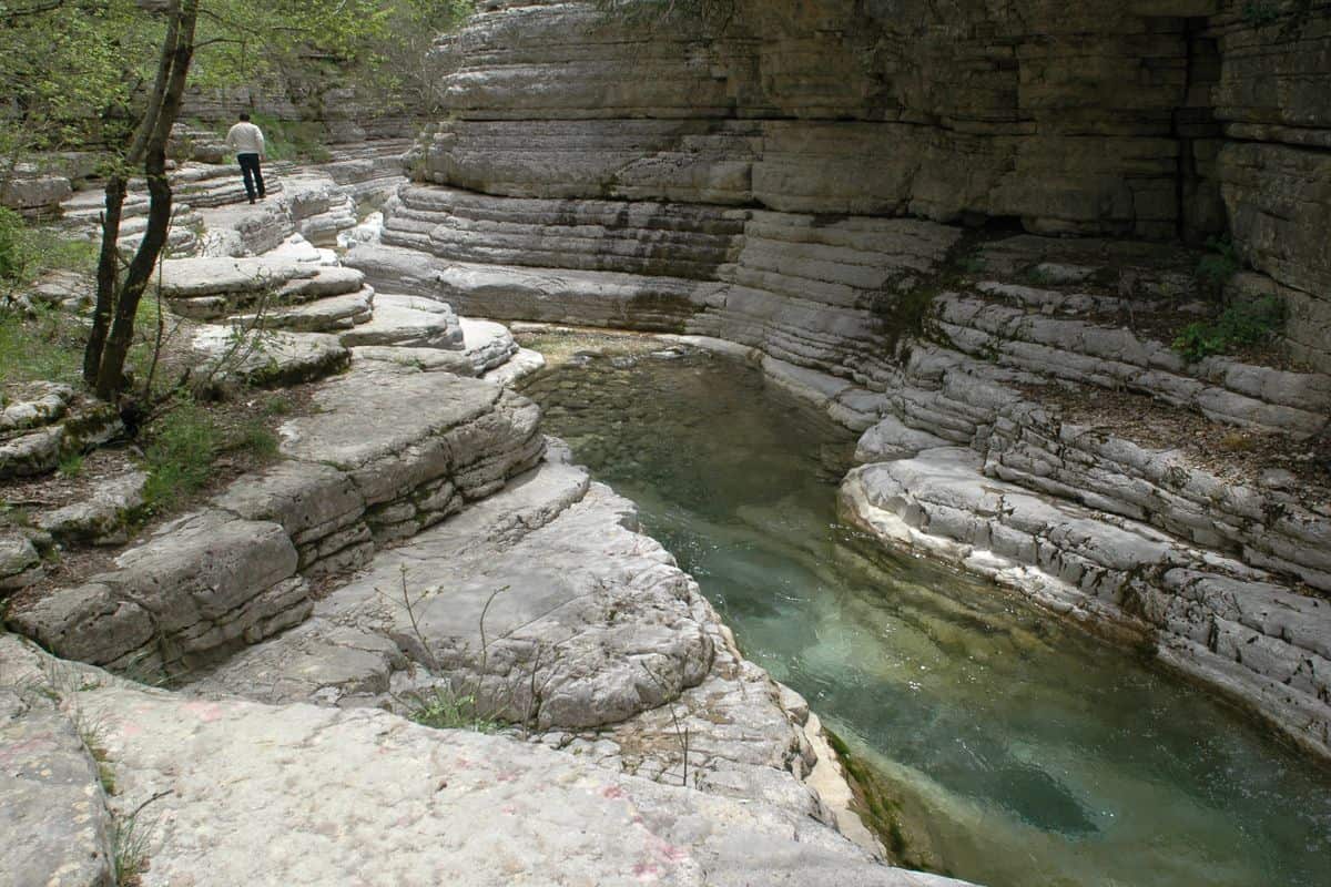
Kolymbethres is Greek for “baptismal fonts”, and the official Greek name is Ovires Rogkovou. Rogovo is the name of the stream, while Ovires is the local word for the natural ponds it fills. Papigo tours show the large hollows the stream opened in its rocky bed, which fill with water like fonts.
The Rogovo stream starts at 2,254 metres, on the western peak of Mount Tymfi, and runs past Mikro Papigo and Megalo Papigo. Mount Tymfi is largely Palaeocene-Eocene limestone, and the pools formed in that limestone through erosion by the stream.
In summer, Papigo tours give visitors time to cool off in the pools, although the water is very cold; in winter the water freezes. According to historical sources, Ali Pasha chose the Ovires of Rogovo for his summer baths. A natural pool with clear water also lies on the road before Mikro Papigo.
What history do Papigo tours tell?
Papigo tours trace a village first recorded in a Byzantine bull of 1325 that became the capital of Zagori after the Ottoman conquest of 1430, lost its privileges in the 19th century and now sits in the Zagori Cultural Landscape on the UNESCO list.
Papigo tours pick up the story in 1399, when the Greek population of Zagori and Papigo joined Esau, the Despot of Epirus, in his campaign against Albanian and Aromanian tribesmen. At the start of the 15th century, the Chronicle of the Tocco reports that Leonardo Tocco was on hand to rescue the people of Papigo from a Turkish attack. Papigo kept its own military and administrative structure into the early Ottoman period.
- 1430: Zagori, then 14 villages, falls to the Ottomans under Sultan Murad II and trades tax for autonomy.
- 1431: the Koinon of the Zagorisians forms after a treaty with Sinan Pasha.
- 1670: a new treaty reformalises the Koinon, with privileges known as Surutia.
- 1868: the Sultan rescinds the Surutia in full.
- 1913: Zagori wins liberation during the Balkan Wars.
Papigo prospered from the 15th to the 17th century on these privileges, and in the 17th and 18th centuries local folk healers, the Vikos doctors, treated disease with local herbs. A Greek school ran in the village from 1780. Michael Anagnostopoulos (1837–1906), director of the Perkins Institution and Massachusetts Asylum for the Blind, funded the Kallineios School of 1897, which houses his library.
In the Second World War the area saw fighting between German forces and the partisans of Napoleon Zervas, and German reprisals burned villages of Zagori. Papigo tours recall that both villages suffered in that war and in the Greek Civil War of 1946–1949, and by the 1980s they stood almost empty; tourism has since brought residents back.
In September 2023, UNESCO added the Zagori Cultural Landscape to the World Heritage List under criterion (v). Papigo tours explain what the listing protects: villages transformed by remittances from expatriates in the 18th and 19th centuries, a Presidential Decree of 1979, amended in 1995, covering traditional villages built before 1923, and a municipality with about 93 percent of its land inside the North Pindus National Park.
Which Papigo tours hike to the Dragon Lake of Tymfi?
Papigo tours to the Dragon Lake of Tymfi start in Mikro Papigo and walk to Drakolimni, a glacial lake at 2,050 metres where alpine newts live. The hike takes 4 hours from Mikro Papigo, or 1 hour from the Astraka refuge.
From the main village, Papigo tours walk about 5 hours to reach the lake, and the shore is reachable on foot only. The last leg leaves the Astraka hut and runs a further 2.8 km to the northeast. This stretch has no signposts, so walkers follow red dots painted on rocks and small signs fixed to wooden poles. The round trip from the hut takes 2 hours.
Drakolimni means Dragon Lake in Greek. The lake formed after the retreat of the glaciers that covered the area 10,000 years ago, and it lies on an alpine meadow of Tymfi. Its shape is elliptical and its surface covers 1 hectare. It was once said to be 200 metres deep and linked to the underground water network of the mountain, yet Papigo tours find a lake with a maximum depth of 4.95 metres.
A local folktale explains the name: dragons lived in the lakes and fought each other by throwing pines and rocks, and their battles shaped the landscape. The alpine newts of Drakolimni (Ichthyosaura alpestris) are tied to these tales of dragon battles, and Papigo tours stop at the shore to look for them in the water. In Greece this amphibian lives only above 1,200 metres, and the country has its own subspecies, I. a. veluchiensis. Yellow-bellied toads (Bombina variegata) also live around the lake.
- Astraka: rises to the southwest of the lake.
- Ploskos: stands to the southeast at 2,377 metres.
- Gamila: rises to the east-southeast.
- Monastery of Stomio: lies to the north, 3.5 hours away on foot.


What do Papigo tours see at the Astraka towers and the Astraka refuge?
Papigo tours see the Towers of Astraka, huge rock walls that rise straight above Mikro Papigo, and rest at the Astraka refuge, a mountain hut at 1,950 metres below the peak. The hut is a meeting point for the mountain trails of Tymfi.
In Greek the cliffs are called Pyrgoi tis Astrakas, the Towers of Astraka. Their steep rock faces rise over Papigo like towers, and Papigo tours set off from Mikro Papigo right below them. The Astraka peak reaches 2,436 metres and dominates the Tymfi plateau on its northern face. Its name is a Greek word for the eaves of a roof, borrowed from Slavic.
Papigo tours reach the refuge on the simplest and busiest ascent route of the mountain. It starts in Mikro Papigo at 980 metres and runs about 6 km to the hut as part of the Greek national trail O3. Red diamonds on white, plus red dots and arrows on rocks and tree trunks, mark the path. The climb from Papigo to the hut takes 2 to 3 hours.
The refuge goes by three names: the Mountain Hut of Tymphe, the Astraka hut and the D. Georgoulis hut. It stands on the pass between the peaks of Astraka and Lapatos, and it runs through the summer months. Solar panels let it work all year, and winter stays need an appointment. For Papigo tours, the hut is the base for both the lake and the summits.
Around Papigo, near the Astraka and Gamila peaks, Papigo tours pass vertical caves and chasms with names drawn from mythology. Caving teams still study and explore them.
- Provatina: 408 metres deep, found in 1965 by the Cambridge University Caving Club.
- Chasm of Epos: 451 metres deep, drains water from the plateaus above.
- Hole of Odysseus: a vertical cave named after the hero of myth.
- Astraka climbing field: 30 routes on the northwestern and northeastern faces.
Which Papigo tours climb Mount Tymfi and Gamila?
Papigo tours climb Mount Tymfi from the Astraka refuge to Gamila, its highest peak at 2,497 metres, on a 6 km leg to the southeast. Tymfi is a limestone massif of the northern Pindus, and Gamila means camel in Greek.
Tymfi rises in the Zagori region of Ioannina, just south of the 40th parallel. The massif runs 20 to 25 km from east to west and about 15 km from north to south. Its southern slopes are gentle, while the north side breaks into cliffs up to 400 metres high. From west to east, the summits form a high plateau that Papigo tours cross on the way to Gamila.
- Gamila II: 2,480 metres.
- Karteros: 2,478 metres, a name meaning mighty.
- Megala Litharia: 2,467 metres, a name meaning big rocks.
- Tsouka Rossa: 2,379 metres, Aromanian for red peak.
- Goura: 2,466 metres, a word for a mountain spring.
Glaciers covered the uplands of Tymfi about 28,000 years ago, in the Late Quaternary. Papigo tours on the Astraka-Gamila plateau cross one of its best-developed glacial landscapes. The plateau holds more alpine lakes beyond Drakolimni, and part of them dry out in summer. Rizina, another alpine lake of Tymfi, lies about 4 hours on foot from the village of Vradeto.
Papigo tours take the shorter line from the west, while longer routes reach Gamila from other villages, on rougher and steeper ground suited to experienced hikers. A 12.8 km trail climbs from Vrysochori on the east side through the Karteros Pass, and the trail from Vradeto in the south runs about 14.9 km, a 7-hour walk. The southwestern slopes of Tymfi end in the canyon below, so hikers who want the gorge can follow our Vikos Gorge hike.
The first recorded climb on Tymfi took place on 7 and 8 June 1956, when Giorgos Michailidis and Giorgos Xanthopoulos climbed the face of Gamila. On 25 and 26 August 1960, Guido Magnone and Spyros Antypas climbed its northeastern face. The mountain now has 17 climbing fields: the northeastern face of Gamila counts 8 routes, Gamila II counts 6 and Tsouka Rossa counts 19. Climbers on Papigo tours meet old routes where pitons can be compromised or missing, and isolated spots that rescue teams find hard to reach.
Which Papigo tours cross the Vikos Gorge?
Papigo tours cross the Vikos Gorge on foot, on the trail that drops from Monodendri, runs north through the gorge to the Voidomatis springs and climbs out to Papigo or Vikos village. The full crossing takes six to seven hours, at medium difficulty.
The gorge on Papigo tours lies on the southern slopes of Mount Tymphe, in the Pindus Mountains of northwestern Greece. It runs for 32 km, with walls from 120 to 1,350 m deep and a width of up to 2,500 m. The Guinness Book of Records lists Vikos as the deepest canyon in the world in proportion to its width.
Papigo tours walk inside the core zone of the Vikos–Aoös National Park, which holds 12 km of the gorge. The Vikos Stream and its continuation, the Voidomatis River, carved the rock over millions of years. Young Eocene limestone forms the top 200 m of the walls, and grey Jurassic dolomite dominates the deepest layers. In the middle of the main part, far from roads and villages, Megas Lakkos cuts in as an equally deep secondary gorge.
Monodendri, the starting village, stands at 1,060 m, 41 km north of Ioannina. Its Monastery of Agia Paraskevi, founded in 1412, sits on the rim of the Vikos Gorge. The village also holds the “stone forest”, a group of huge rocks that rise like steep trees, with layer upon layer of stone.
The stream of the gorge is seasonal and turns permanent only at the lowest part, where the Voidomatis River forms at the end of the main gorge. Papigo tours reach that point at the springs, then take the path out to Papigo on the north side of the gorge.
- Oxia: a natural viewing platform over the deepest part of the gorge, 8 km by road from Monodendri.
- Beloi: a viewpoint on the eastern side of the gorge, reached from the village of Vradeto.
- Voidomatis springs: the turning point of the walk, below the village of Vikos.
- Vikos village: the southern exit, at 770 m on a hill above the gorge, part of the community of Aristi.
Which Papigo tours go canyoning near Papigo?
Papigo tours go canyoning in the Nefeli canyon in Papigo, Zagori, a gorge with a continuous river flow through the year. Guided routes last 3.5 to 7 hours and feature 4 to 8 rappels down waterfalls, plus jumps and natural slides.
The water on these Papigo tours comes from fountains that begin under the Astraka and Tsouka peaks and the Astraka tower. They drain into Nefeli all along the canyon and feed a dense flora that covers a large portion of it.
Active Nature runs two Papigo tours in the canyon. The easy route starts with a 20-minute hike from Papigo village and finishes with a 35-minute hike out. The medium route starts after a 15-minute hike and finishes with a 45-minute hike, with small jumps, waterfalls and natural slides between the rappels. Both routes demand average fitness and swimming.
Alpine Zone starts its Papigo tours at the central parking lot of Megalo Papigo, with a maximum of 12 participants. A 10-minute walk leads to the first rappel site. The beginner day ends with a climb up a wind ladder, a last rappel from 17 m and a 30-minute walk back to the village, and cave exploration and cliff jumping stay optional.
- Easy route: 3.5 hours, 4 rappels of 5 to 18 m, from age 8.
- Medium route: 5 hours, 8 rappels of 5 to 24 m, from age 14.
- Beginner trip: 5 hours, 4 rappels of 4 to 17 m, from age 5.
- Intermediate trip: 7 hours, 8 rappels of 17 to 30 m, from age 8.
Guides on Papigo tours supply neoprene suits, helmets, harnesses and ropes, and Active Nature adds free GoPro photos and video. Alpine Zone also runs an intermediate 7-hour trip at Deos Canyon in the Vikos–Aoös National Park. Routes beyond Nefeli are on our Zagori canyoning page.
Which Papigo tours go rafting on the Voidomatis river?
Papigo tours raft the Voidomatis on a 6 to 7 km stretch from the Aristi bridge to the Kleidonia bridge. The route is Class I to II, the ride lasts 1.5 to 2 hours, and the minimum age is 8, with swimming required.
The Voidomatis is a tributary of the Aoös with a total length of 15 km. Its main sources lie below the village of Vikos, and it ends close to Konitsa. The name means “the eye of the ox”, because oxen have clear blue eyes, like the waters of the river.
Papigo tours on the water paddle one of the cleanest rivers in Europe, part of the Vikos–Aoös National Park since 1973. The average water temperature does not exceed 4 °C, and the river carries a difficulty rating of 1 out of 5 for canoe-kayak and rafting. Over 100,000 people visit the park each year for rafting, canoe-kayaking, hiking and mountain biking.
Rafting Papigo tours launch at Bridge Aristi. Aristi is one of the 46 historic villages of Zagori, at 642 m and 48 km northwest of Ioannina. Halfway down, the Active Nature route stops at the Ayioi Anargiroi monastery, which dates back to the 16th century, and then passes through the Voidomatis canyon.
The finish is the single-arched stone bridge of Kleidonia, built in 1853 at the exit of the Voidomatis gorge and the best-known stone bridge on the river. The village of Kleidonia stands on the right bank, and two caves near it, Kleidi and Megalakkos, hold remains from 20,000 to 12,000 years ago.
- Total time: 3 hours for the whole activity.
- Briefing: 20 minutes before the start on Alpine Zone Papigo tours.
- Gear: helmets, life jackets, neoprene shoes and paddles.
- Winter extras: gloves and a fleece on cold days.
- Midway stop: a swim in waterfalls or a visit to cultural monuments.
Alpine Zone runs its Papigo tours on the river as class 2 whitewater, a 2-hour ride that suits first-timers and hardcore rafters alike. More on the river sits on our Voidomatis river rafting page.
Which Papigo tours visit the stone bridges and villages of Zagori?
Papigo tours that cover the stone bridges head south into central Zagori. The main stops are the three-arched Plakidas (Kalogeriko) bridge and the single-arched Kokkoris bridge near Kipoi and Koukouli, plus the stone-built villages of Monodendri, Vikos, Aristi and Vradeto.
More than 160 arched stone bridges were built across greater Zagori, mainly in the 18th and 19th centuries, by local master craftsmen using local stone. Until roads opened in the 1950s, the bridges were the only link to the outside world, and Papigo tours still cross them on foot. Sixteen bridges and seven churches in the national park area are listed historical monuments.
- Plakidas (Kalogeriko): built in stone in 1814 by Abbot Serafeim of the Prophet Elias monastery of Vitsa, repaired in 1863 by Andreas and Alexandros Plakidas, with arches of 15, 13.5 and 11.2 metres.
- Kokkoris (Noutsos): built in 1750 with funds from Noutsos Karamisinis of Vradeto, named after Grigoris Kokkoros, who ran a mill beside it; its single arch spans 23.6 metres and rises 13.3 metres.
- Kipoi bridges: Kontodimos at the village entrance, Milos down by the old water mill, and Petsonis on the way out towards Fragades.
Kipoi, the base for these bridges on Papigo tours, sits on a rocky hill at the southern end of the Vikos Gorge, at 800 metres, the lowest village in Zagori. The museum of collector Agapios Tolis there holds more than 40,000 exhibits. Next door, Koukouli, at 895 metres, keeps a building complex with five fountains, the old school and the church of the Dormition.
Papigo tours reach Monodendri at 1,060 metres, where the Rizarios Exhibition Center and Handicraft School are bequests of the Rizaris brothers. The monastery of Agia Paraskevi, founded in 1412, sits on the edge of the Vikos Gorge. Vikos village stands on a hill above the gorge, and Aristi, at 642 metres, is a listed traditional settlement a short way from the Spiliotissa monastery, founded around 1579.
Papigo tours that climb higher add Vradeto, at 1,340 metres the highest village in Zagori. Until a road opened in the 1970s, the only way up was the Skala of Vradeto, a stone stairway of about 1,000 steps on the side of a canyon. For the road loop through these villages, see the Zagori jeep tour.
What wildlife do Papigo tours find in the Vikos–Aoös National Park?
Papigo tours cross the Vikos–Aoös National Park, home to brown bears, wolves, roe deer, otters and the rare chamois. The park records 121 bird species, including griffon and Egyptian vultures, and 873 vascular plants, from plane forest to tall junipers around Papigo.
The park that Papigo tours cross spans 12,600 hectares between 550 and 2,497 metres and is one of the last European strongholds of the brown bear. Wolves, foxes, wild horses and roe deer live here all year, while otters and the rare wild cat keep to the area around Mount Tymfi. In the forest of Vrysochori, the second largest in Zagori, wild pigs and bears are native.
The chamois (Rupicapra rupicapra) is the park’s special attraction. Papigo tours scan for it on the rocky cliffs of the gorges, for example in Megas Lakos, a side ravine of the Vikos Gorge. The WWF office in Papigo plays a key role in park management.
- Birds of prey: griffon vulture, Egyptian vulture, peregrine falcon and common kestrel, out of fifteen raptor species.
- High-mountain birds: alpine chough, shore lark, western rock nuthatch and alpine swift.
- Rare forest birds: hazel grouse, Tengmalm’s owl, wallcreeper and willow tit.
- Grasslands above 1,500 metres: the Mediterranean golden eagle.
Birdwatchers on Papigo tours look for 26 species of conservation priority. The threatened Vipera ursinii lives in the subalpine meadows, yellow-bellied toads are common around the high lakes of Tymfi, and brown trout, roach and barbel swim in the rivers.
Of the 873 vascular plants, more than 250 are medicinal, aromatic or poisonous, and endemism reaches 23% for Balkan and 5.8% for Greek species. Junipers such as Juniperus communis, J. oxycedrus and J. excelsa cover the slopes around Papigo, and J. foetidissima tops 10 metres in the upper hills. Papigo tours through Koukouli can see 2,500 dried local plants and herbs in its natural history museum.
Which local food do Papigo tours taste?
Papigo tours taste the dairy-based food of Epirus: pies of handmade filo filled with cheese, spinach, eggs or zucchini, feta, galotyri and kefalograviera cheeses, trahanas, hilopites pasta and spit-roasted lamb, with tsipouro and mountain tea brewed from Sideritis raeseri.
Epirotic cuisine, the cooking of Zagori’s region, rests on dairy: butter and a long list of cheeses. Its pies include kasiopita (also called kikitsopita), kothropita, kimadopita, pepeki, kasiata and blatsaria. Papigo tours eat in the village tavernas, which serve traditional food, coffee and spirits.
- Feta: white brined cheese of sheep’s milk, or sheep’s milk with up to 30% goat’s milk, a PDO product since 2002.
- Galotyri: a thick, creamy product of very fatty sheep’s milk, taken 4 to 5 months after lambing, that counts as neither cheese nor yoghurt.
- Kefalograviera: a hard, salty PDO table cheese of sheep’s milk, or sheep’s and goat’s milk, made in Epirus and fried as saganaki.
- Other Epirus cheeses: anthotyros, kefalotyri, vasilotyri, tyrogliata and ourda.
In Vrysochori, northern Zagori, the only pie feast in Zagori falls on the first Saturday after 15 August: village women open handmade filo, fill it with cheeses, spinach, eggs or zucchini, bake it in wood ovens and share it in the square. Papigo tours in late July can join the village’s 26–28 July feast, where homes offer tsipouro and loukoumia and families roast lambs on open spits.
Two staples fill out the table on Papigo tours. Trahanas is cracked wheat with fermented milk, cooked as a thick soup, and hilopites are egg pasta of flour, eggs, milk and salt, served with rooster in red wine sauce. Kontosouvli and loukaniko sausage cover the meat side, and Epirus supplies more than 45% of the meat on the Greek market. Desserts include amygdalopita, spoon sweets, klostari and stegnopita, a dry pie, while the park’s slopes grow Sideritis raeseri, known in Greece as mountain tea.
How do visitors reach Papigo on Papigo tours?
Papigo tours start from Ioannina, the capital of Epirus, because both Papigo villages lie inside the Vikos–Aoös National Park, 30 kilometres north of the city. Travellers arrive by air at Ioannina National Airport, by the A2 Egnatia Odos motorway, or by ferry at Igoumenitsa.
Papigo tours that begin by plane land at Ioannina National Airport, named King Pyrrhus and coded IOA, four kilometres from the city centre. From Athens the flight lasts 45 minutes, against 4½ hours by car and 6 hours by bus over 430 kilometres.
The A2 motorway runs 670 kilometres from the port of Igoumenitsa to Kipoi on the Greek–Turkish border, past Ioannina and Metsovo, through 76 tunnels and over 1,650 bridges. Ferries from Ancona, Bari, Brindisi and Venice in Italy dock at Igoumenitsa, and hourly ferries cross to Corfu in 1.5 hours, so Papigo tours suit travellers who arrive by sea.
The last stretch of Papigo tours runs by road, and visitors to Zagori arrive mainly by rental car from Ioannina. A narrow winding road climbs to the villages after it crosses the Voidomatis River. KTEL buses from Ioannina to the Zagori villages do not keep a regular schedule.
- Igoumenitsa bus: KTEL runs 5 daily trips between Igoumenitsa and Ioannina.
- Thessaloniki drive: the road trip to Ioannina takes 2½ hours.
- Zagori roads: modern roads reached the Zagori villages only in the 1950s.
When do Papigo tours run best?
Papigo tours run in all four seasons, in a Mediterranean climate that shifts toward a continental pattern. Summer brings a dry spell of two to three months and stable, warm weather, while winter brings heavy snowfalls, high precipitation and extremely low temperatures.
Measured across the Vikos–Aoös National Park, the climate of Papigo tours gives a mean annual temperature of 11.9 °C and 1,100.9 mm of annual precipitation. The gap between mean maximum and mean minimum annual temperatures exceeds 40 °C.
Ioannina, the gateway city, has recorded an absolute minimum of −13 °C and an absolute maximum of 42.4 °C. Mountain weather around Zagori stays unsteady, with rain and low temperatures that surprise visitors who know Greece only from sunny beaches.
- Winter: snow covers the villages, and wood smoke rises from house and taverna chimneys.
- Spring: snow in the nearby mountains starts to melt at the end of February.
- Summer: visitor numbers peak, and the weather turns warm enough for a swim in rivers and lakes.
- Autumn: the foliage turns red, copper and vermilion, then covers the paths in a thick carpet.
River levels on Papigo tours follow the snow. After the February melt, rivers and streams return to a fast flow carrying pieces of ice. The Voidomatis River keeps a year-round flow, and its water stays so cold even in mid-summer that a swim lasts only seconds.
Which Papigo tours combine Ioannina and Metsovo?
Papigo tours combine with Ioannina for its lakeside castle, the inhabited island in Lake Pamvotida and the Perama Cave, and with the town of Metsovo, the largest centre of Aromanian (Vlach) life in Greece, set at 1,160 metres in the Pindus mountains.
Papigo tours that add Ioannina tours begin at Ioannina Castle, on a rocky peninsula of Lake Pamvotis at the south-eastern edge of town, where the Byzantine walls date to the 10th century. Its south-eastern citadel, Its Kale, holds the Fethiye Mosque, the tomb of Ali Pasha and the Byzantine Museum.
Lake Pamvotida, the largest lake in Epirus, lies at 470 metres, and a regular boat service crosses to Ioannina Island, 800 metres long, 500 metres wide and one of only two inhabited lake islands in Greece. Ali Pasha was killed there in 1822 at the Monastery of Saint Panteleimon, and the Filanthropinos Monastery dates from 1291 or 1292.
The Perama Cave lies beside the lake, four kilometres from Ioannina, and was found by chance in 1940, during the Second World War. It became the first cave in Greece arranged for tourists. It covers 14,800 square metres, and its visitor route runs 1,100 metres.
Papigo tours that continue to Metsovo tours reach a town famous for its Metsovone and Metsovela cheeses and the Katogi vineyard of the Averoff family. The Tositsa Folklore Museum has shown carved furniture, weavings and gold-embroidered costumes since 1955, and the Averoff Gallery opened in 1988.
- Ioannina synagogue: the old Jewish synagogue inside the castle walls ranks among the oldest and largest of its type in Greece.
- Cave fossils: teeth and bones of the cave bear came to light in the Perama Cave in 1956.
- Metsovo skiing: the Karakoli and Politsies ski centres operate in winter.
Frequently Asked Questions
Do Papigo tours need a car between the Zagori villages?
Yes, a car serves best, since public transport runs far too slowly for touring and buses do not stop at the viewpoints or sights between the villages. Hiking from village to village on signposted trails, riding a mountain bike or using an e-bike are the other ways to explore the Zagori region around Papigo.
Where do visitors stay overnight on Papigo tours?
Visitors sleep in hotels and guesthouses in Papigo or in Monodendri, Aristi, Tsepelovo, Ano Pedina, Vitsa, Elati and Kipi. Nearly every hotel and guesthouse in these villages is built and furnished in the traditional style, and the well-known booking sites list and rate them. Papigo adds tavernas serving traditional food, coffee and spirits.
How safe are Papigo tours on remote mountain trails?
Crime poses almost no risk; the real danger is wild nature, with steep slopes and lonely forests where an injured hiker is not found at once. Tell someone before a secluded trail, because the mobile network fails in parts of Zagori. For people with disabilities, the terrain is difficult and the sights are hardly accessible.
Can Papigo tours continue to Meteora?
Yes, the route extends east to Meteora. Metsovo sits between Ioannina and Meteora on Greek National Road 6, the Ioannina–Trikala road, and a bus links Meteora with Ioannina in 2 hours. Ioannina Island adds a monastic link: it ranks as the third largest monastic state in Greece, after Mount Athos and Meteora.