
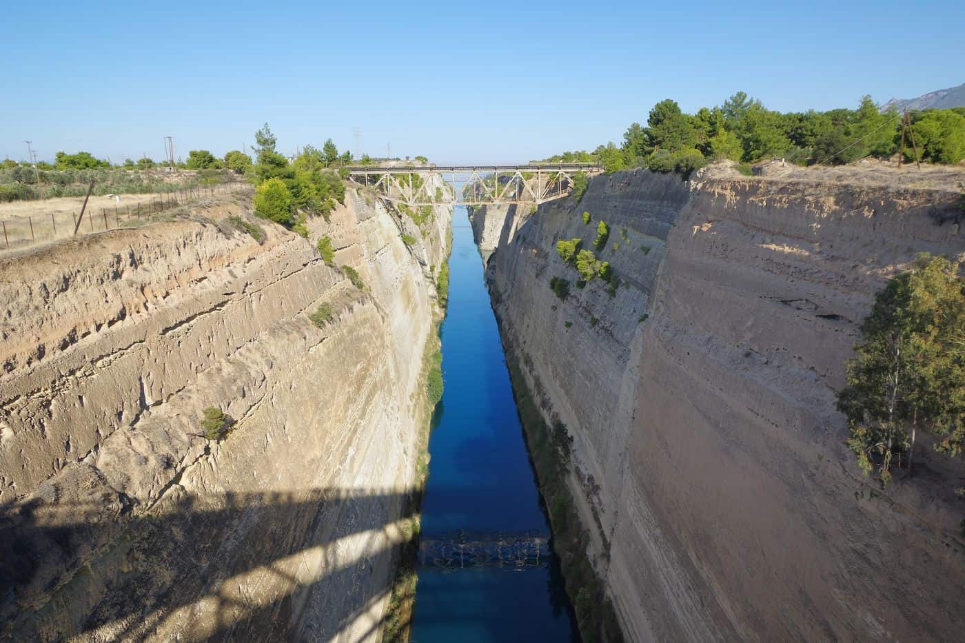
Corinth Canal tours visit the ship canal cut through the Isthmus of Corinth, the strip of land that joins the Peloponnese to mainland Greece and separates the Gulf of Corinth from the Saronic Gulf. The routes cover the boat passages through the canal, the ancient diolkos, the submersible bridges and the views from the bridges. Greece Tours lists the day trips that reach the canal from Athens, Loutraki and Nafplio.
This page covers what Corinth Canal tours see along the cut, how the canal was built, which trips add Ancient Corinth, Acrocorinth, Loutraki and the Heraion of Perachora, how visitors reach the Isthmus, and which season suits each route. The tours below are checked on GetYourGuide and Viator and leave from Athens, Loutraki, Corinth and Nafplio.
What do Corinth Canal tours cover?
Corinth Canal tours cover the cutting through the Isthmus of Corinth that links the Gulf of Corinth with the Saronic Gulf, the view from the bridges about 45 metres above the water, the Hercules relief left by Nero’s workers and the ancient Diolkos ship trackway.
The canal separates the Peloponnese from the Greek mainland and joins the Ionian Sea to the Aegean Sea. It has little economic importance today and is mainly a tourist attraction, so Corinth Canal tours treat the cutting itself as the main sight. A railway line, a road and a motorway cross it.
Corinth Canal tours also cross an ancient border. The Isthmus, 6.3 kilometres wide, was the landmark separating the Peloponnese from mainland Greece, and in the first century AD the geographer Strabo noted a stele here reading “Here is not Peloponnesus, but Ionia” on one side and “Here is Peloponnesus, not Ionia” on the other. Our Corinth Canal day trip from Athens sets out the full plan from the capital.
- The cutting: one channel with no locks, dug at sea level.
- The Hercules relief: on the north side, at the Gulf of Corinth end, below an old bridge foundation.
- The Hexamilion wall: a Roman defensive wall close to the canal, the largest single archaeological structure in Greece.
What history do Corinth Canal tours tell?
Corinth Canal tours tell a story that starts with Periander, tyrant of Corinth in the 7th century BC, runs through the failed dig of Emperor Nero in 67 AD and ends with the modern cutting, formally started in 1882 and completed on 25 July 1893.
Periander, the second tyrant of the Cypselid dynasty, first proposed the cut, then built the Diolkos instead. His change of heart is attributed to the great expense, a lack of labour or the fear of losing Corinth’s role as an entrepôt. Corinth Canal tours then name three rulers who weighed a canal before Nero:
- Demetrius Poliorcetes: dropped his plan after his surveyors miscalculated the sea levels and feared floods.
- Julius Caesar: was assassinated before he began, according to Plutarch and Suetonius.
- Caligula: commissioned a study in 40 AD from Egyptian experts, who wrongly claimed the Corinthian Gulf sat higher than the Saronic Gulf.
Nero broke the ground with a pickaxe. His workforce of 6,000 Judean prisoners of war dug four stades, about 700 metres, before the work stopped at his death, and Corinth Canal tours still trace his line, because the modern canal follows the same course. The idea returned after Greek independence in 1830, when Ioannis Kapodistrias asked a French engineer to assess it, but the cost of 40 million gold francs was far too high for the new state. After the Suez Canal opened in 1869, the government of Thrasyvoulos Zaimis passed a law authorising a Corinth canal.
Corinth Canal tours credit the Société Internationale du Canal Maritime de Corinthe, headed by István Türr, which won a concession in 1881 to build the canal and run it for 99 years. King George I attended the formal start on 23 April 1882. Béla Gerster led the works as chief engineer with four more Hungarian engineers: István Kauser, László Nyári, Garibaldi Pulszky and István Stéghmüller. The company ran out of money after eight years and Türr went bankrupt. In 1890 a Greek company took over, and Greek sources name the company of Andreas Syngros and the engineer Petros Protopapadakis.
What do Corinth Canal tours see at the ancient Diolkos?
Corinth Canal tours see the Diolkos, a paved trackway at the western end of the canal that moved boats overland across the Isthmus from around 600 BC until the middle of the first century AD, sparing them the voyage around the Peloponnese.
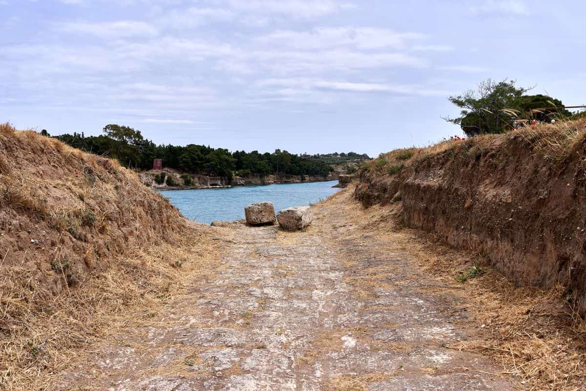
The name joins the Greek dia, “across”, and holkos, “portage machine”. The trackway ran 6 to 8.5 kilometres, crossed the ridge at about 79 metres and ended at Schoinos, today’s Kalamaki, on the Saronic Gulf. Corinth Canal tours view the stretch that the archaeologist Nikolaos Verdelis excavated between 1956 and 1962: a nearly continuous 800 metres, out of 1,100 metres traced in all. Ship movements in the canal have eroded this western end, and restoration work has shored up the bank.
The road was paved with hard limestone, with parallel grooves about 1.60 metres apart, and the tracks show that wheeled vehicles did the carrying. The historian M. J. T. Lewis calls the Diolkos a public railway, open to all on payment. Corinth Canal tours explain the hauling with the figures of the scientist Tolley: a team of 112 to 142 people for a water-soaked trireme, and three hours from sea to sea. Warships crossed the Isthmus too:
- The Spartans: planned in 428 BC to haul warships over the Diolkos to threaten Athens.
- Demetrius of Pharos: had about fifty vessels dragged across to the Bay of Corinth in 220 BC.
- Octavian: had part of his 260 Liburnians carried over after his victory at Actium in 31 BC.
How big is the canal that Corinth Canal tours visit?
Corinth Canal tours visit a channel 6,343 metres long, 24.6 metres wide at the surface, 21.3 metres wide at the bottom and 8 metres deep, cut between rock walls that rise 90 metres above sea level at a near-vertical 80° angle.
Greek sources give a depth of 7.50 to 8 metres. The cutting saves ships a 700-kilometre journey around the Peloponnese, but Corinth Canal tours show why big ships stay away: the canal is too narrow and shallow for large oceangoing vessels and takes a maximum draft of 7.3 metres. Greek sources set the maximum passage width at about 22.5 metres, which fits only handysize ships.
Traffic moves one convoy at a time on a one-way system, and tugs tow the larger ships. The high walls funnel wind along the channel, and the different tide times in the two gulfs cause strong tidal currents. Corinth Canal tours also point to the walls, cut through heavily faulted rock in an active seismic zone; in 1923 alone 41,000 cubic metres of material fell into the channel, which took two years to clear.
- Record ship: the 900-passenger cruise ship Braemar, 195 metres long and 22.5 metres wide, in October 2019.
- Annual traffic: around 15,000 ships, mainly tourist ships.
- Retaining walls: 165,000 cubic metres of masonry along more than half the length.
Which Corinth Canal tours sail through the canal?
Corinth Canal tours that sail through the canal travel on passenger ships, yachts, sailing boats and cruise ships, since the narrow channel now serves mainly tourist ships and smaller recreational boats. One passage between Isthmia and Poseidonia takes about 40 minutes.
Corinth Canal tours follow a one-way system, with one convoy passing at a time. Towing is compulsory for ships of 800 net tons and above, and a canal pilot guides every towed ship, plus every ship over 100 net tons at night. Passenger ships and warships get priority when they arrive within half an hour of other vessels.
Big cruise ships are the exception on Corinth Canal tours. On 9 October 2019 the MS Braemar, 22.5 metres wide and 195 metres long, became the widest and longest ship to transit the canal. Yachts, megayachts and sailing boats have used the passage for more than 130 years.
Passengers on Corinth Canal tours pass under a railway line, a road and a motorway, and these bridges cap the safe height for navigation at 52 metres. At the Gulf of Corinth end, a relief of Hercules left by Nero’s workers sits on the north wall, below an old bridge foundation.
- Currents: the flow turns every six hours and runs at 2.5 knots.
- Night lights: amber sodium lamps set every 100 metres light the rock slopes.
- Entrances: a green harbour light on the right and a red one on the left guide ships in.
What do Corinth Canal tours see at the submersible bridges?
Corinth Canal tours see a road bridge sink into the sea. Two submersible bridges, one at Isthmia on the Saronic Gulf and one at Poseidonia on the Gulf of Corinth, lower their centre span to 8 metres below the water so boats sail over it.
The bridges that Corinth Canal tours watch went in at sea level in 1988, by the eastern harbour of Isthmia and the western harbour of Poseidonia, and gave road traffic two extra crossings. With no structure above the channel, sailing boats pass with no height limit, while the sunken deck limits the draft of passing vessels.
The Isthmia bridge at the south-east end has the best facilities for watching the deck sink, from one of the terraces. The canal company, based at Isthmia, posts operation updates for both bridges, and a look at them before Corinth Canal tours set out pays off, because repairs take a bridge out of service; the company once moved the Isthmia bridge by floating crane to Salamina for restoration.
Isthmia village, 7.5 km south-east of Corinth at the south entry of the canal, also keeps the ancient sanctuary of Poseidon, with the Temple of Poseidon, the ancient stadium, the ancient theatre and an archaeological museum. The Isthmian Games began there in 582 BC and ranked second only to the games at Olympia.
- High crossings: two road bridges and two railway bridges also span the canal.
- Emergency link: a military emergency bridge stands at the west end.
- Cameras: five cameras along the canal and at the Poseidonia entrance watch shipping.
Which Corinth Canal tours add Ancient Corinth and Acrocorinth?
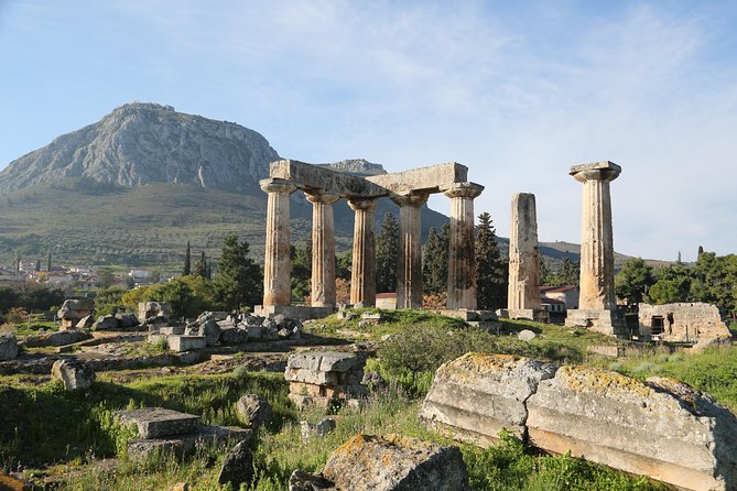
Corinth Canal tours that add Ancient Corinth continue to the ruins below Acrocorinth: the Temple of Apollo, the Peirene fountain, the Bema of Saint Paul and the site museum, then climb the 575-metre rock of Acrocorinth to its three rings of walls.
The Ancient Corinth site and its Archaeological Museum lie within 20 minutes of Loutraki, which keeps the pairing short for Corinth Canal tours. The Temple of Apollo, built in the 6th century BC, is one of the earliest Doric temples in Greece, and seven of its columns still stand. Poets travelled to the Peirene fountain to drink and find inspiration.
Corinth Canal tours on the trail of Saint Paul stop at the Bema, later turned into the Church of Apostle Paul. Paul first reached Corinth in AD 49 or 50, lived there for eighteen months, and faced a trial before Gallio, brother of Seneca, in AD 51/52.
Above the ruins, Acrocorinth commanded the Isthmus of Corinth and blocked entry by land into the Peloponnese. A single uphill road on the west side climbs through gates on three levels to the upper castle, where a temple of Aphrodite became a church and then a mosque. In a myth that links the stops of Corinth Canal tours, Briareus ruled that the Isthmus belonged to Poseidon and Acrocorinth to Helios.
- Roman Odeion: built in the 1st century AD and turned into an arena in the 3rd century AD.
- Upper Peirene: a spring inside the walls of Acrocorinth, known today as the Dragonera cistern.
- Venetian walls: the Venetians took the castle in 1687 and gave it its present form.

Which Corinth Canal tours continue to Loutraki and the Heraion of Perachora?
Corinth Canal tours that continue north reach Loutraki, a spa town on the Gulf of Corinth 4 km from the canal, then follow the Perachora peninsula past Lake Vouliagmeni to the Heraion, a sanctuary of Hera in a small cove at the tip.
For Corinth Canal tours, Loutraki is the mainland stop: the town lies northwest of the canal, so it is not on the Peloponnese. Its 3.5 km beach runs from the canal to the seaside park. The ancient town here was Thermae, named for its hot springs, and Loutraki tours show a town recognised as a spa resort since 1925.
Corinth Canal tours that take the peninsula road pass Perachora, 7 km northwest of Loutraki. Lake Vouliagmeni, a lagoon 6 km west of the village, is 2 km long and no deeper than 40 metres, and a channel no wider than 6 metres joins it to the Gulf of Corinth. The film The 300 Spartans was shot around the lagoon in 1962.
The Heraion of Perachora was founded in the late 9th century BC, and cult activity lasted until 146 BC, when the Roman general Mummius sacked Corinth. Its 6th-century BC Doric temple of Hera Akraia had a cella split into three aisles, and its two-storey L-shaped stoa is the first known example of Doric columns below and Ionic above.
- Melagavi lighthouse: the Heraion lighthouse on Cape Melagavi, first lit in 1897, guides ships in the Gulf of Corinth toward the canal.
- Seaside park: built on land claimed from the sea with rubble from houses felled by the 1928 earthquake.
- Old lake names: in antiquity the lagoon was called Eschatiotis and Gorgopis.
How do visitors reach the canal on Corinth Canal tours?
Corinth Canal tours reach the cutting by road, rail or intercity bus from Athens. Corinth lies about 78 kilometres west of Athens, the canal runs about 4 kilometres east of the city, and the A8 Olympia Odos toll motorway links Athens with Corinth.
Self-drive Corinth Canal tours follow the A8, which spans 290 kilometres from Athens to Patras and Pyrgos via Corinth, with 3 lanes per direction between Eleusis and Corinth. At Corinth the A7 toll motorway branches off towards Tripoli and Kalamata, and the city is the main entry point to the Peloponnese, so the canal stop leads straight into longer Peloponnese tours.
Rail-based Corinth Canal tours ride Line A4 of the Athens Suburban Railway, which runs between Piraeus and Kiato with up to one train per hour, and the journey from Athens to Corinth takes about 55 minutes. Corinth railway station opened on 27 September 2005, 2.9 kilometres from the town centre near Examilia, and copies of ancient artefacts excavated during its construction are on display in the subway to the platforms.
Bus-based Corinth Canal tours use KTEL Korinthias, which runs intercity buses to Athens via the Isthmos station southeast of the city centre; KTEL is a cooperation of 62 regional bus companies. Travellers on the old road cross the cutting on the road bridge, whose reconstruction the Army Engineering School took on in 1947.
- Toll stations: the A8 has toll stations at Eleusis, the Isthmus, Zevgolateio, Elaionas and Rio.
- Service areas: the A8 has service areas at Nea Peramos, Megara, the Isthmus, Kiato, Akrata and Aigio.
- Old road: National Road 8, the old Athens-Patras national road, runs through the Isthmus of Corinth.
- Station forecourt: Corinth station has a local bus stop, a large free car park and a taxi rank.
When do Corinth Canal tours run best?
Corinth Canal tours run best in the dry season of a hot-summer Mediterranean climate with cool, rainy winters. July is the hottest month, averaging 28.7 °C, January the coldest at 9.1 °C, and Corinth receives about 463 millimetres of rain per year.
The climate figures behind Corinth Canal tours come from the nearby Velo weather station, operated by the Hellenic National Meteorological Service, which records an average annual temperature of 18.1 °C. Before a trip, the website of the Corinth Canal company carries a live traffic page and a weather forecast page.
Closures also shape Corinth Canal tours. The limestone walls sit in an active seismic zone and have been unstable from the start, and the wake of passing ships undermined them, so builders added retaining walls along the water’s edge for more than half of the canal’s length, using 165,000 cubic metres of masonry.
- 1893 to 1940: the canal closed for a total of four years of maintenance to stabilise the walls.
- 1923: 41,000 cubic metres of material fell into the canal and took two years to clear.
- 2018: closures hit the canal in February and November.
- 2021: a landslide closed the canal on 15 January.
- 2022: the canal opened for the tourist season until October, closed again for further restoration work and later reopened after further safety measures.
Which activities do Corinth Canal tours add above the canal?
Corinth Canal tours add bridge viewpoints, bungee jumping and the sanctuary of Poseidon at Isthmia. A railway line, a road and a motorway cross the cutting at a height of about 45 metres, and the sanctuary hosted the Isthmian Games in honour of Poseidon.
The high crossings give Corinth Canal tours their viewpoints down the cutting. Two road bridges and two railway bridges span the canal, and a military emergency bridge stands at its west end.
Bungee jumping from the bridge turns the cutting into an adventure stop on Corinth Canal tours. An American reality race show sent one contestant on a 73-metre bungee jump into the Corinth Canal, and a later season revisited the same jump. Because an ankle-only tie can come loose, bungee operators also fit a body harness as a backup safety system.
The sanctuary of Poseidon lies by the village of Isthmia, 7.5 kilometres southeast of Corinth, and Corinth Canal tours pair it with the canal. Oscar Broneer found the site in 1952 and, for the University of Chicago, dug the temple, the theatre, two dining caves and two stadia until 1967. The Early Stadium keeps a starting line for sixteen lanes, and the Roman baths hold the largest monochrome mosaic excavated in the eastern Mediterranean.
- Founding: the Isthmian Games began in 582 BC as one of the Panhellenic Games.
- Schedule: the festival ran in the spring of the second and fourth years of each Olympiad.
- Prize: winners received a wreath of celery, later a pine wreath called the Isthmian pine.
- Contests: the Games held wrestling, boxing, pankration, chariot races and musical contests open to women.
- Rank: the Games at Isthmia were second in significance only to those at Olympia.
Frequently Asked Questions
Do Corinth Canal tours run near the Hexamilion wall?
Yes, the Hexamilion wall stands close to the Corinth Canal and is the largest single archaeological structure in Greece. Built between AD 408 and 450 under Theodosius II, the six-mile wall ran from the Gulf of Corinth to the Saronic Gulf, and under Justinian it gained towers to a total of 153.
Which ancient boundary stone do Corinth Canal tours recall?
The geographer Strabo noted a stele on the Isthmus of Corinth in the first century AD. One inscription, facing east towards Megara, read “Here is not Peloponnesus, but Ionia”, and the other, facing west, read “Here is Peloponnesus, not Ionia”. Plutarch credited the stele to the Attic hero Theseus on his way to Athens.
Can travellers preview Corinth Canal tours online?
Yes. The website of the Corinth Canal company offers a 360 virtual tour of the waterway, and a separate virtual tour covers the sanctuary of Isthmia and its monuments. The company keeps its administrative services at Isthmia in Corinthia, and its naval service fleet includes vessels named Vergina, Stefanos Tyrr, Triton and Andreas Syngros.
Which village grew up at the south entry on Corinth Canal tours?
Isthmia, at the south entry of the canal, was a small village until the canal was dug between 1880 and 1893, after which it developed into a community. It now includes the settlements of Kyras Vrysi, Kalamaki, Paradeisos, Agios Charalampos and Kavos, belongs to the Loutraki-Perachora-Agioi Theodoroi municipality, and keeps an archaeological museum.