
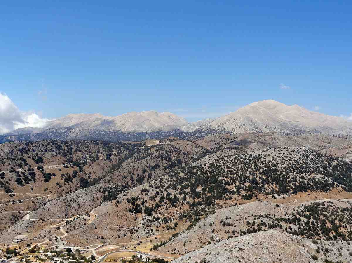
The White Mountains dominate western Crete as a vast limestone massif rising to over two thousand four hundred metres at Pachnes summit. Pale rock gives Lefka Ori its name, gleaming under the Mediterranean sun and holding snow patches into early summer. Deep gorges slice through the range toward the Libyan Sea, while the high Omalos plateau opens among the peaks. The core of the range forms a protected national park sheltering rare flora and wild mountain goats. Discover this dramatic alpine landscape with My Greece Tours.
More than fifty summits exceed two thousand metres across this rugged wilderness in the Chania region. Shepherds’ stone mitata stand on remote slopes, and griffon vultures circle the crags. The European E4 path traverses the range from late spring through autumn once winter snows retreat. The sections below cover the geology and naming of the range, the famous gorges cutting through the massif, wildlife and botanical treasures, traditional mountain culture, and practical guidance for walkers. Our Crete travel guide offers further resources for planning your mountain adventure.
Why are the White Mountains of Crete called Lefka Ori?
Pale limestone gives the White Mountains their Greek name Lefka Ori, meaning white mountains. The rock glares brilliant white under intense summer sun and holds snow patches into early summer, creating a striking pale appearance visible across western Crete.
The geology of the range consists almost entirely of limestone formed from ancient seabeds, creating the characteristic pale grey and white coloration that defines the massif. This carbonate rock weathers to a chalky surface that reflects sunlight with exceptional intensity during summer months. Snow accumulates in sheltered hollows and north-facing slopes through winter, persisting in high cirques and gullies well into June in typical years. The combination of pale stone and lingering snowfields creates the brilliant white appearance that gave the range its enduring name. Sailors approaching the southern coast of Crete from the Libyan Sea have used these gleaming peaks as navigation landmarks for millennia.
The limestone also shapes the hydrology of the range, with water disappearing into underground channels and emerging as springs at lower elevations rather than forming surface streams across the high plateaus.
Pachnes stands as the highest point at approximately two thousand four hundred and fifty metres, though the entire massif contains more than fifty peaks exceeding two thousand metres elevation. The range fills most of the Chania prefecture in western Crete, extending roughly forty kilometres from east to west and twenty-five kilometres north to south. Steep escarpments drop toward the Libyan Sea on the southern flank, while gentler northern slopes descend toward coastal plains. The Omalos plateau sits at roughly one thousand metres elevation, forming a high basin surrounded by peaks and serving as the traditional gateway to the interior.
Visitors exploring Chania can see the white summits rising inland, particularly striking in spring when snow cover remains extensive and the contrast with coastal greenery reaches its peak throughout the season.
Which gorges cut through the White Mountains in Crete?
Four major gorges drain the White Mountains toward the Libyan Sea: Samaria, Imbros, Aradena and Agia Irini. Each canyon cuts dramatically through the limestone massif, creating spectacular walking routes from the high plateaus down to the southern coast and isolated coastal villages.
The Samaria Gorge stretches sixteen kilometres from the Omalos plateau to the coastal settlement of Agia Roumeli, making it the longest gorge in Crete and one of the longest in Europe. The canyon narrows to just three metres width at the famous Iron Gates section, where vertical walls soar hundreds of metres overhead. The gorge forms part of the national park protecting the White Mountains core, and walkers descend roughly one thousand two hundred metres through pine forests, abandoned settlements and dramatic rock formations. The route typically requires five to seven hours to complete, with the path open from late spring through mid-autumn depending on water levels and weather conditions.
Thousands of visitors walk Samaria each summer, making it the most popular of the White Mountains gorges and one of the premier things to do in Crete for active travellers.
The Imbros Gorge offers a shorter alternative at roughly eight kilometres, descending from Imbros village to the coastal town of Hora Sfakion with less dramatic elevation change than Samaria. Aradena Gorge features a spectacular bridge spanning the chasm near its head, with a technical route down to Marmara beach requiring scrambling skills and experience. Agia Irini Gorge provides another moderate walk of roughly seven kilometres, less crowded than Samaria but still offering impressive canyon scenery and ending near the coastal village of Sougia. Each gorge reveals different aspects of the limestone geology, with water-carved channels, caves, and seasonal waterfalls.
The southern coastal region of Sfakia serves as the exit point for most gorge walks, with boats connecting the isolated coastal settlements accessible only by sea or mountain paths.
What wildlife lives in the White Mountains of Crete?
Wild goats known as kri-kri inhabit the White Mountains, along with griffon vultures soaring above the peaks. Rare alpine plants grow in high-elevation habitats. The national park protects these species and their mountain ecosystems across the core of the range.
The Cretan wild goat or kri-kri represents the most iconic mammal of the White Mountains, with protected populations living within the national park boundaries and particularly concentrated in the Samaria Gorge area. These agile animals navigate steep cliffs and rocky terrain with remarkable skill, feeding on mountain vegetation and sheltering in caves and overhangs. Griffon vultures maintain nesting colonies on remote crags, using thermal currents rising from sun-heated limestone to soar across the range in search of carrion. Golden eagles also hunt across the high peaks, though in smaller numbers than the vultures.
Smaller mammals include badgers, martens and weasels in forested zones at middle elevations, while the high plateaus support populations of mice and shrews adapted to harsh alpine conditions with cold winters and limited vegetation cover throughout the year.
The botanical diversity of the range includes endemic species found nowhere else on earth, with plants adapted to limestone soils, intense summer drought, and winter snow cover. Alpine zones above two thousand metres support cushion plants, rock-dwelling species and specialized herbs that flower briefly during late spring and early summer. Lower slopes feature Cretan endemic maples, wild pear trees and aromatic herbs including oregano, thyme and sage. The national park designation protects roughly fifty square kilometres of the core massif, restricting development and grazing to preserve wildlife habitats. Shepherds continue traditional practices in designated zones outside the strictest protection areas, maintaining stone mitata as seasonal shelters during summer grazing periods.
Visitors interested in hiking in Crete find the White Mountains offer exceptional opportunities to observe Mediterranean mountain ecology across elevation gradients from coastal maquis to true alpine environments above the tree line.
What is traditional mountain culture in the White Mountains?
Shepherds built stone mitata as seasonal shelters across the high slopes, using these circular huts during summer grazing. Transhumance patterns moved flocks between coastal winter pastures and mountain summer grazing, creating a pastoral culture adapted to the rugged terrain and seasonal rhythms.
The mitato represents the characteristic mountain architecture of the White Mountains, constructed from dry-stone limestone without mortar in circular or oval plans typically three to five metres in diameter. Corbelled roofs create weatherproof interiors where shepherds sheltered during summer months while tending flocks on high pastures. These structures dot the landscape across the range, concentrated particularly around the Omalos plateau and other accessible high grazing areas. Shepherds produced cheese from sheep and goat milk in the mitata, developing local varieties that remain prized in Cretan cuisine today. The pastoral economy shaped settlement patterns across western Crete for centuries, with mountain villages serving as bases for families whose livelihoods depended on seasonal movement of livestock.
Stone-paved kalderimi trails connected coastal settlements with mountain pastures, engineered to allow loaded pack animals to navigate steep terrain safely throughout the grazing season.
Resistance fighters used the White Mountains as refuge during periods of conflict, with the rugged terrain and limited access providing natural defensive advantages, and the village of Therisso served as a base for the revolt of the early twentieth century. The mountains sheltered partisans during the mid-twentieth century occupation, with local shepherds providing crucial knowledge of routes and hiding places. This history adds cultural significance to the physical landscape, commemorated in place names and local memory. Modern economic changes have reduced traditional shepherding, though pastoral practices continue in modified forms with smaller flocks and motorized access to some areas. The European E4 long-distance path crosses the White Mountains, following traditional routes and kalderimi sections where these remain intact.
The trail typically opens from late spring through autumn once snow clears from high passes, offering multi-day trekking opportunities through remote terrain. Walkers experience the landscape much as shepherds did, though modern equipment and marked routes reduce the challenges that once made mountain travel the domain of specialists with intimate local knowledge.
When is the best time to visit the White Mountains in Crete?
Late spring through autumn offers the best conditions for visiting the White Mountains, typically from May through October. Snow clears from high routes by late spring, while summer heat makes coastal areas less comfortable but mountain elevations remain pleasant with cooler temperatures.
Winter conditions bring snow accumulation across the range above one thousand metres elevation, closing high routes and making the peaks accessible only to experienced mountaineers with winter equipment. The Omalos plateau typically receives substantial snowfall, with the access road sometimes closed during storms. Snow persists in sheltered locations and north-facing slopes into early summer, particularly above two thousand metres where patches may last into June in years with heavy winter precipitation. Late spring marks the transition period when lower gorges open for walking while high peaks still carry snow, creating dramatic scenery with white summits rising above green valleys. Wildflowers bloom across alpine zones during this period, making late May and June particularly rewarding for botanically-minded visitors.
Summer brings stable weather with minimal rainfall, though temperatures on exposed slopes can become uncomfortably hot during midday hours in July and August despite the elevation.
Autumn offers excellent conditions from September through October, with summer heat moderating but weather generally remaining settled and reliable. The gorges stay open through mid-autumn, typically closing in November depending on rainfall and the onset of winter storms. Spring and autumn provide the most comfortable temperatures for strenuous walking, with midday heat less intense than summer months. Water sources become scarce during late summer across high elevations, making spring preferable for extended treks when snowmelt keeps springs flowing. Gorge walks operate on seasonal schedules, with Samaria typically open from early May through mid-October depending on conditions in any particular year. Visitors should verify current access before planning trips, as opening and closing dates vary with weather patterns.
The shoulder seasons of late spring and early autumn combine good weather, moderate temperatures, fewer crowds than peak summer, and accessible routes, making these periods ideal for exploring the White Mountains and experiencing the full range of landscapes from coastal zones to alpine peaks.
Frequently Asked Questions
How difficult is hiking in the White Mountains?
The difficulty varies considerably depending on chosen routes and objectives. Gorge walks like Samaria and Imbros require reasonable fitness for sustained downhill walking on rocky paths but involve no technical climbing or scrambling on the main routes. The Samaria descent covers sixteen kilometres with roughly one thousand two hundred metres elevation loss, typically taking five to seven hours at a steady pace. Imbros offers a shorter, less strenuous alternative suitable for most walkers with basic fitness. High mountain routes following the E4 path or reaching major summits demand greater experience, navigation skills and fitness, with remote terrain, limited water sources and potential for rapidly changing weather.
Summit ascents often involve long approaches across rocky terrain without marked paths, requiring map reading ability and mountain experience. Walkers should carry adequate water, sun protection, sturdy footwear and layers for changing conditions. Guided trips provide safer options for those lacking mountain experience, while independent walkers should research routes thoroughly and inform others of plans before setting out into remote areas of the range.
Can you drive into the White Mountains?
Paved roads reach the Omalos plateau at roughly one thousand metres elevation, providing vehicle access to the starting point for Samaria Gorge and accommodation options in the high basin. The road from Chania climbs through mountain villages with spectacular views, taking approximately one hour to reach Omalos. Other gorges have road access to their starting points, with paved routes reaching Imbros village and the Aradena bridge. Dirt tracks penetrate further into the range in certain areas, accessible to four-wheel-drive vehicles and used primarily by shepherds and forestry personnel. These rough tracks reach some mitata zones and high grazing areas but require appropriate vehicles and local knowledge.
The vast majority of the White Mountains remains roadless wilderness accessible only on foot, preserving the remote character that defines the range. Coastal settlements at gorge exits like Agia Roumeli and Loutro lack road connections entirely, accessible only by boat or hiking trails. This combination of limited road access and extensive roadless terrain creates the distinctive character of the White Mountains, where genuine wilderness exists within relatively short distances of developed coastal areas and the regional capital.
What should I bring for a day hike in the White Mountains?
Water represents the most critical item, with at least two litres per person recommended for gorge walks and more for high mountain routes where sources are scarce. The limestone terrain and intense sun create high water requirements even at elevation. Sturdy hiking boots with ankle support and good tread provide essential footwear for rocky, uneven paths with loose stones and sustained descents. Sun protection including hat, sunglasses and high-factor sunscreen prevents burns from intense Mediterranean sun reflected off pale limestone. Layers allow adjustment to changing conditions, with temperatures varying significantly between shaded canyon floors and exposed slopes. A light waterproof jacket guards against unexpected rain, though summer storms are infrequent.
Snacks and lunch provide energy for sustained walking, with no facilities available once routes begin. A basic first aid kit, mobile phone, map and compass add safety margins, though phone coverage remains unreliable in deep gorges and remote areas. Trekking poles help on steep descents, reducing impact on knees during long downhill sections. Swimwear allows cooling off in pools along some gorge routes during warmer months when water flows.