
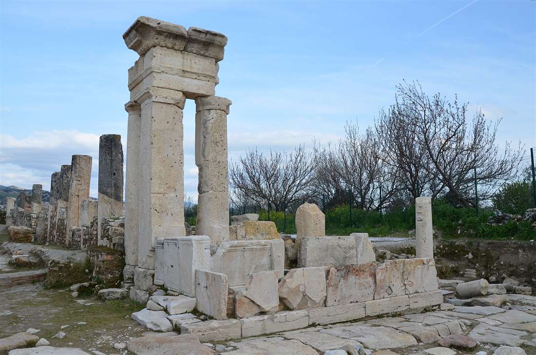
Tripolis on the Meander is a Greco-Roman city on the Buyuk Menderes river near Buldan, about 40 kilometres from Pamukkale and Denizli, a quiet rising archaeological site whose restored colonnaded street, theatre and gate rival those of nearby Hierapolis. Plan the whole trip with Greece Tours.
This guide covers Tripolis on the Meander in full: what the city is and where it lies, its history on the border of Lydia, Caria and Phrygia, the restored colonnaded main street, the theatre, the city gate and walls, the baths and the villa, the recent excavations, what survives today, and how to visit it with Pamukkale and Laodicea.
What is Tripolis on the Meander?
Tripolis on the Meander is an ancient Greco-Roman city on the Buyuk Menderes river near Buldan in Denizli province, western Turkey. It ranks among the Lycus valley’s rising archaeological sites, where recent excavations expose a colonnaded street, a theatre, a monumental gate and a bathhouse.
The city took its Greek name, Tripolis ad Maeandrum, from its position on the Maeander river, the ancient name of the Buyuk Menderes. It sits on a broad terrace above the valley floor, on the historic frontier where the territories of Lydia, Caria and Phrygia met. Ancient writers list it under different names, including Apollonia and Antoniopolis, evidence of the political shifts that renamed the settlement across the Hellenistic and Roman centuries.
Tripolis belongs to the same fertile corridor as Pamukkale and Laodicea, a valley threaded by hot springs, marble outcrops and trade routes. The site remained buried under farmland for a long stretch, and systematic digging began only in the modern era. That late start explains why Tripolis stays quiet and uncrowded while its neighbours draw large numbers of visitors, and why its restored main street counts as one of the freshest discoveries in the region.
The name itself, Tripolis, means “three cities” in Greek, a label that marks its junction position at the meeting of three ancient lands rather than a union of three towns. The terrace it occupies covers a wide urban footprint, and geophysical survey and clearance keep enlarging the mapped extent of streets, insulae and public buildings. Archaeologists count the site among the most productive digs in the middle Menderes basin, and its profile rises with each publicised season of finds.
Where is Tripolis and how far from Pamukkale?
Tripolis lies beside the village of Yenicekent, close to the town of Buldan, on the north bank of the Buyuk Menderes river. It stands about forty kilometres north-west of Denizli city and roughly forty kilometres from Pamukkale, an easy half-day trip from either base.
The site occupies the Lycus valley’s western edge, where the Menderes cuts a wide green plain between the Buldan hills and the Babadag massif. Yenicekent sits directly at the foot of the ruins, and the modern road threads past cotton fields and vineyards that still work the same alluvial soil the ancient farmers tilled. The elevation gives the terrace a clear view down the river toward the confluence with the Lycus.
The drive from Pamukkale runs west along the valley highway and reaches the turn-off for Yenicekent in under an hour. From central Denizli the route heads north-west through Saraykoy before crossing to the river’s north bank. The proximity puts Tripolis within a single itinerary that also takes in Buldan’s weaving workshops and the travertine terraces, so travellers pair the three without a long transfer.
Denizli anchors the wider region as its transport hub, with an airport at Cardak and a railway station that links the valley to Izmir and the Aegean coast. From that base the ancient sites of the Lycus and Menderes valleys spread within an hour’s drive in each direction, and Tripolis marks the north-western point of that cluster. The village setting keeps the approach rural: the road narrows past orchards and the river runs close on the southern side before the terrace of ruins comes into view.
What is the history of Tripolis?
Tripolis grew from a Hellenistic foundation on the border of Lydia, Caria and Phrygia, flourished as a Roman provincial town on the Menderes trade route, and continued as a Byzantine bishopric. Repeated earthquakes across its long life forced constant rebuilding until the medieval settlement contracted.
The settlement rose in the Hellenistic period on a strategic terrace that controlled river crossings and the road between the Aegean coast and the Anatolian interior. Under Roman rule it minted its own coins, joined the provincial network of the Asian assize districts, and prospered from the textile and agricultural wealth of the valley. Its citizens raised public monuments in marble quarried from the surrounding ranges, and the street grid took the ordered colonnaded form typical of a Roman city of the second and third centuries AD.
Tripolis converted to Christianity in the Byzantine era and appears in church records as the seat of a bishop, a status that placed it in the same ecclesiastical world as Laodicea further down the valley. Earthquakes, endemic to this seismic corridor, struck the city more than once and levelled parts of the public centre. The population rebuilt on the ruins, raised late defensive walls from reused blocks, and gradually withdrew to a smaller fortified core before the classical city faded entirely under agricultural land.
The city’s wealth rested on its command of the river route and on the wool and cloth production that defined the whole valley economy. Coins struck at Tripolis carry the images and titles of successive emperors, fixing the town firmly within the imperial administration of the province of Asia. The frontier position that gave the city its name also placed it at a cultural crossroads, where Lydian, Carian and Phrygian traditions blended into the Greek and then Roman civic order that shaped its monuments.
In the medieval centuries the contracting town clustered behind its late walls, and the great public buildings passed into ruin as their marble was quarried for defence and reuse. The Ottoman village of Yenicekent eventually rose beside the ancient terrace, and local memory preserved the ruins as a source of building stone long before archaeologists identified and protected the site. The layers of that long occupation, Hellenistic, Roman, Byzantine and later, all register in the excavated ground.
What is the colonnaded street of Tripolis?
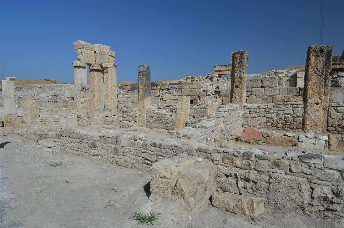
The colonnaded street is the restored main avenue of Roman Tripolis, a broad paved thoroughfare lined with re-erected marble columns and the fronts of shops that opened onto it. Recent excavations lifted the fallen shafts back into place, making the street the centrepiece of the open site.
The avenue ran through the heart of the city on a north-south axis, flanked by covered porticoes that sheltered pedestrians from sun and rain. Behind the colonnades stood rows of small commercial units, each a single room fronting the walkway, where merchants sold cloth, food and pottery. The paving slabs still carry the ruts and worn surfaces left by centuries of cart wheels and foot traffic, and the drainage channels beneath the stones remain traceable along the route.
Restoration work re-erected a long run of columns using the original marble drums recovered where they collapsed, so the street now presents an unbroken line of standing shafts against the valley backdrop. The reconstruction follows the same principle applied at other Menderes-valley sites, anastylosis, which returns fallen members to their exact positions. The result gives visitors a direct sense of the avenue’s original scale and rhythm, a rare experience at a site so lightly visited.
The shops behind the colonnade formed a continuous commercial frontage, the ancient equivalent of a covered arcade, and excavation of their floors turns up the stock and tools of the traders who worked them. Marble kerbs separate the raised walkway from the roadway, and the column bases sit on a stylobate that runs true along the length of the excavated stretch. The street ties the theatre, the gate and the bath quarter into a single planned axis, the spine along which the Roman city was laid out.
What is the theatre of Tripolis?
The theatre of Tripolis is a Roman-period auditorium cut into the natural slope of the terrace on the city’s northern edge. Its curved seating banks face the valley, and excavation has cleared the cavea, the orchestra and the foundations of the stage building.
The builders exploited the hillside to support the semicircular tiers of seats, the standard Greco-Roman method that saved on masonry substructure. Spectators climbed the ranked stone benches to watch performances and civic assemblies staged on the level orchestra below. The seating fans out in the classic horseshoe, divided by radiating stairways that channelled the audience to their rows, and the upper limit of the cavea gives a commanding outlook over the Menderes plain.
The stage building, the scaenae frons, once rose as a decorated marble facade at the foot of the seating, though earthquakes toppled much of its architecture. Fragments of columns, cornices and carved blocks lie in the excavation zone, and the recovered pieces record the ornamented backdrop that framed the acting area. The theatre anchored the public life of Tripolis alongside the colonnaded street, and its clearance forms a central part of the ongoing programme at the site.
A theatre of this scale served a population large enough to fill the ranked banks, evidence of the city’s standing among the towns of the valley. The horizontal walkway, the diazoma, split the seating into upper and lower blocks, and the vaulted entrances, the vomitoria, fed the crowd in and out. Clearance of the orchestra and the stage foundations lets archaeologists trace the phases of construction and repair, and the recovered architectural fragments guide the eventual reconstruction of the facade.
What is the city gate and walls?
The city gate is a monumental entrance that admitted the main road into Tripolis, built as an arched marble structure flanked by towers. It joins a circuit of late defensive walls raised in the Byzantine period from reused earlier blocks to protect the contracted settlement.
The gate stood at the terminus of the approach road, a formal threshold that announced the city to travellers arriving from the valley. Its piers carried an arch of dressed voussoirs, and the flanking masonry framed a passage wide enough for wheeled traffic. Excavation exposed the foundations and lower courses, revealing how the entrance connected to the paved street system that ran on into the urban core.
The later walls trace a defensive line drawn tighter than the classical city’s original extent, a common response across Anatolia as populations concentrated behind fortifications in the Byzantine centuries. The builders robbed marble from ruined public monuments and set the spolia into rubble-and-mortar curtains, so column drums, inscribed blocks and architectural fragments appear embedded in the fabric. These reused pieces preserve, upside down and out of context, the debris of the earthquakes that ended the monumental phase of Tripolis.
The gate marks the point where the intercity road met the ordered grid, and the alignment of its passage fixes the entry axis of the colonnaded street beyond. Reading the spolia in the late walls turns them into an accidental museum: an inscription honouring a magistrate here, a fluted column drum there, a decorated cornice reset as plain building stone. That reuse, while it destroyed the monuments it stripped, locked their fragments into a durable record that excavation now recovers block by block.
What are the baths and other buildings?
Tripolis holds a large Roman bathhouse, a residential villa paved with mosaics, an early Christian church and the open square of the agora. Together these structures map the public and private life of the city, and excavation continues to clear their walls and floors.
The bathhouse presents the standard sequence of heated and cold rooms served by a hypocaust, the underfloor heating system that raised bathers on brick pillars above furnace-warmed air. Its thick walls, vaulted spaces and water channels stand among the most substantial masonry surviving on the site. Bathing structures like this served as social centres in every Roman town of the valley, and the Tripolis example matches the scale of the civic buildings around it.
The villa, a wealthy private residence, yielded floors laid with figured and geometric mosaics and rooms decorated with painted plaster. The agora, the public square framed by porticoes, functioned as the market and civic assembly ground at the city’s heart. The church, raised in the Byzantine period, marks the Christian phase and its bishopric, and its apse and nave foundations survive within the excavated zone. Each building adds a distinct layer to the picture of a working provincial city.
Water supply underpinned the whole civic centre, delivered through channels and cisterns that fed the baths, the fountains and the street drainage. The bath complex drew on the abundant flow of the valley, the same geological setting that produces the hot springs of the neighbouring travertine plateau. Around these anchor buildings the excavated insulae reveal shops, houses and workshops, so the cleared quarters read as a coherent slice of a city in full operation rather than a scatter of isolated monuments.
What did archaeologists find at Tripolis?
Recent excavations at Tripolis uncovered the restored colonnaded street, wall frescoes and floor mosaics inside a preserved Roman villa, the theatre, the bathhouse and quantities of coins, pottery and sculptural fragments. The finds date the city’s flourish to the Roman imperial centuries and its decline to earthquake destruction.
The villa produced the most vivid material: intact stretches of painted wall plaster in bright pigments, and mosaic pavements set with tesserae in geometric and figural designs. These decorated interiors record the taste and wealth of the city’s leading families and rank among the best-preserved domestic art recovered in the Menderes valley. The excavators lifted and conserved the fragile plaster in place, protecting the frescoes where they fell against the villa walls.
Alongside the architecture the digging recovered coins that fix the city’s active life across the Roman and Byzantine periods, inscribed marble blocks naming benefactors and officials, and broken statuary from the public monuments. The collapse layers themselves tell a story: crushed walls, sheared columns and pinned floors record the seismic events that repeatedly struck the terrace. This evidence links the physical destruction directly to the historical accounts of earthquakes in the valley, and it guides the priorities of the continuing restoration.
The pottery sequence, from fine tablewares to coarse storage jars, dates the layers and traces the trade links that supplied the city from across the Aegean and the interior. Inscriptions carry the language of civic honour, naming those who paid for buildings and games, and they fix the political vocabulary of the town within the imperial system. The conserved frescoes and mosaics move from the trench to protective display, so the discoveries build a public record of the excavation rather than vanishing into store.
What is there to see at Tripolis today?
Visitors to Tripolis today walk an open archaeological site where the standing columns of the restored main street lead the eye across the terrace to the hillside theatre, the monumental gate, the bathhouse walls and the excavated villa. The ruins sit unfenced within the river landscape, free of crowds.
The re-erected colonnade forms the visual anchor: a line of pale marble shafts running the length of the avenue, with the paved surface and shop fronts exposed at their feet. From the street the ground rises to the curved seating of the theatre, and a short walk reaches the gate and the tighter circuit of the late walls. The bathhouse presents the tallest surviving masonry, its vaults and heated rooms legible even in ruin.
The villa area, protected where the frescoes and mosaics came to light, shows the domestic quarter of the city, and the agora foundations mark the civic square. Because Tripolis remains an active dig rather than a packaged monument, sections of the site carry the trenches, tools and shelters of live excavation, which gives the visit the character of archaeology in progress. The valley setting, with the Menderes below and the Buldan hills behind, frames the whole terrace.
A walk of the site follows the line of the main street from the gate through the commercial frontage to the public buildings, a route that reads the ancient city in the order its people knew it. Information boards mark the principal structures, and the open ground rewards a slow circuit rather than a quick pass. The lack of railings and barriers keeps the ruins close and tactile, and the quiet lets the scale of the terrace register without the press of a crowd.
How do you visit Tripolis from Pamukkale or Denizli?
Visitors reach Tripolis by driving west from Pamukkale or north-west from Denizli to the village of Yenicekent, a trip of roughly forty kilometres and under an hour. The site pairs naturally with the travertine terraces of Pamukkale and the weaving town of Buldan in a single day.
From Denizli the route runs through Saraykoy and crosses to the north bank of the Menderes at Yenicekent, where the ruins stand at the village edge. From Pamukkale the road heads west along the valley and joins the same approach. A hired car or a local taxi covers the distance directly, and the entrance to the open site sits at the foot of the excavation terrace, with parking on the village side.
A practical circuit combines Tripolis with the hot springs and white terraces of Pamukkale and, for a fuller archaeological day, the vast ruins of Hierapolis crowning the same travertine plateau. Buldan, minutes uphill from the site, adds its centuries-old textile workshops and shaded old streets. Morning light suits the colonnaded street, and the terrace stays exposed to the sun, so a hat and water make the walk comfortable.
Travellers without a car reach Yenicekent by dolmus, the shared minibus that serves the valley villages from Denizli, then walk the short distance to the site. The open terrace takes a comfortable hour or two on foot, longer for those who read every structure. Pairing the visit with Buldan for lunch and Pamukkale for the afternoon builds a full day that covers craft, archaeology and the natural travertine within a compact loop north-west of Denizli.
How does Tripolis compare with Laodicea and Hierapolis?
Tripolis, Laodicea and Hierapolis all stand within the Lycus and Menderes valleys as Greco-Roman cities of the province of Asia, sharing the colonnaded streets, theatres and bathhouses of the type. Tripolis stays the smallest and quietest of the three, an active dig rather than a mass-visited monument.
Hierapolis crowns the travertine plateau above Pamukkale with a huge theatre, a monumental necropolis and the sacred pool, and it draws large crowds as the headline site of the region. Laodicea, on the plateau between the two rivers, spreads across an even wider urban grid with twin theatres, stadiums and the church that names it in the scripture of the early faith. Both cities offer scale and fame that Tripolis does not match.
What Tripolis offers instead is intimacy and immediacy: a restored main street walked in near solitude, and an excavation still lifting frescoes and mosaics from the ground. The three sites complement one another within a single archaeological district, and a traveller who links them reads the full story of the valley’s Roman civilisation, from the grand plateau cities to the rising river town at its north-western edge.
What is the Menderes valley setting of Tripolis?
Tripolis stands on a marble terrace above the Buyuk Menderes, the ancient Maeander, where the river winds across a wide alluvial plain between the Buldan hills and the Babadag range. The fertile valley, its hot springs and its marble quarries supplied the city’s food, water and building stone.
The Menderes plain spreads green with cotton, vines and orchards below the terrace, worked on the same soil the ancient farmers tilled. The river’s winding course, the origin of the word “meander”, threads the valley floor toward its confluence with the Lycus and on to the Aegean. The terrace lifts the ruins clear of the flood plain, and the outlook takes in the full sweep of the basin.
The same geological setting that feeds the springs and travertine of the neighbouring plateau gave Tripolis abundant water and a supply of quarried marble from the surrounding ranges. That combination of fertile land, running water and building stone underpinned the city’s rise, and it explains why a substantial Greco-Roman town grew on this frontier terrace in the first place.
What names has Tripolis been known by through history?
Tripolis carried the names Apollonia and Antoniopolis alongside Tripolis ad Maeandrum across its Hellenistic and Roman phases. Each name marks a stage of political patronage, and the enduring form, Tripolis on the Meander, fixes the city by its river and distinguishes it from other towns of the same name.
The label Apollonia honoured the god Apollo, whose cult held a place in the religious life of the region, while Antoniopolis attached the city to imperial favour under a Roman patron. Ancient geographers and church lists preserve these variant names, and the shifts record the way a provincial town courted rulers and gods across the centuries. The final settled name, Tripolis, endured because it pinned the city to its junction of three ancient territories.
The suffix “ad Maeandrum”, on the Meander, separates this Tripolis from settlements of the same name in Lydia, Phoenicia and North Africa. The Maeander river gave the English language the word “meander”, after the winding course the Menderes still traces across its plain below the terrace. That linguistic legacy ties the modern name of the ancient city directly to the landscape a visitor sees from the ruins.
What was daily life like in Roman Tripolis?
Daily life in Roman Tripolis centred on the colonnaded street, the agora, the baths and the theatre, where the townspeople traded cloth and produce, bathed, gathered for assembly and watched performances. The valley’s wool and farmland fed the economy, and the shops behind the porticoes formed the working core of the city.
The people of Tripolis worked the wool of the valley into textiles, a trade shared across the Lycus and Menderes towns and prized throughout the Roman world. Merchants sold their goods from the shop rows along the main street, farmers brought grain, oil and wine from the alluvial fields, and the agora hosted the market and the civic business of the town. Water from the channels fed public fountains that supplied the households and the streets.
Bathing structured the social day, and the hypocaust-heated rooms of the bathhouse drew citizens to wash, exercise and meet. The theatre staged drama and public assembly, and the temples and, later, the church ordered the religious calendar. Inscriptions record the benefactors who funded these buildings and the games held in them, naming the leading families whose wealth and civic pride shaped the monuments that excavation now brings back to light.
Why is Tripolis worth visiting?
Tripolis rewards visitors with quiet, uncrowded ruins, a colonnaded street restored to its standing columns, and the rare chance to watch a major Lycus-valley excavation unfold. It delivers the substance of a Roman city without the crowds that fill its famous neighbours nearby.
The site’s late entry into systematic archaeology means it lacks the visitor infrastructure and the queues of Pamukkale and Hierapolis, and that absence is its appeal. Travellers walk the paved avenue and climb the theatre slope in near solitude, close enough to touch the re-erected marble and the exposed mosaics. The ongoing restoration adds a sense of momentum, since each season lifts more of the buried city into view.
For anyone tracing the archaeology of the Menderes and Lycus valleys, Tripolis completes the picture alongside the springs of Pamukkale, the monuments of Hierapolis and the bishopric of Laodicea. It stands as a working demonstration of how a Greco-Roman city is recovered from the soil, block by block, and its combination of standing ruins, live excavation and river-valley setting makes the short detour from Denizli a genuine reward.
The setting itself justifies the trip: the terrace of marble above the green Menderes plain, the Buldan hills rising behind, and the ancient street pointing down the valley. A visit here trades the scale of the famous sites for the pleasure of ruins that belong, for the moment, to the few who make the detour. As the excavation advances, Tripolis moves steadily from a local secret toward a fixture of the valley’s archaeological circuit.
Frequently Asked Questions
What is Tripolis on the Meander?
Tripolis on the Meander is a Greco-Roman city on the Buyuk Menderes river near Buldan in Denizli province. It holds a restored colonnaded street, a theatre, a monumental gate and baths, one of the rising archaeological sites of the Lycus valley.
How far is Tripolis from Pamukkale?
Tripolis lies near Yenicekent and Buldan, about 40 kilometres north-west of Pamukkale and Denizli, a 45-minute drive. The quiet site pairs with the town of Buldan and the travertines on a day around the valley.
What is there to see at Tripolis?
Tripolis shows a long restored colonnaded street lined with columns and shops, a Roman theatre on the hillside, a monumental city gate, a bathhouse and a villa with mosaics, all set in open uncrowded ruins by the river.