
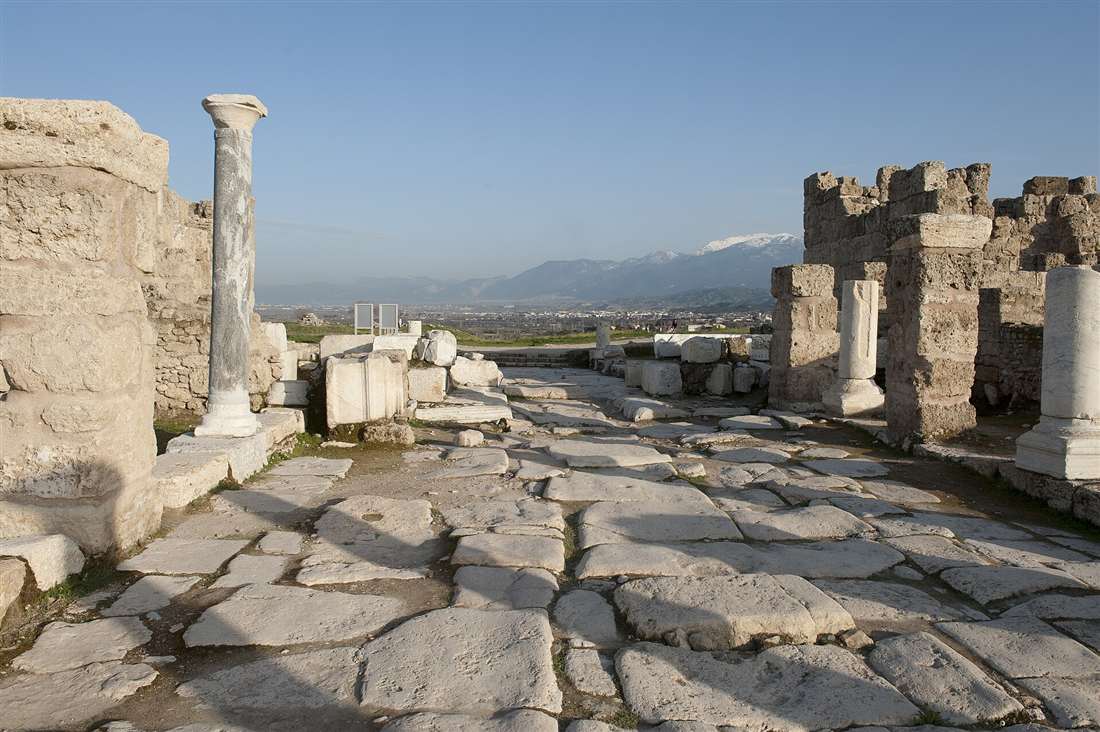
Laodicea on the Lycus is a great Greco-Roman city 10 kilometres from Pamukkale and 6 kilometres from Denizli, one of the best-restored ancient sites in Turkey and one of the Seven Churches of Revelation, famous for the rebuke of its “lukewarm” faith. Plan the whole trip with Greece Tours.
This guide covers Laodicea in full: what the city is and where it stands, why it is one of the Seven Churches of Revelation, the church and baptistery, the wealth of the city, the largest stadium in Anatolia, the two theatres, the colonnaded streets and agoras, the water system that ran lukewarm, the earthquakes, what survives today, and how to visit from Pamukkale and Hierapolis.
What is Laodicea in Turkey?
Laodicea is a large Greco-Roman city on the Lycus river in south-western Turkey, founded in the third century BC by the Seleucid king Antiochus II and named after his wife Laodice. It ranks among the best-restored ancient sites in the country.
The city stands on a broad plateau between two small rivers, the Asopus and the Caprus, tributaries of the Lycus. This position on a natural crossroads turned Laodicea into a hub of trade, banking and manufacturing across the Roman province of Asia. Archaeologists have exposed a monumental core of paved streets, temples, fountains, a bouleuterion, two theatres, a stadium and an early Christian church, all set out on the classical grid that the Hellenistic founders laid down.
Laodicea holds a double importance. For the historian it preserves one of the fullest pictures of a wealthy Anatolian city, with its commercial architecture standing at close to full height along the excavated avenues. For the reader of the New Testament it is the seat of one of the Seven Churches of Revelation, the last of the seven congregations addressed in the book. The site sits within a day-trip radius of Pamukkale and Hierapolis, which turns a visit into a single circuit of the Lycus valley.
The modern name of the district is Laodikeia, and it lies inside the Denizli metropolitan area. Continuous excavation and anastylosis, the careful re-erection of fallen columns and blocks, have raised whole colonnades and gateways from rubble, so the visitor walks a reconstructed streetscape rather than a scatter of foundations. This restoration work marks Laodicea out from most classical ruins in the region.
Where is Laodicea and how far from Pamukkale?
Laodicea lies about six kilometres north of the centre of Denizli in south-western Turkey, and roughly ten kilometres south of Pamukkale and Hierapolis. The three sites sit within the same Lycus valley, a short drive apart on good roads.
The archaeological park occupies a plateau reached by a signed turn-off from the Denizli–Pamukkale road. Denizli airport, Çardak, stands to the east, and the city’s railway and bus stations connect the region to İzmir, Antalya and Konya. From Pamukkale village the transfer to the Laodicea gate takes about fifteen minutes by car, which places the ancient city firmly on the standard Pamukkale itinerary.
Because Laodicea, Hierapolis and the travertine terraces of Pamukkale form a tight triangle, visitors treat them as a linked group. A morning at the white terraces and the ruins of Hierapolis pairs naturally with an afternoon along the colonnaded streets of Laodicea. The distance between any two of the sites is measured in single-digit kilometres, so a hired car, a taxi or a booked tour covers the whole circuit inside one day.
The wider setting matters to the ancient story. Laodicea guarded the point where the road from the Aegean coast at Ephesus met the routes running inland to Phrygia and the east. That geography explains both its riches and its water problem, and it frames every part of the site the traveller walks today.
Why is Laodicea one of the Seven Churches of Revelation?
Laodicea is the seventh and final congregation addressed in the letters of Revelation, chapters two and three. The message rebukes the church for being neither cold nor hot but lukewarm, and turns the city’s own wealth, cloth and eye-salve into images of spiritual poverty.
The letter to Laodicea reads the community through the trades that made the city rich. It charges the church with saying, “I am rich, I have acquired wealth and need nothing,” while being blind, poor and naked in truth. The counsel to buy gold refined in fire, white garments and salve for the eyes draws a direct line to Laodicean banking, the celebrated black wool of the district and the medical school that produced its famous eye ointment. Every rebuke lands on a local industry.
The most quoted image is the lukewarm water. Cold water refreshes and hot water heals, but water that arrives tepid provokes disgust. Laodicea drank water piped over a distance until it reached the taps neither cold from a mountain spring nor hot from a thermal source, a physical fact that the letter turns into a moral warning. Nearby Colossae drank cold spring water and Hierapolis its hot mineral water, which sharpens the contrast the text draws.
This grounding in place ties Laodicea to the biblical geography of western Asia Minor, the same landscape that carried the missions of Paul and the traditions surrounding Ephesus in the Bible. Paul’s letter to the Colossians names the Laodiceans directly and instructs that his letters be read across both congregations, which places the city inside the earliest Christian correspondence.
What is the church of Laodicea?
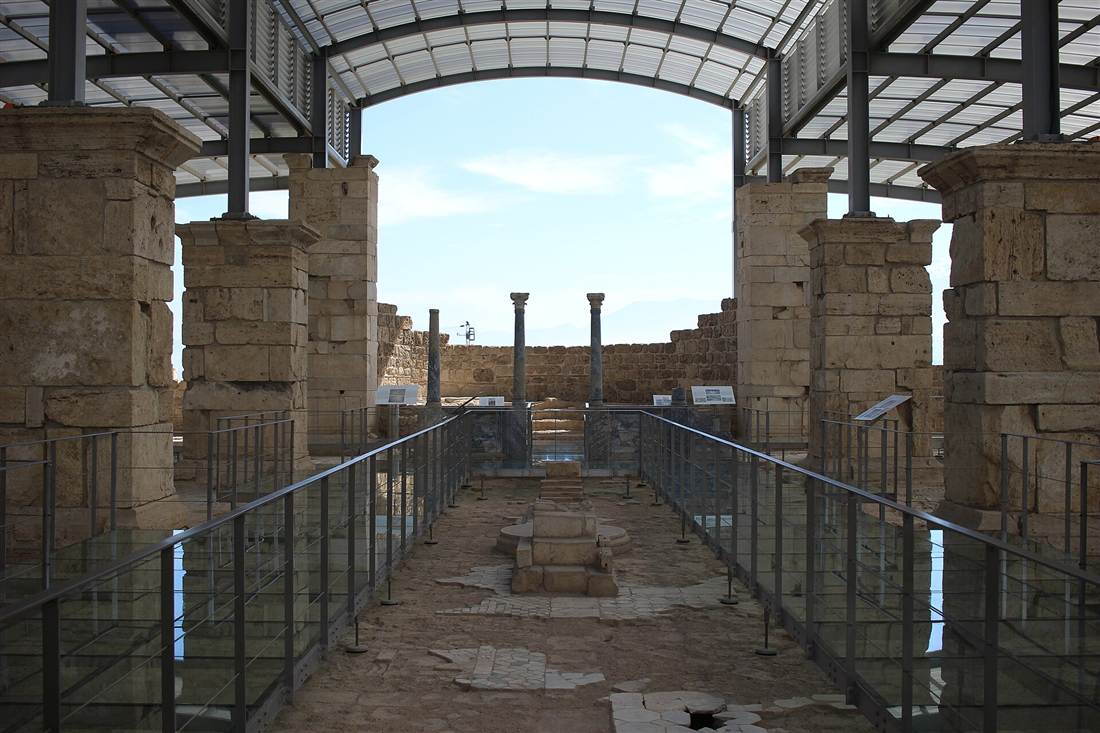
The church of Laodicea is a large early Christian basilica excavated in the north of the site and dated to the fourth century AD. It preserves an apse, a nave and side aisles, a baptistery with a cruciform font, and geometric floor mosaics laid across the whole plan.
The building stands at the point where a Christian congregation replaced the pagan cults of the classical city. Its walls define a three-aisled hall ending in a rounded apse, the standard form of a Roman basilica turned to Christian worship. A protective roof shelters the mosaics, and raised walkways lead the visitor over the ancient floor without treading on the tesserae. The baptistery sits to one side, its font shaped as a cross for full-immersion baptism.
The church gives physical form to the biblical letter. A visitor reads the rebuke in Revelation and then walks the very ground where the named congregation gathered, an unusually direct link between text and place. The excavators uncovered marble screens, column bases and the outline of the clergy bench in the apse, which together reconstruct the liturgical layout of the early Christian centuries.
The discovery of the church reordered the story of the site. It confirms that the community addressed in Revelation grew into an organised congregation with a monumental hall, and it marks Laodicea as a stop for pilgrims tracing the Seven Churches. The building anchors the Christian identity of the ruins alongside the temples, streets and stadium of the Greco-Roman city.
Why was Laodicea a wealthy city?
Laodicea grew rich from its position on a road junction, from the black wool of its sheep, from a banking industry that handled money across the province, and from a medical school that produced a renowned eye-salve. Trade, textiles and finance built the fortune the New Testament names.
The city sat where the highway from Ephesus and the Aegean coast met the roads running east into Phrygia and Pisidia. Goods, travellers and money passed through the plateau, and Laodicean bankers grew prosperous enough to lend across the region. Cicero, governing the neighbouring province, cashed his official drafts at Laodicea, a detail that fixes the city as a financial centre of the Roman east.
Textiles formed the second pillar. The sheep of the Lycus valley grew a soft glossy fleece of a natural black colour, prized for garments and traded far beyond Anatolia. Weavers turned this wool into cloaks and tunics that carried the city’s name to distant markets. The reference in Revelation to buying white garments plays directly against this famous black cloth.
The third pillar rose from medicine. A temple and school associated with the god Men Karou stood near the city, and its physicians developed a Phrygian powder compounded into an ointment for diseases of the eye. This eye-salve travelled the trade routes as a branded product, which is why the letter tells the Laodiceans to anoint their eyes to see. Wealth from all three trades funded the temples, fountains and gates that fill the excavated centre.
What is the stadium of Laodicea?
The stadium of Laodicea is the largest structure of its kind in Anatolia, an elongated arena about two hundred and eighty-five metres long and about seventy metres wide. Its stone seating rows held a crowd numbered near twenty-five thousand spectators.
The stadium stretches along the southern edge of the plateau, cut partly into the natural slope and built up on vaulted substructures where the ground falls away. Its rounded end and long straight sides mark it as an amphitheatre-stadium, a hybrid form used for athletic contests, foot races and gladiatorial and animal spectacles alike. An inscription records its dedication to the emperor Vespasian, which dates the monument to the first century AD.
The scale of the building measures the wealth of the city. A stadium of that length demanded quarried stone, engineered drainage and the labour of a rich population, and its capacity shows a citizen body large enough to fill twenty-five thousand seats. A gymnasium and bath complex stood beside it, endowed by a wealthy couple and dedicated to the emperor Hadrian, forming a leisure quarter at the city’s southern flank.
For the visitor the stadium reads as a long stone bowl running toward the horizon, its tiers exposed by excavation. Walking its length gives the clearest single measure of ancient Laodicea’s size and ambition, and it stands as the outstanding survival of its type in the whole of Asia Minor.
What are the theatres of Laodicea?
Laodicea holds two Roman theatres, the north theatre and the west theatre, both cut into the natural slope of the plateau in the Greek manner. Each carries steep banks of stone seating that faced the surrounding valley, together seating a large share of the population.
The north theatre is the larger and better preserved of the pair. Its semicircle of seats climbs the hillside in tiers divided by stairways, with the remains of the stage building at the foot. The design exploits the terrain, so the engineers set the auditorium against the rising ground rather than raising it on vaults, which is the older and cheaper method. The west theatre lies on the opposite flank of the city, smaller and more ruined, but recognisable as a second full performance space.
Two theatres in one city again testify to Laodicea’s size and resources. A single theatre served an average town, and the doubling points to a population large enough to fill both and a treasury rich enough to build them. The theatres staged drama, civic assemblies, contests and imperial festivals, functioning as the meeting places where the citizen body gathered.
Excavation and consolidation have stabilised the north theatre’s seating, and the sweep of its cavea forms one of the strongest images the site offers. From the upper rows the view opens across the Lycus valley toward the white terraces of Pamukkale, tying the theatre visually to the wider landscape of the region.
What are the colonnaded streets and agoras?
Laodicea centres on Syria Street, a broad colonnaded avenue running between the Syrian Gate to the east and the Ephesian Gate to the west. Along and around it lie the agoras, the council house, the temples, the fountains and the shopfronts of the Roman city.
Syria Street forms the spine of the excavated core. Restorers have re-erected the columns of its flanking porticoes, so the visitor walks a paved carriageway lined by standing colonnades, with the ruts of ancient cart wheels cut into the stone. Behind the porticoes stood shops, and at intervals monumental fountains, the nymphaea, poured water into public basins for the passing crowd. The street ran arrow-straight on the Hellenistic grid the founders laid.
The two great gates close the avenue at each end. The Syrian Gate faced the roads to the east and the province of Syria, while the Ephesian Gate opened toward the Aegean coast and Ephesus, each a triple-arched monument flanked by towers. Inscriptions honouring the emperor mark the gates as civic showpieces greeting travellers who entered the city.
Around the streets spread the public squares. The central agora, the sacred agora beside a temple, and the bouleuterion where the city council met all open off the grid, together with a monumental fountain dedicated to the emperors and a temple set on a high podium. This dense civic core, raised again by anastylosis, turns Laodicea into a walkable Roman city rather than a field of foundations.
What is the water system of Laodicea?
Laodicea drew its water through an aqueduct that carried supply from springs to the south, feeding a distribution tower inside the city that fed the pipes, fountains and baths. Mineral deposits choked the terracotta and stone pipes, and the water reached the taps tepid, the fact behind the “lukewarm” rebuke.
The engineers led water across the valley in pressurised stone pipes, sections of which survive fused with thick crusts of lime. The line climbed to a water distribution tower, a castellum, that stood at a high point of the plateau and split the flow to the districts of the city. From there terracotta pipes ran to the nymphaea, the private houses and the bath-gymnasium complexes.
The chemistry of the supply shaped the city’s daily life and its scripture. Water gathered from calcium-rich sources laid down travertine inside the pipes, the same mineral that built the white terraces at Pamukkale, and the deposits narrowed the channels until the flow slowed and warmed on its long journey. By the time it arrived it held neither the chill of a fresh spring nor the heat of a thermal source. The letter in Revelation seizes on this everyday experience of tepid, mineral-laden water.
The lime that plagued the ancient plumbers now helps the archaeologist. Pipe sections armoured in white crust survive across the site and record the exact path of the network. The visitor reads the encrusted pipes and understands at a glance both the engineering feat of supplying a hilltop city and the physical reality that gave the church its most memorable image.
What earthquakes struck Laodicea?
Laodicea sits on an active fault zone and suffered repeated earthquakes across its history. A destructive quake in the first century AD levelled much of the city, which the citizens rebuilt from their own wealth without imperial aid. A final catastrophe in the early medieval period ended settlement on the site.
The Roman historian Tacitus records that Laodicea fell to a great earthquake under the emperor Nero and rose again through its own resources, refusing help from Rome. That single episode captures the character of the city, rich enough to reconstruct its temples, streets and public buildings from local funds and proud enough to decline outside money. The rebuilt monuments the visitor walks date largely from this recovery and the prosperity that followed.
Further shocks struck across the following centuries, damaging colonnades and toppling columns whose fallen drums the excavators later re-erected. The seismic history explains the state of the ruins, blocks thrown from their courses and lying in the ordered rows that make anastylosis possible. Each rebuilding layered new work over old, which the stratigraphy of the site now records.
A severe earthquake in the early medieval period, combined with the failure of the water supply and the insecurity of the age, drove the surviving population to abandon the plateau. The inhabitants moved to the safer, better-watered site that grew into modern Denizli, and Laodicea passed into ruin. Its abandonment preserved the classical street plan intact beneath the soil, which is why excavation recovers so complete a city.
Who founded Laodicea and when?
The Seleucid king Antiochus II Theos founded Laodicea in the middle of the third century BC, naming the city after his wife Laodice. He planted it on an older settlement site to command the road junction of the Lycus valley and to anchor Seleucid power in western Anatolia.
The foundation followed the standard pattern of Hellenistic city-building. Antiochus laid out a rectangular street grid, settled it with Greek and Macedonian colonists alongside the existing population, and endowed it with the institutions of a Greek polis, a council, an assembly and civic cults. The name Laodicea attached to a whole group of cities the dynasty founded, and this one bore the distinguishing tag “on the Lycus” to mark it apart from the others.
Control of the plateau passed through the great powers of the age. The Seleucids yielded western Asia Minor to the kingdom of Pergamon after the Roman defeat of Antiochus III, and the last Pergamene king bequeathed his realm to Rome. Laodicea entered the Roman province of Asia and grew through the peace and trade of the Roman order into the rich commercial city that the New Testament addresses.
The Hellenistic origin explains the plan the visitor reads today. The straight avenues, the right-angled blocks and the sited public squares descend from the founder’s survey, overlaid by centuries of Roman rebuilding. Laodicea preserves the bones of a planned Greek city dressed in Roman marble.
What is the temple and civic architecture of Laodicea?
Laodicea carries a temple raised on a high podium beside the sacred agora, a bouleuterion where the city council sat, monumental fountains dedicated to the emperors, and a bath-gymnasium complex endowed by wealthy citizens. Together these buildings form the ceremonial and administrative core of the Roman city.
Temple A, as the excavators label the principal sanctuary, stands on a stepped platform that lifts it above the surrounding square. Its columns and entablature blocks lie ready for re-erection, and the plan marks it as the centre of the imperial and civic cults that bound the citizens to Rome. A second, smaller temple and a series of altars complete the sacred quarter.
The bouleuterion housed the deliberations of the boule, the council of leading citizens who governed the city’s affairs. Its seating and stage survive well enough to read the shape of the chamber. Nearby, a grand nymphaeum dedicated to the emperors Septimius Severus and Caracalla poured water into a decorated basin, one of the show-fountains that turned the streets into a display of civic wealth and engineering.
The bath-gymnasium beside the stadium united athletic training with heated bathing, a combined institution funded by a rich couple and dedicated to the emperor Hadrian. Its vaulted halls and pools served the physical and social life of the citizens. This range of temples, council house, fountains and baths shows a city equipped with the full apparatus of Roman urban life.
How does Laodicea relate to Colossae and Hierapolis?
Laodicea formed one point of a triangle of cities in the Lycus valley with Hierapolis to the north and Colossae to the east. Paul’s letter to the Colossians names all three together, and the New Testament treats them as neighbouring Christian communities linked by road and shared correspondence.
The three cities lay within a short march of one another along the Lycus and its tributaries. Hierapolis rose above its hot mineral springs and travertine terraces, Colossae drew cold water from mountain streams, and Laodicea stood on the plateau between them with its tepid piped supply. This contrast of waters, cold, hot and lukewarm, mapped directly onto the imagery of the Revelation letter.
The letter of Paul to the Colossians instructs that the letter be read also in Laodicea, and that the Colossians read the letter coming from Laodicea. This exchange shows an early Christian network in which congregations shared texts and teachers across the valley. Epaphras, named in the same letter, laboured for all three churches, which ties their foundation to a single missionary effort.
For the modern traveller the triangle still governs the itinerary. A circuit of the valley reaches the terraces and necropolis of Hierapolis, the plateau of Laodicea and the low mound of unexcavated Colossae, reading in the landscape the geography that the biblical letters record.
What excavations have uncovered Laodicea?
A long-running Turkish excavation directed from Pamukkale University has exposed and restored the core of Laodicea over the past two decades. The work combines full excavation with anastylosis, raising fallen columns, gates and streets back into standing form, which places the site on Turkey’s tentative list for World Heritage status.
Earlier surveys and small soundings recorded the outline of the city, but the sustained campaign transformed the plateau. Teams cleared Syria Street along its length, lifted the church and its mosaics into view, consolidated the stadium and theatres, and reassembled the monumental fountains and gates from their scattered blocks. Each season adds excavated ground to the walkable park.
Anastylosis defines the character of the site. Rather than leaving the earthquake debris where it fell, the project sorts the fallen drums, capitals and architrave blocks and re-erects them in their original courses, using the ancient stones wherever the pieces survive. This method turns rubble fields into standing colonnades and gives the visitor the streetscape of a living Roman city.
The results reordered the standing of Laodicea among the ruins of Anatolia. A city known chiefly from the biblical letter now ranks as one of the fullest and best-presented excavated cities in Turkey, drawing pilgrims tracing the Seven Churches and travellers touring the Lycus valley alike. Continued digging keeps enlarging the exposed grid year by year, and fresh restorations of gates, houses and streets open new ground to the public with each completed season of fieldwork.
What is there to see at Laodicea today?
A visit to Laodicea today takes in the restored colonnades of Syria Street, the early Christian church with its mosaics, the vast stadium, the two theatres, the temples and council house, the encrusted water pipes and the monumental gates, linked by a signed walking route across the plateau.
The standard circuit starts at the entrance near Syria Street and follows the paved avenue between its re-erected porticoes, passing the nymphaea, the shopfronts and the central agora. The route reaches the temple on its high podium and the bouleuterion, then turns toward the church of Laodicea, where raised walkways cross the protected mosaic floor and the cruciform baptistery. Interpretive panels mark each monument along the way.
From the civic core the path continues to the great stadium at the southern edge, the outstanding single sight of the site, and to the bath-gymnasium complex beside it. The north theatre repays the climb to its upper rows for the view over the Lycus valley, and the west theatre lies across the plateau for the visitor who walks the full ground. Sections of lime-choked pipe and the water tower complete the engineering story on foot.
The whole tour covers a broad open plateau with little shade, so sturdy footwear, sun protection and water suit the walk. A steady visit through the restored streets, the church, the stadium and the theatres takes about two hours, and the flat, well-signed layout makes the ancient city straightforward to read on the ground. Boards at the main monuments carry plans and dates in English and Turkish, and the raised walkways guide the route past the mosaics and the encrusted pipes without added guidance.
How do you visit Laodicea from Pamukkale or Denizli?
Reach Laodicea by a short drive of about fifteen minutes from Pamukkale or six kilometres from central Denizli, entering through the site gate where tickets are sold. The visit pairs directly with Hierapolis and the travertine terraces to form a single day in the Lycus valley.
Travellers based in Pamukkale village take a taxi, a hired car or a booked tour south to the Laodicea gate, a transfer measured in minutes. From Denizli the city sits on the northern edge of the built-up area, reached by taxi or by the local roads that connect to the Pamukkale route. Signposts mark the turn-off from the main road, and a car park serves the entrance. The plateau lies open under the sun, so an earlier or later visit avoids the midday heat.
The natural plan links Laodicea with its neighbours. A full day starts at the white terraces and the ruins of Hierapolis, spends the middle of the day on the walk through the ancient theatre-city, and closes at the colonnaded streets of Laodicea a few kilometres to the south. The terraces of Pamukkale and the two ancient cities together fill one circuit without a long transfer between them.
At the gate a ticket admits the visitor to the excavated park and its walking route. Guides at the entrance and pre-booked tours from Pamukkale and Denizli add commentary on the trades, the earthquakes and the biblical church, which turns the flat grid of streets into the living story of one of the richest cities of Roman Asia and the last of the Seven Churches of Revelation.
Frequently Asked Questions
What is Laodicea in Turkey?
Laodicea on the Lycus is a large Greco-Roman city near Denizli and Pamukkale, one of the best-restored ancient sites in Turkey. It holds the largest stadium in Anatolia, two theatres, colonnaded streets and the early church of Laodicea.
Why is Laodicea one of the Seven Churches of Revelation?
Laodicea is the last of the Seven Churches addressed in the Book of Revelation. The letter rebukes the wealthy city for being “lukewarm”, neither hot nor cold, a metaphor drawn from its tepid aqueduct water and its riches.
How far is Laodicea from Pamukkale?
Laodicea lies about 10 kilometres south of Pamukkale and 6 kilometres north of Denizli, a short drive. The site pairs with Hierapolis and the travertines on a single day around Denizli.