
Skiathos measures about 12 km long and 6 km wide, an island of roughly 48 square kilometres at the western edge of the Northern Sporades. The map splits into four zones: a developed south coast strung along one paved road, a wild north coast of dirt tracks. A boat-only east. A pine-covered interior crossed by monastery roads and footpaths. Plan the whole trip with Greece Tours.
This guide reads the island zone by zone, so the layout makes sense before arrival. It covers the harbour capital on the southeast corner, the numbered bus stops that act as the island’s addresses. The beaches in road order, the tracks to the northern sand. The cliffs where only excursion boats go.
Where is Skiathos located and how big is the island?
Skiathos lies at the western end of the Northern Sporades, about 4 km off the Pelion peninsula of mainland Greece and directly west of Skopelos. The island measures about 12 km long, 6 km wide and roughly 48 square kilometres.
The position explains the island’s character: Skiathos sits close enough to the mainland for short ferry crossings from Volos and Agios Konstantinos, yet far enough out for clear Aegean water. Pelion’s mountains rise across a strait about 4 km wide on the west side, and Skopelos lies about 5 km east across a channel busy with ferries and excursion boats. The Evia coastline closes the sea view to the south. On a regional map the island forms the first stepping stone of the Sporades chain, which continues east through Skopelos and Alonnisos to the uninhabited islets of the marine park. That first-in-line position gives Skiathos the chain’s only airport and its busiest harbour.
Ferries from the mainland call here first, and day boats fan out to every corner of the coast.
Two peninsulas define the island’s outline on a map. The southeast corner carries the airport isthmus and the harbour, while the Kastro promontory juts from the northern tip like a raised fist. The coastline runs roughly 44 km around and hides more than 60 beaches, most of them concentrated on the gentler southern shore. Elevations stay modest: the interior ridge climbs to around 430 metres at its highest point, low enough that pine forest covers the slopes from ridge to shore. Streams cut short valleys down to coves such as Kechria and Ligaries on the north side. Springs feed the Strofilia wetland behind Koukounaries at the southwest end.
The overall impression from the air is a green cushion edged with pale sand, which is exactly how arriving passengers see it on the descent.
Four zones cover the whole map. Zone one is the south-coast strip from town to Koukounaries, where the paved road, the bus line and almost all hotels sit. Zone two is the interior, a pine ridge crossed by the monastery roads to Evangelistria and Kounistra and by numbered walking trails. Zone three is the north coast, where dirt tracks drop to Aselinos, Kechria and the dune beaches of Mandraki and Elia. Zone four is the boat-only east and northeast, the limestone edge that holds Lalaria and the sea caves. Reading the island this way turns any map into a planning tool: pick a base in zone one, then budget one day each for the other three.
No point on the island lies more than about 7 km from the paved road.
Scale matters for planning. Driving the full length of the paved road from Skiathos Town to Koukounaries takes about 25-30 minutes, and the bus covers the same run in about 30-40 minutes with stops. Walkers cross the island’s spine from town to Kastro in about 3-3.5 hours on the marked trail. Excursion boats circle the entire coastline in a single day trip with two or three swimming stops. Compare that with Skopelos next door, nearly twice the area, where a drive between the two main ports takes about an hour. The compact footprint means a base anywhere along the south coast leaves every landmark within a 30-minute drive.
A half-day walk or a scheduled boat ride, which is why the island rewards visitors without a fixed itinerary.
How is Skiathos Town positioned on the island map?
Skiathos Town occupies the southeast corner of the island, spread over two low hills between the harbour and the airport isthmus. The Bourtzi peninsula divides its waterfront into the new port for ferries and the old port for excursion boats.
Every journey on the island starts or ends here, because Skiathos Town concentrates the port, the bus terminus, the taxi rank and the rental offices within about 300 metres of each other. The ferry quay sits on the eastern waterfront. The excursion caiques tie up in the old port on the western side of the Bourtzi. The bus leaves from the new-port end of the harbour road. Papadiamantis Street, the pedestrian spine, runs inland from the middle of the waterfront and carries the shops, bakeries and pharmacies. The clock-tower church of Agios Nikolaos crowns the eastern hill with a harbour view that doubles as the best free orientation exercise on the island.
Lanes climb both hills in steps, so wheeled luggage works best along the flat waterfront.
The airport isthmus sits immediately north of town, a flat neck of land between two bays where the single runway stretches from shore to shore. The public road to Xanemos beach crosses within metres of the runway threshold, the spot where plane-spotters gather at the fence each summer. Town hotels on the northern hill hear the jets, while the harbour side stays quieter. The isthmus also fixes the town’s growth pattern: expansion runs south along the ring road toward Megali Ammos rather than north. Arriving passengers reach the waterfront in about 5 minutes by taxi or in about 20-25 minutes on foot, one of the shortest airport transfers on any Greek island.
Xanemos itself, a pebble-and-sand strip under the flight path, counts as the town’s third beach after Megali Ammos and Vassilias.
The Bourtzi works as the town’s central landmark for map reading. The pine-covered peninsula, once a Venetian-era fortress, splits the bay exactly in half: ferries. Hydrofoils and the water-taxi berths lie east of it, the wooden excursion caiques and fishing boats west of it in the old port. Cafe terraces on the Bourtzi itself look back at both waterfronts at once. A stone causeway links the peninsula to the quay, and benches under the pines face the arriving ferries. Street numbering barely exists in the lanes, so locals give directions by landmark — the Bourtzi, the clock tower, the church square on the old port.
Visitors who fix those three points on the first evening navigate the rest of the town without a map, since every lane eventually drains downhill to the waterfront.
Distances from the waterfront frame the whole southeast corner. Megali Ammos beach begins about 1 km south along the ring road, a 15-20 minute walk. The Evangelistria monastery road leaves the ring road above town and climbs about 4 km inland. The airport terminal lies about 2 km north. Vassilias beach sits about 3 km down the coast, two bus stops away. Even the closest viewpoints obey the same logic: the clock-tower platform above the eastern hill frames the harbour, and the Bourtzi terrace frames the arriving aircraft. A visitor based in the lanes therefore reaches a beach, a monastery road, an airport fence and a boat quay inside half an hour on foot in different directions.
No other Greek island town packs so much transport into so tight a radius.
How does the south-coast road organise Skiathos?
One paved road of about 12-13 km organises the island, running from Skiathos Town along the south coast to its end at Koukounaries. Beaches, hotels, tavernas and numbered bus stops line this single corridor in fixed sequence.
The road leaves town on the ring road above the harbour and meets Megali Ammos, the first beach, about 1 km out. Ftelia and Vassilias follow, then the Achladies strip at about 4 km, where hotels step down the slope to the sand. Kanapitsa occupies a headland at about 6 km with a signed side lane, and the Vromolimnos and Kolios turn-off drops seaward at about 8 km. Troulos opens at about 9 km, marked by its pine-topped islet offshore and by the junction inland to Kounistra. Agia Paraskevi and Platanias fill the gaps between, each with a marked stop.
The tarmac ends in the parking loop at Koukounaries, about 12 km from the harbour, beside the Strofilia lagoon. Every distance on the island gets measured against this one line.
Side lanes explain how a short road serves more than 60 beaches. Most beaches sit below the road. Concrete or dirt spurs of about 200-800 metres drop from marked junctions to the sand: the Kanapitsa lane serves the headland coves. The Kolios lane winds down to Vromolimnos, and the Agia Paraskevi spur ends directly behind its beach. Inland, two tarmac branches climb away from the corridor: the Evangelistria road from the town ring road and the Kounistra road from the Troulos junction. Drivers therefore navigate by junction rather than by distance, watching for beach names on the blue signs. Cyclists use the same spurs but face steady climbs back to the main road, steepest around Kanapitsa and Kolios.
Scooter riders fare better, though loose gravel gathers at the spur mouths.
Traffic on the corridor follows the sun. Mornings flow outbound toward the beaches from breakfast time, afternoons flow back toward town, and the evening surge heads in for dinner along the waterfront. July and August bring near-continuous scooter and quad streams, and the Koukounaries and Banana parking areas fill by late morning. The road itself stays two lanes wide, paved and lit through the built-up stretches, with fuel stations near town and mid-route. Taxis wait at the harbour rank and at Koukounaries in season. Buses thread the same tarmac on a 15-30 minute rhythm at peak, so the corridor works without a car for beach days along its line.
Walkers use the shoulder for short hops between stops, though paths behind the beaches run safer and shadier.
Accommodation follows the tarmac. Hotels and studios cluster where the road touches sand — Megali Ammos, Achladies, Kanapitsa, Troulos, Koukounaries — and thin out wherever the road runs inland behind a headland. Guests therefore choose a base by picking a stretch of road: the town end for nightlife and boats, the mid-coast for calm family bays, the far end for pine-backed beaches. Supermarkets and bakeries sit at the same clusters, so self-caterers rarely walk more than about 500 metres for supplies. The pattern has a second effect: silence. Rooms 200 metres uphill from the corridor sleep quieter, at the price of a short climb home.
Reading the road map before booking answers most accommodation questions about the island, from beach distance to bus access and evening noise levels.
How do the numbered bus stops on Skiathos work?
Bus stops on the Skiathos south-coast line carry numbers from 1 at the town terminus to 26 at Koukounaries, roughly one per beach or hotel cluster. Islanders, hotels and beach guides all give locations by stop number.
The single bus line mirrors the single road, so the numbering reads like a ruler laid along the coast. Stop 1 stands at the new-port end of the harbour in Skiathos Town. The count then rises westward through Megali Ammos. Achladies, Kanapitsa, Troulos and Agia Eleni territory until stop 26 closes the line at the Koukounaries turning loop. Signs at each shelter show the number large enough to read from a moving bus. Passengers press the bell one stop early, since spacing runs about 300-600 metres along the busiest stretch. The system removes the need for street addresses: a hotel that quotes its nearest stop number has told a first-time visitor everything needed to arrive.
Beach reviews and island guides use the same shorthand, which keeps directions consistent everywhere.
Buses run from early morning until late evening through the summer season, with departures about every 15-30 minutes at peak and wider gaps in spring and autumn. Boarding happens at the front, and tickets are sold on board, so small cash notes speed the queue. The full run from stop 1 to stop 26 takes about 30-40 minutes depending on traffic and how often the bell rings. Luggage space is minimal, so arriving visitors with cases pair the bus with a taxi for the first transfer. Standing room fills between late morning and mid-afternoon in August, and the return crush peaks at sunset when the beaches empty toward the town waterfront.
Off-peak rides in June or September travel half-empty, with a seat and a sea view for the whole corridor.
Beach-hopping by number keeps days simple. Riders take the bus to stop 26, swim at Koukounaries, then walk over the western headland to Banana or Agia Eleni and return from the same terminus. Families ride to the Troulos stops for the calmest sand, while water-sports fans drop at the Kolios stops and walk down the lane to Vromolimnos. The numbers also settle the classic booking question of how far a hotel really stands from town: each number represents roughly half a kilometre of corridor. A property at a low number sits within walking range of the harbour and one in the twenties belongs to the Koukounaries end.
Travellers who memorise three numbers — their hotel stop, Troulos and 26 — navigate the whole south coast without opening a map.
Alternatives fill the gaps the bus leaves. Taxis from the harbour rank cover late-night returns after the last departure and carry luggage the bus refuses. Water taxis leave the old port for the south-coast beaches in high season, trading the road for a sea view and dropping swimmers directly on the sand. Rental cars, scooters and quads take over where the numbers end, on the dirt tracks to Aselinos, Kechria and the north. Hotel shuttles serve the larger resorts around Achladies and Koukounaries. The practical pattern for a week runs bus for beach days on the corridor. Boat for the east coast. A rental vehicle for one or two north-coast days.
Three transport modes matched to the three zones the numbering cannot reach.
Which beaches line the south coast of Skiathos from town to Koukounaries?
The south coast strings about 15 named beaches along 12 km of road, opening with Megali Ammos outside Skiathos Town and closing with Koukounaries and Agia Eleni. Achladies, Kanapitsa, Vromolimnos and Troulos anchor the middle stretch.
Megali Ammos opens the sequence about 1 km from the harbour, a long sandy strip with sunbeds and tavernas that doubles as the town beach. Vassilias follows at about 3 km. Quieter and backed by studios on the slope. The Achladies strip at about 4 km serves the hotel cluster above it with gently shelving sand. The catalogue of Skiathos beaches runs to more than 60 around the full coastline, yet this town end carries the highest share of swimmers because guests reach it on foot or within three bus stops. Water stays shallow for the first 20-30 metres at each of the three. Aircraft on approach cross the sky behind the bay.
A low-flying backdrop unique to this town-end stretch of the busy corridor.
The mid-coast belongs to headlands and coves. Kanapitsa fills a green peninsula at about 6 km with two sheltered beaches and a water-sports station. Vromolimnos, down the Kolios lane at about 8 km, pairs fine pale sand with wakeboard and water-ski platforms and the loudest beach bars outside town. Kolios and Agia Paraskevi continue the sequence with broad sand and taverna terraces above the shore. Troulos closes the middle stretch at about 9 km, a sheltered family bay marked by its islet at the mouth. Each cove faces south or southwest, so the water surface stays flat through the meltemi days that whip the north coast.
Bus stops sit above every one of them, and the walk down from road to sand runs 3-10 minutes.
The far end concentrates the famous names. Koukounaries stretches about 1,200 metres in a crescent of fine golden sand at the end of the road, backed by the protected stone-pine forest and the Strofilia lagoon. Over the western headland, Banana and Little Banana face the afternoon sun with beach bars and a younger crowd. Reached by a signed 10-15 minute path from the final bus stop. Agia Eleni, the westernmost road-accessible beach at about 13 km, looks straight across the strait to the Pelion peninsula and catches the island’s best road-accessible sunsets. These four sit within one walkable cluster. A single day at the terminus covers golden sand.
A naturist cove, a wetland walk and a sunset without touching a vehicle again until the ride home.
Common traits tie the whole south coast together. Sand dominates over pebbles, entries shelve gently enough for children, and the meltemi arrives here as a cooling breeze rather than surf. Sunbed pairs with umbrellas line the organised sections, while the ends of each beach stay free for towels. Tavernas or canteens stand behind every named beach, so lunch never sits more than a short barefoot walk away. Crowds follow a clear gradient: fullest at Koukounaries and Megali Ammos, calmer at Vassilias, Agia Paraskevi and Troulos, thinnest on the fringes before late morning.
Swimmers who want empty water simply shift one cove away from the nearest bus stop, because 80 percent of visitors settle within 200 metres of the point where the path meets the sand.
What defines the wild north coast of Skiathos?
Dirt tracks, open sea and empty sand define the north coast of Skiathos. Megas and Mikros Aselinos, Kechria, Ligaries and the dune beaches of Mandraki and Elia face the meltemi without a paved road among them.
Access geography keeps the north empty. Two rough routes serve the whole coast: the track from the Troulos junction over farmland to Megas Aselinos. The inland road past the Evangelistria turn that degrades into the Kechria track. Both start as tarmac and end as graded dirt with stones, ruts and summer dust. Rental agreements matter and a quad. Jeep or careful scooter handles the surface better than a low car. Driving time from the south coast runs about 20-35 minutes despite the short distances, because the tracks wind and the going stays slow. The reward scales with the effort: parking areas behind the northern beaches hold a fraction of the vehicles that fill the Koukounaries loop.
Even in the crowded middle weeks of August.
Megas Aselinos is the north’s headline beach, a long, wide band of coarse sand and dunes open to the full fetch of the Aegean. Waves build here whenever the meltemi blows, a genuine surf compared with the flat south, and the swimming demands more attention as a result. A seasonal taverna operates behind the sand in summer; beyond it, facilities stop, so water, shade and supplies travel with the visitor. Mikros Aselinos, its smaller neighbour below the Kounistra road, sees fewer people still and keeps a single line of tamarisks for shade. Space defines both: even on peak days, the distance between towels here gets measured in tens of metres rather than centimetres.
Which is exactly the kind of emptiness that the rough drive filters for.
Kechria and Ligaries occupy the stream valleys east of Aselinos, each a small pebble-and-sand cove at the foot of a green ravine. The Kechria track passes the monastery of Panagia Kechria, a small post-Byzantine church with frescoes hidden in the pines, before dropping to the shore. Ligaries sits closer to the island’s northern tip and pairs clear snorkelling water with a seasonal canteen in high summer. Both coves face north, so calm days turn them into private pools while meltemi days send day-trippers back over the ridge to the sheltered side. Walkers reach both on the marked trail network out of town.
Turning the beach trip into a half-day loop with a monastery visit and a swim waiting at the shaded bottom of the long green descent.
Mandraki and Elia stay foot-only, the purest expression of the wild north. A sandy path leaves the road near the Koukounaries and Strofilia area and winds about 25-30 minutes through stone pines and juniper dunes to Mandraki bay. Called Xerxes’ harbour after the tradition recorded by Herodotus that the Persian fleet anchored here before the battle at Artemisio. A seasonal canteen serves high summer; Elia, a short walk east, is smaller and often near-empty. The dune ecosystem is protected, so visitors keep to the marked paths through the junipers. North swells raise waves on windy days, and glassy mornings turn the pale sand and clear water into the island’s most photographed empty seascape.
The soft pine-needle walk through the dunes itself counts as a full half of the excursion.
Where do the inland roads of Skiathos lead?
Two tarmac branches climb into the pine interior: one from the town ring road to the Evangelistria monastery about 4 km north, and one from the Troulos junction toward the Kounistra monastery and the Aselinos tracks.
The Evangelistria road is the busier branch, leaving the ring road above Skiathos Town and climbing through pines to the monastery of the Annunciation on its hillside terrace. The drive takes about 10-15 minutes, and a signed walking track shortcuts the bends for hikers in about an hour from the waterfront. The monastery, founded by monks from Mount Athos in the late eighteenth century. Holds the loom where an early version of the Greek flag was woven and a small museum of ecclesiastical and folk items. Beyond the monastery the tarmac fades and the route continues as the trail across the island’s spine toward Kastro.
The road therefore serves double duty on the map: a cultural destination in itself and the trailhead for the north.
The Kounistra branch leaves the corridor at the Troulos junction and climbs northwest through terraced olives and pine stands to the small monastery of Panagia Kounistra. Home of the island’s patron icon, found hanging in a tree by a monk according to island tradition. The chapel keeps carved woodwork and a quiet courtyard with views back over the south coast. Past the monastery the surface turns to graded dirt and forks: one arm descends to Mikros Aselinos, the other joins the Megas Aselinos track. Drivers use this branch as the standard route to the northern sand, which makes Troulos the most important junction on the island after the harbour itself.
Cyclists rate the climb as the island’s steadiest workout, gaining the ridge in about 4 km.
Walking trails stitch the interior together where the tarmac stops. Numbered, waymarked routes link the town, the Evangelistria monastery, the abandoned monastery country around Kechria, the Kounistra ridge and the north-coast beaches, with most legs running 3-8 km one way. The signature route crosses the spine from town via Evangelistria to Kastro in about 3-3.5 hours, shaded for long stretches by the pine canopy. Water fountains exist at the monasteries and rarely elsewhere, so walkers carry their own. Stony surfaces demand proper shoes rather than beach sandals. Spring and autumn deliver the best walking weather, while summer hikers start at first light and finish at a beach.
Bus stops and boat pick-ups let one-way walkers return without retracing a single kilometre of the marked route back to the trailhead.
The interior itself explains the island’s look. Stone pines, Aleppo pines and holm oak cover the ridge almost unbroken, fed by springs that keep the valleys green through August. Olive terraces and smallholdings fill the lower slopes behind the south coast, and beehives line the clearings along the monastery roads. Hotels stay absent by design: development concentrates on the coastal corridor, leaving the high ground to the monasteries. The trails and the birdlife that moves between the Strofilia wetland and the ridgeline. Viewpoints along the Kounistra road take in both coasts at once. The busy southern bays on one side. The empty northern sea on the other.
The clearest single image of how unevenly the map distributes people across so small an island.
Why is the east coast of Skiathos boat-only?
Limestone cliffs drop straight into the sea along the island’s northeast and east edge, leaving no corridor for a road.
Lalaria is the prize of the roadless coast, a curve of smooth white pebbles under pale limestone cliffs on the northeast tip. The Tripia Petra arch — a natural hole worn through the rock at the beach’s edge — frames turquoise water and stands as the island’s signature image. No path descends the cliffs, so excursion boats and water taxis from the old port of Skiathos Town provide the only access. The beach carries no facilities, no shade and no sunbeds; visitors bring water, a hat and swim shoes for the hot pebbles. Removing pebbles is prohibited and fined, a rule posted on the boats themselves.
The white stones double the light underwater, which gives the sea here a clarity the sandy south cannot match.
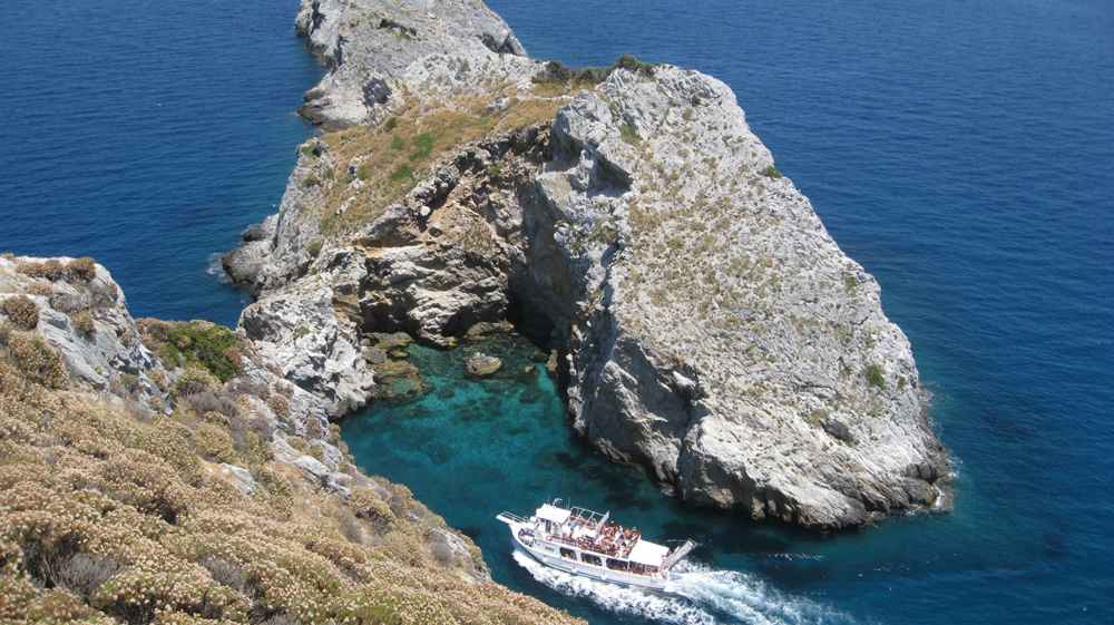
Three sea caves punctuate the cliffs west of Lalaria, and the excursion boats work them into every round-island route. Skotini, the dark cave, opens as a high vaulted chamber that small boats enter through a narrow mouth. Galazia, the blue cave. Glows with reflected light off its submerged floor. Halkini, the copper cave, takes its name from the metallic tones of its mineral-streaked walls. Skippers nose in when the swell allows and hold position while passengers photograph the water colours. Swim stops follow at coves along the same stretch, with ladders down from the stern.
The caves sit minutes apart by boat yet remain invisible from every road on the island, which is why the east coast only exists for visitors who board a boat.
Round-the-island trips leave the old port on summer mornings and turn the geography lesson into a day out. The classic circuit runs anticlockwise: south coast beaches from the sea, the western strait facing Pelion. The wild northern sand, then Kastro, the caves and Lalaria before the run home past the airport approach. The full loop takes most of the day with two or three swimming stops. Wooden caiques. Speedboats and larger excursion vessels all sell the same basic route from boards along the harbour. Passengers watch the four zones of the island scroll past in sequence, which makes the boat day the fastest way to understand the layout.
Photographers sit port-side outbound for the cliffs and starboard on the return for the town and the landing aircraft.
Weather writes the timetable on this coast. The meltemi blows from the north. The very stops that make the circuit famous. Lalaria, the caves. Kastro beach. Face directly into it, so operators cancel or reroute on strong-wind days and run the sheltered south instead. Morning departures beat the wind’s midday peak, and June and September deliver the highest completion rates for the full loop. Tsougria islet, facing the harbour mouth about 15-25 minutes across the channel, serves as the reliable fallback: its sandy northwest beach stays swimmable in winds that close the north.
Travellers with a fixed wish to see Lalaria book the boat for their first available day rather than the last, keeping a spare day in reserve for a second attempt.
How does Kastro fit into the Skiathos map?
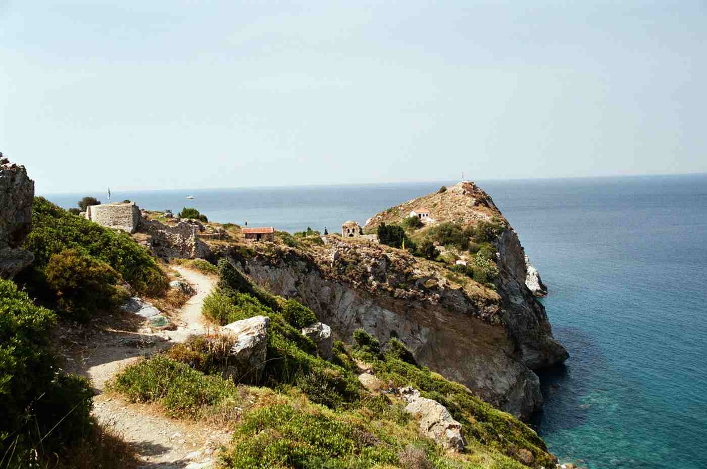
Kastro crowns a sheer promontory on the island’s northern tip, the site of the fortified medieval capital. Access runs three ways: road plus a final footpath, the cross-island hiking trail, and excursion boats stopping at the beach below.
The promontory explains the settlement. Islanders abandoned the ancient harbour town during the era of pirate raids and rebuilt on this sheer rock. Connected to the island only by a drawbridge, where the community remained through the Venetian and Ottoman centuries. The population moved back to today’s harbour site after the Greek War of Independence, leaving the cliff town to the wind. On the map, Kastro therefore marks the island’s historical centre of gravity displaced to its most defensible corner. The exact opposite logic to the modern town. Which spreads around the safest anchorage. The ruins of roughly 300 houses and more than 20 churches cover the rock, with gates.
Cannons and a handful of restored churches surviving among the collapsed walls and stairways of the abandoned lanes.
Reaching Kastro takes deliberate effort by every route, which keeps the site quiet. Drivers follow the inland roads north until the tarmac gives way to track. Park at the road head and walk the final 15-20 minutes down a stepped footpath to the gate. Hikers take the marked spine trail from Skiathos Town via the Evangelistria monastery, about 3-3.5 hours one way with shade for long stretches. Boat passengers land at the pebble beach below the rock on round-island itineraries and climb the path to the gate in about 15 minutes. The three approaches suit three different days: a rental-vehicle north-coast loop, a full walking day, or the standard boat circuit with a built-in history stop.
Signposting stays clear on all three, and the final path suits anyone steady on steps.
The surviving buildings reward the climb. The church of Christos, the Church of the Nativity. Keeps post-Byzantine frescoes and a carved wooden iconostasis behind its plain stone front. The restored gate frames the same sea approach that pirates once faced. Cannons still point from the rampart line. Cisterns. Thresholds and wall stubs trace the street plan of a town that once held the whole island’s population on a rock the size of a village square. Kastro beach below serves swimmers between boat arrivals, with clear water over pebbles and a seasonal canteen operating on peak days. Interpretive panels stay sparse, so visitors who read the layout in advance. Gate, main lane, church terrace, rampart edge.
Take twice as much from the same hour on the rock.
Views tie Kastro into the rest of the map. The rampart edge looks east along the limestone coast toward Lalaria and the sea caves, the stretch no road touches. West over the empty northern bays toward Kechria and Aselinos. On clear days the Pelion peninsula closes the horizon behind the strait. The panorama makes the promontory the best free lesson in island geography: the whole roadless quarter spreads out below in one glance. Combining Kastro with a boat day covers the entire north in a single itinerary. Caves, Lalaria. The beach landing and the climb.
Turning the medieval capital into the hinge of the island’s wild side.
How do the airport and port shape a Skiathos itinerary?
Both entry points sit beside Skiathos Town on the southeast corner, so every stay starts there. Arrivals distribute west along the south-coast road by bus, taxi or rental vehicle, then branch north by track and east by boat.
The airport occupies the isthmus about 2 km north of the town waterfront, and its position compresses the arrival to a formality. Taxis cover the run to town in about 5 minutes. The seasonal bus and hotel shuttles serve the corridor. Transfers to the farthest hotels at Koukounaries finish inside about 30 minutes. The runway’s fame adds a spectacle to the map itself: arriving aircraft cross the public road at the threshold. The fence line and the old-port breakwater fill with photographers on summer afternoons. Departing travellers reverse the logic, swimming at Megali Ammos or Xanemos until two hours before the flight.
No other Greek island squeezes the distance between beach towel and boarding gate into so short a transfer. Even the wait for boarding comes with a runway view.
The ferry quay stands on the town’s eastern waterfront beside the Bourtzi. Boats arrive from Volos and Agios Konstantinos on the mainland. With onward connections east to Skopelos and Alonnisos and seasonal links from Thessaloniki and Mantoudi on Evia. Fast boats cover the Volos run in about 1.5-2.5 hours. Foot passengers step off within 300 metres of the bus terminus, the taxi rank and the old port, so the whole transport interchange fits inside one harbour view. Anyone still weighing routes and seasons reads the full breakdown of how to get to Skiathos before booking, because the choice between flying and sailing decides whether the trip starts at the isthmus fence or under the Bourtzi pines.
Sailing suits travellers who pair the island with Skopelos and Alonnisos further east.
Base choice follows the map’s zones. First visits and boat-heavy plans favour Skiathos Town or Megali Ammos, where the quays, the bus terminus and the evening waterfront sit within a walk. Families gravitate to the mid-coast bays — Achladies, Troulos, Agia Paraskevi — where sand shelves gently and the corridor noise fades. Beach-first travellers book the Koukounaries end and accept the 30-40 minute bus ride for town evenings. Couples who want quiet with reach choose Kanapitsa or Vassilias, one lane off the corridor. The island’s size forgives every choice: the difference between the best and worst-placed base amounts to about 25 minutes of road. Not the hour-long transfers that larger islands impose on a wrong guess.
Bus stop numbers in every hotel listing make the comparison quick before booking.
A four-day spatial plan covers the whole map without repetition. Day one works the south corridor by bus: Koukounaries at stop 26, the headland walk to Banana or Agia Eleni, and the return for a waterfront evening. Day two takes the round-island boat for Kastro, the caves and Lalaria, weather permitting. Day three uses a rental quad or jeep for the north. Kounistra monastery, Megas Aselinos. The Kechria descent. And day four crosses the interior on foot from town via Evangelistria to Kastro or down the dune path to Mandraki. Each day exhausts one zone and one transport mode. The evenings all end at the same harbour.
Which is the quiet advantage of an island where every route, road and boat line radiates from a single corner.
Frequently Asked Questions
Do you need a car to explore the whole Skiathos map?
A car is unnecessary for the south coast and essential for the north. The bus line with its numbered stops 1-26 covers every beach along the 12 km corridor from Skiathos Town to Koukounaries. Running about every 15-30 minutes at peak. Water taxis from the old port add a sea route to the same sand. Boats handle the entire east coast regardless of what anyone drives, because Lalaria and the sea caves have no road at all. The gap sits in the north and the interior: Megas and Mikros Aselinos. Kechria and Ligaries lie at the end of dirt tracks that no bus serves. A quad, jeep or careful scooter handles those surfaces best.
The efficient pattern is a rental for one or two chosen days rather than the whole week. Bus days on the corridor. One boat day east, one vehicle day north. Feet for the town lanes and the marked trails.
Which area of the Skiathos map suits a first visit best?
Skiathos Town and the Megali Ammos strip suit a first visit best, because both quays, the bus terminus, the taxi rank and the evening waterfront sit within a short walk. A first-time base there turns every zone of the island into an easy day: stop 1 of the bus line for the beach corridor. The old port for boat trips east. The rental offices for a north-coast day. Megali Ammos adds a long sandy beach about 1 km from the harbour while keeping the town within a 15-20 minute walk. Families with a beach-first plan do better mid-coast at Achladies, Troulos or Agia Paraskevi, where the sand shelves gently and nights run quieter.
Dedicated beach stays point to the Koukounaries end, accepting a 30-40 minute bus ride for town evenings. The distances stay small in every case — the worst-placed base on the island sits only about 25 minutes of road away from the best one.
How long does it take to cross Skiathos end to end?
Driving the paved corridor from Skiathos Town to the Koukounaries loop takes about 25-30 minutes over roughly 12 km. The bus needs about 30-40 minutes for the same run, stretching with every bell-press along the 26 numbered stops. Crossing the island the other way, south to north on foot. Takes about 3-3.5 hours on the marked spine trail from the town waterfront via the Evangelistria monastery to Kastro on the northern tip. Vehicles reach the north coast in about 20-35 minutes despite shorter distances, because the tracks past Kounistra and toward Aselinos run slow over dirt and stone. The full circumnavigation by excursion boat fills most of a day with swimming stops at Lalaria and the caves included.
The numbers add up to the island’s core planning fact: no journey between any two points on the map exceeds about half an hour by road. Half a day on foot or one full day by excursion boat at sea.
Which north-coast beaches on Skiathos can you reach by vehicle?
Megas Aselinos, Mikros Aselinos, Kechria and Ligaries are the vehicle-accessible north-coast beaches, all at the end of dirt tracks rather than tarmac. Megas Aselinos takes the track from the Troulos junction past farmland to a rough parking area behind the dunes. Mikros Aselinos branches off the Kounistra monastery road. The Kechria track leaves the inland road beyond the Evangelistria turn. Passing the frescoed monastery of Panagia Kechria before dropping to the cove. Ligaries lies further along the same northern stretch with a seasonal canteen in high summer. A quad, jeep or carefully ridden scooter suits the surfaces; low cars scrape on the ruts and rental terms often exclude the damage.
Mandraki and Elia stay out of reach for every vehicle. The only approach is the 25-30 minute dune path on foot from the Koukounaries area. And Lalaria remains boat-only below its cliffs. Kastro allows a drive to the road head plus a 15-20 minute walk.
Which side of Skiathos stays calm when the meltemi blows?
The south coast stays calm in the meltemi, because the island’s pine ridge blocks the north wind and leaves the bays from Megali Ammos to Koukounaries flat while the open north takes real waves. The wind arrives on summer afternoons in July and August. The effect splits the map in two: Vromolimnos, Troulos, Agia Paraskevi and the rest of the corridor keep glassy water and full sunbed rows, while Megas Aselinos, Kechria and Mandraki turn to surf and the boat stops at Lalaria, the caves and Kastro beach face cancellation. Excursion operators reroute to the sheltered side or postpone on strong-wind days, and morning departures beat the midday peak.
Tsougria islet opposite the harbour stays swimmable on its northwest beach through most blows, making it the standard fallback. Travellers therefore keep boat plans flexible and save the south-coast beach days for the windiest afternoons, when the sheltered corridor performs exactly as the map promises.
Where is Lalaria on the Skiathos map and how do you reach it?
Lalaria sits on the northeast tip of Skiathos, a curve of smooth white pebbles under pale limestone cliffs with the Tripia Petra rock arch at its edge. No road or footpath descends the cliffs. The beach is reached only by sea: excursion boats and water taxis leave the old port of Skiathos Town on summer mornings. Either as a direct run or as the headline stop on the round-the-island circuit that also visits the Skotini, Galazia and Halkini sea caves and the beach below Kastro. The crossing along the east coast takes under an hour by direct boat.
The beach itself carries no facilities, no shade and no sunbeds, so water, a hat and swim shoes for the hot pebbles travel with each visitor. Removing pebbles is prohibited and fined. North wind cancels the stop, which places Lalaria early on any itinerary — booked for the first calm day rather than the last day of the stay.
How walkable is Skiathos without any transport?
Skiathos ranks among the most walkable Greek islands, with the town, one proper beach and a monastery all reachable on foot from the harbour. Megali Ammos begins a 15-20 minute walk south of the waterfront, Xanemos sits past the runway fence. The Evangelistria monastery stands about an hour up the signed track from town. The waymarked trail network then extends the range: numbered routes of 3-8 km one way link the town to Kastro across the spine in about 3-3.5 hours. Drop to Kechria past its frescoed monastery. Thread the pines from Kounistra toward Mikros Aselinos.
The dune path to Mandraki and Elia adds a 25-30 minute forest walk from the Koukounaries end, itself reachable by bus for the price of a ticket. Shade covers long stretches, distances stay short, and fountains exist at the monasteries. Proper shoes matter on the stony surfaces, and the bus line waits as a return option at the corridor end of most routes.