
The history of Skiathos runs from Chalcidian colonists of the archaic era to the novelist Alexandros Papadiamantis. His fiction fixed the island in Greek literature. Herodotus placed the opening naval clash of Xerxes’ invasion in its waters, and fire signals from its hills warned the Greek fleet at Artemisio. Medieval islanders abandoned the ancient harbor town for the fortified rock on the north coast and lived there behind a drawbridge for more than four centuries. Plan the whole trip with Greece Tours.
This guide follows the story in order across five chapters. It opens with the first settlers and the ancient name, then covers the classical polis with its coins and Athenian alliances. The middle chapter examines the island’s role in the Persian Wars. The final two trace the medieval flight to the fortified rock and daily life there under Venetian and Ottoman rule. Concrete places anchor every chapter, from the twin harbors of the ancient town to the drawbridge gate on the northern cliffs. Readers can match each era to ground they can still walk.
What was the ancient name of Skiathos and who were its first settlers?
Skiathos has carried the same name since antiquity, and Chalcidian colonists from Euboea founded its first organized town in the archaic era, settling on the low peninsula where Skiathos Town stands today, above two natural harbors.
The name Skiathos appears in ancient texts, medieval documents, and modern charts without alteration. That continuity is unusual in an archipelago where conquerors renamed harbors repeatedly. One ancient tradition derives the name from skia, the Greek word for shadow, because dense pine forest darkened the slopes above the twin harbors. A second tradition assigns the shadow to Mount Pelion on the Magnesia peninsula. Its ridge rises across the strait and blocks the low winter sun from the northern coast. Ancient geographers grouped the island with Skopelos and Alonissos in the Northern Sporades. The same name covered both the island and its principal town, which stood on the peninsula now occupied by the modern port.
Sailors bound for the Thermaic Gulf used the island as a fixed landmark.
Ancient authors credited Pelasgians from Thrace with the earliest settlement, placing them on the island before written records began. The tradition survives in later Greek literature rather than in local inscriptions, so the Pelasgians remain names without faces in the island’s story. Geography explains the early attraction: the southeast coast holds a deep, sheltered bay, winter streams deliver fresh water, and pine forest supplied timber for boats and roofs. Fishing grounds in the strait toward Euboea provided food in every season. Early inhabitants favored the ground near the natural harbors over the exposed northern cliffs. Every later settlement repeated that preference until the medieval flight to the north coast.
The pattern set by these first unnamed families decided exactly where the ancient town eventually rise.
Chalcidian colonists from the city of Chalcis on Euboea founded the organized ancient town during the archaic era. The same colonizing expansion carried Euboean settlers north to Chalkidiki and west to southern Italy. Chalcis lay about eighty kilometers to the south, a short passage along the Euboean coast. Its sailors knew the strait past Skiathos as the main sea route north toward the Thermaic Gulf. The colonists brought the Greek alphabet, olive cultivation, and the political habits of a Euboean polis. They chose the low peninsula between two natural harbors, the same ground the modern town occupies. Trade in timber, wine, and fresh fish tied the new settlement to its mother city.
The link extended to the wider network of Euboean colonies across the northern Aegean.
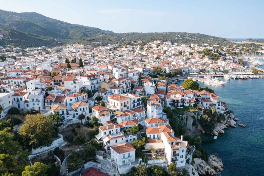
The ancient town covered the peninsula of the present-day port, with the Bourtzi islet dividing its waterfront into two separate harbors. A fortification wall enclosed the settlement on the landward side, and quays served merchant traffic in both basins. Continuous habitation buried most classical remains beneath later buildings. Surviving traces amount to wall foundations plus scattered architectural fragments that masons reused in newer structures. Excavation opportunities stay rare because the modern town sits directly on top of the ancient street plan. The twin-harbor arrangement gave shelter from both the northern meltemi wind and southern gales, an advantage no other anchorage on the island matched.
That practical geography, chosen by colonists in the archaic era, still defines the shape and the working life of the port today.
How did the classical polis of Skiathos govern itself and mint its coins?
The classical polis of Skiathos held the ancient town above the twin harbors, minted its own bronze coins, and appears in Athenian tribute records as a small member of the Delian League.
The classical polis of Skiathos operated as a small self-governing city-state with an assembly, magistrates, and its own civic identity. Its population was counted in the low thousands. Public life centered on an agora near the harbors, where fishermen, farmers, and traders exchanged goods and news. The countryside supplied olives, grapes, and grain from terraced plots, while pine resin and timber left the island as exports. Defensive walls protected the town during the recurring wars of the classical era. Control of the northern sea lanes passed between Athens, Sparta, and Macedon in those conflicts. Small size never removed the island from great-power politics.
The position on the shipping lane running north toward the Hellespont made every fleet commander of the era note its two harbors.
Bronze coins minted on Skiathos announced the polis to the wider Greek world during the classical era. Surviving issues carry the head of the god Hermes on one face. The reverse shows his herald’s staff, the caduceus, beside an abbreviated form of the city’s name. Hermes suited a trading community, since Greeks honored him as protector of merchants, travelers, and sailors. The coins circulated locally and in the ports of the Pagasetic Gulf and Euboea, paying for harbor fees, fish, and ferry passages. Minting required civic organization, engraved dies, and a steady metal supply, so the coinage stands as direct evidence of an organized municipal government.
Museum collections in Athens and abroad preserve examples, and the types remain the clearest statement of how the islanders presented themselves.
Athenian tribute records list Skiathos among the members of the Delian League, the naval alliance Athens organized after the Persian Wars. The island’s assessment stayed small, measured in hundreds of drachmas rather than talents, reflecting a modest economy of fishing, farming, and timber. Spartan forces took control after the Peloponnesian War ended in Athenian defeat, and a Spartan garrison watched the strait for a generation. The island then joined the Second Athenian League in the fourth century BC, returning to the alliance system of its longtime trading partner. Loyalty followed geography here. Athenian fleets guarded the sea lane that ran past the island toward the Hellespont.
Membership in Athens’ alliances kept the twin harbors open to the steady maritime traffic that fed the small local economy.
Macedonian power ended the town’s independence in the Hellenistic era. Philip V of Macedon ordered the settlement destroyed in the late third century BC. The demolition denied its harbors to the Roman and Pergamene fleets operating against him. The islanders rebuilt, and the town recovered as a minor port under Macedonian and then Roman control. Rome later placed the island under Athenian administration, when Mark Antony granted it to Athens along with neighboring islands. Athenian officials then managed its affairs deep into the imperial centuries. Quiet followed the transfer: the island produced wine, olive oil, and timber for regional markets while the great trade routes shifted elsewhere.
The long Roman peace left monuments, and the next dramatic chapter waited for the insecurity of the medieval Aegean.
What role did Skiathos play in the Persian Wars?
Skiathos witnessed the opening naval clash of Xerxes’ invasion, when ten Persian ships attacked three Greek scouts off its coast, and fire signals from the island warned the allied fleet waiting at Artemisio.
Herodotus records the opening naval action of Xerxes’ invasion in the waters off Skiathos. Three Greek ships, one each from Troezen, Aegina, and Athens, kept watch near the island. Ten fast Persian vessels from the fleet’s advance squadron bore down on them. The Persians took the Troezenian ship first and killed a marine named Leon on its prow. The Aeginetan ship fell next after its marine Pytheas fought until badly wounded; his captors dressed his wounds and honored his courage. The Athenian crew ran their ship aground far to the north near the mouth of the Peneios river and escaped overland through Thessaly.
Greek blood was spilled off Skiathos before the famous battles of Artemisio and Thermopylae had even begun. The invasion’s fighting truly started here.
Fire signals carried the news across the strait within the hour. Watchers on the heights of Skiathos lit beacons the moment the Persian squadron appeared. The flames warned the allied Greek fleet stationed at Artemisio on the northern coast of Euboea. The Greek commanders, alarmed by this first contact, withdrew temporarily down the Euboean channel toward Chalkis before returning to their station. The Persians meanwhile marked the hidden reef of Myrmex in the channel between Skiathos and the Magnesia coast. Their crews set a stone pillar on the shoal to guide the invasion fleet safely past the hazard. The episode fixed the island’s place in Herodotus’ narrative as a forward observation post.
Its hills gave the Greeks their earliest warning of the fleet that came to conquer them.
Local tradition ties the great Persian invasion fleet to Mandraki bay on the island’s northwest coast. The sheltered anchorage there carries the name harbor of Xerxes. Tradition holds that Persian ships watered and sheltered on its sands during the campaign. The bay sits behind a belt of pine forest and dunes, about a forty-minute walk from Koukounaries. Its shallow, protected water explains why the story attached to this shore rather than the exposed northern cliffs. Herodotus places the main fleet’s catastrophe nearby. A three-day storm off the Pelion coast wrecked hundreds of Persian vessels before the fighting at Artemisio opened. The strait the invaders needed to pass runs directly within sight of Mandraki.
That geography keeps the old tradition credible even where the historian stays silent.
The battles that followed gave the island’s waters lasting fame. Greek and Persian fleets fought three engagements off Artemisio during the same days as the stand at Thermopylae, within a day’s sail of Skiathos. The strait between the island and the Magnesia coast formed the invasion route’s narrowest maritime gate. The Greeks posted their scout ships there first for exactly that reason. Naval historians treat the skirmish off Skiathos as the first recorded clash between Greek and Persian ships in the invasion. The small action holds an outsized place in the record. Visitors who stand on the northern cliffs today look across the same water Herodotus described.
The view takes in Pelion, the reef line, and the channel where the largest fleet of the age sailed south.
Why did the people of Skiathos move to Kastro in the medieval centuries?
Pirate raids drove the islanders from the exposed harbor town to Kastro, a sheer promontory on the north coast, during the fourteenth century, and the rock remained the island’s only settlement for more than four centuries.
Byzantine administration held the island for long centuries after the division of the Roman world, taxing it lightly and defending it only rarely. The Fourth Crusade broke that order. In the early thirteenth century the Ghisi brothers, members of a Venetian family, took Skiathos and its Sporades neighbors as a private lordship. The Ghisi built the Bourtzi fortress on the islet between the town’s two harbors. The compact strongpoint’s walls still frame the entrance to the modern port. Venetian and Byzantine control alternated over the following generations as the empire recovered and weakened again. Through all of it the islanders stayed in the old coastal town, exposed on its low peninsula.
The sea around them filled with raiders that no distant government proved able to police.
Corsair raids made the coastal town unlivable in the fourteenth century. Raiding crews from North Africa and Anatolia struck Aegean harbors for slaves and cargo. A low, open peninsula beside two harbors offered no defense against them. The islanders answered with one total relocation: they abandoned the entire ancient site and rebuilt on Kastro, a sheer promontory on the far north coast that the sea guards on three sides. The choice traded convenience for survival. Fields, boats, and fishing grounds now lay long hours away on foot, yet the rock’s cliffs stopped raiders where walls on flat ground had failed. Communities across the Aegean made the same retreat in the same centuries.
They moved from open beaches to fortified heights until the sea became safe again.
The rock of Kastro rises about sixty meters straight from the sea at the island’s northern tip. A single narrow neck connects it to the rest of the island. The medieval builders cut this away and replaced it with a wooden drawbridge that defenders raised at any alarm. A fortification wall with a gate closed the landward approach, and cannon platforms covered the bridge and the water below. Cisterns caught rainwater, since the rock holds no spring of its own. Paths inside climbed between houses stacked on the slope, packed tight against one another to fit the small summit. Every element served defense first, and comfort came second.
The rock was chosen precisely because it was hard to reach, hard to climb, and simple to seal shut.
Kastro grew into a complete town on its confined summit. At its peak the settlement held about three hundred houses and about thirty churches. A population near two thousand people lived inside the walls. Streets ran barely wide enough for loaded mules, and flat roofs doubled as work space for drying fish and figs. The churches, small and barrel-vaulted, anchored neighborhood life, and two of them still stand today with frescoes and carved icon screens intact. Farmers descended the cliff paths each morning to reach their small terraced plots and returned before dark. The community kept that daily rhythm for hundreds of years.
The rock’s meager area forced a discipline in building, water use, and food storage that shaped island habits long after the walls emptied.
What was life like at Kastro under Venetian and Ottoman rule?
Life at Kastro combined confinement with security: Venetian rule brought naval obligations and written privileges, Ottoman rule after Barbarossa’s siege brought taxation with self-government, and about thirty churches served the walled community on the rock.
Venetian authority returned to the island in the fifteenth century, when the Republic took direct control of the Sporades from its weakening Byzantine ally. Venice ruled Kastro through a rector and local notables and granted the community written privileges. The Republic folded the island into the naval system that guarded its trade convoys through the Aegean. Islanders owed service and taxes, and in exchange Venetian galleys deterred the corsairs that had driven them onto the rock. Trade revived within limits, with fish, wine, and timber moving toward Venetian harbors in the southern Aegean. The arrangement held for about a century. Its legal habit of communal representation before a distant power survived into the Ottoman period.
Kastro thus kept a continuity of self-government that outlasted its successive rulers.
Hayreddin Barbarossa, the Ottoman admiral, ended Venetian rule in the mid-sixteenth century. His fleet besieged Kastro, whose defenders held the drawbridge and the walls for days against an overwhelming force before the rock finally fell. The aftermath was brutal, with surviving captives carried off into slavery, a fate Barbarossa’s campaigns inflicted across the Aegean islands in those same years. The island passed under Ottoman administration and remained there for nearly three long centuries. Survivors rebuilt their community on the same rock, since the sea stayed dangerous and the reasons for living behind cliffs had not changed. The siege entered island memory as the community’s darkest hour.
It marked the hard boundary between the Venetian and Ottoman chapters of life on the northern promontory above the sea.
Ottoman administration taxed Kastro but largely left it alone. The islanders paid the head tax, kept their Orthodox parishes, and ran communal affairs through elected elders. The elders answered to Ottoman officials based on distant Euboea. No Turkish community settled on the rock, so daily life stayed Greek in language, worship, and custom through the whole occupation. Fishing, small-scale farming, and boatbuilding sustained the economy, and island captains gradually built the seafaring skill that later carried their descendants across the Mediterranean. Monastic life expanded in the island’s wooded interior during the late Ottoman centuries. The monasteries drew monks who sought distance from both the authorities and the sea lanes.
Kastro’s isolation, once a wartime necessity, hardened into a settled way of life that lasted until the independence era changed everything.
The community finally left the rock in the independence era. Greek victory over the Ottomans made the coasts safe for the first time in half a millennium. Families dismantled their stone houses, carried timber and roof tiles down the cliff paths, and rebuilt on the ancient town site above the twin southern harbors. Kastro emptied within a single generation, leaving its churches, walls, and cisterns to the wind and the goats. The new town soon produced the island’s most famous son, the novelist Alexandros Papadiamantis, born there in the nineteenth century. He set his fiction among Kastro’s ruins and the fishing families descended from its people.
His restored home, the Papadiamantis House, preserves that vanished world and closes the circle that the first Chalcidian colonists opened.
How did the Evangelistria monastery of Skiathos serve the Greek independence era?
Kollyvades monks from Mount Athos founded the Evangelistria monastery in the late eighteenth century.
The Evangelistria monastery occupies a pine slope about 4 km north of the harbour, above the wooded gorge of the Lechouni stream. Kollyvades monks founded it in the late eighteenth century after leaving Mount Athos, where their movement for strict liturgical observance had lost a dispute. Skiathos offered the exiles isolation, spring water and timber, and the brotherhood raised a fortified complex around a stone-paved courtyard. The katholikon, dedicated to the Annunciation of the Virgin, follows the Athonite plan with a central dome, three apses and a marble floor. Cells, cisterns, an olive press, a bakery and storerooms filled the surrounding wings.
Within a generation the monastery controlled chapels, vineyards and farmland across the island and stood as the strongest religious and economic institution on Skiathos.
Fighters of the independence era found food, powder and shelter behind the monastery walls. Tradition holds that weavers on the monastery loom produced a revolutionary banner, a white cross set on a sky-blue field. The abbot blessed it before assembled captains in the courtyard. Island accounts name Theodoros Kolokotronis, Andreas Miaoulis, Thymios Vlachavas, Yiannis Stathas and the priest-rebel Nikotsaras among the men who swore loyalty beneath the raised flag. The design anticipated the colours later adopted by the Greek state, and islanders call Skiathos the birthplace of the national flag. A replica of the banner hangs in the monastery museum beside the wooden loom that tradition credits with the weaving.
A carved stone plaque in the inner courtyard marks the site linked with the oath.
Armatoloi and klephts from Mount Olympus, Thessaly and Macedonia used Skiathos as a rear base during the long armed resistance to Ottoman rule. Their crews beached armed caiques in the northern coves below Kastro and drew supplies from the monastery estates. Nikotsaras, the priest turned raider, and the captain Yiannis Stathas commanded flotillas that harassed Ottoman shipping through the Sporades channels. The monastery paid a heavy price for this support: Ottoman punitive expeditions raided the island, and the brotherhood buried its hidden treasures and dispersed until each threat passed. Island tradition preserves accounts of grain, oil, lead and weapons handed to the fighters at the monastery gate.
The bond between the fighting clergy and the revolution gave the Evangelistria its lasting place in national memory.
Visitors today enter the monastery free of charge through the north gate, with shoulders and knees covered under the posted dress code. The museum wing displays manuscripts, icons, vestments, weapons of the independence era and the flag replica in a sequence of small rooms. Monks cultivate vines on the terraces below the walls, and the shop sells the estate’s own Alypiakos wine together with honey, olive oil and beeswax candles. A paved road climbs from the town ring road, and the drive from the old harbour takes about ten minutes. Walkers reach the gate in about one hour on the signed path from the town that passes the skete of Agios Charalambos.
The terrace by the main gate overlooks the town and the harbour below.
Why did the people of Skiathos return from Kastro to the harbour town?
Piracy collapsed once the Greek state secured the Aegean, removing the reason for the cliff-top refuge. Islanders dismantled Kastro house by house, carried its timber and stone south by boat, and rebuilt on the ancient harbour site.
The exodus from Kastro unfolded over years rather than in a single season. Families pried roof timbers, door frames and dressed stones from their cliff houses. Crews loaded them onto boats at the small landing below the rock and ferried the material down the east coast. Elderly residents and the poorest households stayed longest, and the last inhabitants abandoned the citadel within a generation of the first departures. The demolition explains why Kastro survives only as foundations, cisterns and restored churches: the town itself walked away with its own building stock. Priests carried the icons and iconostases south, and land inside the walls reverted to grazing. Shepherds and beekeepers remained the only regular visitors for over a century.
Boat crews on island tours still point out the landing rock the movers used.
The settlers laid out Skiathos Town across two low hills flanking the Bourtzi peninsula, on the exact site of the classical polis. The plan gave the island two harbours. The old harbour on the southwest side served fishing boats and boatyards, and the deeper roadstead on the northeast took trading vessels. Lanes climbed the hills in tiers, and each neighbourhood gathered around a parish church. Houses followed a two-storey pattern with stone ground floors, timber balconies and tiled roofs, closer to Pelion mansions than to Cycladic cubes. Water came from wells and cisterns through the town’s first decades. The amphitheatre form still shapes the town.
Ferries arriving from Volos and Agios Konstantinos face the same rising crescent of white walls and red roofs that greeted the first returning families.
The Bourtzi peninsula dividing the two harbours carries the story of medieval Skiathos in miniature. The Gyzi brothers, Venetian adventurers, took the Sporades after the Fourth Crusade and raised a fortress on the islet in the thirteenth century. Their successors ruled from it until pirate pressure pushed the population north to Kastro. Ottoman rule left the fort to decay, and the returning townspeople quarried it for building stone. A neoclassical building rose among the ruins as a school, and the pine-shaded promontory now serves as a cultural centre with an open-air theatre. Sections of the medieval wall survive along the water line. Fishing boats tie up in its shadow on the old-harbour side.
The five-minute walk around Bourtzi passes cannon emplacements, the war memorial and views over both harbours.
Church-building anchored the new town from the first years of the return. The cathedral of Tris Ierarches rose near the old harbour and received the island’s most venerated icon, the Panagia Eikonistria. A monk had found the icon hanging in a pine tree in the interior. Builders set carved stones, icons and iconostases from the Kastro churches into the new parishes, so fragments of the medieval town survive inside the modern one. Bell towers of Agios Nikolaos and Panagia Limnia rose on the hills as landmarks for returning fishermen. Feast days still follow the calendar the settlers carried down from the rock.
The icon of the Eikonistria travels in procession from its hillside chapel to the town each late autumn. The procession retraces the road between the island’s old and new centres.
How did Skiathos become a literary island in the nineteenth century?
Skiathos produced two leading figures of modern Greek prose in the nineteenth century. Alexandros Papadiamantis wrote about 170 stories and novellas set largely on the island, and his cousin Alexandros Moraitidis matched him with fiction, travel writing and religious verse.
Alexandros Papadiamantis was born in Skiathos town, the son of the island priest Adamantios Emmanouil. He grew up between the parish churches and the boatyards of the old harbour. Poverty stretched his schooling across islands and years: classes on Skiathos, then Skopelos, Chalkida and Piraeus before university studies in Athens that he never completed. He earned a thin living in the capital as a translator and journalist for Athenian daily papers. He rented cheap rooms and wrote fiction at night for serial publication. The island pulled him back throughout his life, and he returned for good in his final years. He died in the family house in the lane that now bears his name.
Islanders called him the kosmokalogeros, the worldly monk, for his austere and devout habits.
His fiction turned Skiathos into one of the most closely mapped places in Greek literature. The Murderess, his darkest novella, follows the widow Frankogiannou across real ravines, sheepfolds and shoreline caves of the island. Around 170 short stories draw on the town’s lanes, the chapels of the interior and the seafaring households of his childhood. Priests, widows, shepherds, fishermen and emigrants populate the pages, rendered in a dense idiom that mixes church Greek with island speech. Scholars trace named locations from his pages on the ground: Kechria, Kastro and the Lalaria coast appear under their own names. Translations into English, French and German carry the island’s place names to readers who have never seen the Aegean.
Readers who walk the interior trails cross the same fords and olive terraces his characters cross.
Alexandros Moraitidis, his cousin and exact contemporary, built a parallel career in Athens as a journalist, playwright and writer of travel chronicles. His short stories mine the same island material: sailing voyages, monastic feasts and the fading world of the Kastro elders. His travel chronicles cover pilgrimages to Mount Athos, the Holy Land and the monasteries of the Aegean, written in the formal language of the church. Critics of the era printed the two cousins side by side, and readers treated them as a matched pair of Skiathos voices. Moraitidis returned to the island in old age, took monastic vows under the name Andronikos, and died soon afterwards.
His house in the town survives, and the municipality honours both writers with busts, street names and readings during summer cultural programmes.
The literary legacy structures how the island presents itself. The Papadiamantis House museum keeps his desk, manuscripts, icons, photographs and household objects across the two floors of the modest family home. The airport bears his name, a bust watches the old harbour from the Bourtzi entrance, and the central lane of the town is called Papadiamantis Street. Greek schoolchildren read his Christmas and Easter stories every year, which keeps a steady stream of literary visitors arriving outside the beach season. A commemorative festival of readings and music honours the two cousins in the town each summer. Walking routes link the house, the harbour churches and the hillside chapels of his stories.
The nineteenth-century town he described survives in pockets uphill from the rebuilt post-war waterfront.
What destroyed the town of Skiathos in wartime and how was it rebuilt?
German occupation forces burned a large part of Skiathos town in a reprisal raid during the final period of the Axis occupation. Residents rebuilt on the same street plan, raising the whitewashed two-storey houses that define the waterfront today.
Occupation forces controlled Skiathos during the Axis years, and the island’s position turned it into a link on a secret escape route. Caiques slipped out of the small eastern coves at night carrying stranded Allied soldiers, escaped prisoners, resistance couriers and Greek volunteers toward neutral Turkey and the Middle East. Fishermen and sponge captains ran the night crossings, navigating between patrolled channels with passengers hidden under nets and cargo. Andartes based in the Pelion mountains crossed to the Sporades for supplies and recovery. The islanders paid for this activity in requisitions, arrests and hunger, and the famine winter of the occupation reached Skiathos as it reached the rest of Greece.
Memory of those winters still marks family histories across the town and shapes how islanders retell the occupation.
German troops landed in strength late in the occupation and burned the harbour town in reprisal for the escape traffic and for resistance activity across the Sporades. Flames took the whole waterfront and climbed through the lanes, destroying a large share of the housing stock along with shops, boatyards and stored fishing gear. Families fled uphill to the chapels and olive groves and watched the town burn from the ridgelines. The parish churches on the two hills survived, as did clusters of stone houses on the upper slopes. Islanders still date family stories to before and after the fire, the way other towns date theirs to earthquakes.
The destruction closed the war years with the harshest blow the town had taken since the pirate centuries.
Reconstruction began as soon as peace returned, with island masons rebuilding on the old foundations and the old street plan. The two-storey format returned: whitewashed walls, timber balconies, tiled roofs and shuttered windows facing the harbour. State reconstruction funds and remittances from emigrant families financed the work, and the boatyards at the old harbour resumed launching caiques within years of the fire. Trades revived in the same order: fishing first, then shipwright work, then shops serving the returning households. The rebuilt waterfront reads as one architectural generation, which explains its unusual uniformity for a Greek island town. Uphill, surviving pre-war houses show the older, heavier masonry and carved stone details.
The mix gives the town two textures: a post-war seafront and an older core threaded along the upper lanes between the churches.
War memory stays visible for visitors who look for it. The war memorial on the Bourtzi promontory honours the island’s wartime dead, and wreath-laying ceremonies mark the national anniversaries each year. Guides on walking tours point out the boundary between post-war and pre-war masonry in the lanes above the old harbour. Pre-fire photographs reproduced in town cafés and guidebooks show the lost waterfront with its shipowners’ houses. Comparing those images with the modern seafront measures the loss precisely. Boatyard sheds at the old harbour keep the caique-building craft alive, a direct survivor of the pre-war economy.
Visitors who climb the Agios Nikolaos hill at dusk see exactly the layout the rebuilders preserved: the same lanes, the same church landmarks, the same amphitheatre facing the sea.
How do the airport and tourism display the history of Skiathos today?
The Alexandros Papadiamantis airport, built on drained wetland northeast of the town, connected Skiathos to direct charter flights and reshaped the economy around tourism. Monuments from antiquity, the medieval centuries and the independence era now anchor the visitor trail.
The runway of the Alexandros Papadiamantis airport crosses a strip of drained wetland between the town and Xanemos beach on the northeast coast. Engineers filled the marsh and laid a strip of about 1.6 km, one of the shorter commercial runways in Greece, with sea at both ends. Direct charter flights from Britain, Scandinavia, Italy and Central Europe land through the summer season, alongside domestic connections from Athens and Thessaloniki. The busy public road crossing the approach draws plane-spotters who film aircraft passing metres overhead. The fence line at the runway end ranks among the best-known aviation viewpoints in Europe. The terminal sits about 2 km from the town centre.
The airport’s name closes a circle: the island’s global gateway honours its most famous writer.
Tourism reshaped the island’s economy within a single generation of the airport opening. Hotel and studio construction spread along the south coast road from the town toward Koukounaries, following the bus line that links more than 60 beaches and pebble coves. Package operators from Britain and northern Europe filled the summer schedules. The permanent population of about 6,000 came to host hundreds of thousands of visitors across a season stretching from spring to autumn. Farming and caique fishing shrank to sidelines as families converted land into rooms, tavernas and rental fleets. Ferries from Volos, Agios Konstantinos and Mantoudi feed day arrivals alongside the flights.
The southern strip absorbs the growth, while the roadless northern coast keeps the older landscape of pine forest, cliff and cove.
History anchors the visitor trail at fixed points across the island. Boat trips round the island pause below Kastro, where restored churches, cisterns and the gate platform crown the rock. The Evangelistria monastery draws steady traffic for the flag story, the museum and the estate wine sold at the gate. The Papadiamantis House fills its rooms with the writer’s world, and Bourtzi layers Venetian walls, a neoclassical school and an open-air stage on one promontory. Wall foundations at Kefala near Xanemos mark an ancient settlement for walkers on the northeast paths. Tris Ierarches keeps the icon of the Panagia Eikonistria found in the interior pines. Taxis and the bus network reach every land stop.
Each stop matches one era of the island’s record, from the classical polis to the post-war rebuild.
Street names, feast days and boat schedules carry the historical record into daily life. Papadiamantis Street forms the town’s spine, the icon procession of the Eikonistria crosses the interior each late autumn, and excursion boats repeat the route refugees once rowed toward Kastro. Trail-restoration volunteers have reopened the mule paths that linked town, monastery and citadel, signing them for walkers. Museums stay modest in scale: a house, a monastery wing, a fortress platform. Tavernas on the old harbour serve fishing crews beside tour boats, keeping the working waterfront the rebuilders restored. Visitors cross the whole historical sequence in two days on foot and by boat, from the ancient harbour stones to the runway fence at Xanemos.
The sequence explains the island’s shape better than any single monument.
Frequently Asked Questions
Where can visitors see ancient traces of Skiathos history?
Ancient traces concentrate around the modern town and the northeast coast. The classical polis stood on the site of Skiathos town, and its harbour works lie under the modern quays, so the town itself is the principal ancient site. Wall foundations attributed to the ancient settlement survive at Kefala near Xanemos beach, reached on foot along the northeast coastal path. Mandraki bay on the northwest coast carries the tradition of Xerxes’ anchorage, and its name, meaning little harbour, preserves that memory. Walkers reach it through the pine forest behind Koukounaries. Coins minted by the classical city appear in museum collections in Athens and Volos rather than on the island itself.
Offshore, the strait between Skiathos and the Magnesia coast framed the first naval clashes of the Persian invasion, so the ferry crossing itself traverses the historical seascape. Visitors combine the Kefala walk, Mandraki bay and the town waterfront into a single day that covers the island’s oldest layer.
How do visitors reach Kastro and what remains there?
Kastro sits on a sheer peninsula at the island’s northern tip, and three approaches serve it. Excursion boats from the old harbour circle the island and land passengers below the rock, allowing about an hour among the ruins. Drivers follow the interior road to a parking area a short walk from the entrance steps. Hikers cross the island on signed mule paths in about three hours each way, passing chapels and spring-fed ravines. The medieval town once held about 300 houses and more than 20 churches inside its walls. Surviving structures include the gate platform where a drawbridge once hung, restored churches with fresco fragments and open cisterns.
The ruin of an Ottoman-era mosque and cannon on the seaward wall complete the circuit. Information panels explain the main buildings. The site has no shade beyond the church porches, so early visits work best in summer. Sturdy shoes matter on the worn steps, and the beach below the rock rewards swimmers after the ruins.
What is the story of the Greek flag on Skiathos?
The flag story belongs to the Evangelistria monastery in the island’s interior. Tradition records that fighters gathering at the monastery during the independence era needed a common banner. The monks wove one on the monastery loom: a white cross on a sky-blue field. The abbot blessed the flag in the courtyard. The assembled captains, with Theodoros Kolokotronis and Andreas Miaoulis named among them in island accounts, swore an oath of loyalty beneath it. The design prefigured the colours of the later national flag, and Skiathos claims the title of the flag’s birthplace on this basis. The monastery museum today displays a replica of the woven banner together with the wooden loom credited with the weaving.
A stone plaque marks the courtyard site of the oath. Historians debate details of dating and attendance, as with most revolutionary traditions. The island holds the story at the centre of its identity and retells it at every national anniversary.
Which Papadiamantis sites can visitors follow on Skiathos?
The Papadiamantis trail starts at the writer’s restored family house in a lane off the main street, now a museum keeping his desk, manuscripts, icons, photographs and household objects. Papadiamantis Street, the town’s central spine, carries his name from the harbour uphill, and a bust stands at the entrance to the Bourtzi promontory. His grave lies in the town cemetery. Story settings spread across the whole island. Kastro anchors the tales of the old refuge, the chapel country of the interior around Kechria appears throughout the fiction, and the Lalaria coast frames the sea stories. The airport arrivals hall greets visitors with his name before they see the town.
Readers time a visit with the winter and Easter feasts his stories describe, or walk the interior mule paths with a translated collection in hand. Allow half a day for the town sites and a full day for the story landscapes reached on foot or by boat.
What museum options does Skiathos offer for history?
Skiathos keeps its museums small, specific and close to their subjects. The Papadiamantis House in the town centre presents the writer’s life across the two floors of the family home, with original furniture, manuscripts and photographs. The Evangelistria monastery museum covers monastic craft and the independence era, displaying vestments, icons, printed books, weapons and the replica of the woven flag. Kastro functions as an open-air museum: restored churches, wall fragments and cisterns spread across the abandoned citadel, with information panels at the main structures. Bourtzi hosts rotating exhibitions and summer performances in the old school building among the Venetian ruins.
Parish churches, led by Tris Ierarches with the icon of the Panagia Eikonistria, hold icon collections and carved iconostases rescued from Kastro. Combined, the collections trace every era the island records, and all sit within walking or short boat range of the harbour. Entry fees stay low, and the monastery museum asks modest dress rather than money.
How does the layout of Skiathos town reflect its history?
The town plan reads as a historical document in three layers. The choice of site repeats antiquity: the two hills and double harbour of the classical polis dictated where the returning Kastro families rebuilt. The street pattern records the resettlement era. Lanes climb from both harbours in tiers, parish churches anchor the neighbourhoods, and the amphitheatre form faces the sea that fed the town. The building fabric records the wartime fire: the waterfront and lower lanes show uniform post-war construction, while the upper slopes keep heavier pre-war masonry and carved stone details. Bourtzi divides the harbours with its Venetian fortress ruins and neoclassical school, holding the medieval and modern layers on one promontory.
Even the traffic pattern is historical: the old harbour keeps fishing boats and caique yards, and the new mole takes the ferries. Walking uphill from either waterfront moves a visitor backward in time, from the rebuilt seafront to the oldest surviving lanes.
What themes run through books about the history of Skiathos?
Reading on Skiathos history circles a set of durable themes. Refuge and exposure lead the list: the island’s record swings between the open harbour town of peaceful eras and the cliff citadel of the pirate centuries. Faith and resistance follow, from the Kollyvades exiles who built the Evangelistria to the flag tradition and the fighting clergy of the independence era. The sea runs through everything. Naval clashes of the Persian invasion, corsair raids, sponge and caique fleets, wartime escape runs and the ferry and charter traffic of the tourism era fill the record. Papadiamantis dominates the literary shelf, and his fiction doubles as ethnography of the nineteenth-century town, its widows, priests and sailors.
Wartime destruction and rebuilding supply the modern chapters, with oral histories of the fire and the reconstruction. Recent titles add tourism itself as a subject, tracing how the airport and the beach economy remade island society within living memory. Translated story collections make the best starting point.