
To get from Chania to Anopoli, drive south on the E75/A90 to Vryses, then over the White Mountains toward Chora Sfakion and up the switchback road to the plateau, about 75 kilometres in 1.5 to 1.75 hours, reaching the Sfakia mountain village above Loutro. The trip from Chania to Anopoli climbs from the coast to 600 metres. Plan the whole trip with Greece Tours.
This guide covers the trip from Chania to Anopoli in full: where it is, how to drive it over the mountains, the limited bus, the green upland plateau and its village, the Sfakian hero Daskalogiannis and the history, the Aradena gorge and its iron bridge, the paths down to Loutro and Sweetwater beach, the White Mountains, and whether this high Sfakia trip is worth it.
Where is Anopoli and how far is it from Chania?
Anopoli is a mountain village in the Sfakia area of the Chania regional unit, sitting on a high plateau at 600 metres above sea level, above the coastal village of Loutro and the port of Chora Sfakion, 75 kilometres south of Chania.
Every itinerary that includes Chania to Anopoli gains an easy, scenic leg. The Chania to Anopoli journey ends at a place that repays an unhurried stay. Both the car and the bus make Chania to Anopoli a simple leg of a west-Crete plan. The drive from Chania to Anopoli is direct enough to slot into a wider day out. The village occupies the southern flank of the White Mountains, the great limestone range that fills the interior of western Crete. From the plateau the land drops in one abrupt wall to the Libyan Sea, and the shoreline of Sfakia lies directly below the settlement. Chania, the largest town in the west of the island, stands on the north coast, so the journey from Chania to Anopoli crosses the full width of the mountain massif, from the sheltered northern lowlands to the exposed southern edge of Crete.
The 75 kilometres between the two points are not flat kilometres. The first stretch runs along the fast north-coast corridor, then the route turns inland and climbs through a chain of upland basins before descending to the south coast and rising again to the plateau. This combination of distance and vertical relief is the reason the drive takes 1.5 to 1.75 hours rather than the single hour a straight 75-kilometre road demands. Anopoli sits at the end of one of the highest surfaced roads in Crete, and every visitor arrives by climbing to it.
Because it hangs above Loutro and Chora Sfakion, Anopoli is the natural mountain base for the whole Sfakian coast. The plateau looks down on the sea villages, the gorges cut through the range on either side of it, and the summits of the White Mountains rise directly behind the houses. Its position, high and remote yet reachable by a paved road, defines the entire character of the place.
How do you drive from Chania to Anopoli?
Drive south and east from Chania on the E75/A90 to Vryses, turn into the mountains through the Askifou plateau and the Imbros country down to Chora Sfakion, then take the switchback road that climbs from the south coast up to the Anopoli plateau \u2014 75 kilometres in 1.5 to 1.75 hours.
The drive from Chania to Anopoli is direct enough to slot into a wider day out. For a first visit, the Chania to Anopoli drive is the straightforward choice. The time from Chania to Anopoli holds steady outside the peak-season traffic. Travellers who plan the trip from Chania to Anopoli reach it comfortably in the times given. Leave Chania on the national road, the E75/A90, heading east along the north coast. The turn inland comes at Vryses, a green village of plane trees and springs where the mountain road begins. From Vryses the tarmac climbs steadily into the interior and reaches the Askifou plateau, a flat bowl of farmland ringed by peaks that marks the halfway point of the crossing. The road then continues through the Imbros country, passing the head of the Imbros gorge, before beginning the long descent toward the Libyan Sea.
The final drop to the coast is a series of tight bends that unwind down the mountainside to Chora Sfakion, the small port at the foot of the range. From the coast the road to Anopoli branches west and starts its climb, a genuine switchback ascent that gains 600 metres of altitude in a short horizontal distance. The bends are stacked one above the next, the guardrails hang over the sea, and the view back down to Chora Sfakion widens with each turn. This last section is the steepest and slowest part of the whole route, and it delivers the car onto the green upland plateau where Anopoli spreads out.
A rental car gives full command of this journey, and it is the sensible way to reach the plateau. Fuel the vehicle in Chania or at Vryses, because filling stations are sparse in Sfakia and absent on the plateau itself. Drive the mountain sections in daylight and unhurried, hold to the inside of blind bends, and yield to the buses and goods vans that use the same narrow lanes. For travellers building an itinerary, Anopoli slots naturally into a wider circuit of day trips from Chania that pair the mountain villages with the beaches and gorges of the south.
How do you reach Anopoli by bus?
The KTEL bus runs from Chania to Chora Sfakion across the mountains, and from Chora Sfakion a limited local service climbs to Anopoli on set days. Public transport reaches the coast reliably, but a rental car is the practical way onto the plateau itself.
The distance from Chania to Anopoli is covered on a single, well-built road. Fitting Chania to Anopoli into a morning leaves the afternoon free for the coast. The route from Chania to Anopoli runs the same way whether you drive or take the bus. The regional KTEL network links Chania with Chora Sfakion by a daily coach that follows the same road as a private car: east to Vryses, up through Askifou and Imbros, and down the switchbacks to the port. The service is timed to connect with the coastal ferries that run between Chora Sfakion, Loutro, Agia Roumeli and Gavdos, so it carries the walkers and beach-goers who make Sfakia their destination. The ride takes the better part of two hours and drops passengers at the harbour front, at sea level, well below Anopoli.
From Chora Sfakion up to the Anopoli plateau the connection thins to a small local bus that runs on set days rather than a full daily timetable. It climbs the switchback road, serves the plateau villagers and the trekkers heading for the gorges, and returns on a schedule built for local needs. A traveller relying on it must check the departure days at the port and plan the return with care, because a missed bus leaves few alternatives on the mountain.
For anyone who wants freedom of movement on the plateau \u2014 the trailheads, the Aradena bridge, the descent to Loutro \u2014 the bus falls short of what the terrain demands. Hiring a car in Chania and driving the whole route removes the dependence on set departure days and turns Anopoli from a hard-to-reach dot into an open base for the surrounding mountains and coast.
What is Anopoli like \u2014 the plateau and the village?
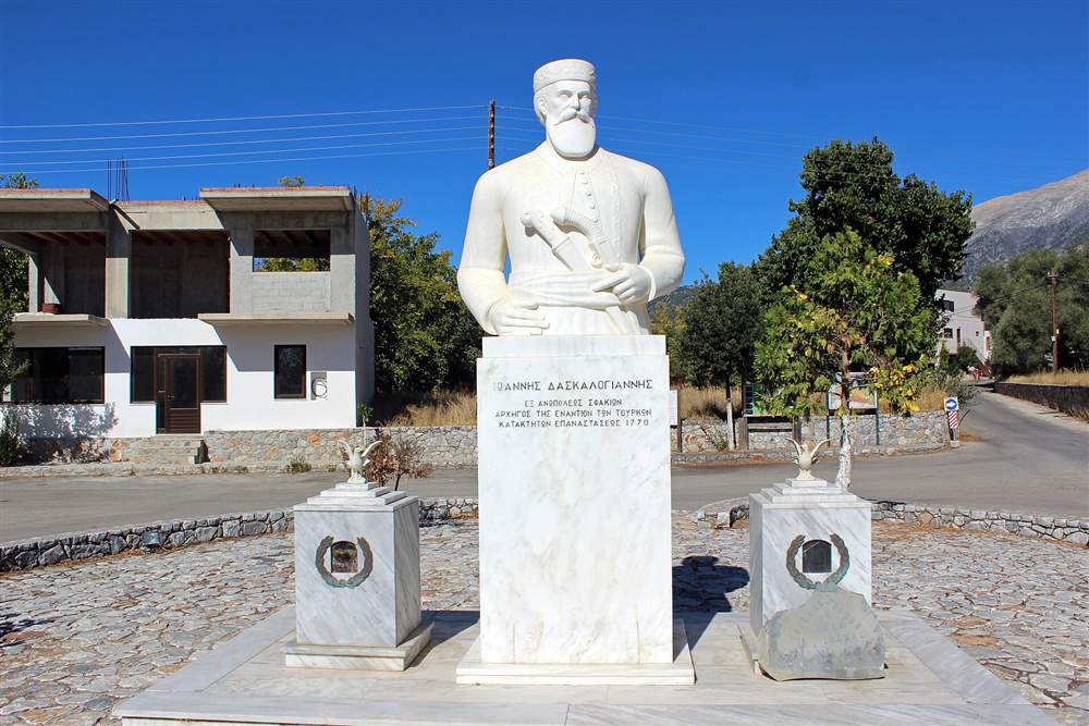
Anopoli is a scattered settlement of small hamlets spread across a green upland plateau ringed by the peaks of the White Mountains, built of stone houses grouped around a central square, with a statue of the Sfakian hero Daskalogiannis and the Byzantine church of Agios Georgios at its heart.
Setting out early on the Chania to Anopoli run beats both the heat and the crowds. The road from Chania to Anopoli is paved and well signed the whole way. Anyone weighing the journey from Chania to Anopoli finds the distance short by Cretan standards. The village is not one compact core but a loose constellation of hamlets strung across the flat top of the plateau. Stone houses stand among fields and olive terraces, low walls divide the grazing land, and the surrounding peaks close the horizon on every side. At 600 metres the air is cooler and sharper than the coast below, and the plateau stays green through the dry heat that scorches the shoreline. This upland basin grazes sheep and grows the food of Sfakia \u2014 the greens, the cheese and the honey that fill a Sfakian table.
The central square is the social anchor of the scattered village. Here the statue of Daskalogiannis stands, marking the plateau as the birthplace of the man who led the Sfakian revolt against Ottoman rule. A taverna or two face the square, serving the local lamb, the wild greens and the folded cheese pie fried in oil and drizzled with honey that Sfakia is known for. The pace is unhurried and the crowds of the north coast are absent; Anopoli keeps the quiet of a working mountain community.
Around the square and out among the hamlets stand the old churches, the shepherds’ stone huts and the water cisterns that mark generations of hard upland farming. The plateau has fed and sheltered the Sfakians through centuries of resistance and self-reliance, and that history is written into its walls and terraces. To stand in Anopoli is to stand in the heartland of Sfakia, the district that held its independence longer and more fiercely than almost anywhere else in Crete.
Who was Daskalogiannis, and what is the church of Agios Georgios?
Daskalogiannis was the Sfakian leader from Anopoli who led a revolt against Ottoman rule and paid for it with his life, and his statue stands in the village square. The Byzantine church of Agios Georgios anchors the plateau’s older faith, a stone chapel among the hamlets.
The Chania to Anopoli route is served by frequent buses through the season. Drivers on the Chania to Anopoli route follow the national road for the fast section. The short run from Chania to Anopoli keeps the village within easy reach of the city. Ioannis Vlachos, remembered by the name Daskalogiannis \u2014 the teacher John \u2014 was a shipowner and community leader of Anopoli who rose against the Ottoman occupation of Crete. The Sfakians, protected by their mountains and their reputation as fighters, backed the rising, and Daskalogiannis became its face. When the revolt was crushed, he was captured and put to death in Heraklion, executed with a cruelty meant to break the will of Sfakia. His courage passed into Cretan memory and into a long oral poem, the Song of Daskalogiannis, that carried his story down the generations.
The statue in the Anopoli square honours that legacy and fixes the hero firmly to the plateau of his birth. Sfakia treats him not as a distant figure but as one of its own, and the memorial makes the village a place of pilgrimage for Cretans who hold their history of resistance close. The revolt he led was one link in a long chain of Sfakian defiance, and Anopoli wears that identity openly.
The church of Agios Georgios, Saint George, represents the older Byzantine layer of the plateau. It is a stone chapel set among the hamlets, its walls and icons speaking to the centuries of Orthodox faith that shaped mountain life alongside the fighting. Together the statue and the church give Anopoli its two poles \u2014 the warrior and the saint, resistance and faith \u2014 and both are woven into the everyday fabric of the scattered village.
What does Anopoli reach \u2014 Aradena, Loutro, Sweetwater and the White Mountains?
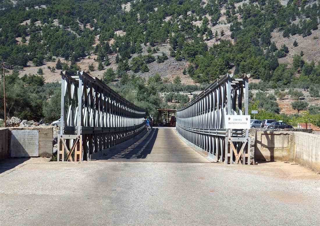
Anopoli opens onto the Aradena gorge to the west, crossed by a high iron Bailey bridge used for bungee jumping; a steep stepped path down to the car-free coastal village of Loutro; the trailhead to Sweetwater beach; and the routes up the White Mountains, including Mount Pachnes.
A car makes the Chania to Anopoli trip flexible, but the bus covers it too. The Chania to Anopoli trip is one of the more rewarding short runs from the city. On a map, Chania to Anopoli traces a clear line that the road follows closely. West of the plateau the ground splits into the Aradena gorge, a deep limestone canyon spanned by a high iron Bailey bridge that vaults the void in one span. The bridge is a bungee-jump platform, and the drop beneath it is one of the tallest bungee sites in Greece. From the bridge and the abandoned village of Aradena a walking route descends through the gorge to the beach at Marmara, where the canyon meets the sea in a cove of smooth rock and clear water. The gorge walk is a hard, rewarding descent that ends at the shore.
South of the village a steep stepped path drops down the mountain face to Loutro, the car-free coastal hamlet that clings to the sea below the plateau. Loutro has no road; it is reached on foot down this path or by boat, and the descent from Anopoli is the classic overland way in. From Loutro the coastal footpath runs east to the Sweetwater beach, known in Greek as Glyka Nera, where cold springs bubble up through the shingle at the waterline \u2014 and a trailhead from the plateau feeds hikers onto this stretch of the south coast.
Behind the village the White Mountains rise to their highest summits. Anopoli is a launch point for the ascent of Mount Pachnes, the loftiest peak of the range and the second-highest in Crete, and for the network of mountain paths that cross the massif to the Samaria country and beyond. The plateau also stands within reach of Chora Sfakion and its ferries to Loutro, Agia Roumeli and the island of Gavdos, and of the Imbros gorge on the road down from the north. Few villages in Crete put so much wild terrain within a single starting point \u2014 a gorge, a bungee bridge, a car-free port, spring-fed beaches and the tallest peaks of the west, all fanning out from one high plateau.
Is the trip to Anopoli worth it, and when to go?
The trip is worth it for the mountain scenery, the Sfakian history and the trailheads to gorges, beaches and peaks. Go from late spring to early autumn, when the mountain road is clear and dry, and drive the crossing in daylight for the views and the safety of the switchbacks.
The Chania to Anopoli drive rewards the effort with the sights at the end of it. Planning Chania to Anopoli around the light and the meals makes the most of the visit. The trip from Chania to Anopoli pairs well with the neighbouring stops on the same road. Anopoli rewards the traveller who wants the real interior of Crete rather than the resort strip. The drive itself is half the experience \u2014 the climb through Askifou and Imbros, the descent to the Libyan Sea, and the switchback ascent to the plateau string together the finest mountain landscapes in the west of the island. At the top wait the quiet hamlets, the taverna lamb, the statue of Daskalogiannis and a horizon of White Mountain peaks. For walkers the plateau is a prize, the single door to the Aradena gorge, the path to Loutro, the Sweetwater shore and the summit of Pachnes.
The season sets the terms. Late spring through early autumn gives warm, dry weather, an open mountain road and long daylight for the drive and the trails. Winter brings snow to the White Mountains and cold, wet spells to the plateau, and the high country turns hostile to the unprepared. Spring paints the upland green and studs it with wildflowers; high summer bakes the coast but keeps the 600-metre plateau cooler than the shore; autumn holds warm seas and thinner crowds. For hiking the gorges and the peaks, the shoulder months of the warm season pair comfortable temperatures with clear paths.
Plan the day with the mountain in mind. Fill the fuel tank before leaving the north coast, carry water for the trails, wear proper footwear for the stepped path to Loutro and the gorge descents, and time the drive so the switchbacks are behind you before dusk. Treat Anopoli as a base rather than a quick stop \u2014 an overnight on the plateau or in Loutro opens the early-morning gorges and the coastal ferries and turns a long drive into a full immersion in Sfakia. Reached with care and given the time it deserves, Anopoli stands among the finest destinations in the whole of western Crete.
Frequently Asked Questions
How do you get from Chania to Anopoli?
From Chania to Anopoli, drive south on the E75/A90 to Vryses, then over the White Mountains through the Askifou plateau toward Chora Sfakion, then the switchback road up to the Anopoli plateau, 75 kilometres in 1.5 to 1.75 hours. The KTEL bus reaches Chora Sfakion; a limited local service climbs to Anopoli.
How far is Anopoli from Chania?
Anopoli lies 75 kilometres south of Chania, on a plateau at 600 metres above Loutro and Chora Sfakion in the Sfakia area of the Chania regional unit. The drive over the mountains from Chania to Anopoli takes 1.5 to 1.75 hours.
Is the trip from Chania to Anopoli worth it?
The trip from Chania to Anopoli rewards visitors with a green mountain plateau ringed by the White Mountains, the history of Daskalogiannis, the Aradena gorge and its high bridge, and paths down to Loutro and Sweetwater. The 75-kilometre mountain drive makes Anopoli a full day or a Sfakia base.