
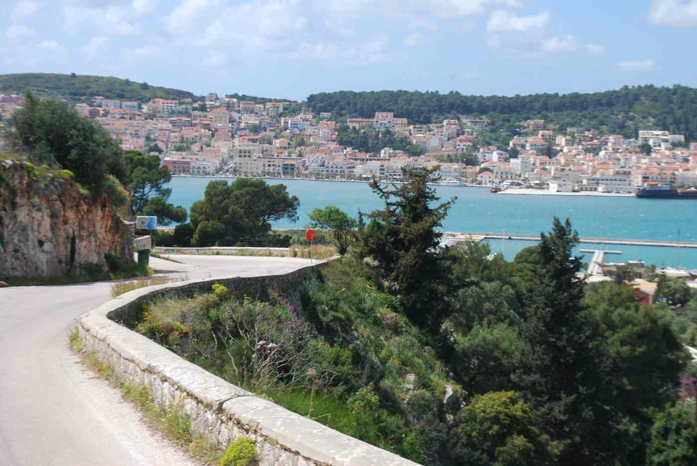
Argostoli is the capital of Kefalonia, the largest of the Ionian Islands, set on a bay in the island’s southwest. A major earthquake flattened the old town, and it was rebuilt low and modern around a shallow lagoon called Koutavos. Today Argostoli mixes an everyday Greek port with a waterfront of cafes, a pedestrian shopping street and a handful of museums. Plan the whole trip with Greece Tours.
This guide covers the heart of Argostoli: its setting on the lagoon, the long De Bosset stone bridge to a lone obelisk. The Katavothres sea mills where the sea sinks into the rock. The loggerhead turtles that feed beside the fishing boats. Each stop lies within a short walk or drive of the central square.
What is Argostoli, and where does it sit on Kefalonia?
Argostoli is the capital and main town of Kefalonia, set on a sheltered bay in the island’s southwest. The low, modern town wraps around a shallow lagoon, rebuilt after the earthquake flattened its older streets.
Argostoli sits on a bay in the southwest corner of Kefalonia, the largest of the Ionian Islands. The town faces a shallow lagoon called Koutavos, ringed by low green hills and a long waterfront promenade. Most streets run flat and straight, the result of a careful rebuild after the town collapsed in the earthquake. Ferries to Lixouri cross the bay in about thirty minutes, while Kefalonia Airport lies around 9 kilometres to the south. The central square, Plateia Valianou, fills with cafes each evening and anchors the daily life of the island’s largest town.
The heart of Argostoli runs along Lithostroto, a marble pedestrian street lined with shops, bakeries and clothing stores. It leads to the central square and the bell tower of the Kambana, a small clock tower rebuilt after the earthquake. The covered municipal market sells local honey, thyme, olive oil and Robola wine from the Omala valley inland. Two museums stand within a short walk: the Korgialenios History and Folklore Museum and the Archaeological Museum. The waterfront, called the Lithostroto quay, carries fishing boats and a line of cafes. Visitors weighing their things to do in Kefalonia often start here.
Argostoli connects easily to the rest of the island and the mainland. Kefalonia Airport sits about 9 kilometres south, near Lassi and the resort beaches of Makris Gialos and Platis Gialos. Buses leave the KTEL station on the waterfront for Sami, Fiskardo, Skala and Poros. The Lixouri ferry crosses the bay through the day, cutting a long road trip around the water to under half an hour. Drivers reach Myrtos beach in about forty minutes and Melissani cave near Sami in roughly thirty. The Kefalonia hub maps these routes across the whole island in detail.
Evening in Argostoli centres on Plateia Valianou, where families gather under plane trees and children play until late. The lagoon path draws walkers and runners along the Koutavos wetland, a protected habitat for birds and eels. Across the water, the small chapel and the Napier Garden give shaded corners away from the waterfront. Argostoli serves as the island’s administrative capital, holding the port authority, the hospital and the main bus network. Most visitors base a day or two here before touring the beaches and caves. The rebuilt low skyline keeps sea views open from nearly every street toward the bay.
What is the De Bosset bridge across the Argostoli lagoon?
The De Bosset bridge, also called the Drapano bridge, is a long stone causeway that crosses the Argostoli lagoon. Built on arches, it carries a footpath to a small stone obelisk standing in the water.
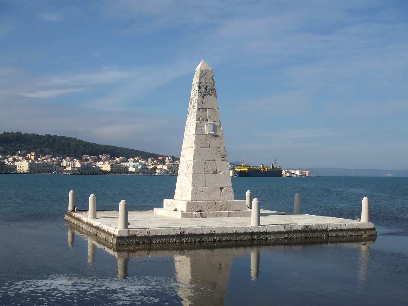
The De Bosset bridge stretches for about 700 metres across the shallow Koutavos lagoon, linking Argostoli to the Drapano side. A Swiss officer in British service, Charles Philippe De Bosset, first built it in wood during the British administration of the Ionian Islands. Stone arches later replaced the timber, and the bridge survived the earthquake that flattened much of the town. Today it carries only walkers and cyclists, closed to cars, so the crossing stays quiet. Halfway along, a small stone obelisk rises from the water, once topped by an inscription. The view back to the waterfront takes in the whole harbour.
The lagoon that the bridge crosses is called Koutavos, a shallow, sheltered inlet at the head of Argostoli bay. Reeds and eelgrass fill its edges, and the water rarely runs deeper than two metres. A flat walking and cycling loop rings the lagoon, about 3 kilometres long, shaded by eucalyptus and pine. Herons, cormorants and the occasional loggerhead turtle feed in the calm water. The bridge and the lagoon together frame the classic view of Argostoli, with the town’s low rooftops behind. Early morning and late afternoon bring the softest light and the coolest air for the walk.
The stone obelisk at the middle of the bridge once marked British rule, its plaque long weathered away. It stands alone in the lagoon, reached only by the footpath, and marks a natural pause point on the crossing. Fishing boats sometimes tie up near the arches, and swans and ducks drift past the base. At sunset, the light behind the obelisk turns the water gold, drawing photographers to the eastern railings. The full walk from the town side to the Drapano end takes about fifteen minutes at an easy pace. Benches along the causeway let walkers rest and watch the birds.
The town end of the bridge sits beside the Koutavos wetland car park, a short walk from the central square. From there, walkers reach the causeway in about two minutes, with no ticket or gate. Loggerhead turtles often surface in the bay just north, near the fishing quay where boats land their catch. The bridge links the two sides of the lagoon that road traffic must otherwise loop around. Cyclists use it as part of a wider ride out to Lassi and the southern beaches. The flat surface and open water make it one of the easiest walks in Argostoli.
What are the Katavothres sea mills near Argostoli?
The Katavothres are sinkholes on the coast just north of Argostoli, where seawater pours into the rock. The current once turned mill wheels; the water travels underground across the island and resurfaces at Melissani cave near Sami.
The Katavothres sit at the tip of the Lassi peninsula, about 2 kilometres north of Argostoli’s centre. Here the sea flows inland into cracks in the limestone, a rare reverse of the usual river-to-sea pattern. A restored waterwheel and a small stone mill house mark the spot, once used to grind grain. A cafe and a short viewing path now stand beside the swirling channels. The flow slowed after the earthquake shifted the rock, but water still drains steadily into the ground. Signboards explain how the sinkholes work, and the site sits an easy ten-minute drive from the town square.
The water that vanishes at the Katavothres crosses beneath Kefalonia to the east coast. A dye poured into the sinkholes reappeared days later at Melissani cave and the Karavomylos spring near Sami, about 15 kilometres away. This proved that a hidden underground river runs through the island’s soluble rock. Melissani is a collapsed cavern holding a blue lake, reached by a short boat ride under an open roof. The same system feeds the Karavomylos lake beside the sea at Sami. The link ties Argostoli’s quiet mills to one of the island’s most visited caves across the mountains.
A visit to the Katavothres takes about thirty minutes on foot around the channels and the mill. The rebuilt wheel turns slowly where the sea still runs into the rock, easy to watch from the railings. The nearby Agioi Theodoroi lighthouse, a round white rotunda ringed by columns, stands a short walk further along the point. Sunset draws crowds to this stretch of coast, with the open Ionian Sea to the west. The whole headland lies within walking distance of Lassi’s hotels and the beaches of Makris Gialos. Parking sits beside the cafe, and the path stays flat throughout.
The Katavothres form part of a wider karst system that shapes Kefalonia’s rivers and caves. Rain sinks quickly through the limestone, so streams rarely run above ground on the island. The sinkholes near Argostoli are the clearest place to see this water disappear at the coast. From the town, a half-day trip can link the Katavothres, the lighthouse and the Lassi beaches in one loop. Drivers heading east to Sami can trace the same underground water to Melissani and Drogarati caves. The mills give Argostoli a natural landmark that ties the capital to the geology of the whole island.
Where can you see loggerhead sea turtles in Argostoli?
Loggerhead sea turtles gather in Argostoli’s harbour, near the fishing quay where boats clean their catch. The turtles feed on the scraps thrown into the water, surfacing close to the waterfront through the morning.
The loggerhead sea turtle, Caretta caretta, is a protected species that nests on Ionian beaches. In Argostoli, the turtles gather in the sheltered harbour beside the fishing boats, drawn by fish scraps in the water. Mornings bring the best sightings, when boats return and clean their catch along the Lithostroto quay. The turtles surface for air about two metres from the railings, easy to watch from the promenade. Adults can measure about a metre long and weigh up to 100 kilograms. The calm, shallow water of the bay makes Argostoli one of the simplest places in Greece to see them.
The turtles come into the harbour to feed, not to nest, so they appear year-round but peak in summer. Conservation groups on Kefalonia, including local sea-turtle projects, monitor the harbour animals and record injuries from boats. Signs along the quay ask visitors not to feed, touch or chase the turtles in the water. Fishing boats naturally draw them in when discarded fish fall from the nets at the dock. The clear water lets watchers follow a turtle’s slow path between the moored hulls. Nesting itself happens on southern beaches such as Mounda, near Skala, where volunteers guard the eggs.
The best spot to watch the turtles runs along the northern waterfront, near the KTEL bus station and the fish market. From the railings, watchers look straight down into water two to three metres deep. Early morning, between the boats’ return and mid-day, brings the most turtles to the surface. A slow walk along the quay usually turns up two or three animals feeding near the hulls. Polarised sunglasses cut the glare and make the turtles easier to follow underwater. Keeping quiet and still at the edge lets them surface close without being scared back down into the harbour.
The harbour turtles turn a working fishing quay into one of Argostoli’s steady draws for visitors. Watching them costs nothing and fits between a walk on the De Bosset bridge and a drive to the Katavothres. The same protected animals nest on Kefalonia’s southern sands and feed across the Ionian Sea each summer. Their presence reflects the clean, sheltered water of the bay and the daily rhythm of the fishing fleet. A short stop at the quay rounds out a morning in the capital before the beaches of Lassi. Respecting the distance keeps the turtles wild and the harbour a safe feeding ground.
What will you find at Plateia Valianou and the Lithostroto in Argostoli?
Plateia Valianou is the main square of Argostoli, ringed by cafes, while the Lithostroto is the marble-paved pedestrian shopping street a short walk downhill. Both sit in the town centre near the waterfront.
Plateia Valianou anchors the centre of Argostoli, a broad open square lined with cafes and tavernas that fill with tables in the evening. The square carries a statue and monuments to local figures, and it stays busy after dark when families walk the loop. From the square, Argostoli’s grid slopes down toward the harbour in about a five-minute walk. The town rebuilt this centre on a low, wide plan after the earthquake, which flattened most of the old houses. Benches, plane trees and the surrounding arcades give the square shade through the summer heat.
The Lithostroto runs as a marble-paved pedestrian street through the shopping heart of Argostoli, a short walk from Plateia Valianou. Shops here sell clothing, jewellery, local Robola wine and food, and the paving reflects the light in the late afternoon. The Catholic church of Saint Nicholas and the bell tower of Agios Spyridon stand along or just off the street. The paving is smooth stone, easy to walk in sandals, and the street stays free of cars. Most of the retail trade of the town concentrates on this stretch and the lanes that branch off it toward the sea.
The waterfront of Argostoli lies about 300 metres downhill from Plateia Valianou, where the town meets the lagoon and the fishing boats tie up. Evening life moves between the square and this seafront promenade, with the passenger jetty for the Lixouri ferry set along the same shore. The centre packs its cafes, banks and services into a walkable grid that measures only about 400 metres across. Cruise passengers who dock in the bay reach the square on foot within ten minutes. The compact layout means most visitors staying in town cover the centre without any transport.
Plateia Valianou and the Lithostroto together form the social core that Argostoli rebuilt after the earthquake levelled the old town. The square handles the evening crowd, while the Lithostroto handles daytime shopping, and the two connect by a two-minute walk. Street numbering stays simple, and signs point from the square toward the museums and the harbour. The centre stays lively from spring through October, then quiets in winter when most cafes shorten their hours. Argostoli holds roughly 10,000 residents, which keeps the town busy through the year rather than emptying like the smaller Kefalonia villages inland.
Which museums can you visit in Argostoli?
Argostoli holds two main museums: the Archaeological Museum, with finds from across Kefalonia, and the Korgialenios History and Folklore Museum, which records island life before the earthquake. Both stand in the town centre within a short walk.
The Archaeological Museum of Argostoli displays finds from prehistoric, Mycenaean and Roman Kefalonia, gathered from sites across the island. Exhibits include pottery, coins, bronze work and grave goods that trace settlement from the Bronze Age onward. The museum sits in the town centre, a short walk from Plateia Valianou, and covers the whole island rather than one period. The collection suffered damage in the earthquake and was later reinstalled, so the display today is a rebuilt sequence. The building is compact, and most visitors cover the rooms in about an hour before continuing to the folklore museum nearby.
The Korgialenios History and Folklore Museum records everyday Kefalonian life in the century before the earthquake destroyed the old town. Displays include furniture, costumes, lace, tools, household objects and photographs of Argostoli as it stood before the collapse. The museum sits below the Korgialenios Library in the centre, close to the Archaeological Museum. Rooms are arranged to show middle-class and rural interiors, so the visit reads as a walk through vanished houses. The photographs carry particular weight, since they preserve streets and buildings that the earthquake erased and the town never rebuilt in the same form.
Both museums stand within about a five-minute walk of each other in the centre of Argostoli, so visitors often pair them in one morning. The Archaeological Museum leans toward ancient Kefalonia, while the Korgialenios covers the recent past, and together they frame the island’s full timeline. Opening hours run mainly in the morning and early afternoon, and both tend to close on one weekday, so checking ahead helps. Entry is charged per museum rather than as a single ticket. The two sit close to Plateia Valianou and the Lithostroto, which lets visitors combine museums, shopping and a meal on the same short loop.
The two museums give Argostoli its cultural anchor, since the earthquake destroyed most physical traces of the old town. The Korgialenios in particular acts as the town’s memory, holding images and objects that outlasted the buildings themselves. School groups and researchers use both collections, and labels appear in Greek and English. Neither museum is large, so they suit a half-day rather than a full day, leaving time for the Lithostroto or the waterfront. Visitors who want the fuller island story pair these two museums with a walk along the Lithostroto and the waterfront, all inside the walkable centre of Argostoli.
What are Lassi, Makris Gialos and Platis Gialos near Argostoli?
Lassi is the main resort area just southwest of Argostoli, about 3 km from the centre, lined with hotels and tavernas. Its two sandy beaches, Makris Gialos and Platis Gialos, sit side by side on the coast below.
Lassi spreads along the coast road just southwest of Argostoli, about 3 km from Plateia Valianou, and forms the busiest accommodation base near the capital. Hotels, apartments, tavernas and mini-markets line the road, and visitors comparing where to stay in Kefalonia often pick Lassi for its beaches and quick access to town. The area faces west, so it catches the sunset over the sea toward the Lixouri peninsula. A local bus and a steady stream of taxis connect Lassi with the centre of Argostoli in about ten minutes. The resort stays walkable, with the beaches reached on foot from most of its lodgings.
Makris Gialos is a sandy beach below Lassi, about 3 km from the centre of Argostoli, set in a small bay with clear shallow water. The sand is soft and pale, the slope into the sea is gentle, and sunbeds, umbrellas and beach bars run along the back. Low headlands split the shore into linked coves, which keeps the water calm on most days. The beach faces southwest, so the afternoon and sunset light fall directly on the sand. Its combination of soft sand and easy access from town makes Makris Gialos one of the busiest beaches close to Argostoli.
Platis Gialos lies just south of Makris Gialos, a second sandy beach separated only by a rocky point, also about 3 km from Argostoli. The two beaches share the same soft sand and clear water, and a short walk or a low path links them along the shore. Sunbeds, umbrellas and a beach bar serve Platis Gialos, and the bay stays sheltered from the north wind. Swimmers rank both among the best-known Kefalonia beaches within reach of the capital, ahead of the longer drive to Myrtos or Antisamos. The compact scale of the pair suits families based in Lassi or in Argostoli itself.
Lassi and its two beaches give Argostoli a seaside quarter within about 3 km of the square, so visitors reach sand without leaving the capital’s orbit. The coast road from town runs southwest along the shore before dropping to the Lassi hotels and the beach access points. Makris Gialos and Platis Gialos both face southwest, which gives them long afternoon sun and sheltered water. The mix of resort services and quick access to the museums and Lithostroto makes Lassi a practical base for a first visit to Kefalonia. Families, couples and cruise passengers use these beaches most, since the drive from the centre stays under fifteen minutes.
How do you get around from Argostoli?
Kefalonia Airport (EFL) sits about 9 km south of Argostoli, and a short ferry crosses the bay to Lixouri. Buses run on limited routes, so most visitors rent a car to reach beaches and villages.
Kefalonia Airport (EFL) lies about 9 km south of Argostoli, a drive of roughly fifteen minutes by taxi or car. The airport handles seasonal charter and scheduled flights in summer, with fewer connections in winter, and full details on how to get to Kefalonia cover both the flights and the ferry routes. Taxis wait outside the terminal, and most car-hire firms keep desks at the airport for pickup on arrival. No regular public bus links the terminal directly with Argostoli, so a taxi or a rental car covers the transfer. The road runs north past Lassi into the centre of the capital.
A small car-and-passenger ferry crosses the bay between Argostoli and Lixouri, the second town on the Paliki peninsula opposite. The crossing takes about 20 to 30 minutes and runs about hourly in summer, cutting out the 30 km road route around the bay. The Argostoli jetty sits on the waterfront below Plateia Valianou, so foot passengers board straight from the town centre. Lixouri gives access to Xi beach, with its red-orange sand, and to Petani on the far side of the peninsula. Visitors often ride the ferry across for an afternoon and return by boat rather than driving the long way.
Buses on Kefalonia run from the KTEL station on the Argostoli waterfront, with routes to Sami, Fiskardo, Skala, Poros and Lixouri. Frequencies stay low, often one to three departures a day on each route, and services thin out sharply after summer. The network suits set trips between the main towns rather than reaching remote beaches like Myrtos, which sit off the bus lines. Timetables cluster around the morning and early afternoon, so a day trip by bus needs planning around the return. Buses cost little, but the limited schedule pushes most visitors toward a rental car for freedom across the island.
A rental car gives the most freedom from Argostoli, since the island stretches about 50 km north to Fiskardo and the famous beaches sit off the bus routes. Roads are paved but winding through the mountains, and the drive to Myrtos or Fiskardo takes over an hour each way from the capital. Car-hire desks operate at the airport and along the Argostoli and Lassi waterfronts, and booking ahead in peak summer secures a vehicle. Fuel stations cluster around Argostoli, Sami and Lixouri, with fewer in the far north, so filling up before long drives helps. Parking in Argostoli works best in the marked bays near the waterfront and the square.
Frequently Asked Questions
Is Argostoli worth staying in on Kefalonia?
Argostoli works well as a base, since it combines the island’s main services with quick access to beaches and ferries. The capital sits about 9 km from Kefalonia Airport and holds the widest choice of hotels, cafes, banks and shops on the island. Plateia Valianou and the Lithostroto give an evening scene on foot, while the Lassi resort and the beaches of Makris Gialos and Platis Gialos lie about 3 km southwest. Buses to Sami, Fiskardo and Skala leave from the town waterfront, and the Lixouri ferry crosses the bay from the centre. The main trade-off is distance: Myrtos, Assos and Fiskardo sit over an hour away by road in the north.
First-time visitors who want museums, dining and central transport usually prefer Argostoli, while those chasing the famous northern beaches often split their stay between the capital and the north.
How far is Argostoli from Kefalonia Airport?
Kefalonia Airport (EFL) sits about 9 km south of Argostoli, a drive of roughly fifteen minutes. The road runs north from the terminal, passing close to the Lassi resort before reaching the town centre. Taxis wait outside the arrivals hall and cover the transfer directly to Argostoli or Lassi. Car-hire firms keep desks at the airport, so visitors often collect a rental on arrival and drive straight to their accommodation. No regular public bus connects the terminal with the capital, which leaves a taxi or a rental car as the practical choices. The airport handles mostly seasonal flights, busiest between late spring and early autumn, with far fewer arrivals in winter.
The short, direct road keeps the airport transfer one of the easiest parts of reaching Argostoli, even in peak summer traffic.
Can you walk around Argostoli town centre?
Argostoli’s centre is compact and flat, so walking covers most of it within about ten minutes end to end. Plateia Valianou, the main square, sits a two-minute walk from the Lithostroto, the marble-paved pedestrian shopping street. The waterfront lies roughly 300 metres downhill from the square, and the Archaeological and Korgialenios museums stand within the same walkable grid. The town rebuilt on a low, wide plan after the earthquake, which gave it broad, level streets that suit walking. Cars use the outer roads and the seafront, but the shopping core stays pedestrian and calm. Cruise passengers who dock in the bay reach the square and the Lithostroto on foot in about ten minutes.
For beaches and outlying villages a car or bus is needed, yet the daily business of Argostoli itself works entirely on foot from a central base.
What beaches are closest to Argostoli?
Makris Gialos and Platis Gialos are the closest beaches to Argostoli, both about 3 km southwest below the Lassi resort. The two share soft pale sand, clear shallow water and a gentle slope into the sea, and a short path links them along the shore. Sunbeds, umbrellas and beach bars serve both bays, and their southwest aspect brings long afternoon sun. The pair sit within a ten-minute drive of Plateia Valianou, or a short local bus and taxi ride from town. Farther afield, the famous northern beaches of Myrtos, Assos and Emblisi lie over an hour away by road, while Antisamos near Sami takes about 45 minutes.
For a first swim close to the capital, Makris Gialos and Platis Gialos are the practical choice, with Lassi’s services right behind the sand.
How do you get from Argostoli to Lixouri?
A short car-and-passenger ferry links Argostoli with Lixouri, crossing the bay in about 20 to 30 minutes. The jetty sits on the Argostoli waterfront below Plateia Valianou, so foot passengers board straight from the town centre. Boats run about hourly through the summer day, with fewer sailings in winter, and carry both cars and walk-on passengers. The ferry saves the 30 km road route that loops around the head of the bay, a drive of roughly 45 minutes. Lixouri is the second town on the island, set on the Paliki peninsula, and gives access to Xi beach with its red-orange sand and to Petani. Visitors often cross for a half-day, walk the Lixouri seafront and return by boat.
The crossing turns a long drive into a quick hop and connects the two sides of Argostoli’s bay.
Do you need a car in Argostoli?
A car is not needed inside Argostoli, but it helps for exploring the rest of Kefalonia. The town centre, the Lassi resort and the beaches of Makris Gialos and Platis Gialos all sit within about 3 km and connect by foot, local bus or taxi. Beyond that ring, the bus network runs only one to three times a day to Sami, Fiskardo and Skala, and skips remote beaches like Myrtos. Car-hire desks operate at the airport, about 9 km south, and along the Argostoli and Lassi waterfronts, with booking advised in peak summer. A rental opens the winding mountain roads to Myrtos, Assos, Fiskardo and the Melissani cave, each over an hour from the capital.
For a stay based only in town and its nearby beaches, walking and the Lixouri ferry cover most days without a car.