
Aradena Gorge stands among the most dramatic canyons in south-west Crete, a deep rocky cleft that drops from the abandoned stone village of Aradena down to the coast at Marmara beach. The route rewards walkers who want raw mountain scenery, sheer limestone walls and a real sense of solitude away from crowded trails. A tall steel bridge spans the ravine high above the floor, a landmark that doubles as a bungee-jump platform. This guide gathers the practical detail you need before you lace your boots, from the terrain and the water supply to the coastal links, so you can plan the descent with confidence with My Greece Tours.
Aradena sits within the Sfakia mountains, one of the wildest corners of the island and a region shaped by dry-stone terraces and shepherd paths. The sections below cover the terrain of the descent, the famous bridge, the finish at Marmara beach, the boat and footpath links along the shore, and how this ravine compares with busier routes. Read it alongside our wider Crete travel guide for context on where the canyon fits within the island. The answers stay concrete so you can judge the walk against your own fitness and time.
Where does Aradena Gorge sit in Crete?
Aradena Gorge lies in the Sfakia region of south-west Crete, cutting from the abandoned stone village of Aradena down to the coast at Marmara beach near Loutro, deep within the island’s rugged southern mountains and cliffs.
The gorge opens directly below the deserted village of Aradena, a cluster of roofless stone houses perched on the plateau edge above the ravine. Walkers reach the trailhead beside the tall steel bridge, then drop into the canyon on old stone steps and loose scree that shifts constantly underfoot with each careful step. The terrain rewards planning, and pairing the descent with other things to do in Crete in the same corner of the coast helps you build a full day rather than a single rushed walk on hard, exposed ground.
The wider Sfakia region frames the whole route, a rugged landscape of dry-stone terraces, grazing goats and steep footpaths that shepherds have used for generations across these remote southern slopes high above the deep blue Libyan Sea.
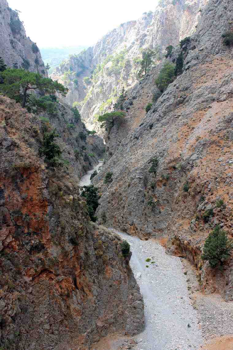
The canyon runs roughly north to south, funnelling walkers from the high inland plateau toward the Libyan Sea. Sheer limestone walls rise on both sides, narrowing in places to a shaded corridor before opening again onto sun-baked rock and dry-stone dividers. The floor holds boulders, old field walls and worn stone stairways that mark the ancient path down to the water. The descent ends at pebbly Marmara beach, where clear water and a seasonal taverna reward the effort of the morning.
This southern flank of the island stays far drier than the greener north coast, so the light is fierce and the shade is scarce for long stretches of the walk, a factor that shapes exactly when you should set out from the high bridge above the ravine.
What is the Aradena bridge and gorge terrain like?
A tall steel bridge spans the ravine high above the canyon floor, ranking among the tallest in Greece and serving as a bungee-jump platform. The hike then descends over loose rock and old stone steps between sheer walls.
The bridge is the signature sight of the whole route, a slender steel span crossing the ravine far above the dry riverbed on the plateau. It counts among the tallest bridges in Greece and draws bungee jumpers who leap from the deck into the void below. Walkers often pause on the span to look straight down the throat of the canyon before starting the long descent. The structure replaced an older crossing and now links the plateau to the trailhead on the far side of the drop.
Standing on the deck gives a rare overhead view of the gorge that you cannot get from anywhere along the floor, a striking introduction to the sheer scale of the ravine and the drop you are about to walk into.
The terrain underfoot is demanding from the very first step of the day. The path drops over loose rock, scree and old stone steps that thread between sheer walls and dry-stone terraces on the way down. Short stretches force you to scramble across fallen boulders, using your hands to steady the descent over the awkward ground. Sturdy boots with firm grip matter, and twisted ankles are the main risk on the shifting surface below. Shade is scarce, so the heat builds fast on exposed rock through the middle of the day. Carry two litres of water per person, since no reliable source runs along the route in the dry months.
The floor stays dry through the walking season, yet flash flooding can strike after heavy rain, so check the forecast before you commit to the descent.
How does the Aradena hike in Crete end at the coast?
The descent ends at pebbly Marmara beach, where clear water meets sheer rock and a seasonal taverna serves walkers. The Crete coastline here offers a swim and rest before you continue along the shore path toward Loutro.
Marmara beach marks the mouth of the gorge, a pebbly cove hemmed by low cliffs pocked with sea caves and worn hollows. The water runs clear and deep close to shore, ideal for a cooling swim after the hot, rocky descent from the bridge. A seasonal taverna sits above the pebbles, serving cold drinks and simple food through the warm walking months. Walkers linger here to rest tired legs before the next leg of the journey along the coast toward the villages. The cove faces the Libyan Sea, so the afternoon light glows warm on the rock and water.
Nearby Loutro makes a natural base, a road-free village reached only by boat or footpath, where whitewashed houses ring a sheltered bay and tavernas line the water’s edge.
The finish rewards the effort with genuine calm, since the cove draws far fewer visitors than the island’s headline beaches on the north coast. Committed walkers treat Marmara as one stage in a longer coastal push, and threading the gorge into a broader plan for hiking in Crete lets you chain it with neighbouring trails along the wild south shore. Boats run seasonally from the cove, sparing weary legs the steep uphill return to the plateau. The pebbles heat up under the midday sun, so water shoes ease the walk down to the shoreline and into the sea.
Time your arrival for early afternoon and you can swim, eat and still catch a boat onward before the light fades over the Libyan Sea and the taverna winds down for the evening.
Can you reach Loutro and Agia Roumeli from the gorge?
From Marmara a coastal path and seasonal boats connect to Loutro and Agia Roumeli, linking the gorge into the wider south-coast trail network. Walkers combine the ravine with village stops rather than retracing the steep climb.
The coastal footpath west of Marmara hugs the cliffs toward Loutro, a rugged trail of rock steps and narrow ledges above the sea. Seasonal boats cover the same stretch for walkers who prefer to save their legs after the demanding descent through the gorge. Loutro serves as the hub of this shore, a car-free village where every arrival comes by boat or on foot along the coast. Onward boats run to Agia Roumeli, the coastal settlement at the foot of the famous Samaria Gorge, letting you stitch two contrasting canyon walks into one south-coast itinerary across the region.
This chain of villages and trails turns a single gorge descent into a rewarding multi-day route along one of the least developed and most peaceful coastlines on the whole island.
Planning the links matters, since boat times shift with the season and the weather can cancel sailings on exposed days. Check the schedule the evening before and keep a footpath backup in mind for the return leg. The trail between Marmara and Loutro takes roughly one hour at a steady walking pace, following the rugged shoreline the whole way. Water and sun protection stay essential, because the coastal path offers little shade beyond the odd tamarisk tree. Reaching Agia Roumeli opens the option of the Samaria descent on a separate day, or a boat onward to Sougia and Paleochora further west along the coast.
This connected network is what makes Sfakia so rewarding, repaying walkers who plan their days around the boats rather than racing a single trail to its finish.
How does Aradena Gorge in Crete compare to Samaria?
Aradena stays far quieter than the famous Samaria route, drawing walkers who want solitude and raw mountain scenery. The Crete canyon is shorter and rockier, with no ranger gates or crowds, yet demands surer footing on loose ground.
Samaria draws large crowds through the walking season, a long ranger-managed trail with a set entry point, marked rest stops and a steady stream of walkers all day. Aradena offers the opposite mood, an unmanaged ravine where you may pass barely another walker all morning on the descent. The quieter Imbros Gorge nearby sits between the two in scale and traffic, a gentler option for walkers easing into rugged Sfakia terrain before the harder route down. Aradena rewards experience and sure feet, since the loose rock and the boulder scrambles ask far more of the body than a groomed, well-marked trail.
The trade-off is genuine solitude and a raw sense of the wild mountains that the busier, managed route simply cannot offer through the crowded peak summer months.
The two gorges suit different walkers, and the choice comes down to what you want from the day out. Samaria delivers a long, celebrated route with the reassurance of rangers, water points and a clear finish at Agia Roumeli on the coast. Aradena delivers wildness, silence and a steel bridge that no other Cretan gorge can match, at the cost of harder ground and no support along the way. Pair Aradena with the quiet coastal villages and you gain a route that feels remote yet stays reachable by seasonal boat.
Choose it on a clear, settled day, start early to beat the heat, and the ravine repays the effort with scenery that lingers long after your tired legs recover from the rocky descent to the sparkling sea.
Frequently Asked Questions
How long and hard is the Aradena Gorge hike?
The descent runs a short but demanding course from the bridge trailhead down to Marmara beach, taking most walkers two to three hours at a careful pace. The difficulty comes from the surface rather than the distance, since the path drops over loose rock, scree and old stone steps that shift underfoot the whole way. Short sections need hands-on scrambling across fallen boulders between the sheer walls of the ravine. Sturdy boots with firm grip matter, and trekking poles help steady the knees on the constant downhill gradient. Shade is scarce, so the heat builds fast on the exposed limestone through the middle of the day.
Carry two litres of water per person, because no reliable source runs along the ravine in the dry months. Start early to beat the fierce southern sun, and treat the walk as a genuine mountain hike rather than a casual stroll along a flat, groomed trail.
Which season suits the Aradena Gorge walk best?
Late spring and early autumn offer the kindest conditions, with milder temperatures and a lower flash-flood risk than the wetter winter months. The summer heat turns the exposed rock brutal by midday, so an early start becomes essential for anyone walking in the peak season. Winter rain can send water down the dry floor and make the loose rock treacherous, so the coldest months carry real hazard for walkers. Check the forecast the evening before, since heavy rain upstream can trigger flash flooding even on a clear, bright morning at the coast. The seasonal taverna at Marmara and the coastal boats run through the warmer walking months, then wind down as the season closes for winter.
Aim for a settled, dry spell, set out soon after dawn, and you gain cool air, safer footing underfoot and the best chance of a swim and a hot meal at the finish by the sea.
What should I bring for the Sfakia canyon descent?
Sturdy hiking boots with firm grip top the list, since the loose rock and old stone steps punish weak footwear and thin worn soles. Carry at least two litres of water per person, because no reliable source runs along the ravine and shade is scarce on the exposed limestone floor. Sun protection matters as much as water, so pack a hat, sunglasses and high-factor cream for the fierce southern light. Trekking poles ease the constant downhill on tired knees, and a compact first-aid kit covers scrapes from the boulder scrambles. Bring cash for the seasonal taverna and any boat fare, since card machines stay unreliable on this remote stretch of coast.
Water shoes help on the pebbly beach and for a swim at the finish of the walk. Pack light but complete, keep a charged phone for emergencies, and check boat times before you commit to the descent so the return leg stays covered.