
Ikaria is a Greek island in the eastern Aegean Sea, set apart in the stretch of water that carries its name, the Icarian Sea. The island belongs to the North Aegean region and rests between the Cyclades to the west and the eastern Aegean islands to the east. It sits just west of Samos and beside the small Fourni archipelago, a cluster of islets on its eastern flank. Ikaria is long, narrow and mountainous, running roughly east to west across the sea. The island lies about 250 kilometres east of Athens and its port of Piraeus. This guide maps its exact position and the routes that connect it, prepared with My Greece Tours.
The name Ikaria comes from the myth of Icarus, the boy whose wax wings melted near these waters. The island keeps two ferry ports, Agios Kirykos in the south and Evdilos in the north, and a small airport near the southern harbour. This page anchors the wider Ikaria travel guide and pins down the geography that shapes every trip. The sections below cover where the island sits in the Aegean, its shape and size, its distance from Athens and neighbouring islands, the ferry and flight routes that reach it, and how to orient yourself once you land at either port.
Where is Ikaria located in the Aegean Sea?
Ikaria sits in the eastern Aegean Sea, within the North Aegean region of Greece. It lies west of Samos, beside the Fourni islets, and marks the boundary between the Cyclades to the west and the eastern Aegean islands.
Ikaria occupies a distinct patch of open water known as the Icarian Sea, a name drawn straight from the island itself. This body of sea stretches between the Cyclades and the eastern Aegean chain, and Ikaria stands as its central landmark. Samos rises to the east across a narrow channel, and the Fourni archipelago scatters its small islets just off Ikaria’s eastern shore. Mykonos and the wider Cyclades lie to the west. The island’s position places it on historic sailing lines that once linked Athens with Asia Minor.
Travellers planning routes will find the practical steps in our page on how to get to Ikaria, which sets out every connection from the mainland and the surrounding islands in clear order.
The North Aegean region groups Ikaria with Samos, Chios, Lesvos and Limnos, though Ikaria keeps a character of its own. Its remote setting kept it apart from busy tourist lanes for generations, and that isolation shaped its slow pace and long-lived residents. The surrounding waters run deep and open, exposed to the meltemi wind that sweeps the Aegean in summer. Ferries and flights both cross this exposed stretch, which explains why schedules can shift with the weather. The island faces the mainland to the west and the Turkish coast to the east across Samos.
Anyone charting a first visit gains from studying this layout early, since Ikaria’s placement decides which ports and airports serve as sensible gateways to reach it.
What shape and size is the island of Ikaria?
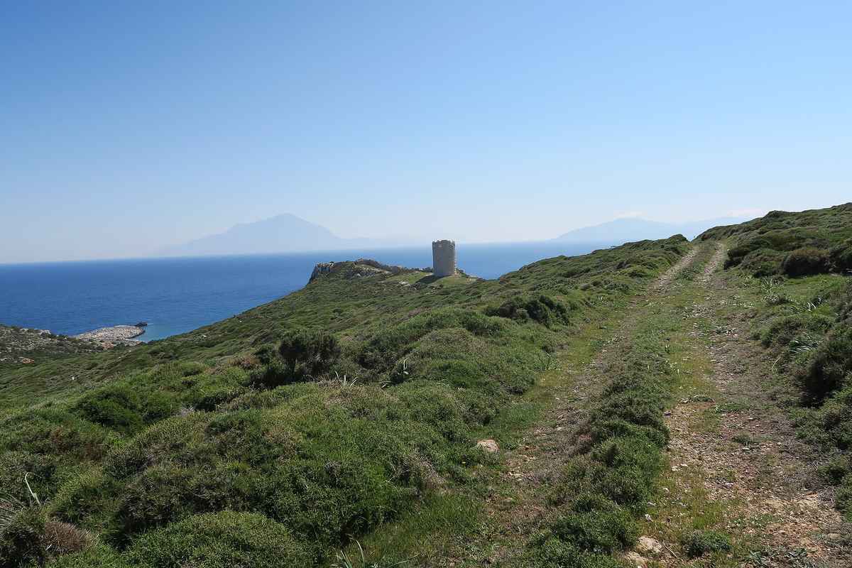
Ikaria is long, narrow and mountainous, stretching roughly east to west across the Icarian Sea. A steep central ridge, the Atheras range, runs the length of the island, splitting a rugged northern coast from a gentler south.
The island measures around forty kilometres in length and stays narrow throughout, rarely more than a dozen kilometres wide. This elongated form gives Ikaria a spine of mountains that dominates its interior. The Atheras range climbs above a thousand metres and divides the island into two clear faces. The northern side falls steeply toward the sea, holding villages such as Evdilos and Armenistis along a coast of pine and rock. The southern side, anchored by Agios Kirykos, slopes more gently and catches the warmer light. This split terrain means a road journey across Ikaria climbs and descends sharply.
Visitors weighing beaches, hot springs and mountain trails can browse the full range in our guide to things to do in Ikaria, which maps activities to each side of the ridge.
The rugged layout explains why Ikaria feels larger than its size suggests. Roads wind around granite outcrops and deep ravines, so short map distances can take real time to cover. Villages perch on slopes rather than spreading across plains, and settlements cluster near the two ports and along the northern coastal strip. The interior holds forests of oak and pine, along with the scattered stone houses of the Rachi districts built to stay hidden from old sea raids. This shape shaped the island’s history and its habits. Beaches sit in coves rather than long open bays, and the best-known stretches lie along the north near Armenistis.
Understanding the east-to-west form helps a visitor plan a base, since crossing from one end to the other is a genuine drive rather than a quick hop.
How far is Ikaria from Athens and other islands?
Ikaria lies roughly 250 kilometres east of Athens and Piraeus by sea. Samos sits just to the east across a short channel, the Fourni islets lie a few kilometres off the eastern coast, and the Cyclades spread to the west.
The distance from Athens frames every travel plan for Ikaria. The island sits about 250 kilometres from Piraeus, the main port serving the capital, which places it well out in the eastern Aegean. This gap means the sea crossing takes time, while the air route covers the same ground in under an hour. Samos, the nearest large neighbour, lies close to the east, linked by short local ferry runs. The Fourni archipelago floats just off Ikaria’s eastern shore and connects by brief boat hops. Mykonos and the Cyclades sit to the west along the ferry line back toward Athens.
Travellers comparing the sea option often start with the Piraeus to Ikaria ferry, the backbone route that ties the island to the mainland.
Distance to the smaller neighbours matters for island-hopping plans. Boats from Ikaria reach Fourni in well under an hour, making the tiny archipelago an easy day out. Samos connects by regular crossings that open a gateway toward the eastern Aegean and the Dodecanese beyond. The westbound ferry line threads back through Mykonos and Syros before it returns to Piraeus, so a route from Athens can weave through the Cyclades on the way. Patmos and the northern Dodecanese lie within reach through the same network of local links. These sea distances explain why Ikaria pairs naturally with Samos or Fourni for a combined trip.
A traveller who grasps the spacing early can build a loop that folds the neighbours into one itinerary rather than treating Ikaria as an isolated stop.
How do you reach Ikaria by ferry and flight?
Reach Ikaria by ferry from Piraeus, a crossing of about seven to ten hours, or by a domestic flight from Athens lasting around forty-five minutes. Ferries dock at Agios Kirykos or Evdilos; flights land near Agios Kirykos.
The ferry is the traditional way to arrive and the most flexible for carrying a car. Boats leave Piraeus and cross the Aegean in roughly seven to ten hours, with the exact time set by the vessel and the ports it calls at along the way. The route often stops at Cycladic islands before it reaches Ikaria, which stretches the journey but opens island-hopping options. Some services run overnight, letting a traveller sleep through the crossing and land fresh at dawn. Our full breakdown of how to get to Ikaria lists the seasonal patterns, while the dedicated page on flights covers the faster route.
Both ports, Agios Kirykos and Evdilos, receive ferries, so a traveller should confirm which harbour a booked boat serves before setting out.
The flight cuts the mainland journey to under an hour. A domestic service from Athens covers the distance in around forty-five minutes and lands at the small airport near Agios Kirykos on the southern coast. Seats stay limited on the compact aircraft that fly the route, so early booking pays off in the busy season. Travellers weighing the trade-off between speed and cost can compare fares and schedules through our page on flights to Ikaria, which sets the air option beside the sea crossing. The airport sits close to the southern port, which makes onward transfers straightforward.
A visitor choosing the flight lands in the south and then decides whether to base there or cross the ridge to the northern coast, a choice shaped by the island’s east-to-west form.
How do you get oriented when you arrive on Ikaria?
Ikaria has two ferry ports: Agios Kirykos in the south and Evdilos in the north. The airport sits near Agios Kirykos. The southern side holds the capital and hot springs; the north holds the main beaches and resort villages.
Arrival on Ikaria begins at one of two harbours, and knowing the difference shapes the first day. Agios Kirykos, the island capital, anchors the south. It holds the port authority, the nearby airport and the famous radioactive hot springs at Therma just along the coast. The southern side leans quieter and administrative, a good base for the springs and the eastern reach toward Fourni. Evdilos serves the north and sits closer to the beach country around Armenistis and the forest of Randi. A traveller landing here reaches the swimming coves and the lively summer villages with a shorter drive.
The choice of port often decides the shape of a stay, so it helps to plan the base before booking the crossing that appears in our Piraeus to Ikaria ferry guidance.
The ridge between north and south means a transfer across the island is a real journey. Roads climb from either port over the Atheras range and down the far slope, a drive of around an hour that rewards travellers with wide sea views. Local buses run but keep sparse schedules, so a rental car or a pre-booked transfer eases movement between the two coasts. The north draws sun-seekers to Armenistis, Nas and the pine-backed beaches, while the south suits those after the springs and a slower rhythm. First-time visitors gain from matching their arrival port to their plans.
Our overview of things to do in Ikaria pairs each region with its highlights, which makes the north-versus-south decision clear before a boat or plane is booked.
Frequently Asked Questions
Where exactly is Ikaria?
Ikaria is a Greek island in the eastern Aegean Sea, within the North Aegean region. It sits in the Icarian Sea, the stretch of water named after the island, between the Cyclades to the west and the eastern Aegean islands to the east. The island lies just west of Samos, separated by a short channel, and beside the small Fourni archipelago that scatters off its eastern shore. Ikaria stands about 250 kilometres east of Athens and its port of Piraeus, well out toward the Turkish coast. The land runs long, narrow and mountainous from east to west, split by a central ridge.
Its two ferry ports mark the ends of that spine: Agios Kirykos in the south and Evdilos in the north. The island’s open, exposed setting kept it remote for centuries, and that position still governs which ferry and flight routes serve it today.
How far is Ikaria from Athens?
Ikaria lies roughly 250 kilometres east of Athens by sea, placing it well into the eastern Aegean. The ferry from Piraeus, the port that serves the capital, crosses this distance in about seven to ten hours, with the exact time set by the vessel and the ports it calls at along the way. A faster option exists in the air: a domestic flight from Athens covers the same ground in around forty-five minutes and lands at the small airport near Agios Kirykos in the south. The sea route often threads through Cycladic islands such as Mykonos and Syros before it reaches Ikaria, which stretches the journey but opens island-hopping choices.
The wide gap from the mainland explains why Ikaria feels genuinely remote compared with islands closer to Piraeus. Travellers weigh the slow, flexible ferry against the quick flight based on budget, timing and whether they plan to bring a car.
Which islands are near Ikaria?
Samos is the closest large neighbour, sitting just east of Ikaria across a short channel and linked by regular local ferries. The small Fourni archipelago floats a few kilometres off Ikaria’s eastern shore and connects by brief boat hops, making it an easy day trip. To the west lie the Cyclades, with Mykonos and Syros falling along the ferry line that runs back toward Athens and Piraeus. Patmos and the northern Dodecanese sit within reach through the eastern Aegean network, often via Samos. This spread of neighbours makes Ikaria a natural anchor for a combined trip, since Fourni and Samos both pair easily with a stay on the island.
The westbound route through the Cyclades lets travellers fold Ikaria into a wider loop from Athens. Grasping which islands lie near helps a visitor build an itinerary that treats Ikaria as part of a chain rather than an isolated stop.