
Thermopylae tours start at the pass in Phthiotis, Central Greece, between Mount Kallidromo and the Malian Gulf, where Leonidas and the Greek army held the Persians in 480 BC. The routes cover the Leonidas monument, the Kolonos hill, the hot springs that gave the pass its name and the later battles fought on the same ground. Greece Tours lists the day tours that reach Thermopylae from Athens.
This page covers what Thermopylae tours see at the monuments and the springs, the history of the battles, the Alamana bridge, Lamia, Mount Oeta and the trips on to Delphi, Meteora and Marathon, how visitors reach Thermopylae, which season suits each route and the local food. The tours below are checked on GetYourGuide and leave from Athens.
What do Thermopylae tours cover?
Thermopylae tours cover the historic pass in Phthiotis, Central Greece, between Mount Kallidromo and the Malian Gulf. The stops are the Leonidas monument, the Thespian monument, Kolonos hill and the Thermopylae Historical Information Centre, all inside the Municipality of Lamia.
The name Thermopylae means “hot gates”, after the hot sulphur springs of the area. The pass is the only land route between Lokris and Thessaly wide enough for heavy traffic. The A1 motorway between Athens and Thessaloniki now follows the ancient shoreline and splits the pass.
The village of Thermopylae stands 30 metres above sea level on the north-western foothills of Mount Kallidromo. It lies 17 km south-east of Lamia, the seat of the municipality. Lamia lies 206 km from Athens. Thermopylae tours that start in the capital run as a Thermopylae day trip from Athens.
- Region: the regional unit of Phthiotis, in the region of Central Greece.
- Municipality: Lamia, formed on 1 January 2011 under the Kallikratis programme.
- Local community: Thermopylae, made up of the village and Loutra Thermopylon, inside the municipal unit of Lamia.
- Mountain: Kallidromo, 1,399 metres high, south of the pass.
- Old village name: Drakospilia, changed to Thermopyles in 1955.
The four stops of Thermopylae tours sit close together. The information centre stands near the Leonidas monument. The monument faces Kolonos hill across the road.
What do Thermopylae tours see at the Leonidas monument?
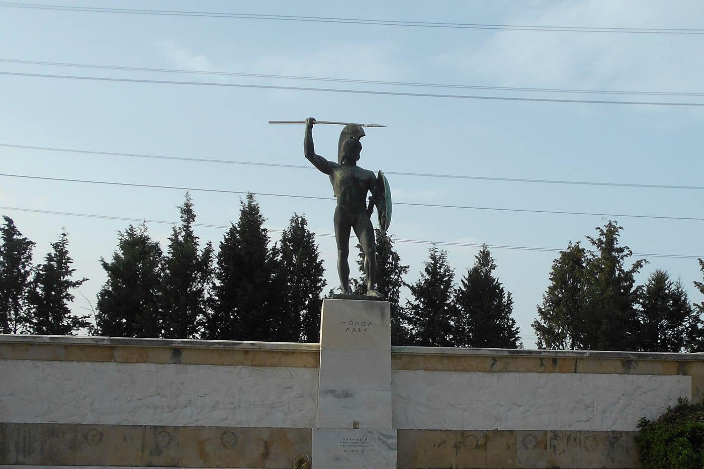
Thermopylae tours see a bronze statue of King Leonidas I of Sparta, erected in 1955 by the sculptor Vassos Falireas. The words ΜΟΛΩΝ ΛΑΒΕ, “come and take them”, stand under the statue. The Thespian monument of 1997 stands beside it.
Thermopylae tours find the monument at the centre of the pass, where the final phase of the battle of 480 BC took place. Greeks living in America paid for it and first planned it for Sparta, but objections there sent it to Thermopylae.
Falireas modelled the figure on the marble “Leonidas” torso found on the acropolis of Sparta in 1925. The bronze king holds a spear and a shield. ΜΟΛΩΝ ΛΑΒΕ was the reply of Leonidas when Xerxes offered to spare the Spartans if they gave up their arms. A metope below the statue shows battle scenes. Two marble statues flank the monument: the river Eurotas on the left and Mount Taygetos on the right, both landmarks of Sparta.
Thermopylae tours also stop at the Thespian monument next to it. The Greek government unveiled it in 1997 for the 700 Thespians who fought beside the Spartans under their general Demophilus. It is made of marble and carries a bronze statue of the god Eros. A sign under the figure reads “In memory of the seven hundred Thespians”. A plate explains its symbols.
- Headless male figure: the anonymous sacrifice of the 700 Thespians.
- Outstretched chest: struggle, strength and courage.
- Open wing: victory, glory and freedom.
- Broken wing: voluntary sacrifice and death.
- Naked body: Eros, the chief god of the ancient Thespians.
A second bronze Leonidas by Falireas has stood in Sparta since 1969. Thermopylae tours see the earlier statue.
What do Thermopylae tours see on the Kolonos hill?
Thermopylae tours see Kolonos hill, the low hill opposite the Leonidas monument and the site of the final stand of the 300 Spartans in 480 BC. A stone on the summit, set up in 1955, carries the epigram traditionally attributed to Simonides of Ceos.
The epigram is an elegiac couplet, a form common on Greek epitaphs. The Greek text reads “Ὦ ξεῖν’, ἀγγέλλειν Λακεδαιμονίοις ὅτι τῇδε κείμεθα, τοῖς κείνων ῥήμασι πειθόμενοι”. In English, it asks the stranger to tell the Lacedaemonians that the dead lie here, obedient to their words. The verse plays on the idea that nobody was left to carry the news to Sparta. Thermopylae tours read it from the top of the hill.
The original stone has not survived. According to Herodotus, the fallen were buried on the spot, and a stone lion and three plain monuments stood in their honour. In 1939 the archaeologist Spyridon Marinatos found large numbers of Persian bronze arrowheads on the hill. The find moved the identification of the last-stand site from a smaller hill nearer the wall to Kolonos.
- Position: opposite the Leonidas monument, at the centre of the pass.
- Later remains: fortification works of different periods, Roman and Byzantine graves and ruins of Byzantine buildings, found in the 1939 dig.
- Spearheads: iron and bronze spearheads of the 5th century BC, found at the foot of the hill.
- Wall of the Phocians: built in the 6th century BC and used by the Spartans in the battle; its remains near the hill are hard to recognise and closed to the public.
Thermopylae tours see a hill whose shape has changed since antiquity, because later builders added defensive works on it. A Ministry of Culture and Sports project with the Municipality of Lamia covers the restoration of the Phocian wall and walking paths to the monument and the centre.
What do Thermopylae tours see at the Thermopylae Historical Information Centre?
Thermopylae tours see three halls at the Thermopylae Historical Information Centre, near the Leonidas monument: an introductory video, a 3D film of the battle watched through special glasses, and eight touch screens on the Persian Wars. The Municipality of Lamia opened the centre in August 2010.
The centre opened during the Thermopylaia celebrations, with European Union funding. Thermopylae tours enter an 878-square-metre building shaped like a spearhead, pointed towards the side from which the Persians entered the pass. The centre explains the battle and the topography, because geological change has hidden the narrows and the battlefield. The ancient ground now lies under 20 metres of soil.
The Foundation of the Hellenic World curated the 3D film and the content of the touch screens. The material draws on the history of Herodotus and on archaeological research. It addresses every age group, from preschool children to older adults. Thermopylae tours use the halls to picture the narrow pass of 480 BC.
- Leonidas hall: a lecture room that doubles as the waiting area, with an introductory video.
- Dienekes hall: named after a Spartan of the battle; a 15-minute 3D film shows the arms of the Greeks and the Persians, the climb up the Anopaia path and Ephialtes leading the Persians at night to Kolonos hill.
- Thermopylae hall: touch screens on the Ionian Revolt and Marathon, the three days at Thermopylae, the naval battle of Artemisium, and the aftermath at Salamis and Plataea.
- Legacy screen: the impact of the battle on sculpture, painting, poetry and literature.
The Municipality of Lamia also offers virtual tours of 3D digital models of Thermopylae. Its guided routes on smart mobile devices focus on the historical triangle of Thermopylae, Alamana and Gorgopotamos.
What history of the battle of 480 BC do Thermopylae tours tell?
Thermopylae tours tell how King Leonidas of Sparta led a Greek force of about 7,000 men against the Persian army of Xerxes in 480 BC. The Greeks blocked the pass for two full days, until a mountain path let the Persians reach their rear.
The story on Thermopylae tours starts in Sparta during the Carneia, a festival when Spartan law forbade military action. Leonidas marched north with 300 Spartans, and contingents from other cities joined on the road. When Xerxes demanded the Greek weapons, Leonidas replied “Molon labe”, or “come and take them”.
On the first day Medes and Cissians attacked, then the Immortals, an elite corps of 10,000 men, and both waves failed to break the Greeks. The second day ended the same way. Later that day Ephialtes of Trachis told Xerxes about the mountain path in return for a reward, and his name came to mean “nightmare” in Greek. That evening Hydarnes led the Immortals along the ridge of Mount Anopaea, behind the cliffs that flank the pass.
On the third day Leonidas sent the bulk of the army away and stayed to cover the retreat. He fell to Persian archers, and the Greeks fought over his body and took it. The last defenders held a hill behind the wall until Persian arrows killed every man. In 1939 the archaeologist Spyridon Marinatos found Persian bronze arrowheads on Kolonos Hill, and Thermopylae tours point to it as the hill of the last stand.
- Xerxes: Persian king whose army modern scholars put at 120,000 to 300,000 soldiers.
- Spartans: the 300 Hippeis of the royal bodyguard, each a father with a living son.
- Thespians: 700 hoplites under Demophilus, the whole hoplite force of their city.
- Thebans: 400 men who surrendered; the prisoners were branded with the royal mark.
Which later battles do Thermopylae tours cover?
Thermopylae tours cover the later battles fought at and around the pass: the Gallic attack under Brennus in 279 BC, the Roman victory over Antiochus III in 191 BC, the stand of Athanasios Diakos at Alamana in 1821 and the ANZAC rearguard of 1941.
Thermopylae tours begin the later history in 279 BC, when Aetolians, Boeotians, Athenians, Phocians and Locrians held the pass against the Gauls of Brennus. Brennus found a way around the pass, and the Athenian fleet carried the Greeks away by sea. He was defeated at Delphi, and the Thessalians and Malians routed his army at the river Spercheios.
On 24 April 191 BC the consul Manius Acilius Glabrio attacked Antiochus III the Great, who held the pass behind a wall and ditch. The Seleucids threw back the frontal assaults until Marcus Porcius Cato surprised the 600 Aetolians of Fort Callidromus and struck the Seleucid camp from the hillside. The Seleucid army broke, and Antiochus escaped with his cavalry.
On 22 April 1821 Athanasios Diakos held the bridge at Alamana against an Ottoman army of 8,000 under Omer Vrioni and Köse Mehmed. He stayed with 48 men, was captured after his sword broke and was impaled on Vrioni’s order. On 24–25 April 1941 New Zealand and Australian brigades held Thermopylae and Brallos, destroyed 15 German tanks and withdrew by midnight. Thermopylae tours note that this line stood metres from the battlefield of 480 BC.
- 279 BC: the Gauls outflank the pass and the defenders leave on Athenian ships.
- 191 BC: Cato takes Fort Callidromus and the Seleucid line collapses.
- 1821: Diakos and 48 men fight hand to hand for hours at the Alamana bridge.
- 1941: the delay allows the evacuation of the British expeditionary force to Crete.
What do Thermopylae tours see at the hot springs?
Thermopylae tours see the hot sulphur springs that gave the pass its name, which means “hot gates”. The water still rises at the foot of the hill, 16 km south-east of Lamia, and leaves the rock at a temperature of 40 °C.
For Thermopylae tours, the springs carry the myths of the place. One version of the labours of Heracles says the water turned hot when he tried to wash off the poison of the Hydra there. A Greek version says Hephaestus made the spring at the request of Athena, for Heracles to wash in after his labours. The site was also linked with an entrance to Hades.
The springs also shaped the battles told on Thermopylae tours. Herodotus reports that the Phocians channelled the stream from the springs into a marsh, crossed by a causeway only wide enough for one chariot. In 191 BC the Roman army of Glabrio camped at the “hot gates”, halfway through the pass. Travertine from the springs has also altered the landscape over thousands of years.
Work to organise the springs began in 1935, and the hydrotherapy centre dates from the 1930s. The Greek list of spas records that the thermal facilities have since closed and that the water is used freely where it leaves the rocks.
- Name: Thermopylae means “hot gates”, after the hot sulphur springs.
- Location: Loutra Thermopylon, beside the village of Thermopylae on its west side.
- Water type: hyperthermal, hypotonic and weakly radioactive.
- Chemistry: chloride, sodium, potassium, hydrosulphide, bromide and carbon dioxide.
How has the coast seen on Thermopylae tours changed since antiquity?
Thermopylae tours stand kilometres inland at a pass where the sea reached the gates in 480 BC. Silt from the Spercheios river pushed the shore of the Malian Gulf forward by as much as 9 km, and the battle ground lies under 20 metres of soil.
Core samples show that the pass was only 100 metres wide in 480 BC, with the gulf on one side and steep hills on the other. The Malian Gulf stood higher in prehistoric times, and the Spercheios was shorter. Between 2500 BC and 480 BC the shoreline had already advanced by up to 2 km.
The Spercheios explains the landscape seen on Thermopylae tours. It enters the Malian Gulf 13 km south-east of Lamia, and its silt has turned Thermopylae from a narrow pass into a wide plain. The former wetlands along the river have been reclaimed for agriculture.
The old track runs at the foot of the hills beside a modern road, and the A1 motorway between Athens and Thessaloniki follows the ancient shoreline through the pass. Thermopylae lies in Phthiotis, on the east coast of central Greece, so Thermopylae tours belong to the wider group of Central Greece tours.
- Width in 480 BC: 100 metres, with the water up to the gates.
- Width in 191 BC: about 90 metres at the eastern end of the pass.
- Shoreline since 480 BC: up to 9 km further out in places.
- Spercheios: 80 km long, rising in the Tymfristos mountains and draining 1,830 km².
Which Thermopylae tours visit the Alamana bridge and the Athanasios Diakos monument?
Thermopylae tours that cover the Greek War of Independence stop at the Alamana bridge, which crosses the Spercheios 3 km west of Thermopylae. Athanasios Diakos made his last stand there in April 1821, and a monument to him stands at the bridge.
The Spercheios once carried the name Alamana, a name now tied to the battle. In 1821 the road to Thermopylae passed this bridge. Diakos, Dimitrios Panourgias and Yiannis Dyovouniotis chose the line to halt the Ottoman advance into Roumeli. They split 1,500 fighters into three groups: Dyovouniotis held the Gorgopotamos bridge, Panourgias held the heights of Halkomata, and Diakos held the Alamana bridge.
The army of Omer Vrioni and Köse Mehmed set out from its camp at Lianokladi, near Lamia. The other two Greek groups fell back, and the attack turned on the bridge. Diakos stayed with 48 men and fought hand to hand for hours. He was captured after his sword broke and taken to Lamia, then called Zitouni. Vrioni offered him an officer’s rank. Diakos replied, “I was born a Greek and I will die a Greek.” He was impaled the next day.
A monument now stands at the bridge near Alamana. The Municipality of Lamia also lists a Diakos Memorial along the National Highway, built in honour of the battle. Thermopylae tours reach it from the Old Lamia–Athens Highway: the municipal directions run toward Thermopylae, then left to Alamana. The stand of Diakos echoed the defence of the Spartan king Leonidas, so Thermopylae tours tell both stories on the same day.
- Bridge: a crossing of the Spercheios, 3 km west of Thermopylae.
- Defenders: Diakos and 48 men held the bridge until his capture.
- Monument: at the bridge, with a Diakos Memorial on the National Highway.
- Name: Diakos means deacon; he was ordained a Greek Orthodox deacon before he became a klepht.
What do Thermopylae tours see in Lamia?
Thermopylae tours that stop in Lamia see the castle on its rocky hill, the Archaeological Museum inside the castle walls and the city squares. The village of Thermopylae lies 17 km south-east of Lamia, the capital of Phthiotis and of Central Greece.
Lamia sits on the slopes of Mount Othrys, near the Spercheios. In antiquity it controlled the narrow coastal plain above Thermopylae, the link between southern Greece and Thessaly. The old Athens–Thessaloniki national road runs through both places, and Thermopylae tours cover the 17 km on that road.
Lamia Castle crowns a rocky hill that controls the Spercheios valley as far as the Malian Gulf. Its walls form a triangle with a 600-metre perimeter and rise to 13 metres at the north-west corner. The south-east “iron gate” joined the castle to the lower town. Excavations inside the walls show settlement since the Bronze Age. The Archaeological Museum of Lamia fills the first floor of the barracks on the castle plateau. The barracks date from the reign of King Otto and served the army until the Second World War. The museum opened on 25 September 1994.
Diakou Square, west of Parkou Square, holds the statue of Athanasios Diakos, placed there in 1903. Diakos died in Lamia after the battle at Alamana, so Thermopylae tours that follow the 1821 story end it in this square. Eleftherias Square hosts the independence day parade and the main cathedral. Laou Square holds the statue of Aris Velouchiotis.
- Distance: 17 km between Lamia and the village of Thermopylae.
- Castle: triangular walls, 1.35 m thick on average, with two gates.
- Museum: first floor of the Othonian barracks, opened in 1994.
- Squares: Eleftherias, Diakou, Parkou and Laou.
Which Thermopylae tours continue to Delphi?
Thermopylae tours that continue to Delphi take the national road from Thermopylae to Bralos, then the EO27 to Amfissa. Delphi lies 20 km from Amfissa, on the south-west slope of Mount Parnassus, and UNESCO lists its sanctuary as a World Heritage Site.
The first leg of Thermopylae tours to Delphi follows the Thermopylae–Antirrio National Road, whose eastern part runs between Thermopylae and Bralos. The national road register treats it as an extension of the EO27, the road that links Lamia with Amfissa. Amfissa sits between Mount Giona and Mount Parnassus, 72 km south of Lamia. Delphi lies on the EO48 between Amfissa in the west and Livadeia in the east.
Thermopylae tours that pair the two sites follow an old tie. The sanctuary of Demeter at ancient Anthele, south of modern Anthili, was an early centre of the Delphic Amphictyony. The Amphictyonic League took control of Delphi in the early Classical period and protected the Temple of Apollo.
At Delphi, Thermopylae tours add the seat of the Pythia, the oracle consulted across the ancient Greek world. The ancient Greeks placed the centre of the world here and marked it with the Omphalos stone. The theatre above the Temple of Apollo held about 4,500 spectators. The museum shows the Charioteer of Delphi, the Sphinx of Naxos and the earliest known notation of a melody. The full story of the sanctuary sits on the Delphi page.
- First leg: Thermopylae to Bralos on the Thermopylae–Antirrio National Road.
- Second leg: the EO27 to Amfissa, 72 km south of Lamia.
- Last leg: 20 km from Amfissa to Delphi on the EO48.
- Shared past: Anthele, near Thermopylae, served as an early centre of the Delphic Amphictyony.
Which Thermopylae tours continue to Meteora?
Thermopylae tours that continue to Meteora join the A3 motorway near Anthili, 8 km south-east of Lamia, and cross western Thessaly to Trikala and Kalabaka. Meteora lies 21.94 km from Trikala, and its six monasteries stand on the UNESCO World Heritage List.
Thermopylae tours bound for Meteora pick up the A3, also called the Central Greece Motorway, which branches off the A1 near Anthili and meets the A2 near Grevena. It runs 181 km and serves the towns of western Thessaly. Its middle section, an 80 km stretch between Xyniada and Trikala, opened first. The final section links Kalabaka with Grevena.
Meteora stands between the town of Kalabaka and the village of Kastraki, at the north-west edge of the Plain of Thessaly near the Pineios river and the Pindus Mountains. The rock pillars are a mix of sandstone and conglomerate. Twenty-four monasteries rose on top of them, mainly from the second half of the 14th century, and six survive. The Great Meteoron dates from 1356, and Varlaam stands above a 373-metre cliff.
The day takes Thermopylae tours from the coastal pass to the rock towers of Thessaly. Locally, the Meteora complex ranks second in importance only to Mount Athos. More on the monasteries and the rocks sits on the Meteora page.
- Motorway: the A3, 181 km, from the A1 near Anthili to the A2 near Grevena.
- Last leg: 21.94 km from Trikala to Meteora.
- Monasteries: 24 founded, six still standing.
- UNESCO: on the World Heritage List since 1988.
Which Thermopylae tours combine Marathon?
Thermopylae tours that combine Marathon link two battlefields of the Persian Wars. Athens and Plataea defeated a Persian force sent by Darius I at Marathon in 490 BC, and the second Persian invasion, under his son Xerxes I, reached Thermopylae in 480 BC.
The fleet of Datis and Artaphernes landed in the bay of Marathon. Miltiades and the Athenians, with 1,000 hoplites from Plataea, closed the two exits from the plain. Herodotus puts the dead at 6,400 Persians and 192 Athenians.
Thermopylae tours read the two sites as one story. Lightly armoured Persian infantry was no match for Greek hoplites head-on, as Thermopylae and Plataea later showed. Sparta missed Marathon: the Carneia festival kept its army at home, and the Spartans arrived the day after the battle, after a march of 220 km in three days.
On the road, Thermopylae tours start at the Soros, the burial mound of the 192 Athenians, marked by a marble stele. The A1 motorway between Athens and Thessaloniki then runs north past Kamena Vourla, 175 km from Athens, to the village of Thermopylae, 25 km further west.
- First invasion: 490 BC, a sea expedition sent to punish Athens and Eretria.
- Second invasion: 480 BC, with early Persian success at Thermopylae and Artemisium.
- Marathon: about 40 km from Athens, between Mount Penteli and Mount Parnitha.
- Thermopylae: a lowland village 17 km southeast of Lamia, 30 m above sea level.
Full-day Marathon tours cover the plain and its museums, while Thermopylae tours make it the first stop of the day.
What do Thermopylae tours see at Kamena Vourla and the Malian Gulf?
Thermopylae tours see Kamena Vourla, a spa town on the south coast of the Malian Gulf, 25 km east of the village of Thermopylae. The town grew around radon-rich springs, and the slopes of the Knimis mountains rise straight behind its seafront.
The name Kamena Vourla means “burnt rushes”. The springs gained fame around 1926, when the chemist Michail Pertesis measured an exceptionally high radon content in the water. The first hotels followed in the 1930s, and after the Second World War the town became a tourist resort.
Thermopylae tours that climb inland reach the Monastery of the Transfiguration of the Saviour, 8 km uphill and dated to the 11th century. On the seafront, the parish church of Agios Panteleimon holds its feast on 27 July.
The Malian Gulf takes its name from the ancient Malians, who lived on its shores. It reaches 15 to 22 km inland, with a maximum depth of 27 m, and Stylida, the port of Lamia, is its only harbour. Under the London Protocol of 1830, a line from the gulf to the Aspropotamos River became the northern border of the new Greek state.
- Cape Knimis: 4 km east of the town, between the Malian Gulf and the North Euboean Gulf.
- Silt: deposits from the Spercheios and smaller streams keep shrinking the gulf.
- Tsunami: a wave struck the gulf in the summer of 426 BC.
- Motorway: the road curve around the gulf is called the Horseshoe of Maliakos.
Thermopylae tours that stop at Kamena Vourla pair the battlefield with the springs and the seafront.
What do Thermopylae tours see at Mount Oeta and the Gorgopotamos bridge?
Thermopylae tours see the railway viaduct over the Gorgopotamos river, which Greek partisans and British saboteurs blew up on 25 November 1942, and the slopes of Mount Oeta, a 2,152 m offshoot of the Pindus range and a national park since 1966.
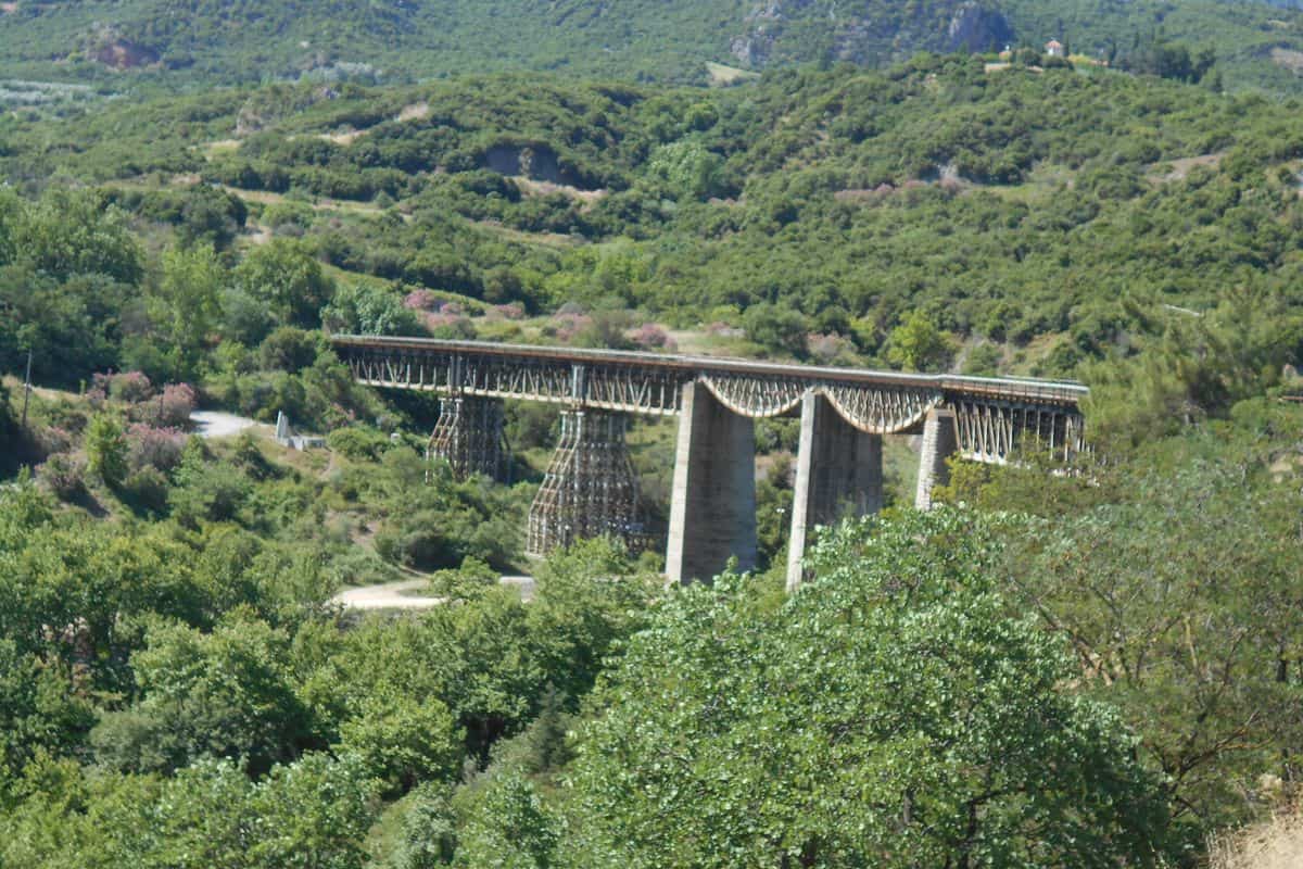
Thermopylae tours stop at the bridge, built in 1905 to a design by Agostino Tacconi. It carries the Athens–Thessaloniki railway near the village of Gorgopotamos, 8 km southwest of Lamia. In Operation Harling, 150 men struck it: 12 British saboteurs of the Special Operations Executive under Eddie Myers, 86 ELAS fighters and 52 EDES fighters.
The guard of 80 Italians held out longer than planned. The first charge went off at 01:30, wrecking the central pier and dropping two spans. The raid ranks among the first major sabotage acts in occupied Europe, and German documents called it “the recent sabotage near Thermopylae”. The Germans executed 16 local people in reprisal.
Thermopylae tours that go higher reach Mount Oeta, on the border of Phocis and Phthiotis. Its national park covers 7,000 hectares, the third largest in Greece, with 1,149 recorded plant species and the Balkan chamois as its symbol. The Kremastos waterfall counts as the highest in Central Greece. In myth, Heracles died on a pyre on Oeta, and the remains of a 3rd-century BC Doric temple and of his pyre survive at 1,800 m, near Pavliani.
- Peaks: Pyrgos at 2,152 m and Greveno at 2,117 m.
- Rivers: the Gorgopotamos and Asopos flow east and the Vistriza west, all into the Spercheios.
- Memorial: the bridge area is a national monument, and since 1982 the anniversary of the raid marks the national day of the Resistance.
Which Thermopylae tours visit Ypati and the Spercheios valley?
Thermopylae tours that visit Ypati drive 30 km west to a village on the north slopes of Mount Oeta, 400 m above sea level, facing the Spercheios valley. The stops are the medieval castle, the Byzantine Museum of Phthiotis and the old spa of Loutra Ypatis.
Ypati began at the turn of the 5th and 4th centuries BC as Hypata, capital of the Aenianes, and in Roman times it ranked as the chief city of Thessaly. As Neopatras, it served as capital of the Greek principality of Thessaly from 1268 to 1318 and of the Catalan Duchy of Neopatras from 1319 to 1391.
The castle still dominates the town and, after restoration with EU funds, opened to the public on 19 December 2015. The Byzantine Museum of Phthiotis fills a barracks of 1836 and shows finds from across Phthiotis, from early Christian to late Byzantine times. Thermopylae tours also pass the Church of Hagia Sophia and the monument to the 28 people executed on 17 June 1944.
Herodotus records the hot springs 3 km northwest of the town, today Loutra Ypatis, a spa village at 85 m just south of the Spercheios. The river runs 80 km from the Tymfristos mountains, passes Makrakomi and Leianokladi, and meets the Malian Gulf 13 km southeast of Lamia.
- Agathonos Monastery: 15th century, 3 km west of Ypati, with the Oiti Natural History Museum inside.
- Natura 2000: the valley, the river mouth and the Malian Gulf form a protected area of 463.27 square kilometres.
- River god: the Iliad names the Spercheios as the father of Menesthius, a lieutenant of Achilles.
Thermopylae tours that end in Ypati cover the valley from the foot of Oeta to the river mouth.
How do Thermopylae tours reach the site from Athens?
Thermopylae tours from Athens follow the A1 motorway, the principal north–south road connection in Greece. Lamia lies 206 km from Athens, and the modern village of Thermopyles sits 17 km southeast of Lamia. Intercity trains stop at Leianokladi, and KTEL buses serve Lamia.
The A1 is the second-longest motorway in Greece, at 557 km, and it joins Athens with Thessaloniki. North of the pass, the motorway bypasses Lamia to the southeast. Its exit list includes a Thermopyles exit, and the A1 runs to the northwest of the village. The old Athens–Thessaloniki national road crosses the south side of the settlement, so Thermopylae tours by car or coach have two road approaches.
Rail travel uses the Athens–Thessaloniki main line. Leianokladi station stands at the junction of that line with the branch to Lamia and Stylida, and intercity trains between Athens and Thessaloniki call there. The Leianokladi–Stylida line, known as the Lamia Suburban Railway, covers its route in 33 minutes and stops at Lamia station, which has a taxi rank in the forecourt.
Buses in the area run under KTEL, a cooperation of regional bus companies. An intercity KTEL station in Lamia handles routes to and from the city. Lamia also has an urban KTEL service, and its city taxis are red.
- Road: the A1 north from Athens, with a Thermopyles exit beside the village.
- Rail: an intercity train to Leianokladi, then the branch line into Lamia.
- Bus: a KTEL coach to the intercity bus station in Lamia.
- Distance: Lamia 206 km from Athens, Thermopyles 17 km southeast of Lamia.
When do Thermopylae tours run best?
Thermopylae tours run best in spring and autumn. At nearby Lamia, April averages a high of 21.1 °C and October 23.6 °C, while July peaks at 33.7 °C. The warm, moderately dry season lasts from mid-April to late October.
Lamia has a hot-summer Mediterranean climate, Köppen type Csa, with four distinct seasons. The figures come from the weather station at Lamia airport, 143.4 m above sea level. August averages a high of 33.4 °C, and July collects 312.3 hours of sunshine, so Thermopylae tours in July and August face the peak heat of the year.
Spring and autumn sit between the extremes. Average highs reach 26.7 °C in late spring and 29.2 °C in September. Rain returns with the cold, wet period from late October to mid-April, and November is the wettest month, with 73.2 mm.
Winter days stay cool. January averages a high of 12.3 °C and a low of 3.0 °C, and December logs 87.1 hours of sunshine, the lowest monthly total of the year. On the coast, data from the National Observatory of Athens station at Stylida, 17 km east of Lamia, indicate a hot semi-arid climate, Köppen type BSh, with mild winters and very hot summers.
- Spring: April brings 10.6 rain days and an average low of 8.8 °C.
- Summer: July records 21.1 mm of rain over 3.8 rain days.
- Autumn: October rain reaches 65.4 mm over 10.4 rain days.
- Winter: December lows average 4.6 °C, with 13.5 rain days.
What local food do Thermopylae tours taste in Phthiotis?
Thermopylae tours cross the farmland of Phthiotis, a regional unit with 5,530,000 olive trees and 70 olive mills. Its farm products include olives, PDO pistachios, rice from the Spercheios Delta and durum wheat, the main cereal of the area.
Olive growing and pistachio growing lead the tree crops of Phthiotis. Olives also cover 35.40% of the 37,309 stremmata farmed organically by 573 growers. One theory links Zitouni, the medieval name of Lamia, to Zeitun, a Turkish or Arabic word for olive.
The pistachio variety of Makri, a village near the Spercheios river, holds PDO status, and Makri has grown pistachios widely since the early 1950s. Rice farming dominates the Spercheios Delta around Anthili and Roditsa and dates from about 1950. The delta wetland covers 196 km², and its larger part is arable land under rice. The A1 passes the western edge of Anthili, a farming town 8 km southeast of Lamia, so Thermopylae tours from the north drive past the delta farmland.
Durum wheat leads the cereal harvest, and small pasta factories, flour mills and rice mills operate in the regional unit. Lamia itself serves as the agricultural centre of a fertile rural and livestock area. Its bazaar opened by 1658 and drew trade from across Greece and the Balkans.
- Pistachios: grown in western Phthiotis and around Molos and Locris.
- Rice: paddies around Anthili and Roditsa in the Spercheios Delta.
- Tomatoes: industrial tomatoes from Domokos, processed at Xyniada.
- Tree crops: almonds, apples, walnuts and chestnuts beside the olive groves.
Frequently Asked Questions
How far do Thermopylae tours travel from Thessaloniki?
Thermopylae tours from Thessaloniki cover 298 km to Lamia, the capital of Phthiotis. The A1 links the two cities, and intercity trains between Thessaloniki and Athens stop at Leianokladi, where every passenger train connects with the branch line into the centre of Lamia. The Athens–Thessaloniki line is double-track and electrified along its entire length.
Which airports connect to Thermopylae tours?
Thermopylae tours have no airport at Lamia, because Lamia Airport belongs to the Air Force and has no commercial or passenger traffic. The A1 links to Athens Eleftherios Venizelos Airport through the A6 motorway, to Nea Anchialos through National Road 30 and to Thessaloniki Macedonia Airport through the A2 and the A24.
What temperature records frame Thermopylae tours?
Thermopylae tours take place in a climate with wide extremes. Lamia recorded its highest temperature, 46.5 °C, in the summer of 1973, and its lowest, −12.6 °C, in December 2001. June averages a high of 31.8 °C, and its 50.2% humidity is the lowest monthly figure of the year.
Which seafood do Thermopylae tours find in Phthiotis?
Thermopylae tours reach a coast with 435 coastal fishing boats, based mainly at Agia Marina, Stylida, Larymna, Agia Triada, Kamena Vourla and Karavomylos. The average yearly catch reaches 2,500 tonnes of fish and 700 tonnes of shellfish, mainly kydonia, and the shellfish farms of the area cluster in the Malian Gulf.
How do KTEL buses serve Thermopylae tours?
Thermopylae tours by bus use KTEL, the main intercity bus service of Greece, founded in 1952 as a cooperation of 62 regional bus companies. The intercity KTEL of Phthiotis serves the Lamia bus station, and KTEL companies together carry 80% of all passenger transport in Greece.