
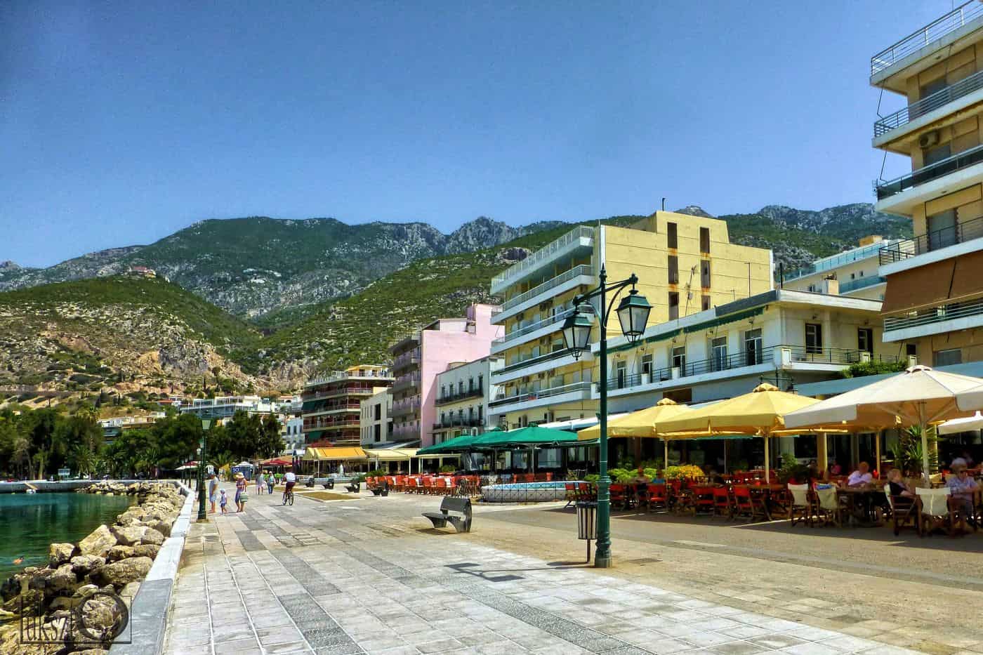
Loutraki tours start in a spa town on the Gulf of Corinth, 81 km west of Athens, at the foot of the Geraneia mountains. The routes cover the thermal springs, the lagoon of Vouliagmeni, the sanctuary of Hera at Perachora, the Corinth Canal and the story of the town from ancient Thermae to today. Greece Tours lists the boat, kayak and day tours that start in Loutraki.
This page covers what Loutraki tours see at the springs, the lake, the Heraion and the canal, the history of the town, the beaches, the day trips, how visitors reach Loutraki and which season suits each route. The tours below are checked on GetYourGuide and leave from Loutraki and Athens.
What do Loutraki tours cover?
Loutraki tours cover a spa town on the Gulf of Corinth, 81 km west of Athens, with its thermal springs, the lagoon of Vouliagmeni, the sanctuary of Hera at Perachora, the Corinth Canal and a history that runs from ancient Thermae to today.
Loutraki is a seaside resort town in Corinthia, 8 km northeast of Corinth. It is the seat of the municipality of Loutraki-Perachora-Agioi Theodoroi, which covers 294.90 square kilometres. The 2021 census counted 12,212 residents in the town.
The municipality took shape in 2011, when the former municipalities of Agioi Theodoroi and Loutraki-Perachora merged. It first carried the name Loutraki-Agioi Theodoroi and took its present name in January 2014. Its land lies on both sides of the Corinth Canal, but mainly to the northeast.
The Gulf of Corinth borders the town to the west, and the Geraneia mountains rise to the north and east. A small valley to the southwest leads to the Isthmus of Corinth. Loutraki lies northwest of the canal, so Loutraki tours start on the mainland side of the Isthmus, not on the Peloponnese. Loutraki tours group the area into four themes:
- Thermal springs: the spa, the municipal hydrotherapy centre and the bottled mineral water.
- Perachora peninsula: Lake Vouliagmeni, the Heraion and the Melagavi lighthouse.
- Corinth Canal: the cut through the Isthmus and the sinking bridges at each end.
- History: ancient Thermae, the Isthmus and the spa town rebuilt after 1928.
The region draws summer and weekend visitors from the Athens metropolitan area, which lies about 80 km away. The journey from the capital is set out in the Loutraki day trip from Athens, and Loutraki tours pick up the story at the town itself.
What do Loutraki tours see at the thermal springs?
Loutraki tours see the thermal springs that gave the town its name, the thermal spa in the town centre, the municipal hydrotherapy centre that has run there since 2008 and the natural mineral water that is bottled and served for drinking cures.
The name Loutraki comes from loutro, the Greek word for a bath, bath-house or spa. In antiquity a town called Thermae, meaning hot springs, stood on the site. The Loutraki Tourism Organization calls the town the birthplace of Greek thermalism and places its thermal spa in the north cove of the Corinthian Gulf.
The water of Loutraki is classed as hypothermal, hypotonic and moderately radioactive, of the chloride, sodium, magnesium, potassium and bromide type. The springs are geologically linked to the magma dome of the Sousaki volcano, which marks the northwestern end of the South Aegean volcanic arc.
A separate spring gives natural mineral water, and its quality led to a bottling industry. Loutraki tours therefore meet the water twice: in the baths and in the bottle.
- Ancient baths: the baths of Thermae stood above the thermal springs.
- Hydrotherapy centre: a large, modern municipal centre, renovated and fully updated.
- Treatments: rheumatic conditions, arthritis, psoriasis, eczema and gynaecological conditions.
- Drinking cure: natural mineral water served at centres in Loutraki.
Between the 1960s and the 1980s Loutraki was a cosmopolitan resort as well as a spa town. Its closeness to Athens and Corinth still draws thermal and family tourism, and Loutraki tours start at the springs because the town grew around them.
What do Loutraki tours see at Lake Vouliagmeni and the Heraion of Perachora?
Loutraki tours see Lake Vouliagmeni, a sea lagoon 16 km northwest of the town, the Heraion of Perachora, a sanctuary of Hera in a small cove at the end of the Perachora peninsula, and the Melagavi lighthouse on the cape above it.
The lagoon is up to 2 km long and about 1 km wide, and its depth does not exceed 40 m. A channel no wider than 6 m joins it to the Gulf of Corinth. In antiquity it carried the names Eschatiotis and Gorgopis, the second after Gorge, a daughter of Megareus who drowned in it. Traces of an Early Helladic settlement near the channel show that people lived here in the 3rd millennium BC. For Loutraki tours, the lagoon also holds a place in film history: The 300 Spartans was shot in the lagoon area in 1962.
The Heraion lies 14.2 km northwest of Corinth and 75.9 km west of Athens. Its cult site dates to the Geometric period, the late 9th century BC or earlier. Cult activity ended in 146 BC, when the Roman general Mummius sacked Corinth. The British School at Athens excavated the site in 1930–1933 under H. Payne. Loutraki tours visit a site that matters for the study of the origins of Greek temple architecture and of rural cults.
- Temple of Hera Akraia: a Doric temple of the 6th century BC with a cella in three aisles.
- L-shaped stoa: the first known example of a Doric lower floor under an Ionic upper floor.
- Cistern and dining rooms: a cistern with rounded ends and a double dining room south of it.
- Melagavi lighthouse: a Hellenic Navy light on the cape above the sanctuary.
The water route has its own page, the Loutraki kayak tour.
Which Loutraki tours cross the Corinth Canal?
Loutraki tours cross the Corinth Canal on the bridges about 45 m above the water, on the submersible bridges at Isthmia and Poseidonia, or on boats that pass through the 6.4 km channel, which lies 4 km south of the town.
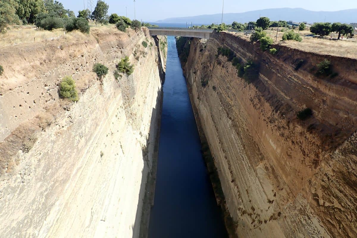
The canal links the Gulf of Corinth with the Saronic Gulf. It was dug through the Isthmus at sea level, has no locks and was completed in 1893. Its rock walls rise 90 m above sea level at a near-vertical angle of 80 degrees, and a railway line, a road and a motorway cross high above the channel.
Since 1988 two submersible bridges carry road traffic at sea level, one by the eastern harbour of Isthmia and one by the western harbour of Poseidonia. When a vessel arrives, the centre span sinks to 8 m below the water to let it cross. Loutraki tours that stop at Isthmia watch this crossing from the shore.
Ships pass one convoy at a time on a one-way system, and tugs tow the larger ships. The channel takes vessels up to 24.6 m wide with a draft of 7.3 m, so its traffic is now mainly tourist ships and smaller recreational boats, the craft that carry Loutraki tours through the cut. The passage saves a 700 km voyage around the Peloponnese.
- Length: 6,343 m, of which 540 m belong to the ports of Poseidonia and Isthmia.
- Width: 24.6 m at sea level and 21 m on the bottom.
- Depth: 8 m on the axis of the channel.
- Air draft: 52 m, set by the rail and road bridges.
The canal area falls under the Loutraki-Perachora community, although the canal marks part of its border with Corinth. Loutraki tours by boat see the walls from the water line, while road crossings give the view from above.
What history do Loutraki tours tell?
Loutraki tours tell the story of ancient Thermae and its hot springs, the Isthmus that the Roman emperor Nero began to cut in AD 67, the modern spa town that grew after 1847 and the rebuilding that followed the earthquake of 1928.
In antiquity the area was known as Peraia ge, the land across the water, and the village of Thermae stood on the site of Loutraki. Thermia Artemis was its protector. The Loutraki Tourism Organization records that Xenophon wrote of Spartan soldiers who rested at the waters of Thermae after battles.
The Isthmus, 6.3 km wide, was the ancient landmark between the Peloponnese and mainland Greece. In the 7th century BC Periander built the Diolkos, a stone trackway for hauling ships, and its remains lie next to the modern canal. Loutraki tours that continue to Isthmia reach the site of the Isthmian Games, held from 582 BC to the 5th century AD, with the ruins of the Temple of Poseidon, the stadium and the theatre. In the 5th century AD the marble of the Heraion went into a lime kiln for the Hexamilion wall across the Isthmus.
In 1847 a notice in Italy praised bathing in the Loutraki springs, and new settlers founded the modern town. Loutraki has been a recognised spa town since 1925. The earthquake of 1928 destroyed it, and the rubble of fallen houses reclaimed land from the sea for a large park. Another earthquake on 24 February 1981 brought down the eight-storey Apollon hotel, on the site where the casino later rose. Loutraki tours trace this past in the town’s buildings:
- Agios Andreas: a church built in 1345 by John Kantakouzenos in the area of the springs.
- Roman villa: a 2nd-century villa at Katounistra with a bath complex and a swimming pool.
- Casino: the first casino in Greece opened here in 1930, and the present one has run since 1995.
- Palace hotel: a five-storey hotel of 1923 on G. Lekkas Street, repaired after the 1928 earthquake.
Which beaches do Loutraki tours reach?
Loutraki tours reach the 3.5 km town beach, which runs from the Corinth Canal to the seaside park, and the Alkyonides Gulf shore north of the Geraneia range, where Schinos, Agia Sotira, Vamvakes and Mavrolimni sit beside the water.
Small pebbles cover the town beach, and the seabed drops away fast. The municipality keeps lifeguards on duty for safe swimming, showers stand along the full length, and the beach gives access to people with mobility problems. The Loutraki Tourism Organization states that the central beach has held the Blue Flag without a break since 1987. The shore faces west, so evening swims on Loutraki tours end with the sun setting behind the Corinthian coastline on one side and Cape Heraion on the other.
The Alkyonides Gulf forms the north-eastern arm of the Gulf of Corinth, about 25 km long and 20 km wide, and its water touches Corinthia, Attica and Boeotia. South of the gulf, the Pisia community groups five villages, and three of them, Agia Sotira, Vamvakes and Mavrolimni, stand on the coast. The area holds two beaches, one sandy with tavernas on the shore and one pebbly with almost no shops nearby, and Athenians use it as a weekend escape from the summer heat in Athens.
- Schinos: a small settlement at the foot of the Geraneia range, known for its beach.
- Mavrolimni: a lake that the 1981 earthquake joined to the sea, when a 30-metre stretch of its natural bank sank and left a new shore and beach.
- Vamvakes: a seaside village on the Attica border, about 32 km east-northeast of Loutraki, with the Alkyonides islands to its north-west.
- Isthmia: a village on the Saronic Gulf shore at the eastern entrance of the Isthmus, inside the same municipality as Loutraki.
The provincial road between Perachora and Schinos links the hill village with the Alkyonides shore, so Loutraki tours can pair a morning on the town beach with an afternoon on the gulf.
Which day trips combine with Loutraki tours?
Loutraki tours combine with Ancient Corinth, within 20 minutes of the town, with the Acrocorinth fortress above it, with Nemea, within 30 minutes, with the Isthmia sanctuary of Poseidon beside the canal, and with Mycenae, 48 km south of Corinth.
The ruins of Ancient Corinth lie about 5 km south-west of the modern city, and finds from the digs fill the Archaeological Museum of Ancient Corinth. The Temple of Apollo, built in the mid-6th century BC, has stayed in view since antiquity, and the American School of Classical Studies has excavated there since 1896. Paul the Apostle lived in the city for eighteen months. Loutraki tours to Ancient Corinth also cross the Roman forum that replaced the Greek agora.
Acrocorinth, a 575-metre rock, towers over the plain of Corinth, and the ancient city stood at its northern foot. Three circuit walls guard the hill, and its highest peak held a temple of Aphrodite that later became a church and then a mosque. The view from the top takes in the Corinthian and Patraic gulfs, the western Saronic, Salamis and Aegina.
At Nemea, the Temple of Zeus dates to about 330 BC; three of its 32 limestone columns have stood since construction, and two more went back up in 2002. The stadium joins its changing room through a 36 m vaulted tunnel, the earliest ancient Greek vault known. Isthmia lies 7.5 km south-east of Corinth at the Saronic end of the canal, and its sanctuary of Poseidon hosted the Isthmian Games, second only to the games at Olympia. Mycenae, 11 km north of Argos, makes the longest of these Loutraki tours and joined the UNESCO World Heritage List in 1999 together with Tiryns.
- Ancient Corinth: Temple of Apollo, Roman forum and site museum.
- Acrocorinth: a medieval castle site with the Upper Pirene spring inside its walls.
- Nemea: Temple of Zeus, stadium tunnel and site museum.
- Isthmia: ruins of the Temple of Poseidon, the ancient stadium, the ancient theatre and an archaeological museum.
- Mycenae: the Lion Gate and the Treasury of Atreus, on a hill 274 m above sea level.
How do visitors reach Loutraki for Loutraki tours?
Loutraki tours start 81 km west of Athens. Drivers reach the town in about an hour on the A8 Olympia Odos motorway, and rail users ride Athens Suburban Railway Line A4 to Corinth station, where a bus stop and a taxi rank stand outside.
The A8, known as Olympia Odos, starts at Elefsina and follows the Gulf of Corinth to Patras, and it forms part of European route E94 as far as the Moreas junction with the A7. The Elefsina–Corinth section reached motorway standard in the 1990s. At Kakia Skala, a bypass with five tunnels carries the traffic, and the longest tunnel, Evpalinos, runs for 1,700 m. Loutraki sits north-west of the Corinth Canal, so the town is not on the Peloponnese, and the canal lies 4 km to the south. That short gap lets a Corinth Canal day trip from Athens add Loutraki tours with little extra driving.
For rail-based Loutraki tours, Line A4 runs between Piraeus and Kiato with up to one train per hour, and the ride from Athens to Corinth takes about 55 minutes. Corinth station opened on 27 September 2005 on the edge of the city, 2.9 km from the centre near Examilia and the A8, and copies of ancient finds from its construction stand on display in the underpass to the platforms. KTEL Korinthias runs intercity coaches to Athens via the Isthmos station south-east of central Corinth, and buses serve Loutraki on regional and local routes.
- Road: a new entrance avenue and a ring road let drivers bypass the town centre.
- Rail: plans for the old Isthmos–Loutraki branch add a stop at the casino and a terminus on Aigaiou Street.
- Taxi: Loutraki keeps its own taxi network for local rides.
- Sea: Piraeus and Patras serve as passenger ports, and Corinth port takes cruise ship calls.
When do Loutraki tours run best?
Loutraki tours run best in the hot, dry summer for beach days, with July averaging 28.7 °C at the nearby Velo station, and in the Alkyonides days after Christmas, when clear skies and warm days last until mid-January.
The Velo weather station of the Hellenic National Meteorological Service places the Corinth area in the hot-summer Mediterranean climate, Köppen class Csa. Summers stay hot and dry, and winters turn cool and rainy. The year averages 18.1 °C, with about 463 mm of rain.
- July: the hottest month of the year at Velo.
- January: the coldest month, at an average of 9.1 °C.
- Christmas to mid-January: the Alkyonides days, when daytime highs in the Athens region can pass 20 °C.
- Late August or early September: the Great Days of Nemea, a three-day wine festival with tables set out on the pavements.
Summer sets the pace for Loutraki tours on the coast. Schinos draws visitors in the summer months, Mavrolimni has residents only in summer, and the Ilektra open-air cinema has screened films beside the sea for more than 60 years. The Loutraki Tourism Organization lists festivals and cultural events across the whole year, and the municipal hydrotherapy centre, working in the town centre since 2008, gives cool-season Loutraki tours an indoor stop.
Frequently Asked Questions
Which islands lie off the coast on Loutraki tours?
Loutraki tours on the Alkyonides shore face the Alkyonides islands, also called Kalanisa, near the Corinthian coast. The four islets, Zoodochos Pigi, Daskalio, Glaronisi and Prasonisi, are peaks of a reef that rests 190 m deep. They hold fish farms and ancient ruins and take their name from the daughters of the giant Alcyoneus.
Do Loutraki tours reach the Nemea wine country?
Loutraki tours reach Nemea within 30 minutes. The wider Nemea area forms the largest wine-growing zone in Greece and produces Nemea wines of Superior Quality Designation of Origin. Its wine has been known since antiquity, when the area was called the Phliasian Plain. The town keeps a wine museum beside traditional wineries.
Which mountain range rises above Loutraki tours routes?
The Geraneia range rises north and east of Loutraki and covers the northern isthmus between the Gulf of Corinth and the Saronic Gulf. Its highest peak, Makryplagi, reaches 1,351 m, and the range runs 30 km east to west. Loutraki tours to Perachora and Pisia climb its slopes, and the range holds the southernmost wolf pack in Greece.
Can Loutraki tours start from the port of Patras?
Yes. The Loutraki Tourism Organization puts the drive from the port of Patras at about two and a half hours on the Patras–Korinthos road. Loutraki tours from Patras follow the A8 Olympia Odos, whose Corinth–Patras section reached motorway standard in April 2017. That port handles a large share of passenger sea traffic between Greece and abroad.