
An Ephesus map shows a long ridge-and-valley city with two gates: the Upper Gate at the top and the Lower Gate near Selcuk. The main route runs downhill from the Upper Gate along Curetes Street to the Library of Celsus, then Marble Street to the Great Theatre in Ephesus. Plan the whole trip with Greece Tours.
This guide maps Ephesus in full: the layout of the ancient city, the two entrance gates, the downhill walking direction, what stands on Curetes Street, Marble Street and Harbour Street, where the Library of Celsus and Great Theatre sit, the sites outside the walled route, the distances and walking time, and a must-see order from the Upper Gate to the Lower Gate.
How is the ancient city of Ephesus laid out?
Ephesus sits in a valley between two hills, Panayır Dağı and Bülbül Dağı, and runs on one diagonal spine: from the Upper Gate at the south-east, down Curetes Street to the Library of Celsus, then along Marble Street and Harbour Street to the silted harbour at the north-west.
The city reads as a single sloping line drawn across the map from top-right to bottom-left. The Upper Gate, also named the Magnesia Gate, marks the highest point of the visitor route. From there the ground falls steadily toward the plain. The main paved axis bends once, at the Library of Celsus, where Curetes Street meets Marble Street at a near right angle. This bend is the pivot of the whole plan, and it is the single easiest landmark to fix in the mind before entering.
Two ridges frame the ruins. Panayır Dağı rises to the north-east and carries the Great Theatre against its lower slope. Bülbül Dağı climbs to the south-west and holds the Terrace Houses on its flank above Curetes Street. The buildings of state and civic life cluster at the top around the State Agora, the residences and grand marble monuments line the descent, and the commerce and entertainment structures spread across the flat ground at the bottom. Walking the axis moves the visitor forward through the social order of the city, from the council house at the summit to the market and harbour at the base.
The paved route measures close to three kilometres from the Upper Gate to the Lower Gate. A perimeter wall enclosed the classical core, and the modern ticketed path traces the heart of that enclosure. Monuments outside the wall, the Temple of Artemis and the Basilica of St John near Selçuk and the House of the Virgin Mary on Bülbül Dağı, stand apart and reach by separate roads.
Where are the two entrance gates on the Ephesus map?
The Upper Gate, or South Gate, sits at the top of the site beside the Selçuk-to-Aydın road near the Magnesia Gate; the Lower Gate, or North Gate, stands at the bottom on the plain near the Temple of Artemis and the town of Selçuk, close to the Basilica of St John.
The Upper Gate carries the official name South Gate on tickets and signs. It occupies the south-eastern edge of the archaeological park, on the higher ground where the ancient Magnesia Gate once controlled the road inland toward Magnesia and Aydın. A large coach and car park serves it directly. Entering here places the visitor at the top of the slope, with the State Agora and Odeon a short level walk ahead before the descent begins.
The Lower Gate carries the name North Gate. It lies at the north-western foot of the site, on the flat plain nearest to modern Selçuk. This gate opens beside the Great Theatre and Harbour Street end of the ruins. The Temple of Artemis stands about one and a half kilometres north-east of it, and the Basilica of St John on Ayasuluk Hill rises just beyond, inside Selçuk town. A second car and coach park serves the Lower Gate.
The two gates connect only through the ruins. No shortcut road links them inside the park, so the paved spine is the sole passage between them. This layout shapes every visit plan: a group entering one gate walks out of the other, or returns along the same street to the gate it started from. Drivers and coaches drop passengers at one gate and reposition to the other to collect them, which turns the walk into a clean one-way descent.
Which direction do you walk Ephesus — upper to lower?
Walk from the Upper Gate downhill toward the Lower Gate, heading broadly north-west. The full route runs about three kilometres end to end and drops steadily, so starting at the top turns the whole visit into a gentle descent rather than a climb in the heat.
Entering at the Upper Gate places the sun and the gradient in the visitor’s favour. The path leaves the gate on nearly level ground past the Odeon and State Agora, then tips downhill at Hercules Gate onto Curetes Street. From that point the surface falls away toward the Library of Celsus. Gravity does the work. The reverse direction, from the Lower Gate upward, forces a continuous climb up Curetes Street in full exposure, which drains a visit fast in summer.
The compass bearing of the main descent runs to the north-west. Curetes Street points down and away from the Magnesia Gate, the Library sits at its lower north-western end, and Harbour Street then strikes due west across the plain toward the old shoreline. Panayır Dağı stays on the right hand for most of the walk, and Bülbül Dağı with its Terrace Houses stays on the left. Keeping the two hills in these positions confirms the walker faces the correct way.
Distance builds gradually. The upper civic quarter takes the first stretch, the marble monuments of Curetes Street fill the middle, and the theatre and harbour spread across the final section on flat ground. A steady pace with stops covers the three kilometres inside a half-day. The single downhill logic is the key fact that governs the whole plan of a visit.
What is on Curetes Street and where?
Curetes Street runs downhill from Hercules Gate at the top to the Library of Celsus at the foot. It passes, in order, the Temple of Domitian, the Trajan Fountain, the Temple of Hadrian, the Scholastica Baths, the Terrace Houses on the left, and the public latrines and brothel near the bottom.
The State Agora, Odeon, and Temple of Domitian cluster at the upper entrance to the street. The Odeon, a small roofed council chamber, seats the eastern edge of the State Agora. The Temple of Domitian stands just south of the agora on a high terrace. Hercules Gate then narrows the road, marking the start of the steep pedestrian descent and the point where wheeled traffic stopped. Its two carved pillars show Hercules wrapped in the Nemean lion’s skin.
Below Hercules Gate the monuments line both sides. The Trajan Fountain, a two-storey nymphaeum, sits on the left a short way down. Past it the ornate Temple of Hadrian faces the street with its famous arched façade and the head of Medusa in the pediment. Behind and above the temple rise the Terrace Houses, the covered slope-side residences of the wealthy, reached by a separate ticket. The Scholastica Baths stand beside the Hadrian temple.
Near the foot of the street, before the Library, sit the civic facilities of daily Roman life. The public latrines occupy a colonnaded room with rows of marble seats over a running drain. Close by, a building identified as the brothel stands at the junction where Curetes Street meets Marble Street. The full descent of Curetes Street, with its fountains, temples, shopfronts and mosaics, forms the richest concentration of standing monuments in the city. A dedicated guide to the whole avenue sits at Curetes Street.
Where is the Library of Celsus on the map?
The Library of Celsus stands at the foot of Curetes Street, at the elbow where that street turns into Marble Street. Its two-storey marble façade faces up the slope, and the triple-arched Gate of Mazeus and Mithridates opens on its right into the Commercial Agora.
The Library is the visual anchor of the entire site and the natural halfway landmark of the walk. It sits at the lowest point of Curetes Street, on the north-western end, where the paved axis bends. A walker coming down the hill sees the reconstructed façade grow larger with every step until it fills the view. The building faces east so that morning light strikes its columns and statue niches full on, which fixes its orientation on the map.
To the immediate right of the Library stands the Gate of Mazeus and Mithridates, a three-bay triumphal arch. It leads through the south wall of the Commercial Agora, the great square market that occupies the flat ground between the Library and the harbour road. This gate ties the two spaces together and explains the crowding of the junction: books, commerce and processional streets all met at this one corner. The Library’s front terrace forms the widest open plaza on the route.
From this elbow the map splits the onward walk into two arms. Marble Street heads north from the Library toward the Great Theatre. Harbour Street, reached beyond the theatre, strikes west toward the vanished port. The Library therefore marks both the mid-point of the descent and the decision corner where the axis changes direction. A full account of the monument sits at the Library of Celsus page.
What is on Marble Street and Harbour Street?
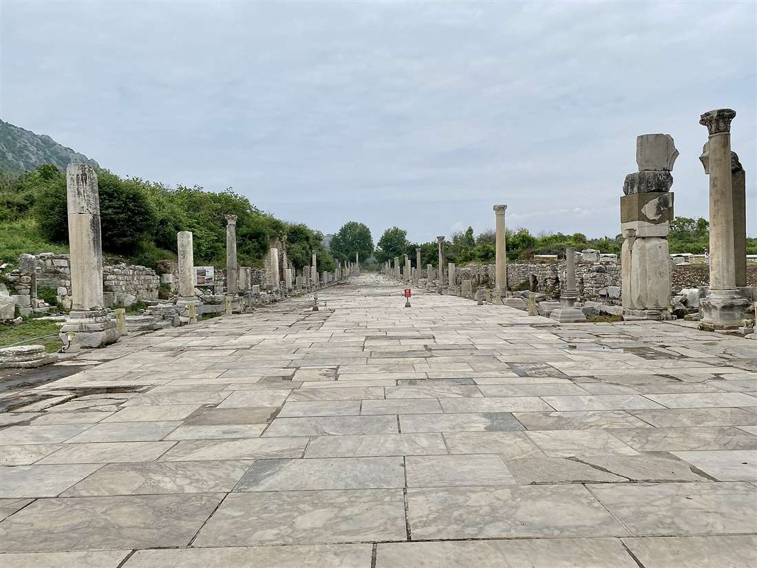
Marble Street runs north from the Library of Celsus to the Great Theatre, paved in white marble slabs with the carved footprint advertisement set into its surface. Harbour Street, also named the Arcadian Way, then strikes west from the theatre across the plain toward the silted harbour.
Marble Street begins at the Library elbow and heads north with the Commercial Agora on its left and the slope of Panayır Dağı on its right. Deep ruts from cart wheels score its stone, and a raised colonnaded footway once sheltered pedestrians from the traffic. Set into the paving on the western side is the celebrated footprint carving, a foot, a heart and a female head cut into the marble, read as a signpost pointing toward the brothel quarter. The street runs straight to the foot of the theatre.
At the theatre the axis turns west. Harbour Street, the Arcadian Way, leaves the theatre forecourt and drives in a broad colonnaded line toward the water. This avenue was the grand processional entrance for anyone arriving by sea. Rows of columns flanked its full length, and street lamps once lit it after dark, a rarity in the ancient world. Shops and covered walkways lined both sides.
The harbour itself no longer holds water. The Küçük Menderes river, the ancient Cayster, carried silt into the bay across the centuries until the shoreline retreated five kilometres to the west, leaving Ephesus stranded inland on a marshy plain. Harbour Street now ends at reed beds and open field rather than a quay. Walking its length to the end and looking back east frames the theatre and the whole city rising up the valley, the finest single view on the site.
Where is the Great Theatre on the Ephesus map?
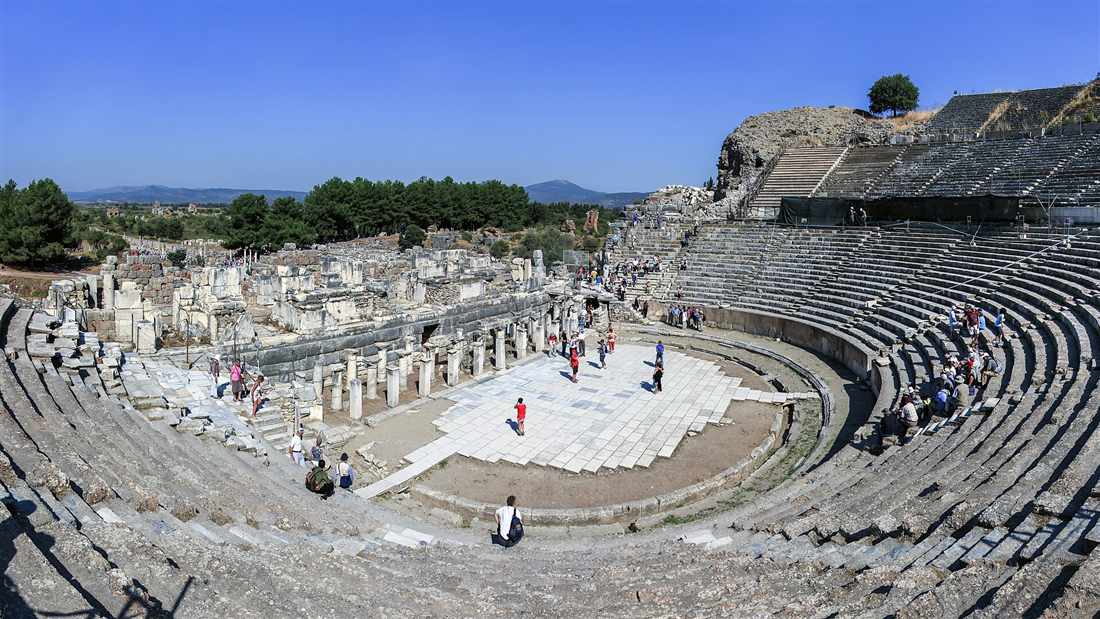
The Great Theatre stands on the east side of the site, at the junction where Marble Street from the south meets Harbour Street running west. It is cut into the lower slope of Panayır Dağı and seats about twenty-five thousand people, the largest structure in the city.
The theatre dominates the northern half of the map. Its huge semicircular bowl faces west, hollowed into the hillside so that the rising tiers of seats climb the natural slope of Panayır Dağı. From the top rows the view sweeps straight down Harbour Street to the plain where the sea once lay. This westward aspect means the stage building sits at the bottom, on the flat, with the audience banked above it against the hill.
Its position at the meeting of two streets made it the pivot of city life. Crowds arriving from the harbour walked up the Arcadian Way to its doors, and crowds from the upper city came down Marble Street to the same point. The structure served drama, assembly and gladiatorial contest across its long history. It is the building where the New Testament records the silversmiths’ riot against Paul, which fixes it in the record of the first century.
Three architectural tiers make up the whole: the curved seating bank, or cavea, split into levels by walkways; the semicircular orchestra at its foot; and the tall multi-storey stage front, the skene, that closed the open side. The scale reads clearly from Harbour Street, where the full bowl rises ahead. A detailed account sits at the Great Theatre of Ephesus page.
What lies outside the walled route — Temple of Artemis, Basilica of St John, House of the Virgin Mary?
Three major monuments stand outside the ticketed ruins. The Temple of Artemis and the Basilica of St John sit near the Lower Gate on the edge of Selçuk, while the House of the Virgin Mary rests seven kilometres up Bülbül Dağı by a separate mountain road to the south.
The Temple of Artemis lies on the plain between the Lower Gate and Selçuk town, about one and a half kilometres from the North Gate. One reassembled column now marks the site of what was one of the Seven Wonders of the ancient world, a temple that once carried more than a hundred marble columns. Its low, marshy field sits below the Basilica hill and draws its own short visit. Full detail sits at the Temple of Artemis page.
The Basilica of St John crowns Ayasuluk Hill inside Selçuk, just north of the Temple of Artemis. Built over the reputed tomb of John the Apostle, its ruined nave and columns overlook the town, the Artemis field and the whole Ephesus valley. The Byzantine fortress and the Isa Bey Mosque stand on the same hill, grouping three eras of monument within a short walk of the Lower Gate.
The House of the Virgin Mary sits high and apart. It rests on the wooded slope of Bülbül Dağı, the hill south-west of the ruins, reached by a winding road that climbs about seven kilometres from the site. The small stone chapel, held by tradition to be the last home of Mary, draws pilgrims of both Christian and Muslim faith. Its mountain setting places it well off the main walking route and it needs its own drive. A full account sits at the House of the Virgin Mary page.
How far apart are the monuments and how long is the walk?
The main downhill route from the Upper Gate to the Lower Gate covers close to three kilometres, and a steady visit with stops at each monument takes two to three hours. The stretches between landmarks are short, most of them a few hundred metres.
From the Upper Gate to the Odeon and State Agora is a level walk of about two hundred metres. Hercules Gate follows soon after, and from there the descent of Curetes Street to the Library of Celsus runs roughly four hundred metres downhill past the temples, fountains and Terrace Houses. This central stretch holds the densest run of monuments and absorbs the most time, since the Trajan Fountain, Temple of Hadrian, Scholastica Baths and latrines all stand within a short span of one another.
From the Library, Marble Street to the Great Theatre measures about two hundred and fifty metres north. Harbour Street then extends roughly five hundred metres west from the theatre to the old harbour edge, and the same distance back for anyone returning. From the theatre to the Lower Gate is a further level walk of a few hundred metres to the exit. The Terrace Houses add extra time inside their covered walkways for those who buy the separate ticket.
Two hours suits a brisk walk that pauses at the headline monuments. Three hours suits a fuller visit that enters the Terrace Houses, walks the length of Harbour Street to its end and lingers in the theatre. Summer heat lengthens every estimate, since shade is scarce on the open marble and the midday sun bears down on the exposed streets. An early start or a late afternoon avoids the fiercest heat and the thickest crowds.
How do you read the Ephesus site map and plan a route?
Read the map as one downhill line and start at the Upper Gate to save the climb. Enter at the top, walk north-west down the paved spine, and exit at the Lower Gate. Coach and car drop-offs sit at both gates, so a driver repositions from one to the other.
The single most useful fact on the map is the gradient. The Upper Gate stands high and the Lower Gate stands low, so entering at the top turns the whole visit into a descent. Groups on organised tours enter the Upper Gate for this reason, walk the length of the ruins downhill, and meet their coach at the Lower Gate. Independent visitors without a return driver either accept a one-way walk and a taxi back, or plan a return climb up the same streets.
Orientate on the Library of Celsus. It sits at the mid-point and the bend of the axis, and it appears on every printed map as the central landmark. Fixing the Library in the mind divides the route into two halves: the marble-monument descent of Curetes Street above it, and the theatre-and-harbour flatland below it. The two framing hills confirm the direction, with Panayır Dağı and its theatre on the north-east and Bülbül Dağı and its Terrace Houses on the south-west.
Match the entry gate to the plan. A visitor combining Ephesus with the Temple of Artemis and the Basilica of St John enters or exits at the Lower Gate, since those monuments lie beside it near Selçuk. A visitor arriving from the Aydın direction reaches the Upper Gate first. Buying the Terrace Houses ticket at the entrance saves a second queue inside. Water, a hat and firm shoes turn the marble descent from a trial into a straightforward walk, since the ancient paving is uneven and the sun is unbroken.
What are the must-see stops in walking order?
The walking order from the Upper Gate to the Lower Gate runs: State Agora and Odeon, Temple of Domitian, Hercules Gate, Trajan Fountain, Temple of Hadrian, Terrace Houses, latrines and brothel, Library of Celsus, Marble Street, Great Theatre, and Harbour Street to the exit.
The sequence begins on the level ground inside the Upper Gate. First stands the State Agora with the Odeon council chamber on its eastern side, then the Temple of Domitian on its terrace to the south. A short walk brings the first Hercules Gate, whose lion-skin pillars mark the head of Curetes Street and the start of the true descent. From here the route tips downhill and the great marble monuments begin in quick succession.
Down Curetes Street the order is fixed by the slope. The Trajan Fountain comes first on the left, then the arched Temple of Hadrian, with the entrance to the Terrace Houses climbing the hillside just above and behind it. The Scholastica Baths sit beside the temple. Lower still stand the colonnaded public latrines and, at the junction with Marble Street, the building named as the brothel. The street then delivers the walker to the open terrace before the Library of Celsus, the halfway prize of the whole visit.
Beyond the Library the route turns and the last monuments follow. Pass through or beside the Gate of Mazeus and Mithridates into the Commercial Agora, then walk north up Marble Street, watching for the carved footprint in the paving, to reach the Great Theatre banked against Panayır Dağı. From the theatre forecourt, Harbour Street runs west toward the silted port, its columns pointing at the vanished sea. Walking to its end and looking back frames the whole descended city in one view before the Lower Gate ends the visit. This eleven-stop line, top to bottom, is the complete downhill sequence of Ephesus.
How do the two hills, Panayır Dağı and Bülbül Dağı, orient the map?
The two hills fix north-east and south-west on the Ephesus map. Panayır Dağı rises to the north-east and carries the Great Theatre on its slope; Bülbül Dağı climbs to the south-west and holds the Terrace Houses. The valley between them channels the whole paved axis.
Panayır Dağı, the smaller and more northerly hill, stands on the walker’s right for most of the descent. Its western flank cradles the Great Theatre, cut straight into the rock so the seating climbs the natural gradient. The State Agora and the upper civic quarter also sit close to its southern foot. Keeping this hill on the right hand from Curetes Street onward confirms the walker faces north-west toward the Library and the harbour.
Bülbül Dağı, the taller southern ridge, stands on the walker’s left. Its lower slope above Curetes Street carries the Terrace Houses, the stepped residences of the rich that climb the hillside in covered terraces. Higher up the same mountain, seven kilometres by road, sits the House of the Virgin Mary. This hill blocks the south-western horizon and marks the direction of the old city wall that ran along its crest.
Between the two ridges lies the funnel of flat and sloping ground that holds the ruins. The valley opens to the west toward the vanished sea and closes to the east at the Magnesia Gate. The paved spine follows this natural corridor, which is why the city reads as one clean diagonal rather than a grid. Reading the hills first, then the streets, turns a confusing field of marble into a legible map.
Where does the Commercial Agora sit on the map?
The Commercial Agora, the great square market, occupies the flat ground west of Marble Street and north of the Library of Celsus. The Gate of Mazeus and Mithridates opens into its southern corner beside the Library, and Marble Street runs along its eastern edge toward the theatre.
The Commercial Agora, also named the Tetragonos Agora for its square plan, formed the trading heart of Roman Ephesus. It measures roughly one hundred and ten metres on each side, a vast colonnaded court ringed by shops on all four sides. Its position on the flat plain, close to both the Library and the harbour road, placed it at the meeting of learning, commerce and the sea traffic that fed the city’s wealth.
Three approaches reach the square. The Gate of Mazeus and Mithridates enters from the south, beside the Library, through its triple marble arch. A western gate opened toward the harbour, giving merchants a direct line from ship to stall. Marble Street bounds the eastern side, so goods unloaded at the port passed straight into the market and up into the city. The open central court once held stalls and traders under the sun while the shaded colonnades held the permanent shops.
On the map the agora fills the block between the Library elbow and the theatre approach. A walker leaving the Library terrace and turning north onto Marble Street keeps the agora on the left the whole way. Its scale explains the crowding of the Library junction, where the market gate, the book-house and two major streets all converge on one corner of the plain.
What marks the top of the site at the Upper Gate?
The upper quarter holds the political and religious core of Ephesus. Inside the Upper Gate stand the State Agora, the Odeon council chamber, the Prytaneion with its eternal flame, the Memmius Monument, and the Temple of Domitian, all on nearly level ground before the descent begins.
The State Agora is the first great open space past the Upper Gate. Unlike the Commercial Agora below, this square served government and civic ceremony rather than trade. A temple stood in its centre, and a long stoa closed its northern side. The Odeon, a small roofed theatre seating about fourteen hundred, banks against the agora’s eastern edge and served the city council and musical performance under a covered roof.
The Prytaneion stands close by, on the northern side of the State Agora. This civic hearth-house guarded the sacred flame of Hestia, kept burning for the life of the city, and it was here that the two famous statues of Artemis of Ephesus were found. West of it the Memmius Monument, a tall square memorial to a grandson of the dictator Sulla, marks the junction where the level upper ground begins to fall toward Curetes Street.
The Temple of Domitian occupies a high terrace on the south side of this quarter, raised above the street on a broad platform. It was the first temple in the city dedicated to a Roman emperor. Together these monuments form the summit cluster of the visit, the seat of law, cult and council, and they set the pattern for the descent, since the walk moves from the governing top of the city to the trading and playing bottom.
Why did the Ephesus harbour silt up and move off the map?
The Küçük Menderes river, the ancient Cayster, carried silt down into the bay for centuries and choked the port. The shoreline retreated westward across the plain until Ephesus stood five kilometres inland, and Harbour Street now ends at reed beds instead of open water.
Ephesus began as a coastal city with a working harbour at the end of Harbour Street. Ships tied up at quays where merchants unloaded goods straight into the Commercial Agora. The wealth of the city rested on this sea link, and the grand colonnaded Arcadian Way was built to impress every visitor who stepped ashore. The harbour was the front door of Ephesus.
The river undid it. The Cayster drains a wide valley and carries a heavy load of soil down to the coast. Season after season it dropped that soil into the sheltered bay, and the water grew shallow. The Ephesians dredged the basin repeatedly to keep it open, but the silt won. The land advanced, the sea withdrew, and the marsh spread across the old anchorage until ships found no depth to float in.
On the modern map the effect is stark. Harbour Street runs due west from the theatre and stops in flat field and reed. The blue of the Aegean now lies five kilometres beyond the ruins, out of sight from the site. This retreat drained the city’s trade, spread malaria across the new marsh, and drove the population toward the higher ground at Selçuk, which is one long thread of why the great city fell quiet. Standing at the western end of Harbour Street and reading the empty plain shows the single geographic fact that shaped the whole history of Ephesus.
Which gate suits a cruise or day visitor arriving from Kuşadası?
A visitor arriving by cruise ship at Kuşadası or by road from Selçuk reaches Ephesus in about twenty minutes by car. Tour coaches enter at the Upper Gate to walk the downhill route, then collect passengers at the Lower Gate near the Temple of Artemis and Selçuk.
Kuşadası port lies roughly twenty kilometres south-west of Ephesus, a short transfer along the main road. Cruise passengers on a shore excursion travel in coaches that drop them at the Upper Gate car park at the top of the site. This lets the group walk the whole city as a single downhill line and rejoin the coach at the Lower Gate without doubling back, the same logic that governs every organised tour.
The town of Selçuk sits at the foot of the site, next to the Lower Gate. A visitor staying in Selçuk walks or takes a short taxi ride to the Lower Gate and either climbs the route from bottom to top or takes transport up to the Upper Gate to walk down. The Selçuk train station links the town to İzmir, and the Temple of Artemis and the Basilica of St John stand within Selçuk itself, close to the Lower Gate.
The gate choice follows the plan. A one-way downhill walk with a waiting driver argues for the Upper Gate start and Lower Gate finish. A visit that pairs Ephesus with the Artemis and St John sites argues for arriving or leaving at the Lower Gate, since those monuments cluster beside it. Independent visitors without a return driver weigh the easier downhill walk against the return climb up the same marble streets.
Where do the shade, water and rest points sit along the route?
Shade is scarce on the open marble streets of Ephesus. The main shaded stops sit at the roofed Terrace Houses above Curetes Street, inside the Great Theatre’s lower galleries, and at the café and facilities near the Lower Gate. The exposed streets between them carry full sun.
The two long paved avenues, Curetes Street and Harbour Street, run open to the sky with no tree cover and little standing shade. Marble reflects heat upward, so the midday walk down these stretches bears the strongest sun of the visit. The upper State Agora quarter and the theatre bowl offer the only broken shade along the spine, and neither holds it for long as the sun moves.
The roofed Terrace Houses form the one genuinely covered stop on the route. Their modern protective shelter shades the whole complex, so the separate ticket buys both mosaics and a break from the heat halfway down Curetes Street. The Great Theatre’s vaulted entrance passages, the vomitoria beneath the seating, hold cool air, and the deep galleries give a moment out of the sun near the bottom of the walk.
Facilities cluster at the gates rather than in the middle. Toilets, a café and drinking water sit near the Lower Gate and the main entrances, not along the ruins themselves. Carrying water from the start, wearing a hat, and timing the walk for early morning or late afternoon answers the exposure. The downhill direction helps here too, since the hardest, hottest effort of a climb falls away when the route runs top to bottom.
Frequently Asked Questions
How do you read an Ephesus map?
An Ephesus map runs from the Upper Gate at the top down a valley to the Lower Gate. Curetes Street drops to the Library of Celsus, Marble Street turns north to the Great Theatre, and Harbour Street heads west to the old port.
Which Ephesus gate do you start from?
Start at the Upper Gate on the Selcuk-Aydin road and walk downhill to the Lower Gate near the Temple of Artemis. The one-way downhill route saves the climb and passes the monuments in order.
How long is the walk through Ephesus?
The main route through Ephesus runs about 3 kilometres from the Upper Gate to the Lower Gate. A steady walk takes 2 to 3 hours, longer with the Terrace Houses and the museum finds.