
The island of Kos stretches across about 290 square kilometres of the eastern Aegean, a long, narrow strip of land lying close to the Turkish coast near Bodrum. This third-largest Dodecanese island is the birthplace of Hippocrates, the father of medicine. Home to the Asklepion. A terraced ancient healing sanctuary dedicated to Asclepius that stands about 4 kilometres southwest of the capital. Kos Town itself blends ancient Greek agora ruins, Roman villas and an imposing Knights’ castle at the harbour, all threaded by flat, cycle-friendly streets that make exploration effortless. Beyond the capital, the island unfolds into a patchwork of north-coast beaches. Plan the whole trip with Greece Tours.
Mountain villages perched on the slopes of Mount Dikeos and a southwestern bay dotted with islets and basilica ruins.
Visitors to Kos discover a rare combination of accessible archaeology, easy cycling terrain and varied coastline. The flat topography encourages bicycle tours along coastal roads that link beach resorts such as Tigaki, Marmari and Mastichari on the north shore, while the southwest bay around Kefalos offers Paradise, Camel and Agios Stefanos beaches beside turquoise shallows. Day boats depart the harbour for the volcanic island of Nisyros, the sponge-diving centre of Kalymnos and the Turkish port of Bodrum, adding international flavour to a Greek island stay. From soaking in the hot springs at Therma beach to watching the sun set from Zia village at 846 metres.
The island balances ancient pilgrimage sites with modern resort comforts across its 40-kilometre length.
What makes the Asklepion the most important ancient site on Kos?
The Asklepion served as a terraced healing sanctuary dedicated to Asclepius, the god of medicine, and functioned as both a religious shrine and a medical school where Hippocratic physicians trained.
The lowest terrace held administrative buildings, baths and accommodation for pilgrims who travelled to the sanctuary seeking cures for ailments ranging from broken bones to chronic disease. A monumental staircase connected this level to the middle terrace, where a grand altar and smaller temples stood among shaded colonnades. Physicians combined ritual purification, herbal remedies and surgical procedures in treatment protocols that blended religious faith with empirical observation. The sanctuary’s reputation grew after Hippocrates established his medical teachings on the island, and successive generations of healers expanded the complex to accommodate growing numbers of patients and students.
The middle terrace featured an Ionic temple and a large altar where sacrifices honoured Asclepius before any medical intervention began. Patients underwent dream incubation in the abaton, a long dormitory where priests interpreted visions as divine guidance for treatment. Spring water flowed through channels to supply baths and drinking fountains, and the mineral content of the water was believed to enhance healing. Inscriptions on stone tablets recorded successful cures, serving as testimonials that attracted new visitors and reinforced the sanctuary’s prestige across the Hellenistic world.
The uppermost terrace crowned the complex with a Doric temple of Asclepius, its columns framing views across the coastal plain to the sea and the Turkish mountains beyond. This temple, rebuilt during the Roman period, stood as the spiritual heart of the sanctuary, where priests conducted ceremonies and stored votive offerings left by grateful patients. The terraced design allowed processions to ascend through increasingly sacred spaces, mirroring the journey from illness to health. Excavations have uncovered surgical instruments, medical texts inscribed on stone and fragments of statuary that illustrate the fusion of science and religion in ancient healing practices.
Visitors today walk the same marble steps that ancient pilgrims climbed, passing reconstructed columns and foundation walls that outline the original floor plans. Interpretive panels explain the function of each building, from the Roman baths at the entrance to the temple ruins at the summit. Pine trees shade the terraces, and wildflowers bloom among the stones in spring. The site opens daily, and the climb to the top terrace takes about 30 minutes at a leisurely pace, rewarding effort with panoramic views over Kos Town and the straits separating Greece from Turkey.
How does Kos Town combine ancient ruins with modern island life?
Kos Town spreads across a flat grid where ancient Greek agora foundations, Roman mosaics and a medieval castle share space with Italian-era arcades, waterfront caf\u00e9s and bicycle lanes.
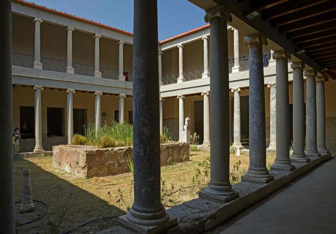
The ancient agora occupies a broad archaeological zone in the heart of the modern town, its columns and paving stones exposed below street level. Visitors descend steps to walk among the remains of stoas, shrines and public buildings that formed the commercial and civic hub of Hellenistic Kos. A restored odeon with marble seating tiers hosts occasional concerts, and nearby the Casa Romana preserves three peristyle courtyards decorated with floor mosaics depicting marine scenes and geometric patterns. The Roman villa, reconstructed in the early twentieth century. Offers a rare glimpse of domestic architecture from the second and third centuries, complete with frescoed walls and a private bath complex.
The Castle of Nerantzia rises on a stone platform at the harbour mouth. Its double curtain walls and towers built by the Knights of Saint John to defend against Ottoman raids. A stone bridge crosses the former moat, now a palm-lined avenue. The castle interior encloses a grassy courtyard scattered with marble fragments and inscriptions salvaged from earlier Greek and Roman buildings. Rampart walks provide views over the marina, where fishing boats and excursion vessels tie up alongside modern yachts. The fortification illustrates the strategic importance of Kos as a waypoint between Rhodes and the Anatolian coast. Its walls incorporate ancient column drums and carved blocks recycled from pagan temples.
The Plane Tree of Hippocrates spreads its branches over a stone platform beside the castle bridge, its massive trunk supported by metal scaffolding. Tradition holds that Hippocrates taught students in the shade of this tree, though dendrochronology suggests the current specimen is around 500 years old, a descendant of earlier trees rooted in the same spot. The tree has become a symbol of the island’s medical heritage, and a small Ottoman fountain stands nearby, its Arabic inscription dating to the eighteenth century. Benches encircle the trunk, and the square fills with locals and tourists throughout the day, blending historical reverence with everyday social life.
Bicycle lanes stripe the town’s main avenues, connecting the harbour to residential neighbourhoods and beach promenades in a network that extends across the flat coastal plain. Rental shops line the waterfront, offering city bikes, mountain bikes and electric models for exploring the island’s 40-kilometre length. The Italian administration of the early twentieth century laid out wide boulevards and planted palm trees, creating a Mediterranean urban landscape that complements the ancient ruins.
Markets, bakeries and tavernas occupy neoclassical buildings with arcaded ground floors, and the town’s compact scale makes walking or cycling the most practical way to navigate between archaeological sites, museums and the ferry port where how to get to Kos becomes a question answered by hydrofoils, ferries and flights arriving daily.
Which beaches on Kos offer the best swimming and scenery?
Tigaki and Marmari stretch along the north coast with shallow, sandy entries and views toward Kalymnos, while the southwest bay around Kefalos features Paradise, Camel and Agios Stefanos beaches beside rocky headlands and the Kastri islet.
Tigaki beach extends for about 10 kilometres along the northern shore. A broad ribbon of pale sand backed by low dunes and salt-pan wetlands that attract migrating flamingos in spring and autumn. The seafloor slopes gently, and water depth remains comfortable for wading 50 metres from shore, making the beach popular with families. Tamarisk trees provide scattered shade, and a paved coastal road links the beach to the village of Tigaki, where small hotels and tavernas cluster around a central square. Windsurfing schools operate at the western end, where afternoon breezes funnel through the channel between Kos and Pserimos island, and kiteboarders launch from designated zones marked by buoys.
Marmari beach lies about 3 kilometres east of Tigaki, separated by a shallow lagoon fringed with reeds and salt-tolerant grasses. The sand here is finer and whiter, and the water takes on a turquoise hue over the pale seabed. A few beach bars rent sunbeds and umbrellas, but much of the shoreline remains undeveloped, allowing visitors to spread towels on open sand. The lagoon behind the beach supports birdlife including herons, egrets and occasional pelicans, and a dirt track runs along the inland edge for cyclists and walkers. Marmari village sits about 1 kilometre inland, a quiet settlement of whitewashed houses and small farms growing tomatoes, cucumbers and melons in irrigated plots.
Paradise beach curves along the southern flank of Kefalos bay, a crescent of coarse sand and smooth pebbles facing west toward the open Aegean. The beach earned its name from the clarity of the water, which reveals rock formations and seagrass beds at depths of 3 to 5 metres. Camel beach lies just north, named for a hump-shaped rock offshore, and both beaches share the same crystalline conditions and lack of development. A dirt road descends from the main coastal highway, and a single seasonal taverna serves grilled fish and salads under a bamboo canopy.
Snorkellers explore the rocky margins where damselfish and wrasse dart among the stones, and the western exposure delivers spectacular sunsets that paint the cliffs in shades of orange and pink.
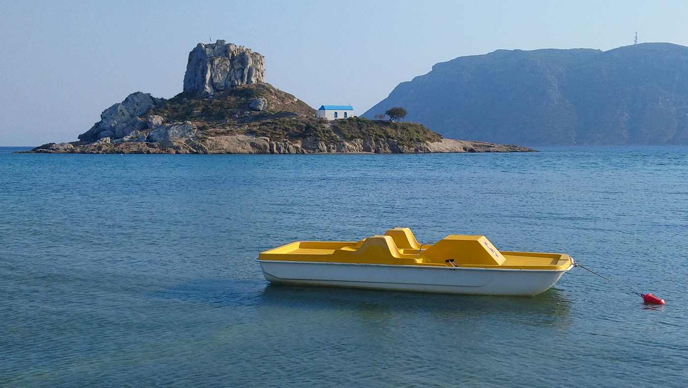
Agios Stefanos beach occupies the northern tip of Kefalos bay. Distinguished by the twin-apsed ruins of a fifth-century basilica standing on the sand and the small Kastri islet rising 200 metres offshore. The basilica’s floor mosaics remain partially intact, protected by a wire fence, and the columns of the nave lie toppled in geometric rows. The beach itself is a mix of sand and pebble, and the shallow water extends toward Kastri, which visitors wade or swim to at low tide. A whitewashed chapel crowns the islet’s rocky summit, and the climb takes about 10 minutes up a rough footpath.
The combination of archaeological remains, clear water and island views makes Agios Stefanos a favourite stop for those exploring Kos beaches by car or scooter.
What draws visitors to Zia village on the slopes of Mount Dikeos?
Zia clings to the northern flank of Mount Dikeos at about 300 metres elevation, offering panoramic views over the coastal plain, Kos Town and the Turkish mountains across the straits.
The drive to Zia climbs through olive groves and terraced vineyards, the road switchbacking up the mountainside from the main coastal highway near the village of Zipari. The ascent takes about 20 minutes from Kos Town, and the temperature drops noticeably as elevation increases, providing relief from summer heat on the coast. Zia’s main street is a pedestrian lane paved with stone slabs, lined with shops selling honey, herbs, woven textiles and ceramic pottery produced in local workshops. The scent of oregano, thyme and sage fills the air, and vendors offer samples of mountain honey harvested from hives on the upper slopes of Dikeos.
Tavernas occupy stone-built terraces on the western edge of the village, their tables arranged to face the sunset over the Aegean. Diners arrive in the late afternoon, ordering mezze platters, grilled lamb and local wine while waiting for the sun to descend toward the horizon. The view encompasses the entire northern coastline from Tigaki to Mastichari. The salt pans glinting silver in the fading light. The silhouettes of Kalymnos and Pserimos islands darkening against the sky. On clear evenings, the Turkish coast appears as a jagged line of peaks tinged with purple and gold. The lights of Bodrum begin to twinkle as dusk deepens into night.
The Church of the Nativity of the Virgin stands at the upper end of the village. A small Byzantine structure with a red-tiled roof and a bell tower that chimes on the hour. Frescoes inside the church date to the fourteenth century, though later restorations have obscured some of the original paintwork. A spring flows from a stone fountain beside the churchyard. Locals fill bottles with the cold mountain water, which is said to have a sweeter taste than the coastal supply. A footpath continues beyond the church, climbing toward the summit of Mount Dikeos through a forest of Aleppo pine and Calabrian pine. The trail marked with red paint blazes on rocks and tree trunks.
The summit of Mount Dikeos reaches 846 metres, the highest point on Kos, and the hike from Zia takes about 90 minutes one way over rocky terrain. Hikers pass abandoned stone huts and terraced fields reclaimed by scrub, and the upper slopes open into alpine meadows dotted with wildflowers in spring. The peak offers 360-degree views: the Dodecanese islands scattered to the south, the Bodrum peninsula to the east, and the long spine of Kos stretching southwest toward Kefalos. A small chapel dedicated to the Metamorphosis stands near the summit, its whitewashed walls a landmark visible from the coast. Descending to Zia in time for sunset completes a full day of hiking and sightseeing.
The village tavernas provide a comfortable setting to rest and reflect on the island’s varied landscapes.
How does cycling shape the experience of exploring Kos?
Kos ranks among Greece’s flattest islands, and a network of paved bike paths and low-traffic coastal roads connects Kos Town to beaches, villages and ancient sites across the island’s 40-kilometre length.
The main coastal cycle path begins at the harbour in Kos Town and follows the northern shoreline west toward Lambi beach. A distance of about 3 kilometres on smooth asphalt separated from car traffic by a painted line. The route passes hotels, beach bars and small parks planted with oleander and bougainvillea, and the flat terrain requires minimal effort. Cyclists continue beyond Lambi to reach Tigaki, a further 8 kilometres along a road that runs parallel to the beach, with frequent access points to the sand. The entire ride from town to Tigaki takes about 45 minutes at a relaxed pace, and the return journey benefits from prevailing afternoon breezes that blow from the northwest.
A second cycle route heads southeast from Kos Town along the coastal road toward the Asklepion and the village of Platani, a round trip of about 10 kilometres. The road climbs gently through residential neighbourhoods and past fields of tomatoes and cucumbers, then descends to the archaeological site entrance. Cyclists lock bikes at the Asklepion gate and explore the terraced sanctuary on foot, then continue to Platani. A village known for its Turkish heritage and tavernas serving kebabs and pide flatbread. The return to town follows the same route, though a parallel inland road offers an alternative through quieter farmland.
Longer rides venture to the southwest coast, where the road to Kefalos and Kamari covers about 40 kilometres from Kos Town. This route crosses the island’s central plain, passing the airport near Antimachia and climbing over low hills before descending to the bay. The distance and occasional climbs make the journey more suitable for experienced cyclists or those using electric bikes, which rental shops now stock in growing numbers. Rest stops in Antimachia and Kardamena break the ride into manageable segments. The reward is access to Paradise. Camel and Agios Stefanos beaches, which see fewer visitors than the northern resorts.
Cyclists often load bikes onto buses for the return trip, as public transport on Kos accommodates bicycles in designated racks.
The flat topography and mild climate extend the cycling season from April through October, with summer temperatures moderated by sea breezes that keep coastal routes comfortable even at midday. Bike rental costs around 5 to 10 euros per day, and shops provide helmets, locks and route maps marked with points of interest. The island’s compact size and well-maintained roads make it practical to cover significant distances without the need for a car. The slower pace of cycling encourages stops at roadside shrines. Fruit stands and unmarked beaches that drivers pass without noticing.
For those planning an active stay, where to stay in Kos becomes a question of proximity to bike paths and coastal routes, with Kos Town and Tigaki offering the best access to the island’s cycling infrastructure.
What makes Therma beach unique among the shores of Kos?
Therma beach lies on the southeast coast about 12 kilometres from Kos Town, where natural hot springs bubble up through the seabed and mix with Aegean water in shallow stone pools built along the pebble shore.
The springs emerge from fissures in the volcanic bedrock that underlies this section of the coast. Part of the same geothermal system that feeds hot springs on neighbouring islands such as Nisyros. Local residents have used the site for therapeutic bathing since antiquity. The current stone pools date to the mid-twentieth century, when workers constructed low walls to contain the hottest water near the source. The pools fill and empty with the tide. The mineral content of the water leaves orange and white deposits on the rocks, evidence of iron, sulphur and calcium in solution. The scent of sulphur is faint but noticeable, and the water feels slippery to the touch, a characteristic of high mineral concentration.
The beach itself is a narrow strip of smooth pebbles backed by a low cliff, with a small parking area and a seasonal snack bar offering drinks and simple meals. Access is via a paved road that branches from the main coastal highway, and signage in Greek and English directs drivers to the site. The pools accommodate about a dozen bathers at a time, and early morning or late afternoon visits avoid the midday crowds that arrive by tour bus and rental car. The water temperature varies depending on proximity to the spring outlets. With the hottest zones concentrated near the rocks and cooler pockets forming where seawater circulates through gaps in the walls.
Bathers alternate between the hot pools and the open sea, diving into the cool Aegean to refresh before returning to the thermal water. The contrast stimulates circulation and leaves skin tingling, and regular visitors claim benefits for joint pain, muscle soreness and skin conditions. No formal spa facilities exist at the site; the experience is entirely natural and unmediated, with bathers bringing their own towels and water bottles. The lack of commercial development preserves the rustic character of Therma. The setting feels remote despite its proximity to the main road and the resort hotels of Psalidi just 3 kilometres to the west.
The surrounding coastline is rocky and exposed, with limited sand and strong currents that make swimming outside the pools less appealing. A rough footpath follows the shore east toward the Cape of Psalidi, passing small coves and rock platforms where locals fish for octopus and sea bream. The path is not maintained, and walkers navigate loose stones and thorny scrub, but the solitude and coastal views reward the effort. Therma functions as a destination for those seeking a therapeutic soak rather than a conventional beach day. Its unique combination of geothermal activity and seaside location distinguishes it from the sandy bays and resort beaches that dominate the island’s tourism infrastructure.
Which day trips from Kos offer the most memorable experiences?
Excursion boats depart Kos harbour daily for the volcanic island of Nisyros, where a caldera holds steaming fumaroles and sulphur deposits, and for Kalymnos, known for sponge diving and dramatic limestone cliffs.
Nisyros lies about 20 kilometres south of Kos, a round volcanic cone rising from the sea to a height of 698 metres. Day boats depart Kardamena on the south coast of Kos in the morning, crossing open water to the port of Mandraki on Nisyros in about 40 minutes. Passengers disembark and board buses that climb the island’s interior road to the Stefanos crater, a collapsed caldera floor where fumaroles hiss and bubble, releasing steam and sulphur gas. The crater floor is accessible via a footpath that descends into the depression, and visitors walk among yellow and white mineral deposits, the ground warm underfoot.
The smell of rotten eggs pervades the air, and the landscape feels otherworldly, a reminder of the active geothermal forces beneath the Aegean.
Kalymnos rises to the north of Kos, its steep limestone cliffs and deep bays visible from the beaches of Mastichari and Marmari. Ferries run daily from Mastichari, the crossing taking about 30 minutes to the port of Pothia, the capital of Kalymnos. The island built its economy on sponge diving, and the harbour is lined with shops selling natural sponges harvested from the seabed. Visitors explore the Nautical Museum, which displays diving suits, photographs and equipment from the early twentieth century, when divers descended to depths of 70 metres using only weighted belts and air hoses. The cliffs above Pothia attract rock climbers from across Europe.
The island hosts an annual climbing festival in spring, when hundreds of routes on the vertical limestone walls see ascents by athletes of all abilities.
Bodrum sits across the strait on the Turkish coast, its whitewashed houses and medieval castle visible from the eastern beaches of Kos. Hydrofoils and ferries depart Kos Town harbour in the morning, the crossing taking about 30 minutes, and passengers clear Turkish customs at the Bodrum terminal. The town offers a contrast to Greek island architecture, with Ottoman-era mosques. A sprawling bazaar and the Castle of Saint Peter, built by the Knights of Rhodes in the fifteenth century. The castle now houses the Museum of Underwater Archaeology, displaying amphoras, anchors and shipwreck artefacts recovered from the Aegean seabed.
Visitors return to Kos in the late afternoon, and the day trip provides a taste of Turkish culture without the need for an extended stay.
Pserimos is a small island lying between Kos and Kalymnos, inhabited by fewer than 10 permanent residents. Excursion boats from Kos Town and Mastichari anchor in the island’s single bay, where a crescent of sand meets clear, shallow water. A row of tavernas lines the beach, serving grilled fish, Greek salad and cold beer to day-trippers who swim, sunbathe and explore the island’s one village. A footpath climbs to a hilltop chapel, and the walk takes about 20 minutes, rewarding effort with views over the channel and the surrounding islands. The boat schedule allows about 3 hours on Pserimos before the return journey, enough time for a swim, a meal and a short hike.
The island’s simplicity and lack of development appeal to those seeking a quiet escape from the busier beaches and resorts of Kos.
What role does Hippocrates play in the cultural identity of Kos?
Hippocrates, born on Kos around the fifth century BCE, is honoured as the father of medicine and the founder of the Hippocratic school, which separated medical practice from religious superstition and established observation, diagnosis and ethical treatment as core principles.
The Hippocratic Oath, attributed to Hippocrates or his followers, remains a foundational text in medical ethics, and physicians worldwide recite versions of the oath upon completing their training. The oath emphasises patient welfare, confidentiality and the duty to do no harm, principles that emerged from the clinical practices developed on Kos. The Asklepion served as both a healing sanctuary and a teaching hospital, where students observed patients, recorded symptoms and tested treatments under the guidance of experienced physicians. This empirical approach marked a departure from earlier reliance on divine intervention. The Hippocratic Corpus, a collection of about 60 medical texts. Documents the diagnostic methods, surgical techniques and herbal remedies used by practitioners on the island.
The Plane Tree of Hippocrates stands as a living monument to the physician’s legacy, its gnarled trunk and spreading canopy a focal point in Kos Town’s harbour square. The tree’s age is a matter of debate. Its symbolic importance is undisputed. And visitors from around the world photograph the tree and read the plaques that recount Hippocrates’ contributions to medicine. The tree’s location beside the Castle of Nerantzia and the ancient agora reinforces the connection between Kos’s historical layers, linking the classical Greek period with the medieval and modern eras. Local guides recount stories of Hippocrates teaching students in the shade, diagnosing ailments and prescribing treatments based on careful observation of symptoms and patient history.
The International Hippocratic Foundation, based on Kos, organises conferences, seminars and cultural events that explore the history and philosophy of medicine. The foundation operates a museum in Kos Town, displaying medical instruments, manuscripts and artworks related to Hippocratic medicine. Annual gatherings attract physicians, historians and ethicists who discuss contemporary medical challenges in the context of Hippocratic principles. The island’s association with the father of medicine lends authority and prestige to these events. The foundation also supports archaeological research at the Asklepion, funding excavations and conservation projects that preserve the sanctuary for future generations.
Hippocrates’ influence extends beyond medicine into the broader cultural identity of Kos, shaping the island’s self-image as a place of healing, learning and ethical practice. Statues of the physician stand in public squares, and his profile appears on souvenirs, from postcards to ceramic plates. The island’s main hospital bears his name, as does the international airport near Antimachia. This pervasive presence reflects a collective pride in the island’s contribution to human knowledge. Visitors who come to explore ancient ruins and beaches leave with an appreciation for the intellectual heritage that distinguishes Kos from other Aegean islands.
How do the villages of Antimachia and Kefalos differ from Kos Town?
Antimachia occupies the island’s central plateau near the airport, a traditional village of whitewashed houses, windmills and a Venetian castle, while Kefalos perches on a ridge above the southwest bay, its older quarter of stone houses overlooking modern hotels and.
Antimachia spreads across a flat expanse of farmland about 20 kilometres southwest of Kos Town. Its central square shaded by eucalyptus trees and surrounded by kafeneions where farmers gather to discuss crops, weather and local politics. The village economy revolves around agriculture, with fields of wheat, barley and vegetables stretching toward the airport runways. A restored windmill on the village outskirts houses a small museum displaying milling equipment. Photographs and tools used in traditional grain production. The mill’s canvas sails turn on windy days, demonstrating the mechanics of wind-powered grinding. The village’s name derives from the Greek word for opposition or resistance, though the historical origin of the term remains unclear.
The Castle of Antimachia stands about 2 kilometres south of the village centre, a Venetian fortification built in the fourteenth century to defend against pirate raids. The castle walls enclose a hilltop area of about 2 hectares, and two churches survive within the perimeter, their interiors decorated with faded frescoes. The outer walls are largely intact, and visitors walk along the ramparts, enjoying views over the central plain and the south coast. The castle is open daily, and the site is free to enter, though interpretive signage is minimal. The quiet setting and lack of crowds make the castle a peaceful stop for those driving between Kos Town and the southwest beaches.
Kefalos village clings to a steep hillside above Kamari bay, its upper quarter a maze of narrow lanes and whitewashed houses with blue-painted shutters and doorways. The village was the ancient capital of Kos, known as Astypalaia, and scattered ruins of Hellenistic walls and towers mark the old acropolis on the ridge. A large windmill stands at the village entrance, its stone tower a landmark visible from the coastal road below. The village square centres on a church dedicated to the Virgin Mary, and a caf\u00e9 terrace offers views across the bay to the islands of Nisyros and Giali.
Kefalos retains a slower pace than the coastal resorts, with elderly residents tending vegetable gardens and chickens in backyards, and children playing in the streets after school.
Kamari, the coastal extension of Kefalos, lines the bay with hotels, apartments and tavernas catering to tourists who come for the beaches and water sports. The contrast between the traditional hilltop village and the modern resort strip illustrates the dual economy of rural Kos, where agriculture and tourism coexist in uneasy balance. Residents of Kefalos commute down the hill to work in hotels and restaurants. Then return to the village in the evening, maintaining social ties and family networks that predate the tourism boom. The village celebrates a panigiri, or religious festival, in August, with music, dancing and roasted lamb served in the square.
An event that draws expatriates and former residents back to the island to reconnect with their roots.
What practical considerations shape a visit to Kos?
Kos International Airport near Antimachia receives direct flights from European cities between April and October, and ferries connect the island to Piraeus, Rhodes and other Dodecanese ports year-round.
The airport lies about 24 kilometres southwest of Kos Town, and buses, taxis and rental-car shuttles transport passengers to hotels and the capital. Flight schedules vary by season, with daily connections to Athens and multiple weekly flights to cities including London, Frankfurt and Stockholm during summer months. The airport is small, with a single terminal building, and processing times for arrivals and departures are generally quick. Travellers arriving outside the main season face reduced flight frequency, and ferry connections become the primary link to the mainland and neighbouring islands. The port in Kos Town serves large ferries from Piraeus, a journey of about 10 hours overnight, and smaller ferries and catamarans run daily to Rhodes, Kalymnos and Leros.
Rental cars and scooters are widely available in Kos Town, with agencies clustered near the harbour and along the main waterfront avenue. Daily rates vary depending on vehicle type and season, and advance booking secures better prices and availability during peak weeks. The island’s road network is well maintained, with a main highway running the length of the island from Kos Town to Kefalos and secondary roads branching to beaches and villages. Fuel stations are located in Kos Town, Kardamena, Antimachia and Kefalos, and distances are short enough that a full tank lasts days of sightseeing.
Parking in Kos Town is limited in the harbour area, but free spaces are available in residential streets blocks inland.
Accommodation options span budget guesthouses in Kos Town, mid-range hotels in Tigaki and Marmari, and all-inclusive resorts in Kardamena and Psalidi. The town centre offers proximity to archaeological sites, restaurants and nightlife, while beach resorts provide direct access to sand and water sports. Prices peak in July and August, when European school holidays drive demand, and shoulder months of May, June and September offer lower rates and fewer crowds. Booking in advance is advisable for summer travel, and last-minute deals are common in spring and autumn when occupancy rates drop. Many hotels close from November through March, and the island’s tourism infrastructure scales back during the winter months.
The climate on Kos is Mediterranean, with hot, dry summers and mild, wet winters. Daytime temperatures in July and August average around 30 degrees Celsius, and sea temperatures reach 25 degrees, ideal for swimming and water sports. Spring and autumn bring cooler air and occasional rain, and wildflowers bloom across the island in April and May. Winter sees reduced tourist services, but the island remains accessible and the weather is generally mild, with daytime highs around 15 degrees. Packing include sun protection, comfortable walking shoes and layers for evening breezes. Visitors planning to hike Mount Dikeos or explore remote beaches benefit from sturdy footwear and plenty of water.
Frequently Asked Questions
How much time does a visit to the Asklepion require?
A thorough visit to the Asklepion takes about 90 minutes, allowing time to climb the three terraces, read the interpretive panels and absorb the views from the upper temple platform. The site opens daily from early morning until late afternoon, with extended hours in summer. Visitors arrive by car, taxi, bicycle or on foot from Kos Town, a distance of about 4 kilometres. The entrance fee is modest, and the ticket includes access to all terrace levels and the small site museum at the base. The climb involves marble steps and uneven paving, so sturdy shoes are recommended. Shade is limited, and summer visits are more comfortable in the morning or late afternoon when temperatures moderate.
Combining the Asklepion with a stop in Platani village for lunch makes a half-day excursion from the capital.
Is Kos suitable for families with young children?
Kos offers excellent conditions for families, with shallow beaches, flat cycling paths and a compact geography that minimises travel time between attractions. Tigaki and Marmari beaches have gentle entries and calm water, and the sandy shore allows children to build castles and wade safely. Kos Town’s pedestrian streets and harbour promenade are stroller-friendly, and the ancient ruins provide open spaces for exploration without the hazards of steep drops or heavy traffic. Many hotels offer family rooms, kids’ clubs and pools with shallow sections, and tavernas welcome children with simple menus of pasta, grilled chicken and chips.
The island’s small size means that even a drive to the southwest coast takes under an hour, and the variety of beaches, villages and archaeological sites keeps children engaged. Bicycle rental shops stock child seats and trailers, and the flat coastal paths make family cycling trips practical and enjoyable.
What is the best time of year to visit Kos?
The optimal months for visiting Kos are May, June and September, when temperatures are warm but not extreme. The sea is swimmable and tourist numbers are lower than in peak summer. May brings wildflowers to the hillsides and comfortable conditions for hiking Mount Dikeos or cycling the coastal routes. June sees the start of the beach season, with water temperatures rising above 20 degrees and hotels fully operational. September extends the summer with warm seas and sunny days, and the harvest season brings fresh figs, grapes and melons to the markets. July and August deliver guaranteed sunshine and the liveliest atmosphere, but also the highest prices, crowded beaches and temperatures that can exceed 35 degrees.
April and October are transitional months, with hotels and restaurants closed but pleasant weather for sightseeing and lower accommodation costs. Winter is quiet, with reduced services and cooler, wetter conditions, though the island remains accessible and the archaeological sites are open year-round.
Can visitors explore Kos without renting a car?
Visitors explore Kos effectively using bicycles, buses and taxis, though a car or scooter expands access to remote beaches and mountain villages. The public bus network connects Kos Town to Tigaki, Marmari, Mastichari, Kardamena and Kefalos, with departures daily during the summer season. Fares are inexpensive, and buses accommodate bicycles in designated racks. Taxis operate from ranks in Kos Town and major resorts, and fares are metered, though agreeing on a price for longer trips is common practice. Bicycles are ideal for exploring the capital and the northern beaches, and rental shops supply city bikes, mountain bikes and electric models.
Organised excursions by boat and bus reach the Asklepion, Zia village, Nisyros and other destinations, removing the need for independent transport. Walkers find Kos Town compact and pedestrian-friendly, and the flat terrain makes strolling between the harbour, ancient sites and waterfront tavernas a pleasure.
What local foods and drinks are typical of Kos?
Kos produces honey, olive oil, tomatoes, cucumbers and melons on its fertile plains, and the island’s cuisine emphasises fresh vegetables, grilled fish and simple preparations. Tavernas serve Greek salad with local tomatoes and cucumbers, grilled octopus caught in nearby waters, and lamb or pork souvlaki with pita bread and tzatziki. Fava, a pur\u00e9e of yellow split peas, appears as a starter, often topped with capers and onions. Pitaroudia, chickpea fritters flavoured with herbs, are a Dodecanese speciality served with lemon. Fresh fish such as sea bream, red mullet and sea bass are grilled whole and priced by weight, and calamari is fried or grilled and served with lemon wedges.
Local wines come from small vineyards on the slopes of Mount Dikeos, and the white wines pair well with seafood. Ouzo and tsipouro, anise-flavoured spirits, accompany mezze platters, and the island’s honey, harvested from hives in the hills, is sold in jars at markets and shops.
Are there hiking trails on Kos beyond the Mount Dikeos summit path?
Kos offers limited marked hiking trails, but walkers explore footpaths around Zia village, along the coast near Kefalos and through the interior farmland between Antimachia and Pyli. The summit trail on Mount Dikeos is the most established route, climbing from Zia to the peak at 846 metres over rocky terrain marked with red blazes. A coastal path runs east from Therma beach toward Cape Psalidi, following the rocky shoreline for about 3 kilometres, though the route is rough and unmarked. Around Kefalos, old donkey paths connect the hilltop village to the bay, descending through olive groves and past abandoned terraces.
The flat central plain offers easy walking along farm tracks and quiet roads, and cyclists often share these routes with walkers. The island’s small size and developed coastline mean that true wilderness hiking is rare. The combination of archaeological sites. Villages and coastal scenery provides varied walking opportunities for those willing to navigate without formal trail infrastructure.
How does Kos compare to other Dodecanese islands for first-time visitors?
Kos balances accessibility, historical significance and beach variety in a way that appeals to first-time visitors to the Dodecanese. The island is larger and flatter than Symi or Patmos. Making it easier to explore by bicycle or car. The Asklepion offers a major archaeological attraction comparable to the Acropolis of Lindos on Rhodes. Kos Town’s mix of ancient ruins, medieval castle and modern amenities provides a comfortable base, and the range of beaches from sandy Tigaki to pebbly Therma suits different preferences. The island’s proximity to Turkey and the ease of day trips to Nisyros and Kalymnos add international and inter-island dimensions to a stay.
Rhodes is larger and more developed, with a grander medieval old town and more extensive ancient sites, while Patmos is quieter and more focused on religious heritage. Kos occupies a middle ground, offering enough attractions to fill a week without overwhelming visitors. The flat terrain and cycling culture make it particularly welcoming for families and active travellers.