
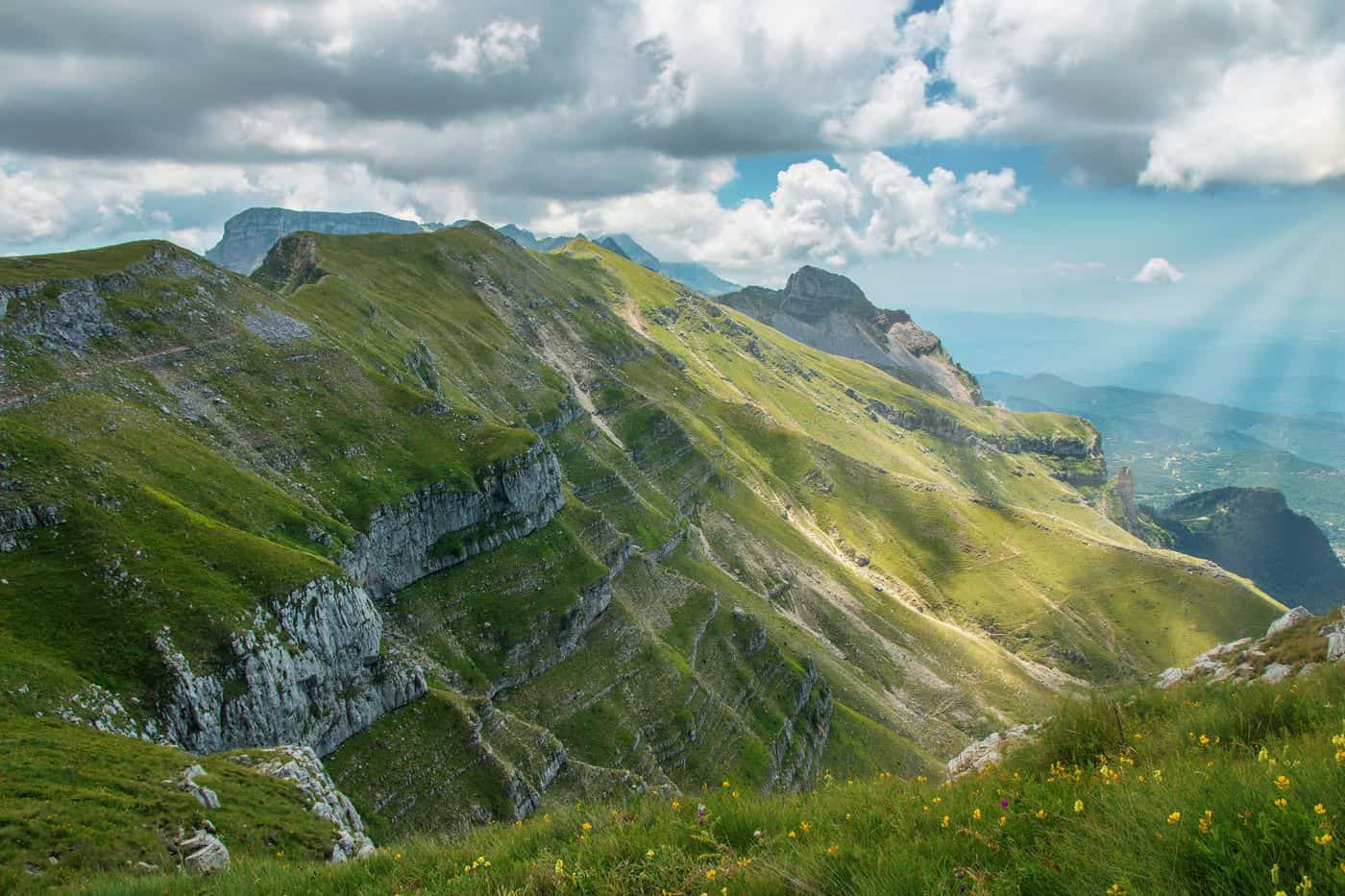
Tzoumerka tours start in the Athamanika mountains, the southern part of the Pindus range between the Arachthos and Achelous rivers, where stone villages and arched bridges sit on the borders of Ioannina and Arta. The routes cover Syrrako, Kalarrytes and Pramanta, the Kipina monastery and the Anemotrypa cave, the Plaka bridge and the Arachthos valley. Greece Tours lists the day trips and river tours that start in Ioannina and the Tzoumerka villages.
This page covers which villages Tzoumerka tours visit, the cave, the monastery and the bridges, the history of the area, the hikes, climbs and paragliding flights, the local food, how visitors reach Tzoumerka and which season suits each route. The tours below are checked on GetYourGuide and leave from Ioannina and the Arachthos river.
What do Tzoumerka tours cover?
Tzoumerka tours cover the Athamanika mountains, also called Tzoumerka, the southern part of the Pindus range. The range rises between the Arachthos and Achelous rivers, on the borders of Arta, Ioannina, Karditsa and Trikala, and peaks at Kakarditsa, 2,429 metres high.
The range runs about 40 km from north to south and 15 to 20 km from east to west. Its northern block, Kakarditsa, holds the highest summit. Tzoumerka tours on the Arta side reach the southern block, Tzoumerka proper, with Katafidi, 2,393 metres, as its top. The name Athamanika comes from the Athamanes, an ancient Greek tribe that flourished here in the 3rd and 2nd centuries BC. The name Tzoumerka is of Slavic origin and means hellebore.
Tzoumerka tours move between two municipalities named after the mountains. North Tzoumerka, in the Ioannina regional unit of Epirus, covers 358 square kilometres and has its seat at Pramanta. It was formed in 2011 from three former municipalities and four communities, Kalarrytes and Syrrako among them. Central Tzoumerka, in the Arta regional unit, has its seat at Vourgareli and joins Agnanta, Athamania, Melissourgoi and Theodoriana. The Tzoumerka villages and their settlements number 65: 33 in North Tzoumerka, 26 in Central Tzoumerka and 6 in the Trikala regional unit.
- Highest peak: Kakarditsa, 2,429 metres, between the villages of Matsouki, Melissourgoi and Athamania.
- Rivers: the Arachthos drains the west of the range, and the Achelous marks its eastern edge and separates it from the rest of the Pindus.
- Landscape: forests on the lower slopes, with grasslands, shrubs and bare rock higher up.
- Residents: the people of the mountains are called Tzoumerkiotes.
Tzoumerka tours cross a range listed among the Important Bird Areas of Greece.
Which villages do Tzoumerka tours visit?
Tzoumerka tours visit Pramanta, the largest village and seat of North Tzoumerka, the twin Vlach villages of Syrrako and Kalarrytes on either side of a deep ravine, and Agnanta, Melissourgoi and Theodoriana on the Arta side, in the municipality of Central Tzoumerka.
Three streams run through Pramanta and divide it into five quarters. The central square holds a perennial plane tree, the historic Arapis fountain and the church of Agia Paraskevi. Tzoumerka tours find the Anemotrypa cave and the Kipina monastery close to the village.
Syrrako has been a listed traditional settlement since 1978. Its stone houses carry slate roofs, and the old three-storey stone school is its largest building. Motor vehicles are not allowed inside, so Tzoumerka tours stop at the entrance, where a stone bridge joins the village to the modern road. Across the ravine, Kalarrytes stands at 1,150 metres and the whole village has also been listed since 1978. It flourished in the 18th century on trade and on silver and gold work, and Sotirios Voulgaris, founder of the Bulgari fashion house, came from the village.
The two are the only villages in the south of the Ioannina prefecture with this stone architecture, which is more common in the north, in the Zagori villages that Zagori tours cover. Tzoumerka tours on the Arta side reach four more villages.
- Agnanta: a dense village built like an amphitheatre at 642 metres, with houses of dark dressed stone and 449 residents in 2021.
- Melissourgoi: a village at 850 to 870 metres, recorded under this name, which means beekeepers, as early as 1272.
- Theodoriana: a village at 940 metres on the eastern slopes, near the Souda double waterfalls on the Aspri Goura river, 25 metres high.
- Vourgareli: the seat of Central Tzoumerka, at 760 metres, with the Byzantine Red Church from about 1280.
What do Tzoumerka tours see at the Anemotrypa cave and the Kipina monastery?
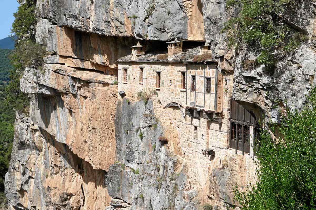
Tzoumerka tours see an underground river and a 250-metre visitor section at the Anemotrypa cave near Pramanta, and the Kipina monastery near Kalarrytes, built entirely into a vertical cliff above the Kalarrytikos river and dedicated to the Dormition of the Theotokos.
The story of Anemotrypa begins around 1960. The community president sent two young men, Apostolis Lambris and Georgios K. Karakostas, to open a crack that blew cool air, for a visit by Anna Petrocheilou, honorary president of the Hellenic Speleological Society. After crawling 10 metres, the two found a wide hollow. The cave has three levels, and Tzoumerka tours enter the middle one, opened to visitors. At the end of the tourist path, the river drops over a waterfall of 2 metres. Its water reappears at a spring in the gorge, 25 metres below the cave entrance.
Kipina is a monastery for monks. Old texts record its founding in 1212 by Archbishop Gregory, and another account credits monks from the Vyliza monastery in the 13th century. Kipina flourished in the 18th century, was abandoned in the 19th, and in 1931 became a dependency of the Tsouka monastery. Tzoumerka tours find its cells restored as a two-level complex with wooden elements.
- Cave lakes: three small lakes in shades of grey, pink and white under coloured stalagmites.
- Monastery access: a small path cut into the rock, with a wooden bridge as the main entrance.
- Main church: a small single-aisle basilica with a narthex and frescoes from the 17th century.
- Rock dome: the natural rock forms the roof of the church, carved into a regular dome.
- Iconostasis: carved wood with gilded inlay.
Tzoumerka tours reach Kipina on the road from Mystras to Kalarrytes. Mystras lies 12 km north of Pramanta.
Which stone bridges do Tzoumerka tours cross?
Tzoumerka tours cross the Plaka bridge over the Arachthos, built in 1866 with a single 40-metre arch, the largest single-arch bridge in Greece and the Balkans. Its arch collapsed in a flood on 1 February 2015, and the rebuilt bridge was completed in 2020.
Kostas Bekas, a master builder from Pramanta, finished the bridge in 1866, after earlier bridges on the site fell in 1860 and 1863, the second on its inauguration day. The Ioannina banker Ioannis Loulis and the nearby communities paid for the work. From 1881 to 1912 the bridge marked the border between Greece and the Ottoman Empire. Tzoumerka tours still see the customs building beside it. On 29 February 1944, the resistance groups EAM, EDES and EKKA signed the Treaty of Plaka near the bridge.
The National Technical University of Athens took on the restoration study. About 30% of the original material was recovered and built back in, and 35,000 dressed stones were used in all. The keystone was set on 4 December 2019, and the restoration received a Europa Nostra award in 2021. For Tzoumerka tours on the water, the bridge is the starting point for rafting and canoeing on the Arachthos, set out on the Tzoumerka rafting page.
- Politsa bridge: built in 1860 at the Politsa gorge of the Arachthos, linking the Katsanochoria with North Tzoumerka.
- Papastathi bridge: a four-arch bridge of 1746 over the Arachthos between Driskos and Anatoliki, built by Agapios, abbot of the Vyliza monastery.
- Gogos bridge: on the Kalarrytikos river between Raftanaioi and Michalitsi, where the river calms before its gorge.
- Koferitas bridge: a stone bridge on the Koferitas torrent at Melissourgoi, listed as a preserved monument in 2001.
Tzoumerka tours along the Arachthos follow a river with 55 stone bridges in all, the Bridge of Arta among them.
What history do Tzoumerka tours tell?
Tzoumerka tours tell the history of the Vlach, or Aromanian, villages, of the klephts and the 1821 Revolution, of the poet Kostas Krystallis, born in Syrrako, and of the National Park of Tzoumerka, Peristeri and Arachthos Gorge, which dates from 2009.
Aromanians lived in Syrrako before the 15th century. After 1480 the village was the capital of Malakasi, a self-governing federation of 42 villages, and its wool goods and capes reached trade centres of the Mediterranean and the Black Sea. Syrrako and Kalarrytes were the only villages in Epirus that joined the 1821 Revolution in its first year. Ottoman forces burned Syrrako on 10 July 1821, and the people rebuilt it between 1825 and 1828.
Tzoumerka tours in Syrrako stop at the home of Kostas Krystallis, born in the village in 1868. His patriotic poem Shadows of Hades brought persecution from the Ottoman authorities. He fled to Athens, and an Ottoman court sentenced him in absentia to 25 years of exile in Baghdad. He died of tuberculosis on 22 April 1894, aged 26. Since 2002 his family house has been a folklore museum and library.
- Klephts: the mountains were one of the largest centres of the Greek klephts and an armatoliki that produced Katsantonis, chief among its captains.
- Occupation: German operations in October 1943 burned 1,905 of about 6,000 houses in the Tzoumerka villages and killed 117 civilians.
- Peristeri: the highest peak of Lakmos, 2,295 metres, north of the Athamanika, with Syrrako on its slopes.
- Arachthos gorge: the Battle of Peta was fought in July 1822 on a height east of the gorge.
Tzoumerka tours today cross the National Park of Tzoumerka, Achelous Valley, Agrafa and Meteora, which spans 3,380 square kilometres. Its management body, founded in 2009, has its seat in Ioannina.
Which outdoor Tzoumerka tours hike, climb or paraglide?
Tzoumerka tours hike the paths between mountain villages, climb and abseil on high rock faces, cross gorges by canyoning and fly paragliders near Athamanio. Local outdoor firms also run flying fox crossings, archery, horse riding and mountain bike rides across the range.
The municipality of North Tzoumerka lists its best-known routes for Tzoumerka tours on foot. The path from Syrrako to Kalarrytes covers about 4.5 km through the Chrousias gorge, past old mills, in no more than an hour and a half. A mountain route links Matsouki, Vyliza and Kalarrytes in two hours. Trail T1 runs from Christoi to Kalarrytes or Syrrako, and trail T2 leaves the fir forest of Markopoulo for Raftanaioi and the Panagia Mouchousiotissa monastery.
On the Arta side, a path of about five hours joins Melissourgoi with Theodoriana. It crosses fir forests, springs, meadows, abandoned fields and sheepfolds, passes Afti at 1,750 m and looks out over Tzoumerka and the South Pindus. A shorter path climbs from Melissourgoi to a waterfall at about 1,500 m in about two hours.
- Climbing: trails around Athamanio suit mountaineering, and rock points above the village serve climbers.
- Paragliding: a paragliding competition site works 3 km from Athamanio, at an altitude of 960 m.
- Canyoning: descents run through the Papadima gorge near Charokopi and the Klifki gorge below Kalentzi, with ropes, climbing gear and special water suits.
- Mountain biking: rides cross the pine forest on Faneromeni hill, climb to Profitis Ilias at Kostitsi, with a panoramic view of the meeting of the Kalarrytikos and the Arachthos, and reach the abandoned village of Mega Ampelia.
- Rafting: kayak and rafting descents run on the Arachthos all year, and the 13 km stretch down to the Plaka bridge takes three hours.
Tzoumerka tours on the Arta side also use Katarraktis as a base for short and long hikes. On the way up to its waterfalls, the Kastri height, at about 1,600 m, looks out over the Ambracian Gulf and the Ioannina basin.
What do Tzoumerka tours taste?
Tzoumerka tours taste pies, local dairy, roast meat, honey and tsipouro. The pie list runs from milk pie and meat pie to blatsaria, trahanopita and cheese pie, because pies were the staple food of the nomadic herders and Vlachs of Epirus.
The full range of pies in the area takes in galatopita, kolokythopita, kourkoutopita, kreatopita, katharopita, lachanopita, makaronopita, blatsaria, ryzopita, trahanopita and tyropita. Athamanio makes its pies from greens or with milk, and its sweets rest on flour and walnuts.
Livestock farming shapes the menu of Tzoumerka tours. Athamanio is known for its roasts and meat recipes. It produces dairy goods and local cured meats, and it harvests and packs walnuts. Epirote cooking rests chiefly on dairy products, butter and cheese. Kefalograviera, a hard cheese of sheep’s milk or of sheep’s and goat’s milk with PDO status, is made in Epirus, Western Macedonia, Aetolia-Acarnania and Evrytania, and traditional feta also appears among the products of Tzoumerka. Village cafés and grills serve tsipouro, local wines, traditional recipes and select meats.
- Honey: beekeeping has grown at Athamanio, and Kryoneri counts honey among its notable products.
- Tsipouro: the zabela grape, a hardy dark hybrid, thrives in Tzoumerka and suits tsipouro rather than wine.
- Wine: a winery and distillery at Platanousa, on walking trail A1, grows Debina and Malagousia among other grapes.
- Herbs: oregano, chamomile and mountain tea, plus thyme gathered at Athamanio.
- Pantry goods: trahanas, hilopites noodles, spoon sweets, chestnuts, walnuts and the figs called pasmadia.
Sweet stops on Tzoumerka tours include a pastry workshop in Pramanta that bakes koulourakia, tarts, ravani and skaltsounia, and a shop in Syrrako that sells sweets, local products and herbs.
How do visitors reach Tzoumerka for Tzoumerka tours?
Tzoumerka tours start by road from Ioannina or Arta. Pramanta lies 65 km southeast of Ioannina and 70 km northeast of Arta, Ioannina National Airport sits 4 km from the city centre, and intercity KTEL buses from Arta serve the mountain villages.
From Ioannina, base of Ioannina tours, three routes lead into the range. The 2nd provincial road passes the Katsanochoria villages to the Elliniko junction, then Kalentzi, and crosses the Plaka bridge to Pramanta. The 3rd provincial road heads for Koutselio and over the Tsimpovo bridge to Kalarrytes, Syrrako and Matsouki. A third choice turns off after the Elliniko junction for Ampelochori via the Politsa bridge. Kalarrytes lies 56 km southeast of Ioannina, and Chouliarades lies 32 km from the city.
Visitors on Arta tours reach the northern villages by the road for Rodavgi and Platanousa, which starts right after the Bridge of Arta. Katarraktis lies 50 km from Arta and 54 km from Ioannina, and Athamanio lies 64 km from Arta, about 50 minutes on the new Arta–Trikala road. National Road 30, from Arta to Trikala, Karditsa and Volos, is the only major road across the Athamanika range. Provincial roads via Chrysomilia, Kleino, Mourgkani and Neraidochori open Tzoumerka tours to drivers from Thessaly.
- By air: Ioannina National Airport, named King Pyrrhus (IOA), and Aktion airport both serve the Arta area.
- By bus: the intercity KTEL Arta station stands on the Arta ring road, 1 km from the centre, with daily routes to Ioannina, Preveza, Athens, Thessaloniki, Patras and Larisa.
- From Athens: the road distance to Ioannina is about 410 km.
- From northern Greece: drivers leave the Egnatia Odos at the Ioannina/Tzoumerka exit, the first one after the Drosochori toll station.
- From Metsovo: Pramanta lies 28 km south of Metsovo, the base for Metsovo tours.
When do Tzoumerka tours run best?
Tzoumerka tours run best from spring to autumn. The mountain areas have a continental climate with cold, sometimes long winters and summers with local rain, and the village festivals take place almost only in summer, each tied to a church feast.
Moist air from the Ionian Sea unloads its rain on the Pindus, and yearly rainfall on the Tzoumerka massif tops 2,600 mm. In 2010, the weather stations of the National Observatory of Athens placed Theodoriana, with 2,887 mm, and Katarraktis, with 2,750 mm, among the five wettest areas in Greece. Ioannina, the main gateway, is the wettest city in mainland Greece with over 50,000 inhabitants, and its winters bring frequent frosts.
Kalarrytes has a harsh, long winter, a short spring, a warm summer rich in rain and a long autumn. In spring, the twin waterfalls above Katarraktis, 87 m and 100 m high, fall at full force, a goal for Tzoumerka tours on foot along a stone path.
- 20 July: Lepiana holds a three-day festival for Profitis Ilias.
- 26 July: Kalarrytes celebrates Agia Paraskevi at a cave chapel at 1,750 m, 6 km outside the village, then carries the feast into the village square.
- Early August: the Arachthio Theatre of Tzoumerka festival fills the small open-air stage at Palaiochori Skoupas, a fixture since 2006.
- 15 August: Katarraktis holds a three-day festival, and everyone in the central square dances the Kangelari, also called Bairaktaris.
- 7–9 September: Chouliarades honours the Virgin Mary with a three-day festival, and on the third day villagers sing the Kangelari circle dance without instruments.
Kalarrytes also fills its central square for a large festival on the evening of 15 August, with guests from the Tzoumerka villages, Ioannina, Thessaly and Athens. Autumn brings the chestnut and tsipouro festival to Rodavgi in mid-October, on the road from Arta to the northern villages, with roast chestnuts, tsipouro and local dishes. On Carnival Sunday, the larger villages hold masquerades and light traditional bonfires known locally as Depo.
Frequently Asked Questions
Where do Tzoumerka tours spend the night on the mountain?
Tzoumerka tours on the Arta side use the stone mountain refuge of Katarraktis, at 1,670 m. It bears the name of Ioannis Tsamakos, a pioneer of Greek mountaineering born in the village, sleeps 40 people and serves drinks, meals and breakfast. In the north, a second refuge stands at Isioma in Pramanta.
Do Tzoumerka tours run in winter?
Tzoumerka tours continue in winter at the snow park of Isioma in Pramanta. It is a small, eco-friendly activity park open 365 days a year rather than a full ski centre, and it sits next to the Pramanta mountain refuge with Strongoula peak behind it. The North Tzoumerka municipality also promotes trips at Christmas.
What wildlife do Tzoumerka tours spot?
Tzoumerka tours share the slopes with deer, roe deer, wolves, bears, wildcats and badgers, along with partridges, hoopoes, eagles and golden eagles. Near Elliniko, kestrels nest in rock hollows, and short-toed snake eagles, buzzards and tawny owls hunt over the evergreen forest of kermes oak, juniper, holm oak and laurel.
Which Tzoumerka tours suit beginners?
Tzoumerka tours cover every age, from adventure lovers to visitors who want a new experience, according to the North Tzoumerka municipality. Archery gives a mild option, with firms that supply a professional target, bows and arrows. Harder ground lies on the four-hour climb from Matsouki over Strongoula peak to the Isioma refuge, a route rated difficult.