
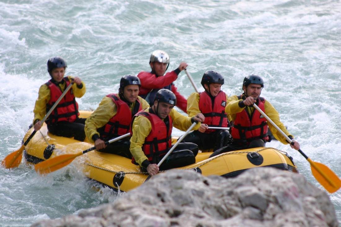
Tzoumerka rafting runs down the Arachthos river from the single-arch stone bridge at Plaka, through a gorge of rock walls and riverside woods in the mountains of Epirus, with a guide in every raft and helmets, life jackets and wetsuits for the whole crew. Plan the rest of the trip with Greece Tours.
This page covers the rafting: the river, the bridge, the gorge, the guides and the safety routine, who can join, the seasons and water levels, the villages and food around it, and how a rafting day is planned.
What is Tzoumerka rafting?
Tzoumerka rafting is a guided river descent on the Arachthos in Epirus. Guests ride inflatable rafts from the Plaka bridge down the river towards Tzari. Every guest wears a helmet and a life jacket, and a qualified guide steers each raft.
The Arachthos runs through the Tzoumerka area and goes south towards Arta. The river forms a natural path through the valley.
The route begins at an old single-arch stone bridge over the water. Rafting and canoeing on the Arachthos start at this crossing.
The river passes between steep sides and rock walls. Riverside woods line the banks in places, and the view stays close to the water for the descent.
Where are the mountains of Tzoumerka rafting?
Tzoumerka, also called the Athamanika mountains, is a mountain range in Epirus in north-western Greece. It lies on the border of the Ioannina and Arta regional units. The Arachthos runs through the area and continues south towards Arta.
Syrrako stands in North Tzoumerka. It is a stone village of the Aromanian (Vlach) community.
The range touches the Ioannina and Arta regional units. The river valley lies on the border where the mountain ground falls away towards the water.
The mountains give the river its steep banks and narrow sections. Rock walls rise close to the channel on parts of the route.
Which river does Tzoumerka rafting use?
Tzoumerka rafting uses the Arachthos river. The watercourse runs through the Tzoumerka area and continues south towards Arta. A bookable route follows it from the Plaka bridge down towards Tzari.
The river cuts a gorge with steep sides and rock walls. The channel narrows between the mountains on the way downstream.
Riverside woods line parts of the channel. The water moves between shaded banks and open current.
The launch point sits on the border between the Arta and Ioannina prefectures. The bridge is the starting point for rafting and canoeing on the Arachthos.
Where does a Tzoumerka rafting route start?
A bookable Tzoumerka rafting route begins at the Plaka bridge and runs down the Arachthos towards Tzari. The bridge serves as the launch point.
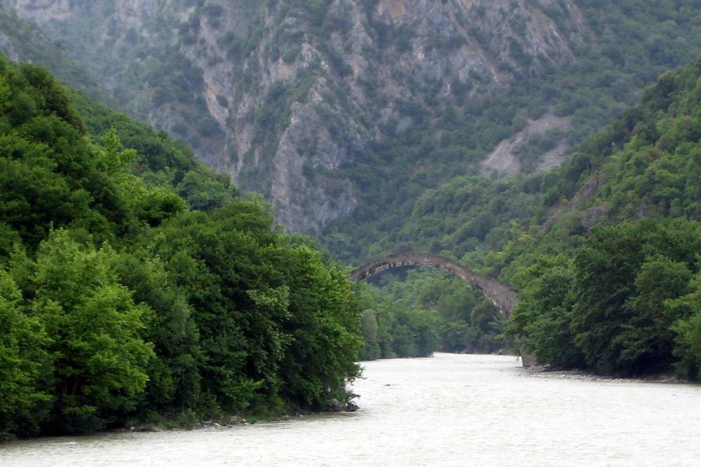
The Plaka bridge is a nineteenth-century single-arch stone bridge over the Arachthos. The crossing holds one wide central arch above the river.
The crossing is the meeting point of two prefectures. Boats enter the river next to the old stonework, and the route follows the current away from the arch.
The route leaves the bridge and follows the current downstream. The first part of the descent faces the gorge walls and the riverside woods.
How was the Plaka bridge of Tzoumerka rafting built?
The Plaka bridge was built on the order of the Ottoman sultan Abdulaziz. The single-arch stone bridge spans the Arachthos in one leap. It was built in the nineteenth century.
The central arch is 40 metres wide and about 17.6 metres high. The opening spans the river in one clear line.
Two small side arches of 6 metres sit beside the main opening. They frame the central arch on the river crossing.
The bridge uses local stone and a single wide span. The arch crosses the river under the mountain slopes.
What happened when the Plaka bridge collapsed and how was it rebuilt?
The Plaka bridge collapsed in a flood and has been rebuilt. The stone arch now spans the river again. The reconstruction brought back the single-arch form.
The central arch and the side arches were restored after the flood. The masonry was rebuilt at the same river crossing, and the structure stands again above the water.
The rebuilt crossing remains the launch site for rafting and canoeing. Boats gather downstream of the stonework before the descent.
Visitors see the masonry from the bank before the trip. The bridge marks the border between the Arta and Ioannina prefectures.
What does the gorge look like on Tzoumerka rafting?
The Arachthos flows through a gorge with steep sides, rock walls and riverside woods. From the raft, the channel feels narrow and the green banks rise close to the water. Wet stone appears along the edges.
Rock walls stand above parts of the current. The boat passes close to dry and wet faces, and the high sides block the outside view.
Trees line the water where the gorge opens a little. Their shadows fall over the surface and cool the air near the bank.
The route passes the old bridge soon after launch and then moves downstream. The walls guide the river around bends and past wooded banks.
Who guides the rafts on Tzoumerka rafting?
A qualified guide steers each raft on the river. The guide controls the direction, sets the pace and keeps the group together through the gorge. Every guest wears a helmet and a life vest.
The guide gives commands for paddling in the current. Guests follow the same rhythm so the raft moves as one unit.
Safety checks are done before the raft enters the water. The guide inspects the gear on the bank and fixes anything loose.
Paddle practice happens on the shore before launch. Each person learns the basic stroke and the signal to stop paddling.
What safety kit is worn during Tzoumerka rafting?
Every participant wears a helmet and a life jacket. A wetsuit is supplied when the water is cold, and the guide checks each piece before the trip begins. The kit stays on for the whole descent.
The helmet protects the head near rock walls and low branches. It sits snug on the head for the whole trip.
The buoyancy vest keeps the body afloat in moving water. It fits over the upper body and stays secured with straps.
The wetsuit adds a warm layer on cold river days. The material holds heat close to the skin when the air or water is cold.
What happens in the briefing before Tzoumerka rafting launch?
A safety briefing and paddle practice come before launch. The guide explains basic commands, how to sit in the raft and how to paddle as a group. Each guest gets the same instructions at the river bank.
The guide shows how to hold the paddle with both hands. The group repeats the stroke together and learns the command for forward motion.
Body position and foot support are checked on the shore. This keeps each person stable in the boat during the moving sections.
The rafts enter the water after the group finishes the practice. The guide gives a final signal from the bank, and then the trip leaves the shore.
Who can join Tzoumerka rafting?
Rafting operators set a minimum age for the trip. Guests do not need previous river experience, but they need to listen to the guide and follow safety instructions. The activity is open to beginners.
Children join when they meet the operator’s age rule. The minimum age is fixed by the rafting company.
Adults sit in the raft and paddle with the group. The guide handles the steering from the stern.
No guest has to read the river. The guide makes the route decisions on the water and sets the pace.
What do you wear and bring for Tzoumerka rafting?
Wear clothes that can get wet and footwear that stays on the feet. Bring a towel and dry clothes for after the trip. The operator supplies the helmet and the life vest, and a wetsuit when the water is cold.
A swimsuit or quick-dry layer works under a wetsuit. The layer sits close to the skin and moves with the body.
Cotton layers hold water and feel cold. Pick a fabric that dries fast and stays light.
Leave loose jewellery and heavy bags at the base. Secure glasses with a strap if worn on the river.
How long does Tzoumerka rafting last on the water?
The on-water time depends on the river current and the pace of the group. The bookable descent runs from the Plaka bridge down the river towards Tzari. There is no fixed minute count for the river.
The route follows the natural flow through the gorge. The water level shapes the speed of the descent.
Calm floats and faster stretches alternate along the water. The guide reads the current and sets the rhythm for the group.
The group gathers in slow water before the next moving part. Rest breaks happen at safe spots where the bank allows the boats to stop.
Which season suits Tzoumerka rafting?
The river character changes with the water level, so operators run trips when conditions allow safe passage. A wetsuit is supplied when the water is cold. The bookable session appears on GetYourGuide.
The bookable trip on GetYourGuide runs on days when the operator confirms the river is open. Booking works for the advertised activity.
Cold air and water make the neoprene layer an important part of the kit. It holds body heat close to the skin.
The stone bridge and the gorge stay accessible to visitors. The river level decides the on-water plan.
How does Tzoumerka rafting compare with rafting in Zagori?
Tzoumerka rafting runs on the Arachthos from the Plaka bridge towards Tzari. Rafting in Zagori runs on another river, and one bookable tour combines Epirus and Zagori with viewpoints and lunch.
The Tzoumerka route stays near the stone villages of North Tzoumerka. Syrrako is one of those villages in the Aromanian community.
A different river trip is available through Voidomatis river rafting. It follows the flow in the Zagori area.
The Epirus and Zagori rafting tour with viewpoints and lunch is bookable on GetYourGuide. It covers another river outside the Arachthos.
How do you reach Tzoumerka rafting from Ioannina and Arta?
Tzoumerka lies on the border of the Ioannina and Arta regional units, and the Plaka bridge stands on the border between the prefectures. The river valley is reached from both sides of the range. The Arachthos runs south towards Arta.
The Arachthos river course passes through the Tzoumerka area and continues south towards Arta. The mountain range sits in Epirus in north-western Greece.
The bridge is the meeting point for rafting and canoeing on the Arachthos.
For travel from the city, Ioannina tours offers ways to explore the area. The route map starts from the regional capital.
What does paddling in a Tzoumerka rafting boat involve?
Paddling in a raft is a team effort. The guide calls the strokes and the crew paddles together forward or back. Every paddler digs the blade into the river at the same time. The raft turns and moves as one unit.
The guide sits at the back and watches the line. The crew listens for short calls that set the rhythm. Each forward stroke has a reach, a pull and a lift.
A backward stroke slows the boat or pulls it away from a rock. The crew stops together when the guide drops the call. Team timing matters more than power.
On moving water the paddle turns into a brace. The guide uses a paddle as a rudder. The raft turns only when everyone keeps the same beat.
How many people fit in a raft on Tzoumerka rafting?
Rafts carry between four and eight guests plus the guide, depending on the boat. The boat size sets the group size. A smaller raft turns faster on the river. A larger raft tracks with more weight through waves.
Each guest takes one side of the boat. The guide sits in the centre or at the rear. The crew fills the boat evenly so the balance stays level.
A raft for four sits low on the water. It moves quickly and needs sharp timing from every paddler. A raft for eight spreads the effort across more people.
The guide chooses the boat before the trip. The river level and the group size decide the craft. This keeps the boat steady in the current.
What happens on the calm stretches during Tzoumerka rafting?
On calm stretches the guide lets the group swim or float beside the raft when conditions allow. The boat drifts slowly through flat water. People leave the raft and enter the river for a short break.
The guide checks the current before anyone enters the water. The raft stays close by. Guests hold a line or a grab loop if the boat moves.
Floating beside the raft cools the body after the effort of paddling. A swimmer lies on the back and watches the high slopes above the river.
The guide calls everyone back before the next rapid. A flat-water pause ends at a bend or a narrow section. The group climbs aboard and takes paddles again.
How do water levels change Tzoumerka rafting through the year?
Water levels are higher in spring after the snow melts and lower in late summer. The river swells with snowmelt from the peaks. Late summer brings low, clear water that exposes more boulders.
Spring flow moves fast and pushes the raft through the gorge with less paddling. The river feels full from the high peaks of Tzoumerka.
Late summer lowers the flow to a slower pace. The guide reads the exposed rocks and picks narrow channels. Low water makes the trip more technical.
The river changes between these two points. A trip in early spring has deep waves. A trip at the end of summer has a calmer character.
Where does the Arachthos river end?
The Arachthos river ends in the Ambracian Gulf south of Arta. The river leaves the mountains and crosses a wide plain before it reaches the sea. Fresh water mixes with salt water there.
The river mouth lies south of the city of Arta. The gulf receives the flow at the end of the river’s course.
Arta sits upstream from the river mouth. The old stone bridge of Arta crosses the Arachthos inside the city.
The gulf is a coastal sea inlet. The Arachthos links the Tzoumerka mountains to this sea through the city of Arta.
What is the old bridge of Arta and its ballad?
Arta is known for its old stone bridge over the Arachthos, the subject of a Greek folk ballad about the builder who walled his wife into the foundations. The bridge stands in the city on the river.
The ballad tells of a construction that kept falling until the builder placed his wife in the stone. The song is one of the best-known folk tales of Epirus.
The bridge has strong stone arches that have lasted through many floods. It remains a landmark in Arta and a link to the river’s past.
Rafters see the same river that runs under the old bridge. The ballad connects the water to the people who built across it. The story adds weight to a drive through Arta.
What stone villages sit near Tzoumerka rafting?
The Tzoumerka villages are built of grey stone with slate roofs, set on steep slopes above the river valleys. Their houses rise from narrow roads and stone walls. The mountains surround each cluster of homes.
Grey stone walls hold the hillsides in terraces. Slate roofs reflect the same colour as the rocks. The buildings sit tight against the slope to resist wind and rain.
Village lanes twist through the houses and open on small squares. A few stone steps lead from one level to the next. The river valley lies far below the edge of the village.
The stone work remains plain and solid. The view from a village opens over high ridges and deep river gorges. Each settlement sits close to the slope.
Why is Syrrako different from other Tzoumerka villages?
Syrrako, an Aromanian village, has stone lanes, stone houses and no cars in its centre. The village keeps its old shape without traffic. People walk through the lanes and step over stone thresholds.
The centre is reached on foot. Cars stop outside the stone core of the village. This lack of engines keeps the lanes quiet and clear.
Syrrako has an Aromanian heritage. Its old houses show the same grey stone as the other Tzoumerka villages. The roofs step down the slope in tight rows.
Stone lanes link the houses and small walled paths. The streets are too narrow for cars. A walk through Syrrako gives a close look at mountain stonework.
What smaller stone bridges stand near Tzoumerka rafting?
The mountains hold stone arch bridges over the side streams as well as the Plaka bridge. These smaller spans cross tributaries that feed the Arachthos. Each arch rises from the streambed in a single curve.
Stone masons built these bridges with local grey rock. The arch carries a narrow path from one bank to the other. A side stream runs beneath through a rocky bed.
These structures sit away from main roads. A hiker finds them on old paths that link Tzoumerka villages. The bridges mark former trade and herding routes.
The Plaka bridge is the largest of the river crossings. The side-stream bridges are smaller but use the same arch form. Together they form a network of stone over water.
What else can you do around Tzoumerka rafting?
Other outdoor activities in the Tzoumerka area include hiking on mountain paths, canyoning in side gorges and kayaking on the river. These options extend a trip beyond the inflatable raft.
Hiking paths climb from village to village and cross stone bridges over streams. The trails stay high above the Arachthos and open onto bare mountain ground.
Canyoning follows the side gorges that cut into the Tzoumerka mountains. Guides lead descents through cold pools and narrow rock walls.
Kayaking on the Arachthos gives a single paddler a closer line through the waves. The same river that carries rafts also suits a lighter craft.
What do you eat after Tzoumerka rafting?
Tavernas in the villages serve mountain food: pies, grilled meat, local cheeses and trout from the rivers. A warm meal after a river trip restores energy. The dishes come from the farms and waters of Epirus.
Pies come in large round trays with flaky crust. Local cheeses range from soft white cheese to hard aged rounds. Bread and olives sit beside the plates.
Grilled meat from the mountain villages cooks over an open fire. The stone rooms fill with warm air and the scent of the grill. A plate of grilled meat arrives hot on the table.
Trout from the rivers is cooked whole and served with lemon. The side streams and the Arachthos supply the fish. A mountain taverna meal closes the day with strong local flavours.
Why does Epirus suit a Tzoumerka rafting trip?
Epirus is one of the most mountainous and least crowded regions of Greece. The Arachthos runs through deep valleys and quiet country. Rafting here feels removed from busy coasts and cities.
The mountains of Epirus create steep river gradients and fast water. The region’s relief feeds the Arachthos with snowmelt and side streams. A raft trip finds clean, cold flow.
Low visitor numbers keep the river and the villages calm. The roads climb slowly into a landscape of stone and high ridges. A rafting day here does not pass through crowds.
The plain of Arta and the Ambracian Gulf lie below the mountains. After the gorge, the river spreads into an open lowland. This contrast between mountain and sea defines the region.
How do you plan a full day around Tzoumerka rafting?
A full day pairs the raft trip with a village stop and a meal. Begin with the river, drive into the stone villages after, and finish with taverna food. The mountains hold all parts of the day.
Start with the river trip early in the day. The flow through the gorge sets the pace. The raft trip fills the morning hours.
After the river, drive up to a Tzoumerka village. Walk the stone lanes and see the slate roofs. A stop at a stone bridge over a side stream adds a short walk.
End the day at a taverna in the mountains. Eat a pie or grilled meat with local cheese. The drive back leaves the high slopes and returns to the lowland plain.
How does a Tzoumerka rafting day start at the base?
A Tzoumerka rafting day starts at the operator’s base near the river. The group meets there, changes into the supplied kit, and then rides to the launch point together with the rafting team. The start is organised before any time on the water.
The operator’s base sits near the river. It is the fixed meeting point for the group, and it keeps the start organised before the drive.
Everyone changes into the supplied kit at the base. The change happens on land before the drive to the river, so the group starts the day ready.
The group rides to the launch point together. The ride leaves after everyone has put on the kit, and the group does not split up for the transfer.
What happens to phones and cameras on Tzoumerka rafting?
On a Tzoumerka rafting trip, phones and cameras stay in waterproof bags or in the vehicle. They stay out of the river water. Some operators carry a camera on the raft and share the pictures afterwards. The devices stay dry.
Phones and cameras go into waterproof bags before the raft moves. The bags keep river water away from the devices during the trip.
Devices can also stay behind in the vehicle at the base. The vehicle keeps them off the raft and away from the water.
Some operators take their own camera on the raft. They share the pictures with the group after the trip, and the group receives them later.
How cold is the water on a Tzoumerka rafting trip?
The water on a Tzoumerka rafting trip is cold even in summer. Mountain streams feed the river, and that flow keeps the water cold through the warm season. The cold is present even on hot days. The river does not warm up in summer.
Mountain streams feed the river. The streams flow from the mountains into the river, and their water keeps the river cold.
The water is cold even in summer. The cold stays through the warm months, and the river stays cold on hot days.
The cold water comes from the mountain streams. Their flow keeps the river temperature low during the whole summer.
Who books Tzoumerka rafting?
Groups of friends, families with older children, school groups and company teams all book Tzoumerka rafting days. These group types all take part in the rafting day on the river. Each group type books a place on the river.
Groups of friends book rafting days. They take part as a group.
Families with older children book rafting days. They take part as a family group.
School groups and company teams also book rafting days. These groups take part in the same river activity.
Can non-swimmers join Tzoumerka rafting?
Non-swimmers can join Tzoumerka rafting. Swimmers and non-swimmers both take part because the life jacket keeps everyone afloat on the river. The same safety kit works for all people. The life jacket is the main support in the water.
Swimmers and non-swimmers both take part on the same trips. No person is left out because of swimming ability.
The life jacket keeps everyone afloat. It holds a person up in the river water and gives support during the trip.
Non-swimmers join the rafting day. The life jacket makes their place on the raft safe, just as it does for swimmers.
How does rain change a Tzoumerka rafting day?
Rain upstream changes a Tzoumerka rafting day. The river rises within hours of upstream rain. Operators check the water level each morning and choose the section to match that level. The plan follows the morning check. The river level decides the section.
Upstream rain raises the river within hours. The water level can climb fast after rain, and the change comes from far up the river.
Operators check the water level each morning. They do this before the group starts the day, and the check sets the plan.
The section for the day is chosen to match the water level. The river section fits the conditions found that morning.
Frequently Asked Questions
Which river does Tzoumerka rafting use?
The Arachthos, starting at the Plaka bridge.
Do you need rafting experience?
No. Beginners join the same trips after a safety briefing and paddle practice.
Can non-swimmers take part?
Yes. Everyone wears a life jacket and a helmet for the whole trip.