
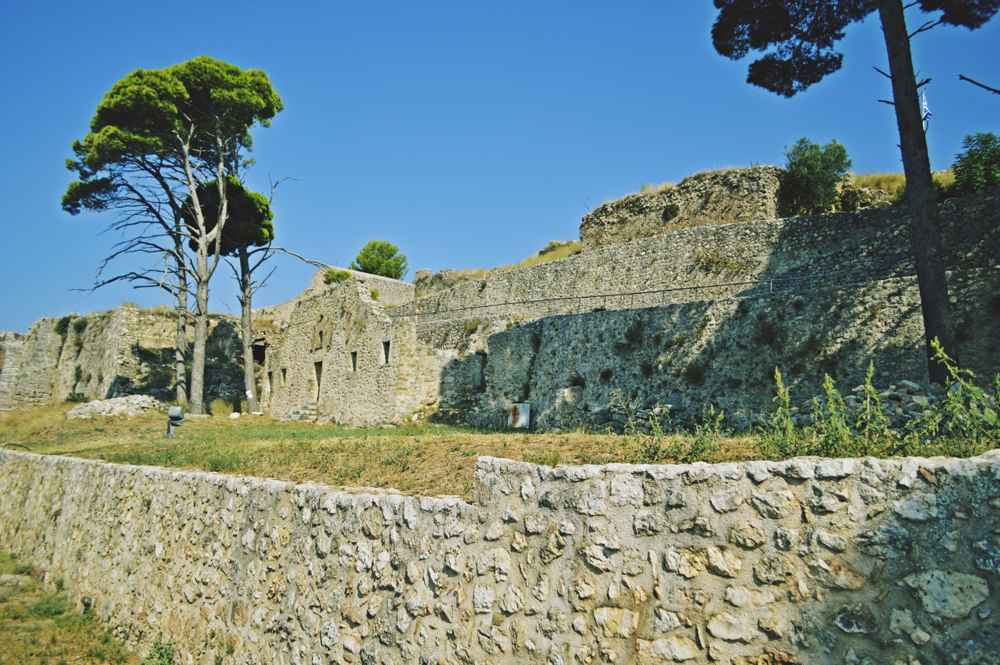
The Castle of Saint George, known in Greek as the Kastro or the fortress of Agios Georgios. Crowns a hill of roughly 300 metres above the village of Peratata in the Livatho plain. It sits about 7 km southeast of Argostoli, the modern capital of Kefalonia, the largest of the Ionian islands. First raised by the Byzantines and rebuilt by the Venetians around the year 1500, the fortress guarded the island for centuries. Until 1757 the walled town inside it served as the capital of Kefalonia, home to several thousand people. Its polygonal ramparts, gates and bastions still command wide views across the plain toward Argostoli and the sea. Plan the whole trip with Greece Tours.
The castle stands as a ruin, much of it thrown down by the earthquake of , yet the outline of the medieval capital remains legible within the walls. Cisterns, the carved Venetian Lion of Saint Mark above a gate, and the remains of churches including the Evangelistria mark the ground where a whole town once lived. Below the ramparts the small village of Kastro keeps its traditional houses, cafes and tavernas, and paths climb from the car park to the entrance. The Agios Andreas monastery at Milapidia and the Robola vineyards of the Omala valley lie a short distance away, gathering castle, monastery and vineyard in one corner of the island.
What is the Castle of Saint George in Kefalonia and where does it stand?
The Castle of Saint George is a Venetian-era hilltop fortress above the village of Peratata in the Livatho plain. It stands on a hill of roughly 300 metres, about 7 km southeast of Argostoli.
The fortress occupies the summit of a low mountain that rises from the Livatho, the fertile southern plain of Kefalonia. From this height of about 300 metres the walls look down on cultivated fields, olive groves and scattered villages, with the sea visible beyond. Peratata lies directly below the northern slope, while Argostoli, the present capital, sits roughly 7 km to the northwest around the sheltered gulf. The position was chosen for defence, a single fortified hill controlling the approaches to the richest farmland on the island. Its command of land and sea made it the natural seat of power for centuries of the island’s history.
In shape the castle forms an irregular polygon, its curtain walls following the contours of the rock and reinforced at the corners by projecting bastions. Three gates once pierced the circuit, and the main entrance still carries the relief of the Lion of Saint Mark, the emblem of Venice. Within the enceinte lie the ruins of the medieval town, a dense grid of houses, streets, churches and cisterns now reduced to low walls and foundations. The whole enclosure covers a compact area, small by the standard of great mainland fortresses, yet large enough to hold a working town of several thousand residents behind its ramparts.
The name Agios Georgios, Saint George, attaches both to the fortress and to the village of Kastro that grew beneath it. Local usage often calls the site simply the Kastro, the castle, since for generations it was the castle of the island without need of further name. The hill it crowns separates the Livatho from the neighbouring valleys, and the Robola vineyards of the Omala basin lie a short way inland. The airport of Kefalonia occupies the coastal flat to the south, so aircraft on approach pass within sight of the ramparts, a modern note beneath the medieval stone of the walls.
Reaching the castle involves a short climb from the village. A road winds up from Peratata and the Argostoli direction to a car park near the foot of the walls, and from there a stone path rises to the gate. The ascent is modest, a matter of minutes on foot, and rewards the effort with the full circuit of the ramparts. The site stands open to the air, its towers roofless and its churches broken, so the visit is one of walking among ruins rather than through restored halls. The ground underfoot is uneven, and stout footwear serves the walk well.
What are the Byzantine and Venetian origins of the fortress?
The fortress began as a Byzantine stronghold, its first walls raised in the Middle Ages. The Venetians took the hill and rebuilt it around the year 1500, giving the castle its present polygonal form with bastions and gates.
The earliest defences on the hill are Byzantine, part of the fortified network that guarded the Ionian islands during the Middle Ages. Byzantine builders exploited the natural strength of the summit, ringing it with walls of stone quarried close at hand. Over the medieval centuries the stronghold changed hands amid the shifting fortunes of the region, passing among the powers that contested the Ionian Sea. By the late fifteenth century the fortress had become the principal seat of authority on Kefalonia, its walls enclosing a town that served as the administrative heart of the island. The Byzantine core set the pattern that later rulers enlarge and strengthen.
The Venetians took control of Kefalonia and rebuilt the castle around the year 1500, and it is their work that shapes the fortress seen today. They recast the enceinte as a polygon braced by angular bastions, a design suited to the age of gunpowder and cannon. New gates were cut through the walls. Above the principal entrance the masons set the Lion of Saint Mark. The winged emblem that marked Venetian possession across the Adriatic and Ionian. The Republic held the island for the following centuries, and the castle remained the fixed point of its rule, garrison and government combined on one commanding hill.
Under Venetian administration the fortified town within the walls flourished as the capital of Kefalonia. Houses, churches, storehouses and cisterns filled the enclosure, and the population climbed into the thousands. The cisterns collected rainwater for the community, a necessity on a dry summit without a spring, and their vaulted chambers still survive among the ruins. The churches served the religious life of the town, the Evangelistria among them, and their remains mark the devotion of the medieval community. The Lion over the gate proclaimed the authority of Venice to everyone who passed beneath it, a carved statement of who governed the island for those long centuries.
The military logic of the site held firm through the Venetian period. From the ramparts the garrison watched the Livatho plain, the road toward Argostoli and the sea lanes beyond, ready to signal or resist any threat. The polygonal trace, with its bastions covering the walls between them, reflected the current science of fortification, adapting the medieval circuit to withstand artillery. Successive works of repair and reinforcement kept the defences current across the long span of Venetian rule. The castle thus carries two clear layers in its stones, a Byzantine foundation and a Venetian superstructure, the one enclosed and preserved within the other on the height.
Why was the castle the capital of Kefalonia until 1757?
The castle was the island’s capital because its walls offered the safest and most defensible seat of government. The capital remained there until 1757, when it moved down to the harbour town of Argostoli.
For much of the medieval and early modern period the safest place on Kefalonia was behind walls on high ground, and the Castle of Saint George offered exactly that. Coastal towns lay open to raids from the sea, while a fortified hill some distance inland gave shelter and control together. The castle commanded the Livatho, the island’s richest farmland, and stood within reach of the western gulf without sitting exposed upon it. Government, garrison and a large part of the population gathered inside the enceinte, making the fortress the administrative. Military and social centre of the island for generation after generation of its people.
Life inside the walls was that of a compact town rather than a mere garrison. Several thousand people lived within the enclosure at its height, in houses ranged along narrow streets between churches and public cisterns. Officials of the ruling power kept their seats there, courts sat, and the trade and craft of the island passed through its gates. The density of building within so small a circuit speaks to the value placed on the protection the walls afforded. For the people of the Livatho and beyond, the Kastro was the town, the place of authority, refuge and market alike across the centuries of its rule.
By the middle of the eighteenth century the balance had shifted. The danger from seaborne raids had receded. The cramped hilltop, with its steep approach and its dependence on stored rainwater, suited the growing needs of the island less and less. Argostoli, spread along a sheltered inlet with a harbour and room to expand, drew trade and settlement toward the water. Commerce favoured the port, and administration followed where the people and the money moved. The advantages that had once made the hill indispensable turned, in changed conditions, into the disadvantages of distance from the sea and the market of the growing town.
In 1757 the capital of Kefalonia moved from the castle down to Argostoli, and the fortified town on the hill began its long decline. The seat of government, the courts and much of the population drifted to the harbour, leaving the walls to a shrinking community and the slow work of time. Argostoli grew into the modern capital that holds the role still, roughly 7 km from the fortress that preceded it. The castle passed from living capital to monument, its streets emptying and its houses falling, though its walls and gates endured on the height as a record of the centuries when it ruled the island.
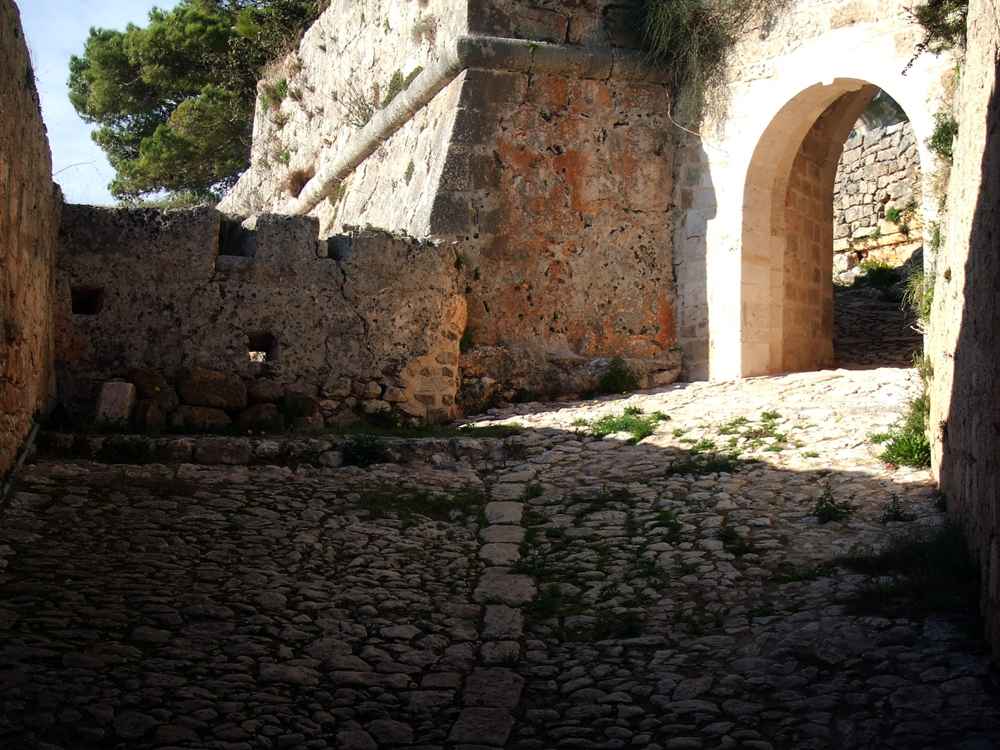
What survives inside the walls of the castle today?
Inside the walls survive the ruins of the medieval town, its cisterns, the Venetian Lion of Saint Mark over a gate, and the remains of churches including the Evangelistria. The earthquake of ruined much of what stood.
The most complete survivor is the circuit of walls itself, which still traces the polygon of the fortress around the crown of the hill. Stretches of curtain wall, bastions and the line of the gates remain, enough to walk the full perimeter and read the plan of the defences. The main gate keeps the carved Lion of Saint Mark above it, the winged lion of Venice, worn but legible after centuries in the open air. This relief is among the most tangible marks of the Venetian centuries, a badge of sovereignty set in stone where every visitor once entered the fortified town on the hill.
Within the enceinte the ground is covered with the low remains of the medieval town. Foundations and fragments of walls mark where houses and streets once stood, laid out in the dense pattern of a settlement pressed inside its defences. Among them lie the cisterns that gathered and stored rainwater for the community, their vaulted or sunken chambers still discernible. These reservoirs were the lifeline of a town without a natural spring on its dry summit, and their survival records the practical genius that made long habitation possible. Weeds and wild plants now grow over the stones, softening the outline of the vanished streets within the walls.
Several churches stood inside the walls, and their ruins remain among the most evocative features of the site. The Evangelistria is named among them, its broken walls marking the piety of the medieval capital. Other ecclesiastical remains lie scattered across the enclosure, fragments of the chapels that served so populous a town. The religious buildings were the focus of communal life, and their ruin conveys the scale of what the site once held. Carved stones, doorways and the odd surviving arch stand among the rubble, the last fabric of a townscape that filled the hilltop in the centuries of the castle’s greatness.
The earthquake of , which struck the Ionian islands with great force, brought down much of what still stood on the hill. Buildings already weakened by the abandonment of two centuries collapsed, and the damage compounded the slow ruin that had followed the move to Argostoli. What remains is therefore a landscape of fragments, walls reduced to their footings, churches open to the sky, houses marked only by their outlines. The circuit of ramparts, more solidly built, weathered the shocks better than the domestic quarters within, so the defences read more clearly than the town they enclosed. The site stands preserved as a ruin and cared for as a monument.
What is the village of Kastro below the castle like?
The village of Kastro spreads across the slope below the fortress, keeping traditional houses, cafes and tavernas. It shares the hill with the neighbouring settlement of Peratata in the Livatho plain.
Below the ramparts the small village of Kastro clings to the hillside, its houses stepping down the slope beneath the walls. The settlement takes its name directly from the castle above, and its life has long been bound to the fortress on the height. Stone houses in the traditional Ionian manner line narrow lanes, some rebuilt after the earthquake, others older, their gardens and vines climbing the terraces. The pace is that of a quiet rural village, set among the olive groves and fields of the Livatho. From its lanes the walls of the castle rise overhead, a constant presence above the roofs of the houses.
The village keeps a handful of cafes and tavernas, gathered where the road widens and near the approach to the castle. These serve the residents of the Livatho and the visitors who climb to the fortress, offering the cooking of the island in the shade of plane trees and vines. A coffee or a meal in Kastro is part of the visit for many who come to the ruins, a pause in the village before or after the walk up. The tavernas draw on the produce of the surrounding plain, and the setting, beneath the medieval walls, lends the ordinary business of eating a long backdrop of history.
Peratata, the larger neighbouring village, lies on the northern side of the hill and shares the approach to the castle. Together the two settlements form the inhabited base of the fortress, strung along the road that climbs from the plain. The area is thoroughly rural, its economy resting on farming, olive oil, the vine and, in season, the visitors drawn to the monument. Distances here are short, the villages sitting within kilometres of one another and of Argostoli, and the whole Livatho is easily crossed by road. The castle hill is the landmark that orders the landscape around these communities of the plain.
The rhythm of the villages changes with the season. Through the warmer months the tavernas fill and the path to the castle sees a steady stream of walkers, while the cooler part of the year returns Kastro to its quiet agricultural round. The Robola vines of the nearby Omala valley are worked through the year, and the olive harvest occupies the plain in its own season. Festivals and church feasts mark the calendar of the villages, tied to the chapels of the district and the memory of the old capital above. The settlement below the walls thus carries on the human life of the hill, long after the fortress emptied.
What views open from the ramparts of the castle?
The ramparts give wide views over the Livatho plain, Argostoli and the airport below. On a clear day the outlook reaches south across the sea toward the island of Zakynthos.
From the walls the whole Livatho plain lies spread below, a patchwork of olive groves, vineyards and villages reaching to the sea. The height of about 300 metres lifts the eye above the intervening ground and opens a panorama in every direction from the circuit of ramparts. Argostoli is visible to the northwest, set around its sheltered gulf roughly 7 km away, the modern capital seen from the seat of the old one. The airport occupies the coastal flat to the south, and aircraft climbing or descending pass in view of the walls. The command of the surrounding country that made the hill a fortress is plain at a glance.
The southward prospect carries across the sea toward Zakynthos, the neighbouring Ionian island, which stands out on the horizon on a clear day. This long view over the water underlines the strategic reach of the site, which watched the sea lanes as well as the land. Closer at hand the eye follows the road network of the Livatho, the scattered churches and the green of the cultivated plain. The sweep takes in the low hills that ring the basin and the line of the coast where plain meets sea. Few points on this part of Kefalonia gather so much of the island into a single outlook.
The quality of the view changes with the light and the weather. Morning throws the plain into clear relief, while the late part of the day lowers the sun over the western sea beyond Argostoli. Casting the ramparts and the villages below into long shadow. Clear air after rain sharpens the far horizon and brings Zakynthos into focus, whereas summer haze softens the distance. The elevated circuit of walls offers the outlook from angles, so a walk around the perimeter turns the panorama steadily from plain to sea to hills. The setting rewards a slow circuit of the ramparts as much as the ruins within them.
The panorama also explains the history written into the stones. From this vantage the garrisons of Byzantium and Venice watched for danger by land and sea, and the rulers of the island surveyed the country they governed. The move of the capital to Argostoli is legible in the view, the harbour town gathered around water that offered what the hill not. Standing on the walls, a visitor reads the logic of the site directly, the fortress placed to see and to hold. The plain that fed its town, the sea that both threatened and sustained the island. The outlook is the clearest surviving witness to why the castle mattered.
How does one visit the Castle of Saint George and what lies nearby?
Visitors reach the castle by the road from Peratata to a car park near the walls, then climb a short path to the gate. The Agios Andreas monastery at Milapidia and the Robola vineyards of Omala lie close by.
The approach to the castle runs by road from the villages of the Livatho. A route climbs from Peratata and the Argostoli direction to a car park set near the foot of the walls, roughly 7 km from the modern capital. From the parking area a paved path rises to the main gate beneath the Lion of Saint Mark, a walk of minutes up a moderate slope. The site occupies open ground, and the visit takes the form of a circuit of the ramparts and a wander among the ruins within. Firm footwear helps on the uneven stone, and the exposed hilltop calls for sun protection in the warmer months.
The warmer half of the year is the usual season for visiting, when the days are long and the paths dry. The exposed summit takes the full sun through the middle of the day. The morning and the later afternoon make the more comfortable hours for the climb and the circuit. The cooler months bring the green of the plain and quieter paths, though rain leaves the stone slippery underfoot. A visit of an hour or two suits the site, enough to walk the walls. Take in the churches and cisterns. Absorb the views before descending to the village of Kastro for refreshment.
The village of Kastro directly below furnishes the natural pause, its cafes and tavernas set within minutes of the car park. A short distance away the Agios Andreas monastery at Milapidia holds Byzantine icons and religious treasures, a fitting complement to the medieval history of the fortress. The two sites, castle and monastery, sit close within the Livatho and combine readily in a single outing. The whole district repays unhurried exploration, its lanes linking villages, churches and the farmland that fed the old capital. The compact scale of this corner of Kefalonia places points of interest within a brief drive of one another.
The Robola vineyards of the Omala valley extend a little inland from the castle hill, where the white Robola grape of Kefalonia is grown on the stony ground. A visit to the vineyards pairs naturally with the fortress, adding the produce of the island to its history. Argostoli itself, the modern capital about 7 km off, offers its waterfront, museums and shops, and the airport lies on the coastal plain to the south. The beaches of the Livatho coast are within easy reach as well. The castle thus sits at the centre of a cluster of destinations, from monastery and vineyard to town and shore, gathered in the south of the island.


Frequently Asked Questions
Where is the Castle of Saint George in Kefalonia?
The Castle of Saint George stands on a hill of roughly 300 metres above the village of Peratata, in the Livatho plain in the south of Kefalonia. It lies about 7 km southeast of Argostoli, the modern capital and largest town of the island. The fortress crowns a low mountain that rises from the fertile Livatho, the richest farmland on Kefalonia, and looks out over fields, villages and the sea. The small village of Kastro spreads on the slope directly below the walls, sharing the hill with Peratata. A road climbs from the plain to a car park near the ramparts, from where a short path leads up to the gate.
The airport lies on the coastal flat to the south, so the castle sits within a short drive of the main points of the district.
Who built the Castle of Saint George?
The Castle of Saint George has two main builders across its long history. The first walls are Byzantine, raised on the hill during the Middle Ages as part of the defensive network of the Ionian islands. The fortress owes its present form to the Venetians, who took the hill and rebuilt it around the year 1500. They gave it the polygonal plan with angular bastions and gates seen today, and set the carved Lion of Saint Mark, the emblem of Venice, above the main entrance. The Republic of Venice held Kefalonia and its castle for the following centuries, keeping the defences current through the age of gunpowder.
The result is a fortress with a Byzantine core enclosed within a Venetian superstructure, the two periods legible together in the surviving walls and gates.
When did the capital of Kefalonia move from the castle to Argostoli?
The capital of Kefalonia moved from the Castle of Saint George down to Argostoli in 1757. For centuries before that the fortified town inside the castle walls had served as the island’s capital, home to several thousand people behind its ramparts on the hill. As the danger of seaborne raids receded and trade gathered around the harbour, the coastal town of Argostoli grew more convenient than the cramped and waterless summit. In 1757 the seat of government, the courts and much of the population shifted to the port, and the old capital on the hill began a long decline. Argostoli has held the role of capital ever since, about 7 km from the fortress it replaced.
The castle passed from a living town into the ruined monument that survives today.
What can be seen inside the castle walls?
Inside the walls survive the ruins of the medieval town that was once the capital of Kefalonia. The circuit of curtain walls, bastions and gates still traces the polygon of the fortress, and the main gate keeps the carved Venetian Lion of Saint Mark above it. Within the enclosure lie the foundations of houses and streets, the cisterns that stored rainwater for the community, and the remains of churches, the Evangelistria among them. The earthquake of brought down much of what still stood, so the interior reads as a landscape of low walls, roofless chapels and scattered carved stone. The more solidly built ramparts survived better than the houses, so the defences are clearer than the town.
A walk of the perimeter takes in both the ruins and the wide views.
What is there to do in the village of Kastro below the castle?
The village of Kastro, on the slope directly below the fortress, keeps traditional Ionian houses, cafes and tavernas along its narrow lanes. Its tavernas serve the cooking of the island, drawing on the produce of the Livatho plain, and make a natural stop before or after the climb to the ruins. The village shares the hill with the neighbouring settlement of Peratata, and the two form the inhabited base of the castle. A coffee or a meal beneath the medieval walls is part of the visit for many who come to the site. The surrounding district rewards exploration on foot or by car, its lanes linking chapels, olive groves and vineyards.
The pace is that of a quiet rural village, ordered by the great landmark of the castle overhead.
What is there to visit near the Castle of Saint George?
Several places of interest lie close to the Castle of Saint George in the south of Kefalonia. The Agios Andreas monastery at Milapidia stands a short distance away and holds Byzantine icons and religious treasures, complementing the medieval history of the fortress. The Robola vineyards of the Omala valley extend a little inland, where the white Robola grape of Kefalonia is grown on stony ground and can be visited alongside the castle. Argostoli, the modern capital about 7 km off, offers its waterfront, museums and shops, while the airport lies on the coastal plain to the south. The beaches of the Livatho coast are within easy reach as well.
The compact scale of this part of the island gathers monastery, vineyard, town and shore within a brief drive of the castle.