
Athens Hiking
Athens hiking is walking on the mountains and hills in and around the Greek capital, on guided tours or on self-guided trails. The city sits in a basin ringed by Hymettus, Parnitha and Penteli, and hills such as Lycabettus and Filopappou rise inside it. Greece Tours lists the guided walks on sale and the routes worth knowing before a first Athens hiking day.
Eight guided Athens hiking tours run on these slopes, from a sunrise climb to a forest walk on secret trails. The pine paths of Mount Hymettus and Kaisariani, the urban trek to the summit of Lycabettus and the Pikionis paths on Filopappou Hill form the core routes. Parnitha and Penteli add longer self-guided walks beyond the city edge.
What is Athens hiking?
Athens hiking is guided or self-guided walking on the mountains and hills in and around Athens, including Hymettus, Parnitha, Penteli, Lycabettus and the Acropolis hills. The city sits in a basin ringed by mountains, so trails start within reach of the centre.
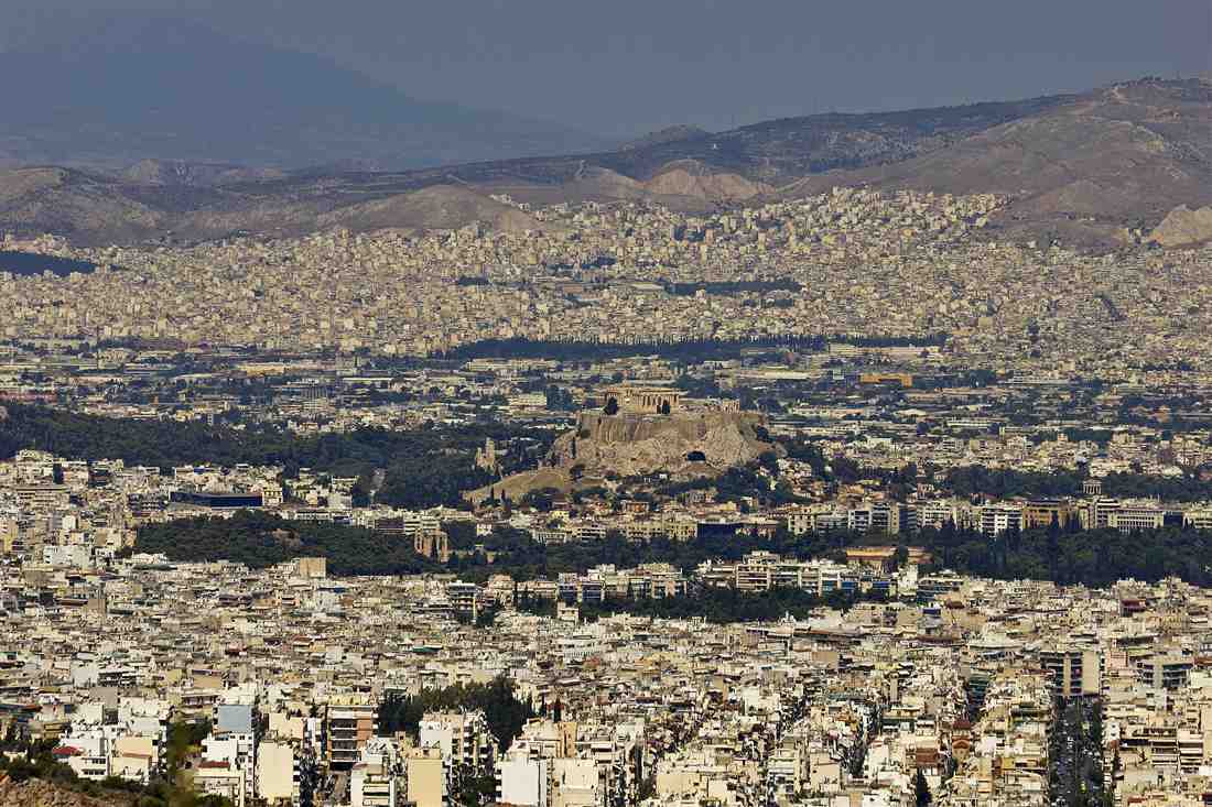
The Athens basin is enclosed by four mountains: Parnitha to the north, Penteli to the north-east, Hymettus to the east and Aigaleo to the west. The Saronic Gulf closes the basin to the south. Inside it, a chain of low rocky hills rises between the buildings, among them Lycabettus, the Acropolis, Filopappou, the Pnyx and the Areopagus. This layout gives Athens hiking two distinct forms: short urban climbs that start from the city streets, and full mountain walks on forest trails that climb above 1,000 metres.
The guided side of Athens hiking covers eight tours on sale, from city-hill climbs at dawn and dusk to mountain hikes on Hymettus. The self-guided side covers the marked trails of Parnitha National Park, the quarry tracks of Penteli and the paved paths of the Acropolis hills, all open to walkers without a guide. Both sides share the same rewards: pine forest, wild herbs such as thyme and sage, ancient sites and wide views over Athens to the sea.
Which Athens hiking tours are on sale?
Eight Athens hiking tours are on sale: a sunrise hike, a hills climb, two Mount Hymettus hikes, a sunset hike, an urban trek to Lycabettus, a Philopappou Hill sunset hike and a forest hiking adventure on secret trails.
The titles split the eight tours into two groups. Five are named for the time of day or for a city landmark: sunrise, sunset, the hills, Lycabettus and Philopappou Hill. Three are named for the mountain and the forest: two on Hymettus and one on secret forest trails. Route, duration, group size and meeting point differ from tour to tour, and the titles fix none of these details, so check the tour listing before booking any Athens hiking tour. The five city and viewpoint tours are these:
- Athens: Ultimate Sunrise Hike – a guided hike timed to the sunrise over the city.
- Athens: Ultimate Hills Climb – a guided hike up two of the city’s hills.
- Athens: Sunset Hike – a guided hike timed to the sunset over the city.
- Athens: Urban Trek from Syntagma Square to Lycabettus Summit – a guided walk from the central square to the top of Lycabettus.
- Athens: Philopappou Hill Sunset Hike – a guided evening walk on the hill facing the Acropolis.
The mountain and forest side of Athens hiking covers rougher ground than the city walks. The two Hymettus tours share the pine and thyme slopes on the eastern edge of the city, and each adds a different goal: one explores a cave, the other visits the Dragon House, an ancient stone building. The forest adventure follows lesser-known trails through woodland, and its listing names the exact area and meeting point. The three mountain and forest tours are these:
- Athens: Mount Hymettus Hiking Tour and Cave Exploration – a guided mountain hike on Hymettus with a cave visit.
- Athens: Mount Hymettus Hike with Dragon House Visit – a guided mountain hike on Hymettus to the ancient Drakospito.
- Athens: Forest Hiking Adventure, Discover Secret Trails – a guided forest hike on lesser-known trails.
What are the Mount Hymettus hiking trails like?
Mount Hymettus hiking trails climb through pine forest and thyme slopes toward the 1,026-metre ridge on the eastern edge of Athens. Two Athens hiking tours run here: one with cave exploration and one with a visit to the Dragon House, an ancient megalithic stone building.
Hymettus, called Ymittos in modern Greek, is a long limestone ridge that runs north to south along the eastern side of the Athens basin. Its lower slopes carry pine forest, and the upper slopes open into low scrub of thyme, sage and other wild herbs. Bees feeding on that thyme produce Hymettus honey, praised by ancient writers and still gathered by beekeepers on the mountain. Athens hiking on Hymettus means dirt tracks and stony paths, with views west over the whole city to the Saronic Gulf and the islands beyond.
The Athens: Mount Hymettus Hiking Tour and Cave Exploration combines a mountain walk with a cave visit, as its title states. The Athens: Mount Hymettus Hike with Dragon House Visit leads to the Drakospito, the Greek name for the Dragon House. Dragon houses are ancient megalithic buildings of huge, roughly cut stone blocks fitted without mortar, best known from southern Euboea, and the Hymettus example stands within reach of the city. For the route, duration and meeting point of either Athens hiking tour, check the tour listing.
Hymettus trails are rocky and exposed above the pine zone, so shoes with grip and a hat matter more here than on the city hills. The upper mountain is dry, and walkers carry all their water from the start. Wind blows hard along the ridge on clear days, so a light jacket earns its place in the pack even in spring. The Mount Hymettus page covers the mountain as a whole, and the forest paths at its foot above Kaisariani form a separate, shadier Athens hiking area.
- Height – 1,026 metres at the highest point of the ridge.
- Terrain – dirt tracks, stony paths and open limestone slopes.
- Plants – pine forest low down, thyme and sage scrub higher up.
- Tours – one hike with cave exploration, one with the Dragon House visit.
What do the Kaisariani forest trails offer?
The Kaisariani forest trails offer shaded pine paths, natural springs and the 11th-century Kaisariani Monastery at the foot of Hymettus. They give Athens hiking a green start on the eastern edge of the city, close to the centre.
Kaisariani Monastery stands on the western slope of Hymettus, in a wooded valley above the suburb of Kaisariani. The main church dates from the 11th century and keeps its Byzantine cross-in-square plan with a dome, with later frescoes covering the interior walls. Around the monastery, pine and cypress forest covers the slope and is protected as a green lung for the city. The Kaisariani Monastery is a common starting point for Athens hiking on the lower slopes of the mountain.
Water is the old reason people came here. Springs rise on the slope near the monastery, and in antiquity the area was known for water believed to have healing powers; a marble ram’s-head spout still pours spring water by the monastery walls. The springs and the tree cover make Kaisariani a cool Athens hiking area on a warm day. Paths lead up from the monastery through the forest toward the higher ridge of Hymettus and join the wider trail network of the mountain.
Forest walks of this kind match the Athens: Forest Hiking Adventure, Discover Secret Trails tour, which follows lesser-known paths through woodland. Its listing names the exact forest and meeting point, so check the tour listing before planning the day around Kaisariani. Self-guided walkers find forest tracks leading up from the monastery grounds, and the gentle gradient of the lower forest suits families and walkers new to Athens hiking.
How does the urban trek from Syntagma to Lycabettus work?
The Athens: Urban Trek from Syntagma Square to Lycabettus Summit starts in the central square and ends on top of Lycabettus, 277 metres high and the highest point of central Athens. The Agios Georgios chapel crowns the summit, and a funicular runs as an alternative.
Syntagma Square faces the Greek Parliament, and Lycabettus rises north-east of it above the Kolonaki district. The streets of Kolonaki climb steadily between the two until the pavement gives way to paths through pine trees on the lower slopes of the hill. This makes the trek an urban form of Athens hiking: city streets first, then a dirt and stone path to the top. For the exact route, pace and duration of this Athens hiking tour, check the tour listing.
Lycabettus is a limestone hill and the highest point in central Athens. The white chapel of Agios Georgios stands on the summit, and the terrace beside it looks over the Acropolis, the city blocks and the sea at Piraeus. The upper part of this Athens hiking route uses switchbacks and steps through pine, agave and prickly pear. The Lycabettus Hill page covers the summit, the open-air theatre on the slope and the view in more detail.
What are the Acropolis hills hikes, from Filopappou to the Pnyx?
Athens hiking around the Acropolis crosses Filopappou Hill, the Pnyx and the Areopagus, the rocky hills on the western side of the Acropolis. Stone paths laid out by the architect Dimitris Pikionis in the mid-20th century link the area, and the Philopappou Hill sunset hike runs here.
Filopappou Hill, also called the Hill of the Muses, rises south-west of the Acropolis. On its summit stands the Philopappos Monument, the marble tomb of Gaius Julius Antiochus Philopappos, a Roman consul and prince of Commagene who lived in Athens in the 2nd century AD. The summit gives a level view straight across to the Parthenon. Filopappos Hill carries pine woods and open rock, and it is the main stage for Athens hiking around the Acropolis.
North of Filopappou lies the Pnyx, the hill where the citizens of ancient Athens met in assembly; the stone speaker’s platform, the bema, is still cut into the rock. Closer to the Acropolis, the Areopagus is a bare rock hill where the ancient council and court sat, and where the apostle Paul spoke to the Athenians. Linking the three hills gives a short Athens hiking loop through the civic history of the ancient city. The Athens: Philopappou Hill Sunset Hike uses this setting at the end of the day; check the tour listing for its start point and timing.
- Filopappou Hill – the Hill of the Muses, with the Philopappos Monument on its summit.
- Pikionis paths – mid-20th-century walkways of stone slabs and reused marble fragments around the Acropolis and up the hill.
- Pnyx – the assembly hill of ancient Athens, with its rock-cut speaker’s platform.
- Areopagus – the rock of the ancient council and court, close to the Acropolis entrance.
When do sunrise and sunset Athens hiking tours run?
Sunrise and sunset Athens hiking tours run around the first and last light of the day, when the sun is low, the air is cooler and the Acropolis glows. Start times follow the season, so check the tour listing for the date booked.
Three Athens hiking tours are built around the edges of the day or around the hills themselves. The Athens: Ultimate Sunrise Hike is timed to the sunrise, the Athens: Sunset Hike is timed to the sunset, and the Athens: Ultimate Hills Climb takes walkers up two of the city’s hills. The Philopappou Hill sunset hike adds a fourth low-light option on the Acropolis hills. Meeting times move with the season: sunrise starts come earlier in summer and later in winter, and sunset starts do the reverse.
From the hills of central Athens the sun rises in the east over Hymettus and sets in the west over the Saronic Gulf and the hills toward Piraeus. At sunrise the Acropolis catches the first direct light, and the streets below are quiet. At sunset the marble turns warm and the lights of the city come on below the hills. The Athens sunset spots page lists the viewpoints that face the evening light.
What hiking is there on Mount Parnitha?
Mount Parnitha, 1,413 metres high and north of the city, is the highest mountain near Athens and a national park with fir forest and red deer. None of the eight Athens hiking tours on sale goes there, so Parnitha is ground for self-guided hikers.
Parnitha closes the Athens basin on the north side and offers the wildest Athens hiking ground near the city. It was declared a national park in 1961, and its upper slopes carry forests of Greek fir, a tree native to the mountains of southern Greece. Red deer live in the park, and the fir woods and gorges shelter birds of prey. The former royal estate of Tatoi lies on its south-eastern foothills, at the edge of the northern suburbs.
The mountain holds a network of marked trails, forest roads and mountain refuges, with the Bafi refuge among the best known. Athens hiking on Parnitha is a full-day outing: longer climbs, colder air than the city and snow on the summit area in winter. The trails pass fir forest, springs and rocky gorges, and the higher points look south over the whole basin to the sea. The Mount Parnitha page covers the national park in more detail.
What about Mount Penteli and the marble quarries?
Mount Penteli rises to 1,109 metres north-east of Athens and supplied the Pentelic marble used for the Parthenon. Ancient quarry paths cross its slopes, and Athens hiking here is self-guided only, since none of the eight tours on sale visit the mountain.
Penteli stands between Parnitha and Hymettus on the north-eastern side of the basin. Its fine-grained white marble, with a faint golden tone from traces of iron, was quarried in the 5th century BC for the Parthenon and the other buildings of the Acropolis. Workers cut the blocks high on the mountain, lowered them on sledges down paved ramps and hauled them by ox cart to the city. Parts of those ancient ramps and cuttings survive, and Athens hiking routes on the mountain pass beside them.
Athens hiking on Penteli follows forest tracks and old quarry roads through pine and past cut marble faces. The Davelis Cave, a large cavern inside an ancient quarry, is the best-known stop, with small Byzantine chapels built into its entrance. Modern quarrying has cut into parts of the mountain, and fires have thinned the forest in places, so the walk mixes open rock with pine woods. The upper slopes look west over the basin and east toward Marathon and the sea.
What coastal hikes are there near Athens, from Sounion to Vouliagmeni?
Coastal Athens hiking runs along the Athens Riviera, from the rocky headland of Cape Sounion and its Temple of Poseidon to the limestone shore around Lake Vouliagmeni. These routes are self-guided walks with sea views, pine woods and swimming coves along the way.
Cape Sounion sits at the southern tip of Attica, about 70 kilometres from the city centre, and the Temple of Poseidon stands on a cliff above the Aegean. Paths leave the temple area and run down to small beaches and along the headland, with views to the island of Makronisos and, on clear days, to Kea. The Sounion National Park behind the cape protects pine forest and the old mining country of Lavrio. The routes are set out on our page on the best hiking trails at Cape Sounion, and Athens hiking on this stretch fits into a day trip that ends at the temple itself.
Closer to the city, the coast between Varkiza and Vouliagmeni offers shorter walks over limestone rocks and low headlands covered in pine. Lake Vouliagmeni lies under a sheer rock face a short walk from the sea, and its brackish water, fed by underground springs, stays warm through the year. Our page on Lake Vouliagmeni covers the lake itself. A coastal walk here ends with a swim, which makes this Athens hiking option popular in the warmer months, when the inland mountains are hot and dry.
The guided Athens hiking tours on sale focus on the hills and mountains around the city, so check the tour listing for any coastal option. The ground here is sharp limestone with little shade, so shoes with grip and a sun hat matter more on the coast than on the city hills. Paths near Sounion are unmarked in places, and an offline map keeps walkers on the right line between the temple, the beaches and the park roads.
How hard is Athens hiking, and which hike suits whom?
Athens hiking ranges from easy walks on the city hills, with a short climb on paved paths, to hard mountain days on Parnitha with steep, rocky ground. Families and beginners suit the city hills, while fit hikers suit the long routes on Hymettus and Parnitha.
Difficulty on an Athens hiking trail depends on two numbers: the height gained and the type of ground underfoot. Filopappou Hill rises to 147 metres and its paths are paved stone or packed earth, so the climb from the Acropolis area is gentle. Lycabettus reaches 277 metres, with a steeper path and steps near the top. Hymettus climbs to 1,026 metres and Parnitha to 1,413 metres, with loose stones, forest tracks and long ascents on open slopes.
Families with children and first-time hikers fit the city hills, where cafés, drinking water and the metro are close at hand. Walkers with some fitness handle the lower slopes of Hymettus, where forest roads and marked paths start close to the suburbs. The high routes on Parnitha suit fit hikers who are used to uneven ground and a steady climb. For guided Athens hiking tours, the route and its level vary from one listing to the next, so check the tour listing before booking.
- Easy – Filopappou Hill, 147 metres, paved and earth paths for families and beginners.
- Easy to moderate – Lycabettus Hill, 277 metres, a steady climb with steps near the summit.
- Moderate – Hymettus, 1,026 metres, forest roads and rocky paths on the lower slopes.
- Hard – Parnitha, 1,413 metres, long climbs through fir forest and over stony ground.
When is the best season for Athens hiking?
The best season for Athens hiking runs from October to May, when daytime temperatures suit long walks. Spring brings wildflowers to Hymettus and the coast, summer calls for starts at sunrise or in the late afternoon, and winter brings rain and some snow on Parnitha.
Spring, from March to May, is the peak of Athens hiking. The hills turn green after the winter rain, and Hymettus is known for its thyme and its spring orchids in flower. Temperatures stay mild through the middle of the day, and the air is clear enough to see across the Saronic Gulf to Aegina. Autumn, from October to November, brings similar conditions after the first rains, with warm sea water that suits a swim after a coastal walk.
Summer, from June to September, is hot, and the afternoons of July and August are the hottest of the year. Summer Athens hiking works only at sunrise or in the late afternoon, on short routes with some shade. Winter, from December to February, is the rainy season. The city hills stay open to walkers, but rain makes limestone slippery, and snow falls on the upper slopes of Parnitha in some winters, which turns the high trails into a winter route that needs proper boots.
What about summer heat and forest fire closures?
On days of high fire risk, the civil protection authorities close forests such as Hymettus and Parnitha to visitors, so summer Athens hiking starts with the daily fire-risk map. Hikers light no fires, smoke no cigarettes and carry water on every route.
Greece runs its official fire season from May to October. Each day in that period, the General Secretariat for Civil Protection publishes a fire-risk map for the next day, grading each area of the country on a scale from 1 to 5. When an area of Attica reaches category 4 or 5, access to its forests, national parks and wooded areas is banned for the day. Athens hiking plans for the summer months therefore depend on this map, which is published the day before.
The closures cover the places that matter most for summer walks: Hymettus, Parnitha, Penteli and the pine forest of the Sounion National Park. A closure day affects guided Athens hiking tours as well, so check the tour listing and any message from the organiser the evening before. A single spark on dry pine needles starts a fire in minutes, which is why open flames, stoves and cigarettes stay out of the forest for the whole season.
Heat is the second summer risk. Afternoon temperatures in July and August pass 35 degrees Celsius, the pale limestone reflects the sun, and shade is thin on the coastal routes and the upper slopes. A summer Athens hiking day starts at first light, finishes before midday and carries at least 1.5 to 2 litres of water per person. Dizziness, headache and nausea are the first signs of heat exhaustion, and the answer is shade, water and a stop.
What do you wear and bring on an Athens hiking trail?
An Athens hiking trail calls for shoes with grip on limestone, 1.5 to 2 litres of water, a sun hat, sunscreen and a light layer. Sunrise and sunset walks add a headlamp, and every hiker carries a phone with an offline map.
Limestone and marble make up the hills of Attica, and the rock turns smooth and slippery where crowds of walkers have passed, as on the paths around the Acropolis hills. Trail shoes or light hiking boots with a deep tread hold better than city trainers on this rock. On every Athens hiking trail in the mountains, loose stones on the steep sections add a second reason for proper soles and, on long descents, for trekking poles.
Clothing follows the season. In spring and autumn, a T-shirt with a light fleece or windproof layer covers the change in temperature between the bottom and the top of a mountain route. In summer, light long sleeves and a wide-brimmed hat protect against the sun. In winter, Parnitha calls for a warm layer, gloves and a waterproof jacket. For Athens hiking tours, the kit list varies by route, so check the tour listing for anything extra the guide asks walkers to bring.
- Shoes – trail shoes or light boots with grip on smooth limestone.
- Water – 1.5 to 2 litres per person, and more in summer.
- Sun protection – a sun hat, sunscreen and sunglasses.
- Light layer – a fleece or windproof jacket for summits and evenings.
- Headlamp and phone – a headlamp for dark starts and a phone with an offline map.
How do you reach Athens hiking trailheads?
Athens hiking trailheads are reached by metro, city bus, taxi or ride app, and the city hills are a walk from the centre. Some guided tours include a meeting point in the centre, so check the tour listing for the meeting and pickup details.
The city hills need no transport at all. Filopappou and the Hill of the Nymphs start a short walk from the Akropoli and Thiseio metro stations, and Lycabettus rises above the Kolonaki district, a walk from Evangelismos metro station. These are the easiest Athens hiking starts for a visitor staying in Plaka, Monastiraki or Koukaki, and the walks fit into a morning before other sightseeing, with coffee back in the centre afterwards.
For the mountains, public transport reaches the edge of the forest. City buses run to the foot of Hymettus from Kaisariani and the eastern suburbs, and suburban routes serve the lower slopes of Parnitha and Penteli. The coast is served by the tram along the Riviera and by the orange KTEL buses to Sounion, which leave from the Pedion tou Areos area. Taxis and ride apps reach every trailhead and are the quickest option for an early start, before the first buses of the day.
- Metro – Akropoli, Thiseio and Evangelismos stations for the city hills.
- Bus and tram – city buses to Hymettus, the tram along the Riviera and KTEL buses to Sounion.
- Taxi and ride apps – direct transport to the trailhead for early starts and remote paths.
- Tour transport – a meeting point in the centre on some guided routes, set out on the tour listing.
Is a guided Athens hiking tour better than going self-guided?
A guided Athens hiking tour adds route knowledge, history, safety and, on some routes, transport. Self-guided hiking gives freedom over time and pace, but waymarking is patchy, so self-guided walkers carry an offline map and tell someone their route.
A guide knows which paths are open, which springs and chapels lie along the way and where the views of the Acropolis and the Saronic Gulf open up. On Hymettus, a guide points out the monasteries and ancient marble quarries that a walker passes without noticing, and on Parnitha a guide keeps the group on the right track through the fir forest. Guided Athens hiking tours also handle the fire-risk map, the weather and the timing.
Self-guided hiking suits confident walkers who read a map well. Waymarking on Athens hiking trails is patchy: some paths carry paint marks and signposts, while others fade into goat tracks and forest roads with no sign at the junctions. Offline map apps with downloaded trail layers fill the gap. Before leaving, a self-guided walker tells someone the route and the expected return time, since phone signal drops in some valleys.
- Route knowledge – the guide knows the path, and the self-guided walker relies on an offline map.
- History – the guide explains the sites, and the self-guided walker reads up beforehand.
- Safety – the guide checks fire risk and weather, and the self-guided walker checks both alone.
- Transport – some tours include it, and the self-guided walker arranges it.
How do you combine a hike with sightseeing in Athens?
Athens hiking combines with sightseeing because the trails start close to the main sights. A morning on the Acropolis hills leads into a city walking route, the crags around the city hold climbing routes, the mountains carry ATV tracks, and coastal hikes end with a swim.
The Acropolis hills fit into a sightseeing day without a change of shoes. A walk over Filopappou and past the Areopagus leads down to the Ancient Agora, Plaka and Monastiraki, which form the core of the Athens walking tour route through the historic centre. Starting the hike at first light and joining the city route afterwards keeps the climb out of the midday heat and puts the museum visits in the hottest hours, indoors.
Active visitors add a second sport to the same trip. The limestone crags around the city, such as Varkiza on the coast, are the base for rock climbing in Athens, and guided sessions take beginners onto the rock. For motorised time in the hills, an ATV tour near Athens covers dirt tracks that walkers reach only on long Athens hiking days, and the route is set out on the tour listing.
Coastal hikes end at the water. A walk on the Sounion headland finishes on a beach below the temple, and the rocky paths near Vouliagmeni lead to swimming coves and to the Riviera beaches along the coast road. Planning the day as hike first, swim second and dinner by the sea is the simplest way to fit Athens hiking into a beach day, with the walk done before the sun is at its highest.
Is Athens hiking worth it?
Athens hiking is worth it for the views of the Acropolis and the Saronic Gulf, for real nature within the city limits and for trailheads a metro ride or short drive from the centre. It adds a green, open side to a city break.
Few European capitals have real mountain trails inside the metropolitan area. Hymettus rises on the eastern edge of the city, Parnitha holds a national park with fir forest and wildlife, and the coast from Vouliagmeni to Sounion joins sea cliffs and ancient ruins in one walk. The view back over the city, with the Acropolis in the middle and the Saronic Gulf behind, is a reward that no bus tour gives.
Access is the strongest point. The city hills need no transport, the mountains start at the end of city bus routes, and the Sounion coast is a single bus ride away. A short Athens hiking route fits into a morning, which leaves time for museums, food and the evening in Plaka. For visitors who want to take the habit further, our page on the top hiking trails in Greece covers the island and mountain routes beyond Attica.
Frequently Asked Questions
Can beginners join an Athens hiking tour?
Yes. The city-hill walks on Lycabettus and Filopappou suit beginners with normal walking fitness, since the climbs are short and the paths are paved or well trodden. The Hymettus hikes cover longer, rougher ground, so check the tour listing for the level.
Do Athens hiking tours run in winter?
Athens hiking works year-round on the city hills and Hymettus, since the basin has mild winters. Winter dates depend on each tour, so check the tour listing for the dates on sale. Rain and strong wind are the main winter factors on the trails.
Is there drinking water on Athens hiking trails?
Water points are few. The city hills have kiosks and cafes near their foot, Kaisariani has springs by the monastery, and the upper slopes of Hymettus, Parnitha and Penteli are dry. Carry at least one litre per person, and more in summer.
Which Athens hiking trail faces the Parthenon most directly?
Filopappou Hill faces the Parthenon most directly. Its summit, beside the Philopappos Monument, stands at about the same height as the Acropolis rock and looks straight across at the temple, which makes it the main photo point for Athens hiking on the Acropolis hills.
Can Athens hiking be combined with sightseeing in one day?
Yes. The Acropolis hills sit beside the Acropolis and the Ancient Agora, and Lycabettus rises above Kolonaki, so a sunrise or sunset Athens hiking tour fits around museum and site visits. The Hymettus hikes take a larger share of the day.