
Akrotiri is the peninsula north-east of Chania in western Crete, holding the airport and Souda port, the quiet beaches of Stavros and Seitan Limania, the Agia Triada and Gouverneto monasteries, and the hilltop tomb of Eleftherios Venizelos above the city. Plan the whole trip with Greece Tours.
This guide covers Akrotiri in full: what and where the peninsula is, the tomb of Venizelos, the Agia Triada and Gouverneto monasteries and the Katholiko, the airport and Souda Bay with its war cemetery, the history, the best beaches from Stavros and Seitan Limania to Kalathas and Marathi, whether it suits families, how to get there from Chania, how long you need, and where to stay, a short drive from Chania town.
What is Akrotiri in Crete?
Akrotiri is the broad peninsula that juts north-east of Chania town on the north-west coast of Crete. It holds Chania International Airport, the deep port of Souda, quiet coves, historic monasteries and the hilltop tomb of Eleftherios Venizelos.
The name Akrotiri translates directly as “cape” or “headland”, and the peninsula earns it. The landmass reaches into the Cretan Sea and shelters Souda Bay on its southern flank, creating one of the largest natural harbours in the Mediterranean. On its plateau sit farming hamlets, olive groves and vineyards, while the coastline breaks into secluded beaches such as Kalathas, Stavros and Marathi. This mix of transport hub, working countryside and pilgrimage sites gives Akrotiri a character distinct from the crowded old-town waterfront of nearby Chania.
Visitors treat Akrotiri as both a gateway and a destination. The airport delivers arrivals straight onto the peninsula, and the port of Souda receives the overnight ferries from Piraeus. From those two entry points the plateau spreads out towards three monasteries, the Venizelos Graves, the Commonwealth war cemetery and a string of swimming bays. The whole headland fits inside a half-day drive, and the elevation grants long views back across the Bay of Chania to the White Mountains.
Akrotiri also carries the practical weight of the wider prefecture. Government offices, the University of Crete’s Chania campuses and the Technical University occupy parts of the plateau, so the peninsula functions as a residential and academic extension of the town. That everyday life sits beside the sacred and the historic: a working olive press at one monastery, a fortress-monastery at the edge of a ravine, and a marble tomb where the most consequential Greek statesman of the modern era rests above the sea.
The peninsula rewards travellers who move at a slow pace. A morning covers a monastery and a swim, an afternoon covers the war cemetery and a viewpoint, and an evening returns to the harbour for dinner. The landscape shifts within a few kilometres from cultivated groves to bare limestone to sheltered cove, and the light changes with it, sharp and white at midday, warm and long towards dusk over the Bay of Chania.
Where is the Akrotiri peninsula?
The Akrotiri peninsula lies immediately north-east of Chania on the north-west coast of Crete. Its landmarks sit 10 to 15 kilometres from the old town by road, and the headland forms the northern arm that encloses Souda Bay.
From the centre of Chania the drive onto the plateau climbs east past the Venizelos Graves at Profitis Ilias, a viewpoint reached in about 6 kilometres. Chania International Airport stands near the eastern edge of the peninsula, 14 kilometres from the town by road. The monasteries of Agia Triada and Gouverneto lie towards the northern tip, roughly 15 to 20 kilometres out, along a road that narrows as it approaches the coast and the Katholiko ravine. Details of the routes onto the peninsula appear in the guide on how to get to Chania.
The shape of the headland resembles a blunt triangle pushing into the Cretan Sea. Its western coast faces the open Bay of Chania and carries the swimming beaches of Kalathas, Tersanas and Stavros. Its eastern and southern flanks curve inland to form Souda Bay, the sheltered inlet that hosts the commercial port and the naval base. Between the two coasts a limestone plateau rises to modest heights, treeless in parts, dotted with thyme, carob and olive, and cut by dry ravines that drain towards the sea.
Distances stay short across the peninsula, which keeps every landmark within easy reach of the others. A traveller drives from the airport to Stavros beach in about 20 minutes, from the town to Agia Triada monastery in about 25 minutes, and from the port of Souda up to the Venizelos Graves in a similar span. This compactness lets a single itinerary link a monastery, a beach and a viewpoint before returning to the harbour for the evening.
A single road spine ties the peninsula together. The main route climbs from Chania past the Venizelos Graves, branches towards the airport and the eastern coast, and runs north through farming villages to the monasteries at the tip. Side roads peel off to Kalathas, Tersanas and Stavros on the western shore. The absence of a coastal ring road keeps the northern coves quiet, and the plateau villages of Kounoupidiana, Chorafakia and Sternes mark the junctions along the way.
What is the tomb of Eleftherios Venizelos on Akrotiri?
The tomb of Eleftherios Venizelos stands on the Profitis Ilias hill at the western edge of Akrotiri, 6 kilometres from Chania. The Venizelos Graves hold the statesman and his son Sofoklis beneath simple marble slabs, beside a small chapel and a commanding statue.
Eleftherios Venizelos, seven times Prime Minister of Greece and the architect of the modern Greek state, chose this hill for his burial. The site overlooks the town he came from and the sea he watched as a boy. Two flat marble tombs mark the graves of father and son, kept plain by design, without ornate mausoleum walls. A statue of a rebel raising a rifle rises nearby, a monument to the Cretan revolutionaries who defied Ottoman and Great Power rule on this exact hill.
The location fixes a defining moment of the Cretan struggle. On Profitis Ilias in the late nineteenth century, insurgents raised the Greek flag against the wishes of the occupying Great Powers. A shell from an allied warship struck the flagpole, and a rebel held the flag aloft with his own body, an act of defiance recorded in the monument’s stance. That episode turned the hill into sacred ground for the independence movement long before Venizelos was laid to rest here.
The Venizelos Graves double as the finest free viewpoint on the peninsula. From the terrace the whole Bay of Chania opens out: the Venetian harbour, the lighthouse, the sprawl of the modern town and, beyond, the snow-streaked ridge of the White Mountains. Caf\u00e9s cluster at the car park, and the terrace fills at sunset as the light turns the bay copper. Entry to the graves and the terrace costs nothing, and the walk from the parking area to the tombs takes minutes.
Beside the tombs stands the small church of Profitis Ilias, which gives the hill its name and predates the graves. The chapel keeps its doors open to pilgrims, and a memorial garden of pines and oleander surrounds the site. The proximity to town makes the graves a natural first or last stop on any Akrotiri route, reached in a short drive from the Venetian harbour and paired easily with the monasteries further north or a swim on the western coast.
What is the Agia Triada monastery (Tsangarolon)?
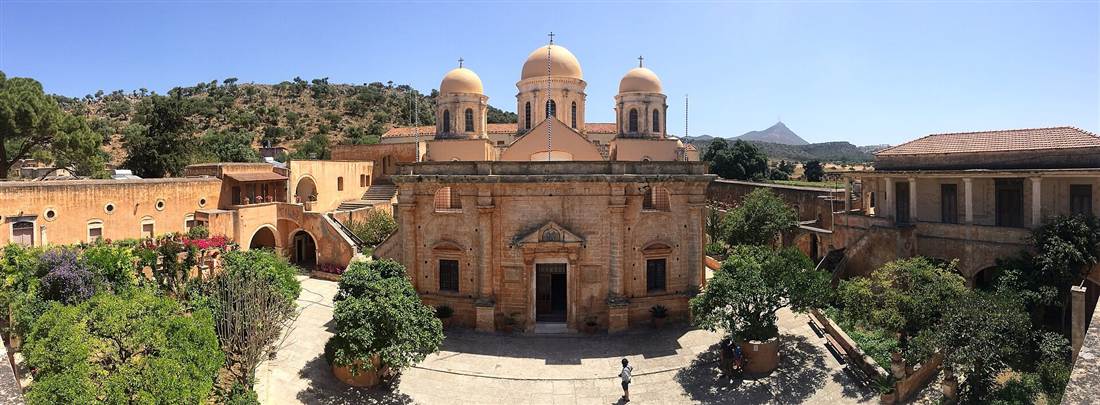
Agia Triada, also named Tsangarolon after the founding brothers, is a Venetian-Renaissance monastery on the Akrotiri plateau, about 15 kilometres from Chania. Its honey-coloured stone fa\u00e7ade, walled courtyard, working olive press and vineyard make it the most visited monastery on the peninsula.
Two brothers of the Venetian-Cretan Tsangarolo family founded the monastery, and their surname stuck as its second name. The architecture fuses Orthodox monastic tradition with the Renaissance idiom of the Venetian rulers of Crete: a symmetrical stone frontage, a triple-arched gateway inscribed in Greek, and Doric and Corinthian detailing on the central church. The domed katholikon dedicated to the Holy Trinity stands at the heart of a spacious courtyard lined with cypresses and palms, framed by the bare hills of the plateau behind.
Agia Triada functions as a producing estate as well as a place of worship. The monks press olives from the surrounding groves into extra-virgin olive oil, bottle their own wine from the vineyard on the slopes, and produce honey and vinegar. A shop inside the walls sells these goods to visitors, and the income sustains the community and the restoration of the buildings. The old olive press, the cellar and the museum of icons and manuscripts open to the public alongside the church.
The monastery keeps an active religious calendar and a modest entry fee that funds its upkeep. A small ecclesiastical museum inside displays post-Byzantine icons, illuminated manuscripts, vestments and liturgical silver rescued through centuries of upheaval. The tranquil courtyard, the scent of the groves and the golden stone draw a steady flow of visitors, and the site sits on the direct road to the Gouverneto monastery deeper into the peninsula, linking the two in one excursion.
A dress code applies to visitors, in keeping with the monastery’s active status: covered shoulders and knees at the church. The bottled olive oil, the wine and the honey sold at the gate carry the estate’s own label, and the produce ranks among the practical souvenirs of a visit to Akrotiri. The setting, ringed by hills and open to the sky, turns a short stop into a full encounter with the Venetian-Cretan heritage of the peninsula.
What is the Gouverneto monastery and the Katholiko?
Gouverneto is a fortified monastery near the northern tip of Akrotiri, about 19 kilometres from Chania. A walking trail below it descends past the cave-church of the Bear to the abandoned Katholiko, the oldest monastery on Crete, set in a dramatic ravine that opens to the sea.
The Gouverneto monastery, dedicated to Our Lady of the Angels, presents a compact square fortress with corner bastions and a single defended gateway, a design forced by centuries of pirate raids on this exposed coast. Inside, the stone church carries carved Venetian ornament on its fa\u00e7ade. The building sits at the end of the paved road, and from its gate a stone path drops north towards the coast and the older sacred sites hidden in the gorge below.
Partway down the trail the path reaches the Arkoudiotissa, the Cave of the Bear. A large stalagmite inside the cavern resembles a crouching bear, and legend records that the Virgin turned a bear to stone here to protect the monks’ water. A small chapel stands at the cave mouth. The descent continues over rough steps, exposed to the sun and demanding sturdy footwear, towards the ravine floor where the earliest monastic settlement waits.
At the bottom lies the Katholiko, the monastery of Saint John the Hermit, carved into and built against the cliff of a deep ravine. Monks abandoned it centuries ago after relentless pirate attacks, retreating uphill to the fortified Gouverneto. A great stone bridge spans the gorge beside the ruined cells and the cave-church, and the dry riverbed runs on to a rocky inlet where the ravine meets the sea. The full walk down and back up takes about two hours and rewards the effort with one of the wildest landscapes on the peninsula.
The trail demands preparation. It carries no shade, the stone steps grow uneven towards the ravine floor, and water and firm footwear count as essentials for the climb back up. Gouverneto keeps its own visiting hours and dress code, and the gate to the trail sits within its grounds. The reward is a chain of sacred sites strung down a single gorge: the fortress at the top, the bear cave in the middle, and the ancient Katholiko at the bottom, spanning the whole arc of Cretan monastic history in one descent.
What is at Chania International Airport on Akrotiri?
Chania International Airport “Ioannis Daskalogiannis” occupies the eastern side of the Akrotiri peninsula, 14 kilometres by road from Chania town. It is the principal air gateway to western Crete, handling domestic flights to Athens and Thessaloniki and direct seasonal routes across Europe.
The airport bears the name of Ioannis Daskalogiannis, the Cretan rebel leader who rose against Ottoman rule. Its single terminal handles arrivals and departures side by side, with car-hire desks, caf\u00e9s, a duty-free area and taxi ranks outside the doors. A single runway serves passenger jets and the adjacent military air base, and the airfield’s plateau position gives arriving passengers a first view over Souda Bay and the White Mountains as the aircraft turns onto final approach.
Its place on Akrotiri makes the peninsula the first ground most visitors to western Crete touch. From the terminal a taxi reaches central Chania in about 20 minutes, and public buses connect the airport with the town’s central bus station and the port of Souda. The road runs west across the plateau, passing turnings to Stavros beach and the monasteries, so a traveller with a hire car reaches a swimming bay or a monastery within minutes of collecting the keys.
Peak-season traffic swells the terminal, and a well-timed transfer removes the friction of arrival. Pre-booked taxis and private transfers wait at the arrivals door, hire cars sit in the adjacent lots, and the bus stop lies steps from the exit. Early planning of that first leg turns the airport from a bottleneck into a quick threshold onto the peninsula and the town beyond.
The airport anchors the peninsula’s role as a hub without dominating its landscape. Beyond the perimeter the plateau returns to olive groves, grazing land and quiet villages, and the flight paths pass over the empty northern coves rather than the resorts. This proximity lets arriving visitors reach Kalathas or Stavros for a first swim, or the Venizelos Graves for a first panorama, before entering the busier town, and it lets departing travellers spend a final morning on the peninsula close to the gate.
What is the history of Akrotiri?
Akrotiri holds a central place in the Cretan struggle for union with Greece. Its Profitis Ilias hill witnessed the defiant flag-raising against the Great Powers, and the peninsula gave the nation Eleftherios Venizelos, the statesman who steered Crete into the modern Greek state.
Long before the modern era the peninsula drew hermits and monks to its ravines, and the Katholiko monastery of Saint John the Hermit dates among the oldest on the island. Venetian rule from the thirteenth century onward left the Renaissance monasteries of Agia Triada and Gouverneto and the fortifications that guarded Souda Bay. Ottoman rule followed, and Akrotiri, with its commanding hills above Chania, turned into a stage for the revolts that punctuated the nineteenth century.
The defining event unfolded on Profitis Ilias during the insurrection of the late nineteenth century. Cretan revolutionaries gathered on the hill and raised the flag of union with Greece in open defiance of the occupying Great Powers, whose fleet lay in Souda Bay. When a naval shell shattered the flagpole, a rebel stepped forward and held the flag upright against his body, an image that fixed the hill in national memory and set the tone for the final push towards independence.
Eleftherios Venizelos, born in Chania and shaped by these events, rose to lead the Cretan movement and then the Greek nation. His choice of the same hill for his grave binds the personal and the political: the statesman who completed the union of Crete with Greece rests where the rebels first raised its flag. In the twentieth century the peninsula’s strategic value returned to the fore when Souda Bay became a battleground and then a NATO naval anchorage, adding a new layer to a long military history.
These strands remain visible on the ground. The monasteries record the Venetian and Byzantine centuries, the graves and the rebel statue record the fight for union, and the war cemetery on Souda Bay records the sacrifice of the Battle of Crete. A visitor who traces the peninsula from the tomb on Profitis Ilias to the harbour at Souda walks through the whole modern history of the island, from monastic refuge to national struggle to twentieth-century war.
What is Souda Bay and the war cemetery on Akrotiri?
Souda Bay is the deep natural harbour along the southern shore of Akrotiri, one of the largest and safest anchorages in the Mediterranean. It holds the commercial port of Chania, a major naval base, and the Souda Bay Commonwealth War Cemetery on its southern edge.
The bay cuts inland for about 15 kilometres and reaches great depth, sheltered by the arm of the Akrotiri peninsula to the north and the mainland ridge to the south. This geography made it a prized harbour across every era, from Venetian galleys to the modern fleet. Today the port of Souda receives the overnight ferries from Piraeus and the cruise ships that call at Chania, while the eastern reaches host the Hellenic Navy and a NATO base, keeping the historic strategic role alive.
On the bay’s quiet southern shore lies the Souda Bay War Cemetery, maintained by the Commonwealth War Graves Commission. Rows of white headstones set in clipped lawns and framed by flowering shrubs mark the graves of Commonwealth servicemen who fell in the Battle of Crete and the wider Mediterranean campaign. The cemetery stands open to all, free of charge, its calm setting between the water and the hills forming a place of reflection above the working harbour.
Souda ties the peninsula to the wider world in a way the monasteries and beaches do not. The ferries dock here, buses run between the port and Chania’s centre in about 15 minutes, and the naval traffic gives the eastern bay a purposeful edge. For the visitor the bay pairs the practical business of arrival and departure with a solemn memorial, and its viewpoints look back across the water to the plateau, the monasteries and the distant peaks that define the Akrotiri skyline.
The war cemetery holds close to 1,500 graves, tended year-round and marked at its entrance by the Cross of Sacrifice. A register at the gate records the names, and the grounds stay quiet even as ferries and cargo ships move across the water beyond the shrubs. The contrast defines Souda: a living port and naval base on one shore, a place of memory on the other, both framed by the sheltering arm of the Akrotiri peninsula.
What are the best beaches on Akrotiri?
The best beaches on Akrotiri are Stavros, Marathi, Kalathas, Loutraki, Tersanas and Seitan Limania. This tight cluster gives the peninsula sheltered family coves, twin sandy bays and one dramatic fjord, all within a 20-minute drive of Chania town.
Akrotiri packs its shoreline into a compact ring of bays on the peninsula’s northern and eastern edges. Kalathas, Tersanas and Loutraki face north toward Chania across Souda Bay’s outer waters, presenting shallow calm coves with fine sand. Stavros sits at the peninsula’s north-west tip beneath a bare limestone mountain, and Marathi lies on the sheltered south-eastern shore inside Souda Bay. Seitan Limania cuts into the wild eastern cliffs as a narrow inlet of vivid turquoise water.
Each beach answers a different mood. Families with toddlers head for the flat sand and gentle depth of Kalathas and Marathi. Swimmers who want stillness pick Stavros, where the round bay blocks the wind. Photographers and confident walkers descend to Seitan Limania for the most theatrical scene in the region. The short distances between them make a beach-hopping day on Akrotiri straightforward, and the whole set feeds into the wider run of sand described on the Chania beaches guide.
Water quality across the peninsula is high, with clear visibility and clean sand at the organised coves. Stavros, Marathi and Kalathas carry sunbed rows, tavernas and parking, while Seitan Limania stays raw with a single kiosk and a rough car park at the clifftop. The contrast between the tame family bays and the wild fjord is the defining feature of Akrotiri swimming.
Loutraki rounds out the set as a small pebble-and-sand cove tucked below Kalathas, reached by a short path and rewarding early arrivals with quiet water and a single taverna. The proximity of every bay to the next turns the peninsula into a natural beach circuit: a driver moves from north-coast sand to inner-bay shelter to eastern fjord in one loop, sampling six distinct swims between breakfast and sunset.
What is Stavros beach on Akrotiri?
Stavros is a round, sheltered bay at the north-west tip of Akrotiri, framed by a bare limestone mountain that starred in the finale of Zorba the Greek. The shallow, calm, almost lagoon-still water makes it a favourite for young children.
The bay forms an near-perfect circle of sand and pebble, enclosed on one side by the great rock face that rises straight from the shore. That mountain is the famous backdrop of the Zorba the Greek dance scene, and walkers still climb its lower slopes for the view down onto the water. The enclosed shape kills the wind and swell, so the sea stays flat and warms early, turning the bay into a natural paddling pool.
Stavros sits about 15 km from Chania town, a 20-minute drive north through the villages of the peninsula. The beach carries two faces: the main circular lagoon with sunbeds, a taverna row and a car park, and a second open stretch of sand beside it that faces the outer sea. The lagoon side suits families and weak swimmers; the open side draws those who want a longer swim and a breeze.
Tavernas line the back of the bay, serving fish, Cretan meze and cold drinks within steps of the sand. The setting stays low-rise and quiet outside the peak weeks, and the dramatic mountain wall gives the beach a scale that the softer coves nearby lack. Stavros ranks as the signature swim of Akrotiri for its film history and its still, child-safe water.
The bay wakes early and stays busy through the middle of the day, so a start before ten secures both a parking space and a front-row spot on the sand. Snorkellers explore the rocks at the lagoon’s edges, where small fish gather in the shallows, and walkers trace the goat paths up the mountain for the aerial view that matches the film’s closing frame. A sunset drink at a taverna caps the day as the rock face turns gold above the still water.
What is Seitan Limania beach?
Seitan Limania is a dramatic narrow fjord cove on the wild eastern side of Akrotiri, where a slot of vivid turquoise water cuts between towering grey cliffs. A steep path drops to the sand, and the descent demands sturdy footwear and care.
The name translates as “devil’s harbours”, and the setting earns it. Three thin inlets slice into the rock, and the central one holds a short beach of pale pebble and sand at the foot of a gorge. The water glows an intense turquoise against the dark stone, deepening fast a few strides from shore. The scene is the most photographed on the peninsula, drawing crowds to the clifftop viewpoint above the car park.
The catch is the access. A rough, steep footpath winds down the cliff from the parking area, loose in places and exposed to the sun, taking 10 to 15 minutes on foot. Walkers need proper shoes with grip, water, and a steady head, since the path has no handrail. The cove itself is small and fills quickly, offering almost no shade, so early arrival is the key to a spot on the sand.
Once down, the reward is a swim in the clearest water in Crete, hemmed by sheer walls that glow at midday. Currents pick up when the wind funnels through the gorge, so swimmers stay close to the cove mouth in rough conditions. Seitan Limania lies about 22 km east of Chania, at the far end of Akrotiri beyond the villages, and stands as the peninsula’s wild counterpoint to the tame northern bays.
The clifftop viewpoint above the cove is a destination in its own right, delivering the postcard shot of the turquoise slot for those who skip the descent. A goat track along the rim leads to further inlets and rock ledges where confident swimmers jump into deep water. The absence of shade, sunbeds and food beyond a seasonal kiosk keeps Seitan Limania a place for prepared visitors who bring water, a hat and firm footwear, and who time the trip for the cooler edges of the day.
What are Kalathas and Tersanas beaches?
Kalathas and Tersanas are shallow, sheltered family coves on the north coast of Akrotiri, both a 10-minute drive from Chania. Kalathas offers a wide arc of soft sand and a tiny islet to swim to; Tersanas is a smaller, quieter horseshoe bay.
Kalathas is the busier of the two, a broad sandy beach with a gentle slope that keeps the water knee-deep well out from the shore. A small rocky islet sits close offshore, a short paddle for stronger swimmers and a landmark for children building sandcastles opposite it. Sunbeds, umbrellas, a beach bar and a car park serve the main stretch, while quieter sand extends to either side for those who bring their own shade.
Tersanas lies just around the headland, reached down a narrow lane through a small settlement. The bay is a compact horseshoe of sand and shingle, ringed by low rock and holiday houses, with water so shallow and clear that the bottom stays visible far out. Its size keeps the crowd small, and the single taverna above the sand supplies lunch and cold drinks without any resort bustle.
Both coves sit roughly 10 to 12 km from Chania, an easy hop north from the town’s edge. Their flat, warm, wind-protected water makes them a first choice for parents of toddlers, and their proximity to town means a morning swim slots neatly around a day of sightseeing. The pair reward visitors who want calm sand without the drive to the peninsula’s far corners.
Kalathas fills with day visitors from Chania through the middle of the day, while Tersanas holds a steadier local crowd of families who return year after year. Pine and tamarisk trees along the back of both bays throw natural shade for those without an umbrella, and the sandy sea floor keeps the water clear even when the beaches are busy. The gentle setting makes the pair the peninsula’s easiest introduction to swimming near Chania.
What is Marathi beach?
Marathi is a pair of twin sandy bays on the sheltered south-eastern shore of Akrotiri, inside Souda Bay. Shallow, warm, wind-protected water and a line of fish tavernas make it a steady family swimming spot 15 km from Chania.
Two small beaches sit side by side, divided by a low rocky spur, each a scoop of golden sand backed by tavernas and parking. The position deep inside Souda Bay shields Marathi from the north wind that ruffles the peninsula’s outer coast, so the sea here stays flat and glassy through the summer. The gentle gradient and clean sand draw local families who want reliable, safe bathing close to town.
The tavernas are the second draw. Tables sit almost on the sand, serving grilled fish, fried calamari and Cretan dishes with the water lapping a few metres away. Sunbeds and umbrellas cover the main bay, and a small harbour with fishing boats adds to the low-key village feel. The setting stays modest and family-led rather than glossy or crowded.
Marathi lies about 15 km from Chania on the south side of Akrotiri, a short drive past the airport turn-off. Its calm, shallow water suits children and older swimmers, and the combination of easy sand and shaded lunch tables makes it a full-day base rather than a quick dip. The bay rounds out the peninsula’s family offering alongside Kalathas and Stavros.
Local families fill Marathi at weekends, and the relaxed rhythm of long taverna lunches and afternoon swims defines the place. The second bay stays quieter than the first, giving space to spread out on the sand away from the sunbed rows. A small church and the fishing harbour anchor the village end, and the flat water reflects the hills of Souda Bay across a sea that stays warm into the shoulder weeks.
Is Akrotiri good for families?
Akrotiri is one of the best family bases near Chania. Its shallow, calm coves at Kalathas, Tersanas, Marathi and Stavros give safe, warm bathing with easy parking, sunbeds and tavernas, all within a 20-minute drive of the town.
The peninsula’s geography does the work for parents. The northern and inner bays face away from the prevailing wind and shelve gently, so the water stays shallow and still far from shore, with no sudden drop-offs at the family coves. Toddlers paddle in ankle-deep sea while older children swim in flat water, and lifeguard-friendly sightlines across the small bays keep everyone in view.
Facilities match the family need. Kalathas, Marathi and Stavros all carry sunbed rows, umbrellas, snack bars and free or cheap parking within steps of the sand, so a day out means no long walk with buggies and beach bags. Tavernas sit at the back of each bay, letting families break for lunch and shade without leaving the beach.
Distance seals the case. From the eastern edge of Chania town the nearest coves are 10 minutes away, so a family staying in the old town reaches soft sand before the heat builds and returns for an afternoon nap. The mix of tame water, short drives and full facilities makes Akrotiri a natural first choice for a Crete holiday with young children, and it pairs with the calmer swimming detailed across the wider Chania coast.
How do you get to Akrotiri from Chania?
Akrotiri lies 10 to 15 km east and north of Chania town, a 15-to-20-minute drive over the Souda Bay road. A hire car gives the freedom to reach every cove and monastery; a local KTEL bus links the town to the main villages.
Driving is the simplest route. From the centre of Chania the road climbs east onto the peninsula, passing the university and the airport turn before branching to the villages and beaches. Kalathas and Tersanas sit 10 to 12 km out, Stavros and Marathi around 15 km, and Seitan Limania about 22 km at the far east. The roads are surfaced and clear, with the last stretch to Seitan Limania steep and winding.
Car hire is booked at Chania airport, which sits on Akrotiri itself, or in the town, and a vehicle unlocks the whole loop of beaches, monasteries and the Venizelos tomb in a single day. Taxis run from town to the main beaches at a fixed rate for those without a car, useful for a direct trip to Stavros or Marathi.
Public buses connect Chania’s central station to Akrotiri’s villages and the airport on a regular timetable, dropping close to Stavros and Kalathas in the season. The bus suits budget travellers heading to one beach for the day, though it leaves the remote fjord of Seitan Limania out of easy reach. For flexible beach-hopping, a car remains the clear choice. Base ideas for the surrounding area sit in the where to stay in Chania guide.
How long do you need on Akrotiri?
A half-day covers one beach and a monastery on Akrotiri; a full day takes in the beaches, the monasteries and the tomb of Venizelos at an unhurried pace. The compact peninsula rewards both a quick swim and a whole day of touring.
For a short visit, pair a morning swim at Stavros or Kalathas with the nearby Agia Triada monastery, and the outing fills three to four hours including the drive from town. This half-day plan works well as a break from the old town, delivering sand, a landmark and a taverna lunch before the afternoon heat peaks.
A full day opens the whole peninsula. A loop by car strings together the Agia Triada and Gouverneto monasteries, the hilltop tomb of Eleftherios Venizelos with its view over Chania, and a long afternoon on the sand at Stavros or Marathi. Adding the descent to Seitan Limania stretches the day, since the cliff path and the small cove demand time and care.
Beach-focused visitors devote a day to hopping between coves, swimming at Kalathas, lunching at Marathi and finishing at Stavros as the light softens. History-minded travellers spend the same day on the monasteries and the Venizelos memorial. Either way, Akrotiri stands as a full day-trip in its own right, close enough to Chania that a return for a second theme stays easy.
Where do you stay on Akrotiri?
Stay in the quiet villages of Kounoupidiana, Stavros, Kalathas and Chorafakia for sea-view apartments, family studios and small hotels. The peninsula suits travellers who want calm, beach-side nights near Chania and the airport rather than old-town bustle.
Kounoupidiana is the largest village, a working settlement with shops, bakeries and tavernas that stays lived-in through the year, making it a practical base with everything to hand. Around it, Kalathas and Chorafakia hold clusters of holiday apartments and villas set among olive groves, most with balconies angled toward the sea and a short walk or drive to the coves.
Stavros offers the most beach-side stays, with studios and small complexes strung behind its famous bay, so a morning swim starts on foot from the room. These properties trade nightlife for stillness, drawing families and couples who want the sound of the sea over the noise of the town. Sea-view apartments here look across the water to the mountain that dances through the film.
Proximity to Chania airport, which sits on the peninsula, makes Akrotiri a smart first or last night before an early flight. The old town of Chania lies 15 minutes away by car for dinners and sightseeing, so a peninsula base blends quiet beach days with easy access to the harbour. Fuller options across the region appear in the guide to Chania.
What is the best way to visit Akrotiri?
The best way to visit Akrotiri is a self-drive loop from Chania that strings together the Agia Triada and Gouverneto monasteries, the hilltop tomb of Eleftherios Venizelos and a long swim at Stavros or Marathi, finishing back in town for dinner.
Start early from Chania and drive east onto the peninsula, taking the monasteries first while the day stays cool. Agia Triada sits in a walled Venetian-Cretan complex among vineyards, and the rougher road beyond leads to Gouverneto and the cave-church trail down toward the sea. These stops give the cultural heart of the day before the beaches.
Turn next to the tomb of Eleftherios Venizelos on the Profitis Ilias hill, where the graves of the Cretan statesman and his son sit under pines with a sweeping view over Chania, the harbour and the White Mountains beyond. The site is free, open to the air and a fitting high point of the loop, both in height and in the panorama it commands.
Close the day at the coast. Drop to Stavros for the round bay under the film mountain, or to Marathi for the sheltered twin sands and a fish-taverna lunch, and let the afternoon run long on the water. Confident walkers add the cliff descent to Seitan Limania for the turquoise fjord. The loop covers under 40 km in total, ties together the peninsula’s landmarks and beaches, and returns to Chania’s old town in time for the evening.
Frequently Asked Questions
What is Akrotiri in Crete?
Akrotiri is the peninsula north-east of Chania in western Crete. It holds Chania International Airport, the port of Souda, the Agia Triada and Gouverneto monasteries, the tomb of Eleftherios Venizelos, and calm beaches at Stavros, Kalathas and Seitan Limania.
What is Stavros beach on Akrotiri?
Stavros is a round, sheltered bay on Akrotiri under a steep mountain, with shallow calm water. It served as the filming location for the dance finale of Zorba the Greek, which draws visitors alongside the family swimming.
How do you get to Akrotiri from Chania?
Akrotiri lies about 10 to 15 kilometres from Chania town, a 15 to 25 minute drive across the peninsula. A hire car reaches the beaches and monasteries best, and local buses run to Stavros, Kalathas and the airport.