
The Samaria Gorge is the headline hike of south-west Crete, cutting roughly 16 km through the White Mountains national park to the Libyan Sea. Walkers begin high on the Omalos plateau at Xyloskalo, around 1,200 metres, then drop down a steep wooden-stepped path into the riverbed below. The route runs one way and downhill, past pine and cypress slopes, the abandoned village of Samaria, and the famous Iron Gates, before reaching the coast at Agia Roumeli. This guide sets out the trail, the terrain, and the practical logistics of the walk, so you can plan the day with confidence and hike it well with My Greece Tours.
The gorge sits within a strictly protected national park, home to the kri-kri, the Cretan wild goat rarely seen elsewhere. The trail is rocky and long, and the only way out from Agia Roumeli is by boat to Sougia or Chora Sfakion, then a bus back over the mountains. For wider context on the island, read our Crete travel guide. The sections below cover the walking route from Xyloskalo to the sea, the Iron Gates, the wildlife of the park, when the gorge opens, and the gear and timing that make the descent safe and rewarding.
What is the Samaria Gorge in Crete?
The Samaria Gorge is a roughly 16 km canyon in the White Mountains of south-west Crete, running from the Omalos plateau down to the coast at Agia Roumeli, and protected as a national park since the 1960s.
The gorge ranks among the longest in Europe, carved by the river that drains the White Mountains, or Lefka Ori, toward the Libyan Sea. It forms the core of a national park set up in the 1960s, covering the valley and the peaks that frame it. The walk starts at Xyloskalo on the southern rim of the Omalos plateau, at about 1,200 metres, and ends at sea level in Agia Roumeli. That drop of more than a kilometre gives the trail its one-way, downhill character.
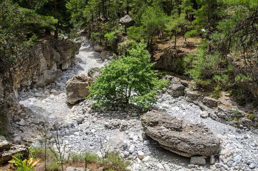
The landscape shifts as you descend, from cypress and Calabrian pine on the upper slopes to sheer limestone walls and a stony riverbed near the exit, where the canyon squeezes to its narrowest point.
The park protects rare plants and the kri-kri, the Cretan wild goat, alongside the ruins of Samaria village, evacuated when the park was created. Hikers pay a park entrance fee at the gate and must exit the same day, since overnight camping inside is not allowed. The trail is well marked and follows the riverbed for much of its length, so route-finding is straightforward, yet the surface is rocky and demands attention with every step. Rangers patrol the gorge and record who enters and leaves.
Rest points with water, benches, and toilets appear at intervals along the way, and the old village of Samaria near the midpoint offers shade and a natural place to pause before the final stretch.
How do you hike from Xyloskalo to Agia Roumeli?
You start at Xyloskalo on the Omalos plateau, descend a steep wooden-stepped path into the valley, follow the riverbed south past Samaria village and the Iron Gates, then continue to the coast at Agia Roumeli.
The first stretch from Xyloskalo drops sharply, using a wooden-railed staircase that switchbacks down the forested slope toward the valley floor. This opening descent covers the steepest ground of the entire route and can be hard on the knees, so take it slowly. The path then eases into the riverbed and runs south, crossing the shallow stream on stepping stones at many points. The old settlement of Samaria sits roughly halfway, marked by stone ruins and a small chapel, and makes a natural rest stop with shade and water. From there the walls close in and the canyon deepens, building toward its dramatic narrows.
The full walk takes most people between four and seven hours, depending on pace and rest.
The final approach passes through the Iron Gates and then opens onto a wide, sun-baked riverbed leading to the sea. Agia Roumeli, the finish, is a small coastal village reachable only on foot or by boat, with tavernas, a pebble beach, and a ferry quay. Many walkers swim before catching the boat that links the village to Sougia or Chora Sfakion, since no road reaches Agia Roumeli directly. Buses then carry hikers back over the mountains to Chania and other towns. Planning the return boat and bus is as important as the walk itself, because missing the last connection can strand you overnight. For nearby coastal bases, see other hidden gems in Crete along this southern shore.
What are the Iron Gates of the Samaria Gorge?
The Iron Gates, or Sideroportes, are the narrowest point of the gorge, where the rock walls rise hundreds of metres on either side yet the passage between them narrows to just a few metres across.
The Iron Gates form the visual climax of the Samaria walk and the image most hikers carry away. At this point the limestone cliffs tower overhead, blocking most of the sky, while the gap at the base pinches down to only a few metres of width. Walkers pass through single file, sometimes on a raised wooden walkway that keeps feet dry above the stream. The scale is genuinely disorienting, with the walls climbing far higher than they are wide. The Greek name, Sideroportes, captures the sense of squeezing between two great gateposts of stone.
This narrows section sits close to the southern end of the gorge, a short distance before the trail widens and heads out toward the coast.
The Iron Gates concentrate the geology of the whole canyon into a single stretch, showing how water has cut down through the mountain over long ages. Photographs rarely convey the height of the walls, so most people simply stop and look up before moving on. The passage stays cool and shaded even at midday, a welcome contrast to the exposed riverbed on either side. Rangers ask hikers not to linger in the narrows during busy periods, keeping the single-file flow moving. Beyond the gates the canyon relaxes, the walls step back, and the light returns as the path runs the last kilometres to Agia Roumeli.
This is the moment that defines the hike among the finest things to do in Crete for active travellers.
What wildlife lives in the Samaria Gorge national park?
The park shelters the kri-kri, the Cretan wild goat, along with birds of prey, endemic plants, and the pine and cypress forest of the upper slopes, all protected within the national park boundary.
The kri-kri is the emblem of the Samaria Gorge and the reason the park earns its strict protection. This wild goat, native to Crete, has curved horns and a pale coat, and clings to the steep, rocky ground where predators struggle to follow. Sightings are never guaranteed, yet patient walkers often spot the animals grazing on ledges above the trail, especially in the quieter early hours. The park exists in part to safeguard the small surviving population, so feeding or approaching them is forbidden. Beyond the goats, griffon vultures and other raptors ride the thermals above the canyon walls, and the forested upper reaches hold songbirds among the pines.
The gorge functions as a refuge where these species can live largely undisturbed by roads or building.
The plant life is as distinctive as the fauna, with species found only on Crete rooted in the cliffs and riverbanks. Calabrian pine and cypress cover the higher slopes near Xyloskalo, giving way to oleander, herbs, and hardy shrubs along the stream lower down. Spring brings wildflowers to the valley floor before the summer heat scorches it brown. The national park rules prohibit picking plants, lighting fires, or leaving the marked path, all of which keep this fragile system intact. Rangers enforce these limits and remove litter that walkers leave behind.
The combination of endemic flora, the kri-kri, and the dramatic terrain is exactly what earned the gorge its protected status and its place on the list of Europe’s most important natural reserves worth guarding for the long term.
When is the best time to hike Crete’s Samaria Gorge?
The gorge opens from spring through autumn and closes in winter and after heavy rain, so the safest window runs from late spring to early autumn, with early morning starts beating the heat and the crowds.
The park authorities open the full trail in the warmer half of the year and close it in winter, when snowmelt and flash floods make the riverbed dangerous. The gorge also shuts temporarily after heavy rain at any point in the season, since the stream can rise fast and turn the walk hazardous. Late spring offers cool air, running water, and wildflowers, while high summer brings intense heat on the exposed lower riverbed. Autumn returns milder temperatures as the crowds thin. Whatever the month, an early start pays off, letting you reach the Iron Gates before the midday sun and the largest tour groups arrive.
Checking the official park status before you travel is essential, because a closure can change your plans on short notice.
Timing the day around the return boat shapes the whole trip. The exit at Agia Roumeli connects only by ferry to Sougia or Chora Sfakion, and those boats run to a fixed schedule, so a late finish risks missing the last one. Setting off soon after the gate opens gives a comfortable margin for rest stops, photographs, and a swim at the end. Carry more water than you think you need, since the lower gorge bakes under the sun and refill points thin out toward the coast.
Many walkers combine the hike with a stay in nearby Chania, the closest large town, which sits within easy reach of the Xyloskalo trailhead by road and organised transfer for an early departure.
Frequently Asked Questions
How long and how hard is the Samaria Gorge hike?
The Samaria Gorge runs roughly 16 km from the Xyloskalo trailhead on the Omalos plateau down to the coast at Agia Roumeli, and most walkers complete it in four to seven hours depending on pace and rest stops. The route is one way and downhill, which sounds easy but is not. The opening descent from about 1,200 metres uses a steep wooden-stepped path that punishes the knees, and the long riverbed that follows is rocky and uneven, with many stream crossings on stepping stones. The heat on the exposed lower section adds to the effort in summer. Fitness matters, and so does footwear, since ankles work hard on the loose stones for hours.
Reasonably fit walkers with sturdy shoes manage the trail comfortably at a steady pace, taking breaks at the rest points and the ruins of Samaria village near the midpoint. Trekking poles help protect the knees on the descent.
How do you get back from Agia Roumeli after the gorge?
Agia Roumeli, the village at the southern end of the Samaria Gorge, has no road link, so the only way out is by sea. A ferry runs along the coast connecting the village to Sougia to the west and Chora Sfakion to the east, and from either port a bus carries hikers back over the White Mountains to Chania and other inland towns. This makes the return leg a fixed part of the plan rather than an afterthought. The boats follow a set timetable, and missing the last departure can leave you stranded in the village overnight, so a comfortable finishing time matters.
Most organised trips and transfers time the walk around a specific boat and the connecting bus. Reaching Agia Roumeli with time to spare lets you rest, eat at a taverna, and swim on the pebble beach before the crossing. Confirm the current boat and bus schedule before you set off, because seasonal changes affect both.
Can beginners hike the Samaria Gorge, and what should they bring?
Beginners in good general health can hike the Samaria Gorge, provided they respect its length and prepare for a full, demanding day on rocky ground. The trail asks no technical climbing skill, yet 16 km of uneven riverbed and a steep opening descent test stamina and joints, so a base level of walking fitness helps a lot. Sturdy hiking shoes or boots with grip are the single most important item, since sandals and worn soles cause slips and injuries on the stones. Carry plenty of water and refill at the marked points, wear a hat and sun protection for the exposed lower gorge, and pack light snacks for energy.
An early start beats the heat and leaves margin for the return boat. Children who walk well often manage the route, though very young ones may find it too long. Check the park is open and free of flood closures before you travel, and never leave the marked path.