
Kas tours start in the harbour town of Kaş in Antalya Province on the Lycian coast of Turkey, the ancient Antiphellos, which faces the Greek island of Kastellorizo across a strait of about 2 km. The routes cover the old town and its Lycian tombs, the sunken city of Kekova, diving, Kaputaş beach, Patara, Xanthos, Myra and the crossing to Kastellorizo. Greece Tours lists the boat trips that link Kaş with Kastellorizo.
This page covers what Kas tours see at sea and along the coast, which day trips reach the Lycian cities, how visitors reach Kaş, and which season suits each route. The tours below are checked on GetYourGuide and Viator and leave from Kaş, Kalkan and Kastellorizo.
What do Kas tours cover?
Kas tours cover the harbour town of Kaş in Antalya Province, the ruins of ancient Antiphellos inside the town, boat trips to Kekova island and the sunken ruins near Kaleköy, and dives on the wrecks and reefs at 50 dive spots off the coast.
Kaş is a small fishing, diving, yachting and tourist town on a hill that runs down to the Turquoise Coast of southwestern Turkey. Kas tours start in a town of 9,084 inhabitants, while the district covers 1,750 km2 and counted 62,866 residents in 2022.
The Greek island of Kastellorizo faces Kaş from the sea: its Cape Agios Stefanos lies 2.25 km south of the town. Tourism is the main source of income in the district, and the trade is centred on the town of Kaş, the base for Kas tours.
Outdoor Kas tours attract the more adventurous visitors, especially small group holidays from Europe and independent travellers.
- Trekking: the Lycian Way, opened in 1999, runs over 760 km from Hisarönü near Fethiye to Konyaaltı near Antalya.
- Mountain biking: rides cross the backcountry.
- Canyoning: descents follow the Kıbrıs Canyon.
What do Kas tours see in the old town and at Antiphellos?
Kas tours in the old town walk through ancient Antiphellos, the Hellenistic port of the inland city of Phellus, to see the restored theatre with its sea view, the King’s Tomb with two lions’ heads on its lid, and rock tombs in the cliffs.
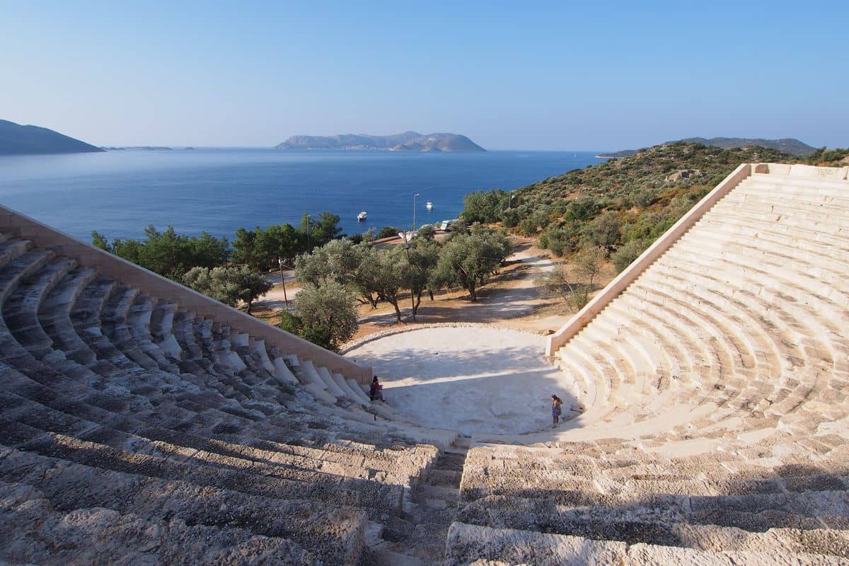
The Hellenistic theatre, restored in 2008, stands 500 metres from the centre of Kaş and seated 4,000 spectators. It is the only structure of its type in Anatolia with a sea front, and it has no proscenium, so nothing blocks the view of the sea. Kas tours pass the east wall, which collapsed possibly in the earthquake of 141. Kaş holds an annual arts festival, and jazz concerts take place in the theatre.
Kas tours find the King’s Tomb, a 4th century BCE Lycian Inscribed Mausoleum, on Uzunçarşı Street in the town centre. Its rock-cut base, about 1.5 m high, carries a poem in Milyan, or Lycian B, an extinct Anatolian language known from only three inscriptions, and the text has not been interpreted. The front pediment shows the builder as a bearded man leaning on a staff before his seated wife.
The English explorer Charles Fellows counted over 100 stone tombs at Antiphellos in April 1840. Local people later used the flat-sided stones as building material, so Kas tours now see the survivors:
- Doric Tomb: a rock-cut cube above the theatre with 4.5 m sides and a relief of dancing girls from the first half of the 4th century BCE.
- Rock tombs: tombs in the cliffs beyond the town, one with a Lycian inscription and a later Latin one.
- Temple: the lower parts of a 1st century BCE temple to an unknown god.
Which Kas tours sail to Kekova and the sunken city?
Kas tours to Kekova cross into the neighbouring Demre district, to the uninhabited island of Kekova and the sunken ruins on its northern side, then to Kaleköy, the site of ancient Simena below a castle, and Üçağız, the site of ancient Teimioussa.
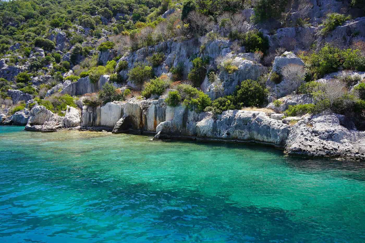
Kekova covers 4.5 km2 and was called Dolichiste in antiquity. The ancient town on its northern side was destroyed by an earthquake in the 2nd century, rebuilt under the Byzantine Empire and abandoned because of Arab incursions. Kas tours float over bays that hold wrecks of ancient ships and cities sunk by earthquakes, in water so clear that staircases and columns show from the boat.
The Turkish Ministry of Environment and Forest declared the 260 km2 Kekova region a specially protected area on 18 January 1990, and Kaş joined the protected Kekova marine area in December 2006. The first ban on diving and swimming has since been lifted, except over the sunken city. The region that Kas tours explore also takes in four ancient towns:
- Simena: grave inscriptions and coins date the town to the 4th century BC, and the remains of the Titus thermal baths lie in the water.
- Aperlae: a Lycian city that lasted about 1,300 years on the production of Tyrian purple dye from murex snails.
- Dolichiste: a narrow rock ridge where each house had a tank hollowed in the rock and lined with stucco.
- Teimioussa: a Lycian port town, also called Tristomon, with ancient tombs near Üçağız.
Kas tours reach Kaleköy, Turkish for “Castle’s village”, which lies between Kaş and Demre amid a Lycian necropolis that is partly under water. An East Roman castle, built in the Middle Ages to fight the pirates who nested in Kekova, overlooks the village and contains a small theatre carved into the rock. Kaleköy is a popular yachting destination, reached by sea or on foot from Üçağız, one km away, whose name means “three mouths” for its three exits to the open sea.


Which Kas tours dive the wrecks and reefs?
Kas tours for divers leave from more than 15 dive centres and schools, mostly at the port, for 50 dive spots with octopus and sea turtles, six artificial wrecks, a Douglas DC-3 plane and the Uluburun wreck reconstruction at the Kaş Archaeopark.
Kaş is one of the leading spots for scuba diving in Turkey, visited by beginners as well as advanced divers. Kas tours under water mix marine life with cultural heritage: the six artificial wrecks were sunk to create artificial reefs and dive spots.
Two wreck sites lie near the small islands at the edges of Kaş: an airplane from World War II and a cargo ship from the 1950s. The plane is a Douglas Dakota DC-3, deliberately sunk in July 2009, and it rests 70 ft down on a sandy bottom, where divers enter through the side hatch to see the pilot’s cabin. Divers on Kas tours also find an underwater sculpture of a shark by Kemal Tufan.
The Kaş Archaeopark Site is an experimental archaeology project that the Underwater Research Society (SAD) conducted in 2006, placing an interpretative reconstruction of the Uluburun wreck and its cargo under water. Kas tours to the site show a copy of a Late Bronze Age ship from the late 14th century BC, found close to the east shore of Uluburun, the Grand Cape. The original wreck in numbers:
- Discovery: the summer of 1982, by Mehmed Çakir, a sponge diver from Yalıkavak near Bodrum.
- Depth: between 44 and 52 metres, on a steep, rocky slope.
- Size: between 15 and 16 metres long.
Which Kas tours go to Kaputaş beach and Kalkan?
Kas tours along the D400 state road stop at Kaputaş, a small beach 20 km from Kaş and 7 km from Kalkan, then continue to Kalkan, an old fishing town in Antalya Province and the only safe harbour between Kaş and Fethiye.
Kaputaş Beach lies where an extremely narrow valley, towered over by steep cliffs and forests, meets the shore in a cove of the same name. Kas tours reach it on the D400, which crosses the heights above the cove, and visitors come for the natural setting and the views from that road. The sea gets deep close to the sand, and the municipality of Kalkan guards the beach.
Across the road, flowing water wore a deep, narrow canyon into the rock over thousands of years. Visitors walk into it from the beach under the road bridge when no water is flowing. Yachts on the Blue Cruise use the cove as a stopover, so Kas tours by boat and by road both reach Kaputaş.
Kalkan is a neighbourhood of the municipality and district of Kaş, and it was a town in its own right before the 2013 reorganisation. Its white-washed houses descend to the sea under brightly coloured bougainvilleas. The name means shield or turbot in Turkish. Kalkan was the only seaport for its surroundings until the 1970s, declined after the Fethiye road was built, and revived with tourism.
Kas tours to Kalkan also trace a Greek story. A Christian Greek community lived here until the 1920s, when the town was called Kalamaki. Its people left in 1923 in the exchange of populations between Greece and Turkey, settled mainly in Attica and founded a new Kalamaki there.
- Steps: 170 steps lead down from the road to Kaputaş Beach.
- Facilities: toilets, showers, a cafe bar and changing huts serve the beach.
- Canyon: the gorge behind the beach ends after about 200 metres.
- Sunshine: Kalkan averages 300 days of sunshine a year.
Which Kas tours visit Patara, Xanthos and the Letoon?
Kas tours to the Xanthos Valley combine Patara, once the capital of Lycia and its primary seaport, with the ruined city of Xanthos and the Letoon sanctuary, two sites 4 km apart that UNESCO declared a World Heritage Site together in 1988.
Kas tours reach Patara near Gelemiş, a village of Kaş district, and Patara Beach lies near the ancient city on the Turkish Riviera. Saint Nicholas was born in Patara around 270 AD. In antiquity the city was known for a temple and oracle of Apollo second only to Delphi, but archaeologists have not found the oracle site.
On Kas tours to Patara, the restored Bouleuterion recalls the Lycian League, the first such democratic union in history; the building was its assembly hall. Strabo counted 23 member cities, and the largest, including Xanthos, Patara, Myra and Tlos, held three votes each. Alexander Hamilton and James Madison cited the League at the Constitutional Convention of 1787.
The ruins of Xanthos stand on a hill on the left bank of the River Xanthos near Kınık, and Strabo called it the largest city in Lycia. In 42 BC Brutus besieged the city, and only 150 Xanthian men survived. Kas tours see the Harpy Tomb in its original place with replica reliefs; the Nereid Monument and the Tomb of Payava are in the British Museum.
The Letoon lies 4 km south of Xanthos, in the Fethiye district of Muğla Province. It was the sanctuary of Leto and her twins, Artemis and Apollo, and the religious centre of the Lycian League. Kas tours see three temples there, including the temple of Leto, rebuilt in its original setting between 2000 and 2007.
- Patara theatre: the theatre was rebuilt in 147 AD after an earthquake and held about 6,000 spectators.
- Patara lighthouse: the lighthouse was built in 60 AD under Nero and rises 26 m.
- Bouleuterion: the assembly hall of the League held about 1,400 people.
- Letoon trilingual: the stele found in 1973 carries texts in Lycian, Ancient Greek and Aramaic.
Which Kas tours visit Myra and the church of St Nicholas at Demre?
Kas tours to Demre cover three stops: the rock-cut tombs and Roman theatre of ancient Myra, the 6th-century Church of St Nicholas built over the saint’s burial place, and Andriake, the old harbour of Myra with its Museum of Lycian Civilizations.
Demre, the neighbouring district to Kaş, is the Lycian town of Myra and the home of Saint Nicholas; it was called Kale until 2005. Strabo listed Myra among the largest towns of the Lycian League. Kas tours visit the ancient site about 2 km north of the town centre.
On Kas tours, visitors see over one hundred Lycian rock-cut tombs in two groups, the River Necropolis and the Sea Necropolis, with facades that imitate Lycian wooden architecture and Greek temple fronts. When Charles Fellows saw the tombs in 1840, he found them still painted red, yellow and blue. An earthquake damaged the theatre in 141, and Opramoas of Rhodiapolis paid for its restoration.
The Church of St Nicholas, in Demre town centre, was built in AD 520 on the foundations of an older church where Nicholas had served as bishop. He attended the First Council of Nicaea in 325, and the legends of his secret gifts of gold coins became the foundation for Santa Claus. Inside, Kas tours see wall frescoes, an opus sectile floor of coloured marble and a desecrated sarcophagus thought to be his original burial place.
Merchants from Bari stole his bones in 1087, and they are now held in the Basilica of Saint Nicholas in Bari. The church stayed in Orthodox use until 1923, when the population exchange between Greece and Turkey required the remaining Ottoman Greeks of Demre to leave.
Andriake, 5 km southwest of Myra, was the city’s harbour until river silt choked the bay. There, Kas tours enter Hadrian’s granary, which opened in 2016 as the Museum of Lycian Civilizations. A heap of murex shells beside it shows that the port produced purple dye. The apostle Paul changed ships at this harbour around 59 AD on his way to trial in Rome.
- Tomb dates: the tombs date mainly to the 5th and 4th centuries BC.
- Theatre size: the theatre has 35 rows of seats for over 10,000 people.
- Granary size: the granary has seven rooms and measures 56 m by 32 m.
- Museum collection: the museum opened with 1,476 artefacts from across Lycia.
Which Kas tours go paragliding or sea kayaking?
Kas tours go paragliding from the mountains around the town and sea kayaking in the Kekova area to the east. Kaş sits at the foot of the 1,800 m Asas Dağı, and diving and paragliding rank among the leading sports of the district.
Paragliding Kas tours launch from the mountains that ring the town. Kaş spreads along Kaş Körfezi, a small Mediterranean bay below Asas Dağı, a spur of the southern Akdağ range. A paraglider is a lightweight, free-flying, foot-launched glider with no rigid primary structure, so each flight starts on foot.
Tandem paragliders carry the pilot and one passenger; they are larger than solo wings but otherwise similar. Harnesses have foam protectors under the seat and behind the back to soften failed launches or landings, and kids tandem harnesses come with special child-proof locks.
Sea kayaking Kas tours paddle in the Kekova area, which heads the list of popular adventures in Kaş. In December 2006, Kaş joined the specially protected Kekova marine area to preserve its rich biodiversity. A sea kayak, or touring kayak, is built for open water on lakes, bays and oceans, with a covered deck that takes a spray deck.
Solo sea kayaks measure 3.0 to 5.5 m, tandem craft reach 8 m, and one boat takes one to three paddlers. Kas tours reach Kekova by boat straight from Kaş, or by road to Üçağız and then by small boat. The coast around Kaş also holds 6 caves: the Blue Cave (Mavi Mağara), 18 km from town, the sea cave of Aşırlı Island and Güvercinlik Cave, known for its pigeons, are the best known.
Outdoor sports draw small group holidays from Europe and independent travellers, and trekking, mountaineering and rafting are growing with tourism. Kas tours on land and water cover five activities:
- Paragliding: flights from the mountains that surround Kaş.
- Sea kayaking: routes in the protected Kekova marine area.
- Canyoning: descents in the Kibris Canyon.
- Mountain biking: rides through the backcountry of the district.
- Trekking: the Lycian Way section from Phellos into Kaş and on towards Demre.
Which Kas tours cross to Kastellorizo?
Kas tours cross to Kastellorizo on the daily ferry from the marina at the south end of Kaş. Meis Express and Meis Ferry Lines both take 20 minutes to the Greek island, and a day trip from Kaş gives six hours ashore.
Kas tours cover a short gap. Kastellorizo, called Meis in Turkish, lies about 2 km off the Anatolian coast, and Cape Agios Stefanos, its nearest point, sits 2.25 km south of Kaş. Harbour to harbour, the Kastellorizo-Kaş swim covers 7.1 km, a race held every June since 2005 that ends in Kaş, the ancient Antiphellos.
Rhodes, the nearest part of the rest of Greece, lies 125 km away, and the four-hour trip by ship leads Kastellorizo islanders to do the bulk of their shopping in Kaş. Official crossings between Kaş and Kastellorizo have run since 2008. In the winter period, the Kastellorizo-Kaş line drops to 1 trip a week. Kas tours run as day trips from the Turkish side, since the reverse day trip is not possible.
Kas tours land at the harbour of Megisti, the official name of the island and of its only village, home to all 406 permanent residents. Megisti means “biggest” or “greatest”, yet the island covers only 11.98 km2, the smallest of the Dodecanese. The harbour fills the wide bay between Cape Agios Stefanos and Cape Nifti, and the village wraps around it:
- Quay: a waterfront that runs along all three sides of the harbour.
- Central square: Plateia Ethelondon Kastellorizou, at the midpoint of the eastern side near the vessel dock.
- Steps: 401 steps from the harbour up to Agios Georgios tou Vouniou.
- Blue Cave: a twenty-minute caique ride from the harbour, on the south-east side of the island.
Kas tours cross an EU border, so passports are checked at the Megisti police station under EU Regulation 2016/399. Travellers under 18 board only with a valid passport or identity card and a notarised written consent signed by both parents or legal guardians. Turkish citizens can use the gate visa, a Greek visa that is not a Schengen visa: it gives a single entry of up to 7 days for the island visited, needs a passport valid for at least six months with 2 blank pages, and requires exit from the same island.
Which local food do Kas tours taste?
Kas tours taste the cooking of Antalya Province, where Kaş lies: piyaz made with tahini, garlic, walnuts and boiled beans, şiş köfte cooked around a stick, spicy hibeş with cumin and tahini, and grida, the Mediterranean white grouper common in local fish dishes.
Kas tours meet the produce at its source. The Mediterranean climate of the district, with hot, dry summers and mild, wet winters, grows oranges, lemons and bananas. The lowlands raise cut flowers, fruit and vegetables, with crops grown all year round under glass, and the hillsides give honey and almonds. Fishing ranks among the leading livelihoods of Kaş, and the high mountain areas grow apples.
Market days suit food-focused Kas tours. Street markets are held by the old otogar on Friday and on the hill just west of the centre on Tuesday. On Fridays, Greek visitors from Kastellorizo cross to shop at the central city market, stocked with produce from the surrounding villages. The trade is old: in 1844, the port of Antiphellos traded livestock, butter, grain and coffee beans with the islanders.
Kas tours at the table follow the coastal Turkish menu. The cuisines of the Aegean, Marmara and Mediterranean regions are rich in vegetables, herbs and fish. In summer, a cold dish of vegetables cooked in olive oil, zeytinyağlı yemekler, takes the place of soup, and fish comes grilled, fried or steamed by the buğulama method with lemon and parsley. Coastal seafood meze includes stuffed mussels, fried mussels and fried kalamar with tarator sauce, served with rakı in meyhanes. Sweets and snacks complete the menu:
- Bağaça: a spiced tahini pastry from Antalya.
- Yanıksı dondurma: a burnt-milk ice cream.
- Tirmis: boiled lupin seeds eaten as a snack.
- Haytalı: starch pudding and ice cream in rose water with syrup.
Kas tours that cross to Kastellorizo eat in the port village, where restaurants serve seafood meze, slipper lobster, octopus in tomato sauce with shallots and fresh shrimp. Back in Kaş, Republic Day on 29 October brings music, dancing and rakı to the town square and marks the end of the season.
How do visitors reach Kas on Kas tours?
Kas tours begin on the road, because Kas has no airport of its own. Visitors land at Dalaman Airport to the west or Antalya Airport to the east, then reach the town by transfer, taxi or intercity bus along the D400 coast road.
Dalaman Airport (DLM) is the closest, with seasonal package flights from Europe and the UK, and it serves Kas, Kalkan, Fethiye and Marmaris. Its new terminal handles international flights and the old terminal handles domestic routes. Airport shuttles to Fethiye and Marmaris depend mainly on domestic arrivals, so passengers on foreign flights book transfers or taxis for Kas tours. Fethiye, the resort west of Kas on the same D400 coast road, is the base for Fethiye tours, and local coast buses from Fethiye reach the old otogar in Kas.
Antalya Airport (AYT) lies 13 km northeast of Antalya city centre, and Kas sits 168 km west of the city. City bus 600 links the airport with the Otogar, the city bus station, and the Antalya Tramway also reaches the airport. From the Otogar, travellers on Kas tours board buses signed “Kaş” or “Kalkan”, which leave every 45 minutes and take about 4 hours.
- Istanbul coaches: 2 or 3 departures a day, 15 hours 30 minutes via Izmir, Muğla and Fethiye.
- Coach companies: Pamukkale and Flixbus on the Istanbul route.
- Bus terminal: Kaş Otobüs Terminali, 5 km east of town on the highway to Demre.
- Town transfer: a dolmuş to the old otogar on the main square off Atatürk Boulevard.
- Sea link: a daily Turkish ferry from the Greek islet of Kastellorizo.
When do Kas tours run best?
Kas tours run best between April and October, the tourist season of the town, and September gives warm seas without the sweltering summer heat. Kas has a Mediterranean climate of hot, dry summers and mild, wet winters, on about the latitude of Tunis.
NOAA climate normals for 1991 to 2020 give Kas an average August high of 32.9 °C and a July high of 32.5 °C, against 15.9 °C in January. Rain totals just over 834 mm a year across 59.9 rain days, and December is the wettest month at over 197 mm. June, July and August each record under 3 mm, which keeps Kas tours dry in high summer.
Antalya, the provincial capital, records a mean sea temperature of 16 °C in winter and 27 °C in summer, the range that frames swimming and diving on Kas tours. The mild climate lets oranges, lemons and bananas grow in the district, and over a dozen boat-trip operators ply from the Kas harbour.
- Spring: the best Lycian Way hiking, with snow on the hills and flowers across the landscape.
- June: the 7.1 km Kastellorizo-Kas swim race, held each year since 2005.
- October and November: enjoyable hiking as heat and humidity ease.
- 29 October: Republic Day music and dancing in the town square, the end of the season.
What history do Kas tours tell?
Kas tours tell the story of Habesos, a Lycian town that became Antiphellos, the port of inland Phellos, under the Greeks and Romans. Arab raids, Seljuk rule under the name Andifli and the Ottomans followed, and the Greek population left in 1923.
The Lycians had settled at Habesos by the 6th century BCE, a date confirmed by architectural pieces now in the Antalya Museum, and the Persians invaded around the middle of that century. Kas tours also cover the Lycian League, a union of 23 cities in which the largest held three votes and medium ones two; the city held one vote and minted its own coins.
The Greek name Antiphellos first appears on a 4th-century-BCE tomb inscription in Kas, and the city became the largest in the region as Phellos declined. Rome validated Lycian home rule under the League in 168 BC, and the emperor Claudius annexed Lycia in 43 AD. The earthquake of 141 sent a tsunami along the Lycian coast, and Opramoas of Rhodiapolis gave funds to the city in the Roman period.
In 395 AD the province passed to the Eastern Roman Empire, and Antiphellos became a bishopric under the see of Myra; its bishop Theodorus attended the Council of Chalcedon in 451. Arab incursions hit the town, the Seljuk Sultanate of Rum then annexed it as Andifli, and Ottoman rule followed. By 1828 Antiphellos was all but deserted, and the town was built up over the next decades.
The convention on the exchange of Greek and Turkish populations, signed at Lausanne on 30 January 1923, sent the Greek population of the area to Greece, and the loss hit the economy of Kastellorizo heavily. The Yeni Camii, or New Mosque, at the foot of the peninsula was a Greek Orthodox church. Kas tours today follow a tourism boom that began in the early 1990s, with visitors mainly from the UK and Germany.
Frequently Asked Questions
How large is the district that Kas tours cover?
Kas District covers 1,750 km² and holds 54 neighbourhoods, from Ağullu to Yuvacık. It had 62,866 residents in 2022, tenth by population among Antalya Province districts, and the town itself has 9,084 inhabitants. Kınık and Ova are the other larger settlements, and tourism is the main source of income.
Which land-based Kas tours suit active travellers?
Land-based Kas tours cover mountain biking in the backcountry, canyoning in the Kibris Canyon and trekking on the Lycian Way. Briton Kate Clow conceived the trail, which opened in 1999 and runs over 760 km from Hisarönü near Fethiye to Antalya Province. Red and white stripes mark it, and two stages meet in Kas.
Which inland ruins do Kas tours reach?
The district holds the ruins of Komba in Gömbe village, Nisa, Kandyba, Phellos, Istlada, Apollonia, Isinda and Kyaneai. Phellos keeps acropolis walls and tombs north of Çukurbağ. Isinda lies by Belenli village, and its people left for Antiphellos around the 1st century AD. Kyaneai, three ruined cities near the D400, keeps a theatre and tombs.
How do visitors get around between Kas tours?
Kas is small and walkable. Dolmuş minibuses to the Çukurbağ peninsula leave from a stop by the Merkez Süleyman Cami mosque near the waterfront, and other routes follow the coast to Kalkan and Demre. Midnight buses to the peninsula no longer run, and Kas and the coast road have 4G from all Turkish carriers.