
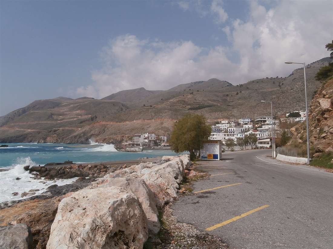
Chora Sfakion is the small, proud port town and capital of the wild Sfakia region on the south coast of Chania in Crete, about 75 kilometres from Chania, the ferry gateway to Loutro, Agia Roumeli and Gavdos. Plan the whole trip with Greece Tours.
This guide covers Chora Sfakion in full: what and where it is, why it is the ferry hub of the roadless south coast, how it connects to the Samaria Gorge return, the fierce Sfakian character and history, the beaches, the town, the Imbros and Aradena gorges, the boat to Loutro, Frangokastello, the Sfakian pie and food, where to eat and stay, how to get there over the mountains, the best time, and whether Chora Sfakion is worth visiting.
What is Chora Sfakion in Crete?
Chora Sfakion is the small port town and administrative capital of the Sfakia region on the south coast of Crete, the ferry gateway to the roadless villages of Loutro and Agia Roumeli and the island of Gavdos, Europe’s southernmost point.
Chora Sfakion sits at the foot of the White Mountains (Lefka Ori), where the peaks drop straight into the Libyan Sea. The town holds fewer than 300 permanent residents, yet it governs a mountain territory that stretches from the coast up to summits above 2,000 metres. Sfakia is the driest and most rugged corner of the Chania regional unit, a landscape of gorges, bare rock and isolated coves.
The town functions as the transport heart of the entire southern seaboard. West of Chora Sfakion the coastline carries no road at all, so the settlements of Loutro, Agia Roumeli, Marmara and Glyka Nera depend on the ferries that leave the Chora Sfakion quay. Walkers finishing the Samaria Gorge, day-trippers heading to Gavdos and travellers seeking the emptiest beaches in Crete all pass through this one harbour.
Chora Sfakion also anchors the E4 European long-distance path as it crosses the south coast. The town’s tavernas, rooms and single fuel supply make it the last full-service point before the trail runs west into country reachable only on foot or by boat. This combination of role and remoteness defines the place: a compact working port that opens the door to a coastline the road network never touched.
The name Sfakia attaches both to the town and to the wider mountain province around it. Chora, the Greek word for the chief settlement of a district, marks Chora Sfakion as the seat of the region rather than a mere fishing hamlet. From here the mountain villages of Anopoli, Aradena, Askifou and Asfendou look down on the sea, and their footpaths, gorges and old shepherd trails all lead back toward the harbour. The town holds the region’s ferry office, its bus stop and its post, making it the single point where the isolated south coast touches the outside world.
Where is Chora Sfakion and how far is it from Chania?
Chora Sfakion lies about 75 km south of Chania on the Libyan Sea coast, reached by the mountain road through the Imbros Gorge valley and Vryses. The drive takes about 90 minutes, and a daily KTEL bus links the town to Chania bus station.
The route leaves Chania eastward to Vryses on the north-coast highway, then turns south into the interior. The road climbs the Krapi valley, crosses the Askifou plateau at around 730 metres, and threads down past the mouth of the Imbros Gorge before dropping in tight switchbacks to the sea at Chora Sfakion. The descent delivers a wide view of the Libyan Sea and the small harbour below.
The KTEL Chania\u2013Sfakia bus connects the town with the regional network, timed to meet the ferries and the Samaria Gorge traffic. From Chora Sfakion the same operator runs coaches on to Frangokastello and inland to Anopoli and the trailheads above Loutro. Drivers reach the town in a single hour and a half from Chania airport or the port at Souda.
Chora Sfakion stands roughly 40 km from Frangokastello to the east and about 35 km below the Omalos plateau, the northern entrance to the Samaria Gorge, though no direct coastal road joins them. Travellers coming from the wider region pass through Chania first; the north-coast city remains the gateway to western Crete, and its own attractions repay a stop on the way south. See our guide to Chania for the approach.
The Imbros Gorge that the road skirts is a walk in its own right. The 8 km ravine drops from the Askifou plateau toward the coast, narrowing to a gap barely two metres wide between rock walls hundreds of metres high, and its lower end lies a short bus ride from Chora Sfakion. Many travellers pair the gorge descent with the town, walking down in the morning and reaching the harbour in time for an afternoon swim or the evening ferry.
Why is Chora Sfakion the ferry hub of the south coast?
Chora Sfakion is the ferry hub because the south coast west of the town carries no road: the villages of Loutro and Agia Roumeli, the island of Gavdos and the return leg of the Samaria Gorge walk are reached only by the boats that sail from its quay.
The Anendyk line operates the coastal ferries out of Chora Sfakion. The core service runs west along the shore, calling first at Loutro, then continuing to Agia Roumeli at the foot of the Samaria Gorge. A separate boat crosses open water to Gavdos, the small island 37 nautical miles south that marks the southernmost land in Europe. In the peak season a fast catamaran and slower vehicle ferries share the timetable.
The harbour’s importance rests on plain geography. The White Mountains fall so steeply into the sea that no coast road was ever cut west of the town. Loutro has no vehicle access of any kind, and Agia Roumeli sits at the seaward mouth of a national park gorge. For these places the ferry is not a scenic option but the only mechanical link to the rest of Crete.
Ferry departures cluster around the arrival of the Chania buses and the finish of the Samaria walk, so the quay fills and empties in waves through the day. Tickets are bought at the Anendyk office on the waterfront. The village of Loutro, a car-free bay of white houses a short sail west, is the most popular first stop and returns walkers to Chora Sfakion by the same fleet.
The Gavdos run is the longest and least frequent of the sailings. The crossing to the small island takes about two hours from Chora Sfakion, and the boat calls at the port of Karave before the beaches of Sarakiniko and Agios Ioannis. Gavdos holds a scatter of tavernas, a lighthouse and the wooden chair marking the southernmost point of Europe, and the ferry is its lifeline for supplies and visitors alike. The schedule tightens in winter, when heavy seas cut the island off for days at a stretch.
How does Chora Sfakion connect to the Samaria Gorge?
Chora Sfakion closes the Samaria Gorge circuit: walkers descend the gorge to Agia Roumeli on the coast, then take the ferry east to Chora Sfakion, where a waiting coach carries them back over the mountains to Chania. The port is the pivot of the standard day trip.
The Samaria walk runs one way, north to south. Groups start at Xyloskalo on the Omalos plateau, descend 16 km through the national park, and finish at Agia Roumeli beside the sea. Because Agia Roumeli has no road, the only exit is the boat. The afternoon ferries sail east to Chora Sfakion, timed so that hikers connect straight onto the return bus.
At Chora Sfakion the coaches line the harbour front to meet each ferry. The KTEL service climbs back through Imbros and Askifou to Chania and the north-coast resorts, completing a loop that begins and ends far from the port yet turns on it. Walkers who miss the last boat stay overnight in Agia Roumeli and cross the next morning.
The gorge itself is the most walked long-distance path on Crete, and its logistics are built around this single southern harbour. Our full account of the Samaria Gorge sets out the descent, the timings and the ferry connection through Chora Sfakion in detail.
What is the Sfakian character and history of Chora Sfakion?
Chora Sfakion carries a reputation for fierce independence rooted in Sfakia’s mountain isolation. The region resisted Venetian and Ottoman rule, produced the rebel leader Ioannis Daskalogiannis, and holds a long tradition of clan loyalty, hospitality and hard mountain self-reliance.
Sfakia’s terrain kept outside rulers at arm’s length for centuries. The White Mountains gave the Sfakians a stronghold no army held for long, and the region became a byword across Crete for revolt. Ioannis Daskalogiannis, a shipowner from the mountain village of Anopoli above Chora Sfakion, led a rising against the Ottomans in the 18th century and was flayed alive at Heraklion after his surrender; his story survives in a long oral ballad.
The Sfakian identity blends this rebel history with a strict code of hospitality. Travellers are received with raki, hard cheese and the region’s honeyed sfakiani pita pancake. The clan structure that once drove the vendetta feuds of local legend also underpins a fierce loyalty to guests and neighbours, and the black-shirted mountain dress and high leather boots remain part of the Sfakian self-image.
Chora Sfakion also earned a place in the memory of the Second World War. After the fall of Crete, thousands of Allied troops retreated across the White Mountains and were evacuated by the Royal Navy from the beach and quay of the town over successive nights. A memorial on the waterfront marks the operation.
The mountain villages above the town preserve the older Sfakian world. Anopoli, the birthplace of Daskalogiannis, sits on a plateau reached by a road that climbs the cliff behind Chora Sfakion in a series of hairpins. Aradena, now half abandoned, guards a gorge crossed by a high steel bridge, and the drystone shepherd huts, threshing floors and family towers scattered across the uplands trace a pastoral economy built on sheep, cheese and hard mountain grazing. This inland core feeds the town its produce, its meat and its identity.
What are the beaches at Chora Sfakion?
Chora Sfakion has the pebble town beach of Vrisi beside the harbour, the sand-and-shingle cove of Ilingas a short walk west, and a string of clear coves along the road toward Loutro, all set against the abrupt cliffs of the Libyan Sea shore.
Vrisi is the closest beach, a curve of grey pebbles and clean deep water reached on foot from the town centre. A freshwater spring feeds the shore, which gives the beach its name and keeps the shallows cool. Tavernas back the sand, so swimmers step from the water to a table without leaving the harbour edge.
Ilingas lies about 2 km west at the mouth of the Ilingas Gorge, a sheltered pocket of sand and shingle below tall cliffs. Beyond it the beaches of Glyka Nera (Sweetwater), where cold springs bubble up through the pebbles, and Marmara at the exit of the Aradena Gorge sit along the same coast, reached on the coastal footpath or by the Loutro ferries.
The water off this shore runs a deep blue and stays clear through the season, sheltered by the mountain wall from the north wind that scours the rest of Crete. The beaches carry few facilities beyond the town itself, which keeps them quiet and holds the crowds to the harbour front.
Reaching the western coves rewards the effort. The old footpath from Chora Sfakion to Loutro traces the cliff edge above the sea, passing Ilingas and Glyka Nera on the way, a walk of about two hours over rock and scree. The ferries offer the alternative, dropping swimmers at Loutro or Marmara for a morning on the sand and collecting them in the afternoon. This mix of boat and trail keeps the finest beaches of Sfakia within reach yet out of the path of the tour coaches.
What is Chora Sfakion town like?
Chora Sfakion is a compact working harbour of stone and whitewash: a single waterfront lined with tavernas and rooms, a small quay for the ferries and fishing boats, and the sheer wall of the White Mountains rising straight behind the roofs.
The town wraps around its harbour in a tight crescent. The seafront holds the ferry office, a handful of family tavernas serving grilled fish and the local lamb, and simple guesthouses stacked on the slope above. A short lane climbs to the upper village and the church, and beyond the last house the mountain rises without interruption toward the peaks.
Life in Chora Sfakion follows the rhythm of the boats. Mornings bring the ferry passengers and the Samaria coaches, the quay fills, and by evening the day-trippers move on and the harbour returns to the fishermen and the resident families. The town keeps its working purpose and refuses the resort trappings of the north coast.
Chora Sfakion suits travellers who want a base for the wild south rather than a beach holiday. From its rooms the E4 path, the coastal ferries, the gorges of Imbros and Aradena and the empty coves west toward Loutro all open out, and the town itself stays quiet under its mountain, a small proud capital at the edge of the Libyan Sea.
The kitchens define the town as much as the harbour. Sfakian cooking centres on lamb and goat raised on the mountains, hard graviera and mizithra cheese, wild greens and the thin fried sfakiani pita filled with soft cheese and drizzled with local honey. Raki, the clear grape spirit of Crete, arrives with the bill and stands in for a welcome. Diners take these plates at tables set almost on the water, with the ferries coming and going a few metres away and the mountain glowing red above the roofs at sunset.
What is there to do in Chora Sfakion?
Chora Sfakion rewards travellers who board its boats, walk its gorges, swim its pebble coves and eat Sfakian food at the harbour. The town runs at a slow pace, and its position on the wild south coast turns every departure into an adventure.
The village stacks its whitewashed houses against a steep mountain wall, and the waterfront forms the centre of daily life. Fishing boats tie up beside the passenger caiques, tavernas set their tables at the water’s edge, and the road ends here because the mountains block any coastal route east or west. This dead-end geography makes Chora Sfakion a launch point rather than a thoroughfare, so the town keeps a settled rhythm that Chania’s busier resorts lose in high season.
Activity here divides into three strands. The boats carry walkers to Loutro, to Agia Roumeli at the mouth of the Samaria Gorge, and to the pink sand of Marmara. The footpaths climb the Imbros and Aradena gorges and trace the Sfakia coast on the E4 European long-distance trail. The tavernas serve mountain lamb, myzithra cheese and the honey-drizzled Sfakian pie that carries the region’s name. A traveller fills a full week without leaving the immediate coast, and the surrounding villages of the Sfakia district add hill walks, chapels and mountain springs.
What gorges hike from Chora Sfakion?
Chora Sfakion opens three walks: the Imbros Gorge that descends the mountain road above the town, the deep Aradena Gorge to the west, and the coastal path along the shore to the car-free village of Loutro. Each starts within a short transfer of the port.
The Imbros Gorge runs eight kilometres from the village of Imbros down to Komitades, a hamlet three kilometres from Chora Sfakion. The walk drops through a narrow limestone corridor where the walls close to two metres apart, and it takes two to three hours on a well-marked path with a gentle gradient. Walkers ride the KTEL bus or a taxi up to Imbros and finish at the coast, and the shorter length and softer descent make it the calmer alternative to the famous Samaria Gorge.
The Aradena Gorge cuts a deeper, wilder line to the west, spanned by an iron bridge that draws bungee jumpers to its 138-metre drop. The trail from Aradena village reaches the sea at Marmara Beach, where a boat returns walkers to Loutro and Chora Sfakion. Between the gorges, the coastal footpath links Chora Sfakion to Loutro in about two hours, tracing the cliffs above the sea and passing the ruined fort at the headland. All three routes connect to the E4 trail, and the tourist information at the harbour posts the day’s boat times that close each loop.
What is the boat trip to Loutro from Chora Sfakion?
The boat to Loutro is a short crossing of about ten minutes from Chora Sfakion to a car-free fishing village reachable only by sea or on foot. The caique runs through the day in season and passes pebble coves and clear turquoise water on the way.
Loutro sits in a sheltered horseshoe bay six kilometres west of Chora Sfakion, and no road reaches it. Blue-and-white houses ring a calm harbour, tavernas line the single waterfront lane, and the absence of cars gives the village a quiet that the road-connected towns lose. The crossing costs a few euros each way, and the timetable posts at the Chora Sfakion quay and on the boat operators’ boards beside the ferry berth.
The route between the two ports passes beaches that walkers reach on the coastal path. Sweetwater Beach lies halfway, named for the fresh springs that seep through its shingle, and swimmers dig the pebbles to reach cool water at the shoreline. Beyond Loutro, boats continue to Marmara Beach at the foot of the Aradena Gorge and to Glyka Nera, so a single day strings together the crossing, a swim and a gorge walk before the last return sailing to Chora Sfakion.
What is Frangokastello near Chora Sfakion?
Frangokastello is a Venetian fortress that stands square on a flat sandy shore fourteen kilometres east of Chora Sfakion. Its honey-coloured walls rise straight from the beach, and the site carries the Drosoulites legend of ghostly figures that appear at dawn in late spring.
The Venetians raised the fort to hold the rebellious Sfakia coast, and its four corner towers and intact curtain walls survive in clear outline against the sea. The Lion of Saint Mark still marks the main gate. The building fronts a broad shallow bay where the water warms early and the sand shelves gently, so the beach draws families who pair a swim with a walk around the ramparts.
The Drosoulites legend gives Frangokastello its fame. Local accounts describe a procession of shadowy human shapes that moves across the plain toward the fort at first light on the anniversary of a battle fought here between Cretan fighters and Ottoman forces. The name means “dew men”, and the phenomenon links to the humid dawn air of late May. A road connects Frangokastello to Chora Sfakion in twenty minutes, which puts the fortress within an easy half-day from the port.
What Sfakian food do you eat in Chora Sfakion?
Chora Sfakion serves the Sfakian pie, a thin pan-fried cheese pastry drizzled with honey, alongside fresh myzithra cheese, spit-roast mountain lamb and the grape spirit tsikoudia. The food draws on the pastoral tradition of the Sfakia highlands and defines the region’s table.
The Sfakian pie, sfakiani pita, is the signature dish. A cook rolls soft myzithra cheese into a paper-thin round of dough, fries it in a dry pan until golden, and pours local thyme honey over the top. The result balances the tang of the cheese against the sweetness of the honey, and tavernas serve it as a snack, a starter or a dessert. Every waterfront kitchen in Chora Sfakion prepares it fresh to order.
The wider Sfakian table reflects the mountains behind the town. Shepherds graze sheep and goats on the high pastures, so lamb and goat roast slowly over wood or turn on the spit, and fresh and sour myzithra cheeses appear in salads and pastries. Wild greens, snails and barley rusks fill out the meze plates, and the meal ends with tsikoudia, the clear Cretan grape spirit that a host pours as a matter of course. The honey, the cheese and the herbs all come from the surrounding slopes.
Where do you eat in Chora Sfakion?
You eat along the harbour front in Chora Sfakion, where a line of family tavernas sets tables at the water’s edge and serves grilled fish, Sfakian lamb and the honeyed cheese pie. The kitchens face the ferry berth, so a meal doubles as a view of the boats.
The waterfront tavernas form a continuous row facing the quay, and each cooks the Sfakian standards: the pan-fried pie, roast and grilled meats from the mountain flocks, fresh myzithra, and fish landed by the boats moored a few metres away. Prices stay grounded because the town serves ferry passengers and walkers rather than a package-resort crowd, and the tables turn steadily through the day as boats arrive and depart.
Timing shapes the harbour scene. Midday brings the walkers off the Samaria and Imbros boats, hungry after their descents, and the tavernas fill for a fast lunch before the afternoon sailings. Evening slows the pace, and diners linger over tsikoudia as the light drops behind the mountains and the ferries fall silent for the night. Family kitchens run most of the tables, and the recipes pass down the generations that have fished and herded this coast.
Where do you stay in Chora Sfakion?
Chora Sfakion offers small family-run hotels and rented rooms clustered around the harbour and up the slope behind it. The nights stay quiet because the road ends at the town, and demand rises in summer, so booking ahead secures a sea-view room.
The accommodation runs to modest hotels, guesthouses and studio rooms rather than large resorts, and the scale suits the town. Many rooms overlook the harbour or the open sea, and the terraces catch the sunset over the water. The absence of through traffic and nightlife means the town settles into deep quiet after the last ferry, which draws walkers who want an early start and a full night’s rest. For a wider spread of bases across the region, the guide to where to stay in Chania sets out the options from the north-coast city to the southern villages.
Summer fills the rooms fast, because Chora Sfakion serves as the overnight stop for walkers finishing the Samaria and Imbros gorges and for travellers touring the south coast. Booking a week or more ahead in July and August protects a room, while the shoulder months of May, June, September and October open more choice at calmer prices. Loutro, a short boat ride west, holds additional rooms for travellers who want the car-free village as a base.
How do you get to Chora Sfakion from Chania?
Chora Sfakion lies about 75 kilometres south of Chania, a drive of roughly ninety minutes over the White Mountains through the Imbros gorge road. The KTEL bus runs the same route daily, and the descent to the coast delivers wide views of the Libyan Sea.
The drive climbs from the north-coast plain onto the Askifou plateau, then threads down the mountain road past the village of Imbros before the final descent to the sea at Chora Sfakion. The route is paved throughout and passes the trailhead where gorge walkers begin the Imbros descent, so drivers pair the transfer with a walk by leaving the car and riding the bus back up. The road links directly to the coastal city and its wider network described on the Chania hub.
The KTEL bus connects Chania’s central station to Chora Sfakion through the day in the summer season, with the timetable thinning outside it. The service times its arrivals to the ferry departures for Loutro and Agia Roumeli, so bus passengers step off and onto a boat, and returning walkers off the Samaria Gorge catch the evening bus back to Chania. Travellers who prefer a guided approach find the town featured among the day trips from Chania, which package the mountain crossing with the coastal boats.
When is the best time to visit Chora Sfakion?
The best time to visit Chora Sfakion runs from May to October, when the ferries sail daily, the gorges open and the sea warms for swimming. The shoulder months of May, June, September and October combine reliable boats with thinner crowds and mild mountain walking weather.
The boat network drives the calendar. Ferries to Loutro, Agia Roumeli and Marmara run on full timetables through the warm months, and the Samaria Gorge opens for through-walkers from spring to autumn, which fills the returning boats to Chora Sfakion. Outside this window the sailings drop to a skeleton service, the gorge closes for winter flooding, and the town returns to its year-round fishing rhythm.
July and August bring the strongest sun, the warmest sea and the fullest tavernas, and the heat pushes gorge walkers to early starts. The shoulder months trade a degree of warmth for space: the coastal path and the Imbros and Aradena gorges walk comfortably in the softer temperatures, the rooms open up, and the harbour keeps its unhurried pace. Late spring adds the draw of the Drosoulites dawn at nearby Frangokastello, which centres on the humid mornings of that season.
Is Chora Sfakion worth visiting?
Chora Sfakion is worth visiting as the gateway to Crete’s wild south coast and the Sfakian mountains. The town combines boat access to car-free Loutro and the Samaria Gorge, three gorge walks, honest Sfakian food and a slow harbour pace found nowhere on the busier north.
The value lies in the town’s position. From this single port, walkers reach the deep gorges of Imbros and Aradena, board boats to Loutro, Marmara and Sweetwater Beach, and finish the Samaria descent at Agia Roumeli before sailing home. The Venetian fortress at Frangokastello, the tsikoudia and the honey-drizzled pie fill out a stay, and the dead-end road keeps the nights quiet in a way that the resort coast surrenders.
Chora Sfakion suits travellers who want the mountains and the Libyan Sea over sunbeds and nightlife. It rewards a base of two or three nights that strings together the boats, the walks and the food, and it anchors any tour of the Sfakia region and the wider south of Chania. For the walker, the swimmer and the traveller after the authentic Crete of the shepherds and the sea, the port at the end of the mountain road stands as one of the island’s finest gateways.
Frequently Asked Questions
What is Chora Sfakion in Crete?
Chora Sfakion is the small port town and capital of the Sfakia region on the south coast of Crete, about 75 kilometres from Chania. It is the ferry hub for the roadless south coast, with boats to Loutro, Agia Roumeli, Gavdos and the Samaria Gorge return.
How does Chora Sfakion connect to the Samaria Gorge?
Samaria Gorge walkers finish at Agia Roumeli on the south coast and take the boat east to Chora Sfakion, then the KTEL coach back over the mountains to Chania. Chora Sfakion is the end point of the classic Samaria day trip.
Is Chora Sfakion worth visiting?
Chora Sfakion rewards visitors as the gateway to the wild Sfakia coast and mountains, with boats to Loutro and Agia Roumeli, the Imbros and Aradena gorges, Frangokastello, and hearty Sfakian food. Its proud, remote character sets it apart from the north coast.