
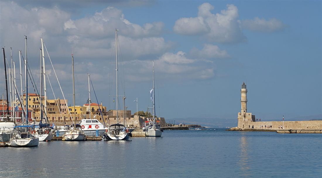
Chania old town is the walled Venetian-Ottoman quarter around the harbour of Chania in western Crete, a labyrinth of alleys ringed by the Venetian sea walls, crowned by the Egyptian lighthouse and the domed Mosque of the Janissaries on the waterfront. Plan the whole trip with Greece Tours.
This guide covers Chania old town in full: the Venetian harbour and lighthouse, the Mosque of the Janissaries, the Firka Fortress and Maritime Museum, the Neoria arsenals, the Topanas and Splantzia quarters, the walls, the covered market and the leather street, where to eat and stay, the evening stroll, how to get there and park, and the day trips to the Samaria Gorge and Balos.
What is Chania old town?
Chania old town is the walled Venetian-Ottoman core of Chania on the north-west coast of Crete, a dense maze of stone alleys wrapped around a horseshoe harbour, ringed by ramparts and layered with Venetian, Ottoman, and Byzantine building.
The old town covers the ground between the Venetian harbour to the north and the surviving line of the land walls to the south. Its streets follow no grid. Narrow lanes twist between two-storey and three-storey houses of honey-coloured stone, opening without warning onto small squares, a church front, a fountain, or a stretch of open sea. The plan is medieval: the Venetians laid the framework across four centuries of rule, and the Ottomans reshaped it across the following two and a half centuries, adding minarets, wooden upper storeys, and enclosed balconies that lean over the paving.
Chania sits on the site of ancient Kydonia, one of the principal city-states of Bronze Age and Classical Crete, and the hill of Kastelli above the harbour holds Minoan foundations beneath the later stone. The Venetians named the harbour district and its fortified heights, walled the whole settlement, and made Chania the seat of their rector in western Crete. That inheritance is why the old town reads as a single continuous monument rather than a collection of separate sights: the harbour, the fortress, the mosque, the arsenals, and the quarters behind them belong to one fortified city.
The old town divides into named quarters, each with its own texture. Topanas rises on the western side above the harbour, once the Christian and grander Venetian district. Splantzia spreads to the east around a Byzantine street plan and an Ottoman core. Kastelli crowns the low hill at the centre, the oldest inhabited ground. Evraiki, the former Jewish quarter, threads the lanes behind the western waterfront. Walking the old town means moving through all of these in the space of an afternoon.
What is the Venetian harbour of Chania?
The Venetian harbour of Chania is the horseshoe-shaped port built by the Republic of Venice as a naval and trading base, a curved basin of still water enclosed by a long stone breakwater, edged by a waterfront of tall painted houses that now front cafes, tavernas, and small hotels.
The Venetians dug and fortified the harbour across the fifteenth and sixteenth centuries to shelter their galleys and merchant ships and to hold the western approach to Crete. The basin is small and shallow, which is why the modern commercial port of Chania lies away to the west at Souda: the old harbour serves fishing boats, pleasure craft, and the taxi boats that run tours along the coast. Its shallowness preserved it. The waterfront never gave way to industrial docks, so the arc of Venetian and Ottoman facades survives almost unbroken.
The promenade runs the full curve of the quay, from the Firka Fortress at the western entrance, past the Mosque of the Janissaries at the inner bend, along the eastern arm to the arsenals. A stone breakwater carries the walk out to the lighthouse at the harbour mouth. The waterfront buildings stand three and four storeys tall in ochre, terracotta, and faded blue, their ground floors opened as tavernas and their upper floors as balconied rooms looking over the water. The harbour is the single most photographed scene in Chania, and the promenade is where the life of the old town concentrates at dusk.
Behind the northern edge of the quay, the Neoria arsenals and the customs houses mark the working core of the Venetian port. The harbour was engineered as a complete naval installation: a defended entrance, a sheltered basin, dry-dock vaults for building and repairing ships, and warehouses for the grain, oil, and wine that Venice shipped from Crete. What survives is the shell of that system, emptied of its fleet and given over to the promenade.
What is the Chania lighthouse?
The Chania lighthouse is the stone tower that stands at the very mouth of the Venetian harbour on the end of the breakwater, a slender minaret-shaped structure about twenty-one metres tall, rebuilt by the Egyptians in the nineteenth century and now the emblem of the city.
The Venetians raised the first lighthouse on this spot in the sixteenth century to guide ships into the narrow harbour entrance at night. That original tower fell into ruin under later rule. The present lighthouse dates from the period of Egyptian administration of Crete under Mehmet Ali, which is why it is called the Egyptian lighthouse. Its builders gave the shaft the tapering profile of a minaret, a form that ties it to the Ottoman century of the town. It rises in three stages from a wide stone base to a lantern room, the whole tower faced in pale masonry that catches the light at sunset.
A walk out to the lighthouse follows the full length of the harbour breakwater, a curving stone mole that separates the basin from the open sea. The path leaves the promenade near the Firka Fortress, passes a small chapel and the ruins of the old harbour defences, and runs out along the water to the tower at the tip. The lighthouse itself is closed to the interior, but the walk is the point: it delivers the finest view back across the harbour to the waterfront, the mosque dome, and the White Mountains rising behind the town. The round trip along the breakwater takes about twenty minutes at a slow pace.
The lighthouse anchors the harbour view in every direction. From the eastern arsenals it stands against open water; from the western fortress it frames the harbour entrance; from the breakwater it turns and points the eye back at the town. It is the fixed landmark of Chania, printed on postcards, painted on taverna signs, and used as the symbol of the city itself.
What is the Mosque of the Janissaries?
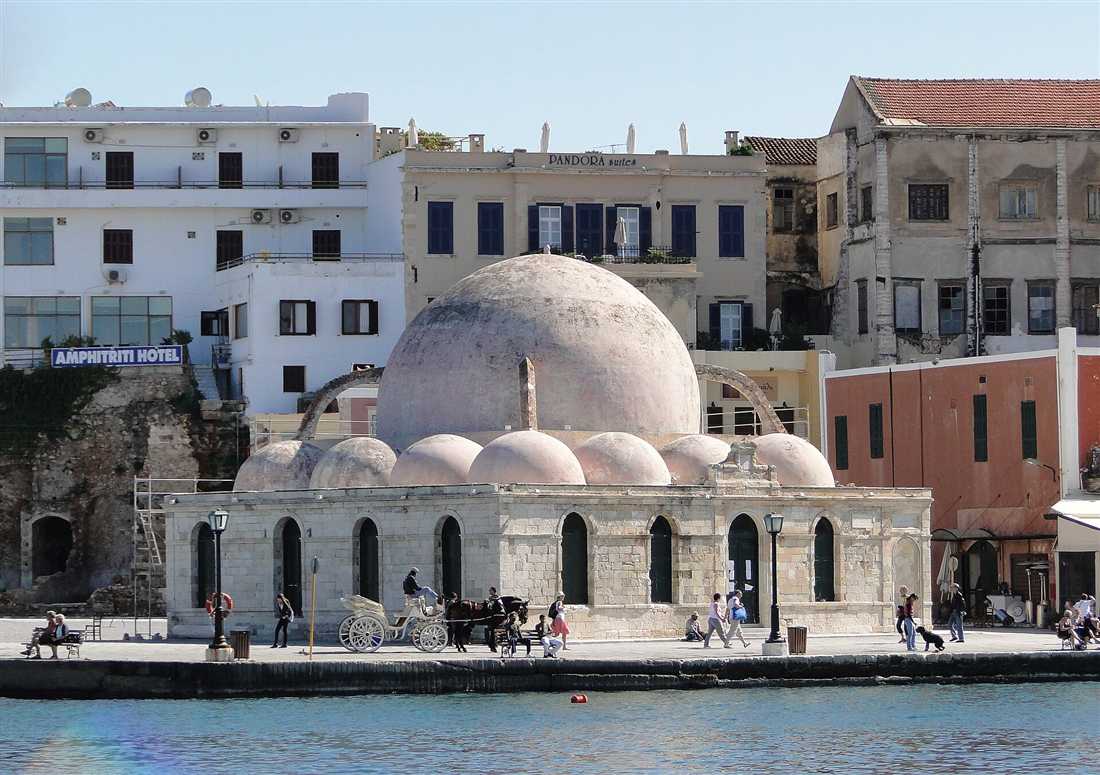
The Mosque of the Janissaries, also called the Kucuk Hasan Mosque, is the domed Ottoman mosque on the inner curve of the Venetian harbour, the oldest Ottoman building in Chania, a square hall crowned by a large hemispherical dome, now used as an exhibition and events hall.
The Ottomans built the mosque in the second half of the seventeenth century, immediately after they took Chania from Venice, and dedicated it to Kucuk Hasan, the first Ottoman commander of the town. It is the earliest Ottoman monument on Crete. The design is a pure cube of masonry roofed by a single wide dome that rests on four stone arches, with a cluster of smaller domes over the surrounding portico. The arcaded porch once ran along two sides of the building. Its minaret was demolished in the twentieth century, so the mosque now stands without a tower, its dome the dominant shape on the harbour front.
The building sits directly on the quay at the bend of the harbour, where the western and eastern arms of the promenade meet. Its pale dome against the water is one of the defining images of Chania, second only to the lighthouse. Inside, the single undivided hall is a broad open space beneath the dome, the walls stripped of their Ottoman furnishings and given over to art exhibitions, craft displays, and cultural events through the season.
The mosque marks the passage of Chania from Venetian to Ottoman rule as plainly as any building in the town. For four centuries the harbour front was Catholic and Venetian; the Kucuk Hasan Mosque planted the first Ottoman dome on that same quay and held the harbour as a Muslim monument for two and a half centuries. Its survival, minus the minaret, keeps both layers of the town’s history in a single view.
What is the Firka Fortress and the Maritime Museum?
The Firka Fortress is the Venetian bastion guarding the western entrance of the Chania harbour, a low square stronghold of thick stone walls that once closed the port with a chain across to the lighthouse; it now houses the Maritime Museum of Crete and is the site where the Cretan flag was first raised in union with Greece.
The Venetians built the Firka in the seventeenth century to command the harbour mouth and defend the western approach. Its name comes from the Turkish word for barracks, from the Ottoman garrison quartered there after the conquest. A heavy iron chain ran from the fortress across the harbour entrance to the base of the lighthouse, sealing the port against enemy ships at night. The fortress is a compact rectangle of ramparts and vaulted rooms around an open courtyard, its seaward walls pierced for cannon that swept the entrance and the open water beyond.
The Maritime Museum of Crete occupies the fortress rooms and traces the seafaring history of the island from the Bronze Age to the modern navy. Its galleries hold ship models, navigation instruments, maps, amphorae raised from wrecks, and a full section on the Battle of Crete and the German airborne invasion. A separate wing near the harbour holds a reconstructed Minoan ship, built by hand to ancient technique and rowed on open water as an experiment in Bronze Age navigation.
The Firka carries the deepest national meaning of any building on the harbour. It was here, at the fortress on the western point, that the flag of Greece was raised over Crete to mark the island’s union with the Greek state after centuries of Venetian and Ottoman rule. A ceremony each year still marks the raising at this spot. The fortress therefore closes the harbour twice over: as the physical guard of its western entrance, and as the place where Crete’s long passage under foreign rule ended.
What are the Neoria — the Venetian arsenals?
The Neoria are the Venetian arsenals of Chania, the long vaulted shipyard sheds built along the eastern arm of the harbour to build and repair galleys under cover, tall stone tunnels open to the water at one end; the Grand Arsenal at their head is the finest survivor.
The Venetians raised the Neoria across the sixteenth and early seventeenth centuries as the industrial heart of their naval base. Each arsenal is a single high vaulted hall, open at the seaward end so a galley slid straight from the water into the dry vault to be built, careened, and repaired through the winter. A row of these parallel sheds once lined the eastern shore of the harbour, their entrances facing the basin. Seven of the original arsenals survive along the waterfront, and two more stand apart to the east, stranded now behind the modern quay as the shoreline has shifted.
The Grand Arsenal, the Megalo Arsenali, stands at the eastern bend of the harbour where the promenade turns toward the arsenals. It is the largest and best restored of the vaults, a broad stone hall with a pitched roof, and it now serves the city as the Centre of Mediterranean Architecture, a venue for exhibitions, conferences, and cultural events. Its scale gives the clearest sense of what the whole row of arsenals once was: a covered dockyard sized to hold the galleys that carried Venice’s power across the eastern Mediterranean.
The Neoria are the least ornamented and most purely functional of the harbour monuments, and for that reason the most revealing. The lighthouse, the mosque, and the fortress each carry symbolic weight; the arsenals were pure engineering, the machine that built and maintained the fleet on which the whole fortified harbour depended. Walking their line along the eastern quay traces the working spine of the Venetian port.
What are the quarters of the old town — Topanas and Splantzia?
Topanas and Splantzia are the two principal quarters of the Chania old town: Topanas is the western, formerly Christian and Venetian district of grand stone houses rising above the harbour, and Splantzia is the eastern, formerly Muslim district of narrow lanes, a shaded square, and Ottoman and Byzantine building.
Topanas takes its name from the Venetian powder magazine that stood near the western walls. It climbs the slope above the harbour behind the Firka Fortress, a district of tall Venetian townhouses with carved stone doorways, coats of arms, and enclosed wooden balconies added under the Ottomans. Its narrow streets, Theotokopoulou chief among them, hold the densest concentration of restored Venetian architecture in the town, now given over to boutique hotels, craft shops, and small tavernas. The former Jewish quarter of Evraiki threads its lower lanes, where the restored Etz Hayyim synagogue stands as the last trace of the community.
Splantzia lies on the eastern side of the old town around the square of the Splantzia, a broad shaded space beneath a great plane tree, formally named for the heroes of the Cretan uprising against Ottoman rule. This was the Muslim quarter of the Ottoman town, and its texture is quieter and more residential than the harbour front. The Church of Saint Nicholas on the square carries both a Christian bell tower and an Ottoman minaret, a double sign of its passage from Catholic church to mosque and back to Orthodox church. The Byzantine church of San Rocco and a scatter of small chapels stand among the lanes.
The two quarters together map the divided history of Chania. Topanas held the Venetian and Christian establishment on the harbour heights; Splantzia held the Ottoman and Muslim population inland to the east. Kastelli on its low hill between them holds the oldest ground, the Minoan and Byzantine core where the town began. Walking from Topanas through Kastelli to Splantzia crosses the whole layered story of the old town in a few hundred metres.
What are the Venetian walls and moat of Chania?
The Venetian walls of Chania are the sixteenth-century ring of fortifications that enclosed the old town, a circuit of massive angled ramparts and pointed bastions fronted by a deep moat, of which the Sabbionara bastion to the east, the Schiavo bastion to the west, and long stretches of the land wall survive.
The Venetians replaced the older medieval defences with a modern bastioned trace across the sixteenth century, designed by their military engineers to withstand cannon. The walls form an angled circuit of thick, sloping ramparts studded with arrow-headed bastions at the corners, each bastion projecting so its guns raked the wall face between them. A wide dry moat ran outside the land walls to hold an attacker under fire before the ramparts. The system was built to resist the Ottoman siege that Venice knew was coming, and it held Chania as one of the strongest fortresses of the eastern Mediterranean.
The Sabbionara bastion guards the north-eastern corner where the walls meet the sea beyond the arsenals, its name meaning the sand gate, with a surviving Venetian gateway through the rampart. The Schiavo bastion, also called the San Salvatore bastion, anchors the south-western corner, and from its heights the land walls and the moat run in a clear line toward the sea. Between them the southern land wall survives as a long earth-backed rampart above the moat, the best-preserved stretch of the circuit and the clearest place to read how the defences worked.
The walls set the boundary of the old town to this day. Inside their line the streets keep their medieval knot; outside, the modern city of Chania spreads across open ground the moat once fronted. The seaward defences, the Firka on the west and the arsenals and Sabbionara on the east, tie the land walls back to the harbour, closing the fortified circuit that made Chania a single walled naval city from the sea to the hills.
What is the Chania covered market (Agora)?
The Agora is Chania’s cross-shaped municipal market hall, built in the shape of a Greek cross with four arms meeting under a central hall. It houses stalls selling Cretan cheese, herbs, honey, olives, raki and fresh produce.
The building opened at the start of the twentieth century and takes its plan from the covered market of Marseille. Its four arms stretch out at the edge of the old town, on the boundary between the Venetian quarter and the newer streets. Iron and glass form the roof, and daylight drops through the ridge onto the aisles below. The four entrances face the cardinal points, and each arm carries its own trade concentration, so the fishmongers, the butchers, the grocers and the tavernas each hold a defined stretch of the hall.
The produce arms stack barrels of Kalamata and green olives, wheels of graviera and myzithra cheese, jars of thyme honey from the White Mountains, and bunches of dried oregano, sage, mountain tea and dittany. Bottles of tsikoudia, the Cretan grape spirit also named raki, stand beside cold-pressed olive oil from the villages inland. Bakers sell paximadi, the twice-baked barley rusk that anchors the dakos salad, and small producers offer spoon sweets, carob syrup and Cretan wine.
Working tavernas sit inside the market arms and cook lunch for stallholders and shoppers, serving boiled greens, baked beans, grilled fish and the day’s stew. The fishmongers lay out the morning catch from the north coast on ice, and the butchers hang lamb, goat and pork raised in the mountain villages inland. Coffee roasters, spice merchants and dried-fruit stalls fill the connecting corners between the arms. The Agora functions as a live trading floor rather than a museum, so the ground stays wet from the fish counters and the air carries cheese, herbs and roasting coffee. For visitors staying in the old town, the market forms the practical larder of a self-catering trip and the single best place to taste the island’s raw materials before eating them cooked in a taverna.
What is the leather street (Stivanadika / Skrydlof Street)?
Stivanadika is the old town’s leather lane, named after the stivania, the traditional black Cretan boot. Skrydlof Street runs from the market end into the Venetian quarter, lined with workshops and shops selling handmade leather boots, sandals, belts and bags.
The word stivanadika joins stivani, the tall leather boot worn by Cretan men with the vraka trousers, and the suffix that marks a street of makers. Bootmakers cut, stitched and dyed the stivania here for generations, and a line of family workshops still stands along the street, with the leather smell of the tanning oils reaching the pavement. The craft passed from father to son, and the older masters still shape a boot on a wooden last by hand.
Today the street mixes the surviving bootmakers with a run of leather retailers. The shelves carry hand-cut sandals in the ancient Greek pattern, belts, satchels, wallets, jackets and the tall black stivania themselves, priced for both dancers who wear them at festivals and visitors who take a pair home. The sandal makers measure a foot and cut a strap to fit while the buyer waits, so a bespoke pair leaves the shop the same afternoon.
Skrydlof Street sits a short walk from the Agora, and the two form a natural shopping loop through the eastern edge of the old town. Walking it end to end takes a matter of minutes, yet the density of makers marks it as one of the last working craft streets in a Cretan town, where the product on the shelf started as hide in the same building. A pair of hand-stitched sandals from Stivanadika ranks among the most durable souvenirs the old town sells.
Where do you eat in Chania old town?
Chania old town splits into the harbour-front tavernas, set for the waterfront view, and the backstreet mezedopoleia of Splantzia and the inner lanes, where locals eat. The waterfront trades price and authenticity for the setting; the backstreets deliver Cretan cooking at village prices.
The Venetian harbour lines its quay with tavernas whose tables face the water and the lighthouse. The setting commands a premium, and the menus lean towards a broad tourist range rather than a tight Cretan list. A meal there buys the view of the harbour and the passing crowd, and the quality holds at the tavernas that cook to order rather than reheat.
The reward for walking inland is the mezedopoleio, the small-plate house where a jug of raki opens the meal and a run of mezedes covers the table. Splantzia, the quarter around the plane tree and the old mosque, holds a cluster of these rooms, along with courtyards shaded by vines. Cretan staples fill the menus: dakos with paximadi rusk, tomato and myzithra; boureki, the Chania courgette-and-potato bake with cheese and mint; apaki, smoked pork; gamopilafo, the wedding rice cooked in meat stock; snails in rosemary; and slow-cooked goat with stamnagathi greens.
The trade-off runs on a clear axis. Diners who prize the harbour view accept a wider, pricier menu; diners who prize Cretan cooking walk two streets back and eat where the raki is poured free and the boureki comes out of a home oven. Splantzia and the lanes off Chalidon and Daskalogianni carry the strongest concentration of the second kind, and a table booked away from the water at eight in the evening lands the local crowd rather than the passing one.
Where do you stay in Chania old town?
The old town’s boutique hotels occupy restored Venetian and Ottoman mansions, split between two quarters: Topanas on the west harbour, refined and quiet, and Splantzia to the east, atmospheric and more local. Both put the harbour within a short walk.
Topanas climbs the streets behind the west side of the harbour, the old Christian and consular quarter under the Firka fortress. Its stone mansions turned into small hotels carry vaulted ceilings, interior courtyards and roof terraces facing the lighthouse. The quarter stays quieter than the quay itself, and the walk down to the water runs a few minutes through Theotokopoulou Street with its craft shops.
Splantzia sits on the eastern side, the former Ottoman quarter around the Agios Nikolaos church, the minaret and the plane-tree square. Its guesthouses and boutique rooms sit among tavernas and cafés used by residents, and the mood tilts towards the everyday life of the town rather than the polish of the west. Prices tend to run below Topanas for a comparable room, and the noise of the evening tavernas reaches the closest windows.
The trade-off between the two quarters and the harbour edge itself turns on quiet against buzz. A room directly on the Venetian harbour trades sleep for the view and the passing crowd until late; Topanas buys calm and refinement at a higher rate; Splantzia buys atmosphere and value with taverna noise nearby. All three sit inside the pedestrian core, so a car parks on the perimeter and the luggage rolls in on foot. The mygreecetours.org Chania hub sets out the quarters and the routes between them in fuller detail.
What is there to shop for in the old town?
The old town’s strongest buys are handmade leather from Stivanadika, mountain herbs and raki from the Agora, hand-thrown Cretan ceramics, olive-wood kitchenware, woven textiles and local olive oil and honey. The craft streets of Topanas hold the ceramics and textiles.
Leather leads the list. The bootmakers and sandal shops of Skrydlof Street cut sandals to a foot on the spot, and the belts, bags and boots carry the mark of a working craft street rather than an import shelf. A hand-stitched pair outlasts the trip by years, which sets it apart from the mass-produced souvenir.
The edible souvenirs concentrate in the Agora and the grocers off it: thyme honey, cold-pressed olive oil, thyme, oregano, sage, mountain tea and dittany, bottled raki and Cretan wine, carob syrup and spoon sweets. These pack flat, clear customs as food, and carry the island’s flavours home. Theotokopoulou Street in Topanas runs a line of artisan studios where potters sell hand-thrown bowls and plates glazed in Cretan blues and earth tones, and weavers offer runners, throws and bags on the loom pattern.
Olive wood turns into boards, spoons, bowls and mortars in the same craft cluster, and small jewellers work silver in Minoan and Byzantine motifs. Booksellers stock Cretan histories and recipe books in translation, and soap makers press bars from local olive oil scented with the same mountain herbs the Agora sells by the bunch. The shopping map draws a loop: the Agora and Stivanadika at the east for food and leather, Theotokopoulou and the Topanas lanes at the west for ceramics, textiles and wood. Buyers who want the maker rather than the middleman stay off the main Chalidon tourist run and walk the side streets, where the studio and the shelf share a doorway.
How do you spend an evening in Chania old town?
An evening runs from the sunset walk out along the harbour breakwater to the Venetian lighthouse, into a taverna dinner in Splantzia or on the quay, and then into the bars and lanes off the harbour, where cocktail rooms and music bars stay open past midnight.
The evening opens on the mole. The stone pier curves out from the harbour to the restored lighthouse, and the walk along it turns the whole Venetian front and the White Mountains behind into the sunset backdrop. The light drops behind the Firka fortress on the west side, and the harbour water holds the colour after the sun clears the horizon. The full circuit of the breakwater and back takes around half an hour at a stroll.
Dinner follows the eating map: the quay for the water view, Splantzia and the inner lanes for the local table and the raki. After the plates clear, the town’s nightlife concentrates in the lanes behind the harbour and along Sarpaki and Sifaka, where cocktail bars, wine rooms and music bars fill the ground floors of the old houses. The crowd tilts young and the noise builds after eleven.
The pace stays walkable throughout. The lighthouse pier, the tavernas and the bars all sit inside the pedestrian core, so an evening moves entirely on foot from the west harbour to Splantzia without a taxi. Families and couples who want the calm version stop at the harbour stroll and an early dinner; the late crowd carries on into the bar lanes. Either way the Venetian architecture and the floodlit harbour hold the setting through the night.
How do you get to Chania old town and where do you park?
Chania International Airport on Akrotiri lies fourteen kilometres east of the old town, a twenty-minute drive; the ferry port at Souda sits seven kilometres east. The old town core is pedestrian, so cars stop at the perimeter car parks and the harbour is reached on foot.
Flights land at Chania airport (IATA code CHQ) on the Akrotiri peninsula. Airport buses and taxis run to the town centre, and the drive takes around twenty minutes on the national road. Ferries from Piraeus dock overnight at Souda Bay, and a bus or taxi covers the seven kilometres into town in a quarter of an hour. The intercity KTEL bus station sits at the southern edge of the old town, a short walk from the harbour.
Inside the old town, cars stay out. The Venetian streets are narrow, cobbled and closed to through traffic, so the harbour, Topanas and Splantzia are all reached on foot. Drivers leave the vehicle on the perimeter: the pay car parks around the market and along the seafront to the east take day and overnight stays, and the streets outside the historic core carry metered and blue-zone bays. The walk from the perimeter car parks to the harbour runs a few minutes.
The practical routine for a driving visitor parks once on the edge and walks the whole old town from there. Hotels inside the pedestrian zone arrange a drop-off for luggage and direct guests to the nearest car park, since no hotel door inside the core takes a car. For day-trippers arriving by hire car, the eastern seafront car parks near the Agora put the market and Stivanadika within the first two minutes of the walk in.
When is the best time to visit Chania old town?
Spring, from April to early June, and autumn, from September to October, deliver warm days, open sea and thin crowds. High summer brings heat and packed lanes, so July and August visits work best in the early morning and the evening, avoiding the midday harbour crush.
The shoulder seasons pair the strongest conditions. April and May bring wildflowers on the hills, sea temperatures climbing towards swimming, and a town that breathes between the winter quiet and the summer peak. September and October hold the warm sea from the long summer while the crowds thin and the raki flows at a calmer pace. Room rates in both windows run below the July and August peak.
High summer trades that calm for heat and density. Midday sun on the harbour pushes temperatures past thirty degrees, and the quay fills with cruise passengers and package crowds between eleven and four. Visitors in July and August walk the old town at first light, when the market opens and the lanes stand empty, and again after six, when the harbour cools and the evening pace takes over. The dead middle of the day suits a beach or an indoor museum rather than the exposed quay.
Winter, from November to March, empties the town of visitors, closes a share of the seasonal tavernas and hotels, and brings rain off the White Mountains, yet leaves the Venetian architecture and the working Cretan life on full show for anyone who wants the town without the trade. The clearest all-round windows stay the two shoulder seasons, when the sea, the weather, the prices and the crowds line up in the visitor’s favour.
What day trips start from Chania old town?
Chania old town anchors day trips to Balos lagoon and Gramvousa island on the north-west tip, the pink-sand beach of Elafonisi in the south-west, the Samaria Gorge on the White Mountains crossing, and the Akrotiri peninsula with its monasteries and the tomb of Eleftherios Venizelos.
Balos lagoon and the islet of Imeri Gramvousa sit at the north-western corner of Crete. Boats run from Kissamos port west of Chania to the Venetian sea fortress on Gramvousa and the turquoise shallows of the lagoon, and a road-and-track route reaches Balos overland to a cliff-top descent. The mygreecetours.org guide to Balos lagoon sets out the boat and the road approaches in full.
Elafonisi lies at the south-west end, a shallow lagoon where crushed shell tints the sand pink and a wade crosses to the islet. The drive from Chania runs through the mountain villages and takes around ninety minutes each way. The Samaria Gorge cuts through the White Mountains from the Omalos plateau down to the Libyan Sea at Agia Roumeli, a sixteen-kilometre walk that ends with a ferry along the south coast. The mygreecetours.org page on the Samaria Gorge covers the bus, the descent and the boat out.
Closer to base, the Akrotiri peninsula east of the town holds the monasteries of Agia Triada and Gouverneto, the war cemetery, and the hilltop tomb of the statesman Eleftherios Venizelos above the town, a fifteen-minute drive with a view back over the harbour and the bay below. The peninsula also holds Stavros beach, the sheltered cove used as a film location for the finale of Zorba the Greek, within the same short circuit. The mix runs from a half-day on Akrotiri to a full day at Balos, Elafonisi or Samaria, and the old town’s central bus station and the harbour boat agents book the lot within a short walk of the hotels.
Frequently Asked Questions
What is there to see in Chania old town?
Chania old town centres on the Venetian harbour with its Egyptian lighthouse, the domed Mosque of the Janissaries, the Firka Fortress and Maritime Museum, the Neoria arsenals, and the alleys of the Topanas and Splantzia quarters behind the waterfront.
Is Chania old town worth visiting?
Chania old town ranks among the most beautiful in Greece, a lived-in maze of Venetian mansions, Ottoman minarets and harbour tavernas. The lighthouse walk, the covered market and the backstreet workshops reward a full day and an evening.
How do you get to Chania old town and where do you park?
Chania old town sits by the harbour, 15 kilometres from the airport and 7 from the port. The core is pedestrian, so drivers park on the perimeter at the Talos or harbour car parks and walk in.
What is the best photo spot in Chania old town?
The pier out to the Egyptian lighthouse gives the classic view back over the harbour, the domed Mosque of the Janissaries and the pastel Venetian waterfront, best at golden hour when the stone glows and the water stills for a mirror reflection of the port.