
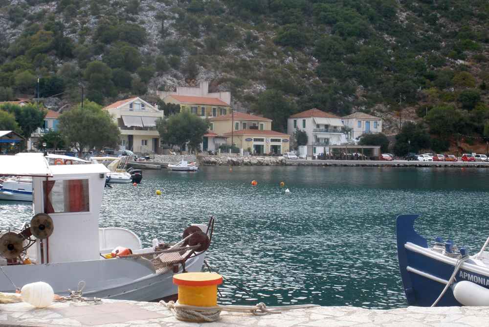
Poros occupies a narrow coastal shelf on the southeast side of Kefalonia, the largest of the Ionian Islands. The town lies about 40 km by road from Argostoli, the island capital, and about 12 km north of Skala. Ferries cross from Poros to Kyllini in the northwest Peloponnese, which makes the town a working entry point to Kefalonia rather than a resort built around one beach. A pebble-and-sand shore runs along the front, steep hills rise directly behind the houses, and the harbour handles vehicles and foot passengers at one end of the bay. Plan the whole trip with Greece Tours.
Three features give Poros its shape: the ferry quay, the seafront strip of tavernas and rooms, and the gorge that cuts inland through limestone walls behind the town. Above the settlement, the Monastery of Panagia Atrou stands on a high ridge, one of the oldest religious sites on Kefalonia. Excavations near the town uncovered a Mycenaean chamber tomb and the Drakena cave, evidence that this stretch of Kefalonian coast carried traffic long before the ferry ramp arrived. The southeast coast stays quieter than the northwest, and Poros reads as a port town first.
What is Poros in Kefalonia and where does it sit on the island?
Poros is a small port town on the southeast coast of Kefalonia, about 40 km by road from Argostoli. The settlement runs along a pebble-and-sand shore below steep hills, with a working ferry harbour at one end.
Poros belongs to Kefalonia, the largest of the Ionian Islands, and sits on its southeast coast facing the Peloponnese across a narrow strait. The town occupies a flat strip between the sea and steep limestone slopes, so the built area stays long and shallow rather than spreading inland. Houses, rooms and tavernas line the shore road, while the ferry quay closes the northern end of the bay. The scale stays small, and a walk from one end of the Poros seafront to the other takes about fifteen minutes at an easy pace.
Distance sets the character of Poros. Argostoli lies about 40 km away by road across the mountainous middle of Kefalonia, a drive of about an hour on winding tarmac. Skala sits about 12 km south along the coast road, and Sami about 25 km north. Kefalonia Airport, south of Argostoli, sits roughly 45 km away. Poros therefore serves the southeast of the island as a local hub, with a bakery, a supermarket, a pharmacy and a fuel station. The town works less well as a base for touring all of Kefalonia in short hops.
The name Poros means passage or ford in Greek, and the geography of this Kefalonian coast explains it. Water cut a cleft through the limestone ridge behind the shore, and that cleft carries the inland road today. The town grew where the passage meets the sea, at the point where boats found shelter and traffic found a route into the interior. The southeast coast of Kefalonia has few natural harbours of this kind, so the position mattered long before ferries. The modern ferry quay formalises what the terrain already favoured, and the road inland still uses that same cleft.
Poros differs from the Kefalonian villages photographed most often. Fiskardo and Assos in the north trade on Venetian houses and pastel facades. Poros carries plain low buildings, most raised again after the Ionian earthquake that levelled the island. The result is a functional seafront rather than a preserved one. Travellers who arrive expecting a picture-book harbour find a working Kefalonian port instead. With fishing boats, a ferry ramp, parked cars and a beach that starts three metres from the road. The plainness is the point, because Poros earns its living from the crossing rather than from postcards.
How does the ferry from Kyllini reach Poros in Kefalonia?
Ferries cross from Kyllini, on the northwest coast of the Peloponnese, to Poros in about ninety minutes.
The Kyllini crossing is the reason most travellers meet Poros at all. Kyllini sits on the northwest coast of the Peloponnese, reachable by road from Patras and from Athens, and the sea route saves a long detour to the other Kefalonian ports. Sailings run more often in summer than in winter, and vehicle space fills before passenger space in August. Schedules shift through the year, so checking departures before travelling matters; the practical options across the island are set out in how to get to Kefalonia for every arrival route.
Arrival at Poros is direct. The ramp drops onto a quay at the edge of town, and the exit road joins the Kefalonian coast road within about 200 metres. Cars queue briefly, then turn either south towards Skala or northwest up the gorge road inland. Foot passengers step off into the town itself, with tavernas, a bakery and rooms within 300 metres. No shuttle system separates port from settlement, because the two occupy the same short strip of shore below the hills. Drivers who want coffee before the mountain road park within 100 metres of the ramp.
Departing from Poros follows the same compact pattern. Vehicles form a line on the quay road, tickets are handled at small offices on the seafront, and boarding starts shortly before sailing. Drivers leaving the south of Kefalonia often prefer this crossing to the longer route from Sami, about 25 km north. The drive to Poros is shorter, and the sea leg lands closer to the Peloponnese road network. Foot passengers connect onward from Kyllini by bus towards Patras and Athens. Arriving at the quay thirty minutes before departure covers car loading in high season.
Weather shapes the crossing more than distance does. The strait between Kefalonia and the Peloponnese opens to the south, and strong southerly winds disrupt sailings from either end. Cancellations concentrate in winter and early spring, when frontal systems cross the Ionian Sea. Travellers with a flight to catch build in a buffer day. In settled summer conditions the water stays flat for most of the passage, and the mountains of Kefalonia stay visible from the deck for the whole crossing. The peak of Mount Ainos marks the skyline long before the Poros harbour comes into focus.
What is the seafront and beach of Poros in Kefalonia like?
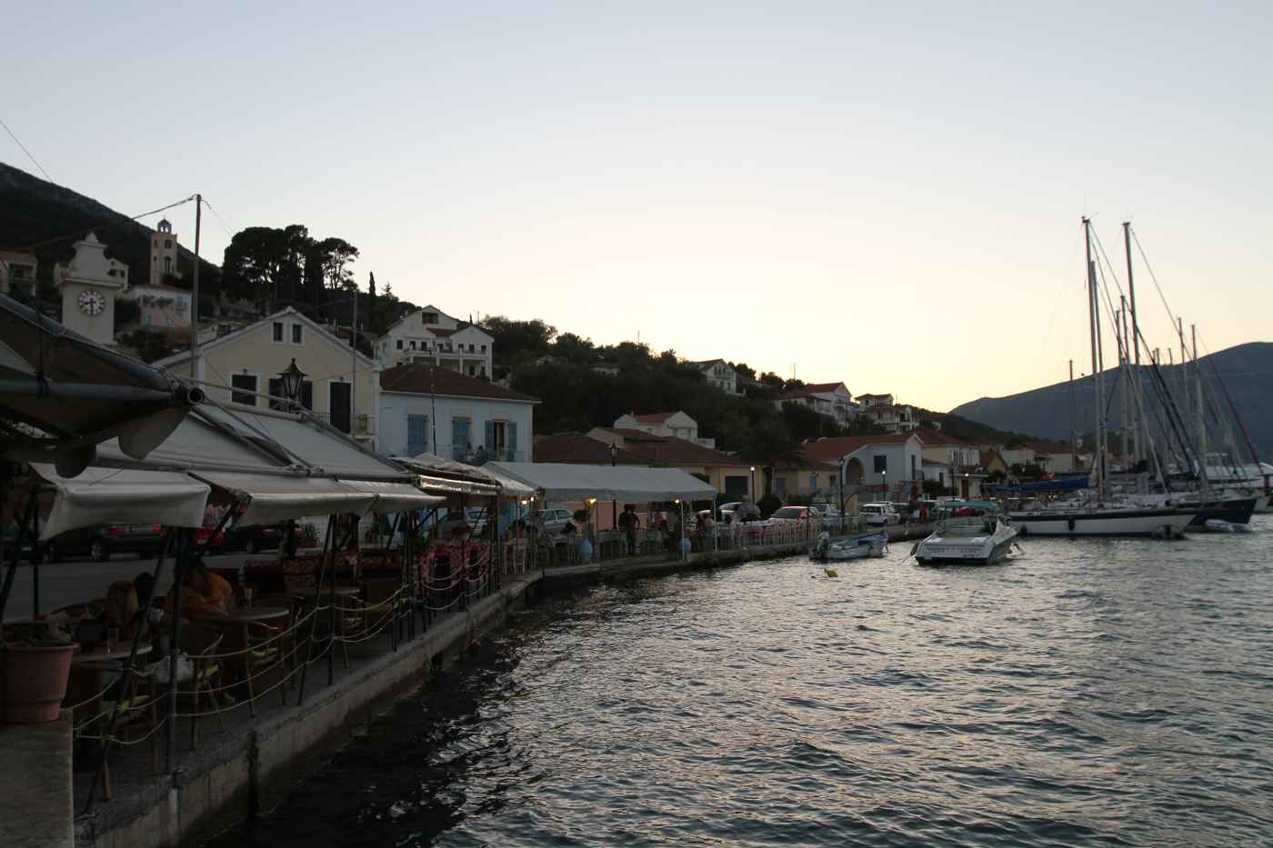
The Poros seafront runs about 700 metres along a pebble-and-sand shore, lined with tavernas, rooms and cafes facing the water. The beach starts three metres from the road, and the working harbour closes its northern end.
The shore at Poros mixes grey pebbles with coarse sand, and the mix changes along the bay. The southern stretch, below the hills, holds more sand and shallower water, while the northern part turns stonier as it nears the harbour. Water depth increases within three metres of the waterline, so this Kefalonian beach suits swimmers more than small children. A line of tamarisk trees gives natural shade along parts of the strip, and umbrellas cover the central section through the summer. Pebbles stay smooth and rounded, so water shoes help only on the northern stretch.
The seafront road carries the daily life of the town. Tavernas set tables on the sea side, fishing boats tie up at the far end, and small shops sell groceries, ferry tickets and beach goods. Evening traffic stays light, because through-traffic uses the gorge road behind the houses. Prices on this coast run below those of the northern Kefalonian villages, and menus lean on fish landed locally and on island dishes such as kreatopita, the Kefalonian meat pie. Robola wine from the high Omala valley appears on most lists, poured by the half-litre carafe.
Poros stays quieter than the resorts further south on the same coast. Skala, about 12 km down the road, holds a long sand beach, more hotels and a busier strip of bars, while Poros keeps a smaller bed base and a slower rhythm. Families who want organised watersports drive south for the day and return in the evening. The trade-off works in both directions, since Poros gives easy parking and short queues. The 20-minute drive between the two towns makes the pairing practical for a week on the Kefalonian southeast coast.
Swimming conditions along the Poros shore depend on wind direction. Southerly winds push swell straight into the bay and stir the pebbles, while northerly winds leave the water calm and clear. The bay faces roughly southeast, so morning sun reaches the water early and the hills behind cast shade over the beach in late afternoon. Small coves north of the harbour, reached on foot in about ten minutes along the shoreline, hold clearer water on days when the main Poros beach is churned up. Local swimmers read the forecast by wind direction rather than by temperature.
What is the Poros gorge behind the town in Kefalonia?
The Poros gorge is a narrow limestone cleft directly behind the town, cut by water through a coastal ridge. The main road inland runs along its floor for roughly two kilometres, between rock walls that rise steeply on both sides.
The gorge opens immediately behind the houses of Poros, and drivers enter it within a minute of leaving the seafront. Rock walls close to within three metres of the tarmac in the narrowest section, and the sky reduces to a strip overhead. Water carved the passage through soft limestone over geological time, leaving vertical faces streaked with mineral staining. The road follows the old route inland, which existed as a mule path long before vehicles reached this part of Kefalonia. Passing places are limited, so buses and trucks take the middle of the lane.
Walking the gorge shows what a car passes in three minutes. Ferns and fig trees root in the wall cracks, and cool air pools on the floor even in August, when the Kefalonian coast runs hot. Rockfall netting covers stretches of the upper face, a reminder that the limestone still moves. The gradient stays gentle for most of the length, then climbs where the cleft opens into the valley behind. The walk from the Poros seafront to the upper end and back takes about an hour on foot, with traffic passing close.
The gorge also explains the isolation of the town. Poros sits behind a mountain barrier, and this cleft is the only easy line through it from the port. Before the road was widened, traffic towards Argostoli followed the same passage in single file, and the settlement stayed small. Freight for the southeast of Kefalonia still moves through the gap. Anyone driving from the ferry to the west coast crosses it, then climbs into the interior towards the Omala valley and the monastery of Agios Gerasimos. The gorge therefore doubles as the gate of the whole southeast.
Photographs of the Poros gorge rarely capture its scale, because the walls sit too close together for a wide frame. The clearest sense of depth comes from standing at the seaward entrance and looking up at the ridge line, roughly 80 metres above the road. Winter rain sends water down the faces, and small falls appear on the north side after storms. Drivers keep headlights on inside the cutting, since the shade is deep and oncoming vehicles emerge from the bends with little warning. Cyclists climbing towards the interior use the early morning, before the ferry traffic starts.
What is the Monastery of Panagia Atrou above Poros?
Panagia Atrou is a monastery on the ridge above Poros, counted among the oldest religious sites on Kefalonia. A steep road climbs to it from the coast, and the terrace commands a wide view over the southeast shoreline.
Panagia Atrou stands on the hill of Atros, the high ground west of Poros, at roughly 500 metres above the sea. Tradition places its foundation in the Byzantine centuries, which ranks it among the oldest monastic sites on Kefalonia. Earthquakes damaged the buildings repeatedly, and the present complex combines older stonework with later rebuilding. A church, a walled courtyard and monastic cells make up the site on its exposed ridge. The feast of the Virgin in mid-August draws worshippers from Poros and from the surrounding villages of the Kefalonian southeast, who drive the ridge road in convoy.
The approach road turns inland from the Kefalonian coast road near Poros and climbs in tight switchbacks. The drive covers about 5 km and gains most of its height in the final stretch, on a surface that narrows towards the top. Cars park below the gate, and the last short section is walked. Drivers of camper vans and coaches leave them in Poros, because turning space is limited. The climb takes about twenty minutes by car from the Poros seafront, and longer behind slow traffic. Rain leaves gravel on the bends, so the descent asks for low gear.
The view is the reason for the climb. From the terrace the whole southeast coast of Kefalonia opens up, with Poros directly below, the mountains of the Peloponnese across the strait, and the coastline running south towards Skala. Ferries crossing to Kyllini stay in sight for a long stretch of their route. Clear winter days give the sharpest visibility, while summer haze softens the far shore. Mount Ainos, at about 1,628 metres the highest peak in the Ionian Islands, rises to the northwest behind the ridge. Sunrise over the Peloponnese is the sharpest hour for photographs from the terrace.
Visiting Panagia Atrou follows normal Greek monastery practice. Shoulders and knees stay covered, voices stay low inside the church, and the gate closes during the early-afternoon rest. Entry is free, and a candle stand with a small icon counter sits inside the courtyard. The monastery keeps limited hours outside summer, so travellers arriving in winter ask in Poros before driving up the ridge. Photography inside the church is restricted, while the terrace and the view across the strait stay open to everyone who arrives. Water and shade are scarce at the top, so visitors carry a bottle up from Poros.
What ancient sites lie near Poros on the southeast coast of Kefalonia?
Archaeologists have excavated a Mycenaean chamber tomb and the Drakena cave close to Poros. Both finds place this corner of Kefalonia inside long-running networks of settlement and trade, well before the classical and Roman periods.
The Mycenaean chamber tomb near Poros follows the burial tradition of the late Bronze Age Aegean, with a cut passage leading into a rock-carved chamber. Similar tombs across Kefalonia at Mazarakata, Lakkithra and Metaxata form one of the densest Mycenaean cemetery groups in the Ionian Islands. The concentration shows an island populated and organised during the Mycenaean centuries, not a margin of the Greek world. Grave goods from these chambers sit in the archaeological collection in Argostoli, about 40 km from Poros. Bronze weapons, beads and painted pottery make up the bulk of that material.
The Drakena cave sits above the gorge on the slope near Poros, and excavation there reached layers from the Upper Palaeolithic and the Neolithic. The finds include stone tools, hearth traces and pottery from later phases, which makes the cave one of the earliest documented occupation sites on Kefalonia. Ritual use of the cave continued into historical antiquity. The site lies on rough ground and is not developed for casual visits, so the material reads more clearly in museum displays than at the cave mouth itself. The cave nonetheless anchors the deep prehistory of this Kefalonian coast.
The pattern of finds around Poros follows the passage through the ridge. The cleft gave access from a sheltered Kefalonian shore to the interior, and settlement clustered where those two advantages met. The long argument over which Ionian island was the Ithaca of Homer draws in sites of this kind, and southeast Kefalonia enters the debate through them. The evidence stays fragmentary. What holds firm is continuous human presence on this coast from the Palaeolithic through the Mycenaean centuries and into Roman times. Every phase used the same passage between the shore at Poros and the fertile ground inland.
Roman-period remains continue the sequence a short drive away. Skala preserves the mosaic floors of a Roman villa under a protective shelter, with panels showing sacrifice scenes and geometric borders. That site lies about 12 km south of Poros and opens to visitors for a small fee. Pairing the villa at Skala with the Mycenaean material from the Poros area gives the southeast coast of Kefalonia a readable timeline. From Bronze Age burials to Roman country houses, inside fifteen kilometres of shoreline. Both stops fit into one morning by car, with time left for a swim at Poros.
Where do travellers stay in Poros, and how do they reach it from Argostoli and Skala?
Poros offers rooms, self-catering apartments and small family hotels along the seafront and the slope behind it. The Kefalonian road network links the town with Argostoli, about 40 km northwest, and with Skala, about 12 km south.
Accommodation in Poros concentrates on the seafront and on the terraces climbing behind it. Rooms and self-catering apartments outnumber hotels, and most buildings hold fewer than twenty units. Rates sit below those of the northern Kefalonian villages and below Skala through the summer. Sea-facing rooms at the harbour end catch ferry noise early in the morning, while the southern end of the beach stays quieter. A comparison of bases across the island, coast by coast, appears in where to stay in Kefalonia for travellers weighing the Poros option against the north.
The road from Argostoli to Poros runs about 40 km and takes around an hour. The route climbs across the spine of Kefalonia, passes the turn-off for the Omala valley, and drops through the gorge into the town. Public buses link the two on a limited schedule, with more services in summer than in winter. Drivers coming from Sami take the east-coast road, about 25 km, on a slower alignment above the sea. Fuel is available in Poros and in Skala, and less reliably in the mountain villages between. Taxis cover the Argostoli run for travellers without a car.
Poros works as a base for the southeast of Kefalonia rather than for the whole island. Day trips reach the beach and Roman mosaics at Skala in 20 minutes. Antisamos beach and the Melissani cave near Sami take about 45 minutes, and Myrtos beach about ninety minutes each way. Travellers who plan to spend most of their time at Assos, Fiskardo or Lixouri pick a base further north instead, because the driving times from Poros run long on mountain roads. A rental car remains the practical way to use the town as a base.
The southeast coast keeps a different rhythm from the north of Kefalonia. Villages between Poros and Skala, among them Tzanata, Markopoulo and Katelios, sit among olive groves and vineyards, with tavernas that open mainly for dinner. Markopoulo draws attention each August for the harmless snakes that appear around its church at the feast of the Virgin. Nights stay dark and quiet, the beaches empty by early evening, and the last ferry leaving Poros marks the end of the day’s movement. Travellers who want nightlife drive to Skala, then return along the dark coast road to sleep.
Frequently Asked Questions
Where exactly is Poros on Kefalonia?
Poros sits on the southeast coast of Kefalonia, facing the Peloponnese across a narrow strait, about 40 km by road from Argostoli and about 12 km north of Skala. The town occupies a flat shelf between the sea and a steep limestone ridge. With a pebble-and-sand beach along its front and a ferry quay at the northern end of the bay. Behind the houses a gorge cuts through the ridge and carries the inland road towards the centre of the island. The position gives Poros two roles at once: a landing point for vehicles crossing from Kyllini, and a small resident town serving the villages of the Kefalonian southeast.
Driving time from Kefalonia Airport runs about an hour and ten minutes on mountain roads.
How long does the ferry crossing from Kyllini to Poros take?
The crossing between Kyllini and Poros takes about ninety minutes on a vehicle ferry, covering the strait between the northwest Peloponnese and southeast Kefalonia. Sailing frequency rises in summer and drops sharply in winter, so confirming the day’s departures before driving to either port matters. Vehicle space fills earlier than passenger space during August. Boarding at Poros happens on a ramp at the north end of the bay, about 200 metres from the tavernas, which keeps the transfer short at the Kefalonian end. Strong southerly winds disrupt the route, and cancellations cluster in winter and early spring.
Travellers with an onward flight from Kefalonia Airport or from the mainland build in a spare day rather than depending on one sailing.
Is Poros a practical base for exploring Kefalonia?
Poros works well as a base for the southeast of Kefalonia and less well for the island as a whole. Skala and its Roman villa mosaics sit 20 minutes south, Katelios and the inland villages lie within half an hour. Sami. Antisamos beach and the Melissani cave fall about 45 minutes north. Argostoli takes about an hour by road across the mountains. The northwest coast is the weak point, because Myrtos beach. Assos and Fiskardo each demand roughly ninety minutes to two hours in each direction, which turns a beach afternoon into a full driving day.
Travellers who intend to concentrate on northern Kefalonia choose Argostoli, Sami or Fiskardo instead, and keep Poros for the night before an early ferry to Kyllini.
Can visitors reach the Monastery of Panagia Atrou without a car?
Reaching Panagia Atrou without a car means walking, since no bus service runs up the monastery road from Poros. The route climbs about 5 km from the Kefalonian coast to a ridge at roughly 500 metres. With the steepest gradient in the final section. Takes around two hours on foot in each direction. Walkers start early, carry water and wear proper shoes, because shade is scarce and the surface turns loose in places. Taxis from Poros make the trip and wait at the top, which suits visitors short on time. Drivers of camper vans leave them in town, as turning space by the gate is limited.
The terrace repays the effort with a view over Poros, the strait and the Peloponnese coast opposite.
What is the beach at Poros like?
The beach at Poros runs about 700 metres along the front of the town and mixes grey pebbles with coarse sand. Sandier at its southern end and stonier towards the harbour. Water deepens within three metres of the shoreline, which suits confident swimmers more than toddlers. Tamarisk trees give natural shade along parts of the strip, and umbrellas cover a central section in summer. Tavernas and rooms face the water directly, so the walk from a sunbed to lunch takes under a minute. Southerly winds push swell into the bay and cloud the water, while northerly winds leave it flat and clear.
Families wanting a long sand beach with organised watersports drive 12 km south to Skala for the day.
What is there to see around Poros beyond the beach?
The gorge behind Poros, the Monastery of Panagia Atrou above it and the ancient sites nearby fill a full day without leaving the southeast of Kefalonia. The gorge starts a minute from the seafront and takes about an hour to walk there and back between limestone walls. Panagia Atrou sits on the ridge at roughly 500 metres and ranks among the oldest religious foundations on the island. Excavation near the town uncovered a Mycenaean chamber tomb and the Drakena cave, occupied from the Upper Palaeolithic onwards. Skala, 12 km south, adds Roman villa mosaics under a shelter.
The inland villages of Tzanata and Markopoulo, both within 10 km of Poros, sit among olive groves and open mainly in the evening for dinner.