
Trikala tours start in the capital of the Trikala regional unit in western Thessaly, a town split by the Lithaios river and watched over by a Byzantine fortress with a clock tower. The routes cover the Varousi quarter, the Koursoum Mosque, the Matsopoulos Mill and the rocks of Meteora to the north-west. Greece Tours lists the day trips that pair the town with the monasteries.
This page covers what Trikala tours see in the town, which day trips run to Meteora, the Theopetra Cave and the Pindos villages, how visitors reach Trikala, and which season suits each route. The tours below are checked on GetYourGuide and leave from Trikala, Kalambaka, Volos and Athens.
What do Trikala tours cover?
Trikala tours cover the capital of the Trikala regional unit in western Thessaly, a city of 62,064 people at the 2021 census. The Lithaios river crosses the centre, and the walks link a Byzantine fortress, an Ottoman mosque, an old quarter and an industrial mill.
Trikala is the seat of the Municipality of Trikkaioi. The Lithaios, a tributary of the Pineios, splits the city in two. Meteora lies close by, but Trikala tours keep the focus on the town itself.
The city passed to Greece on 23 August 1881 under the Treaty of Constantinople. Planners then laid out a Hippodamian grid with Neoclassical buildings across the centre.
- Municipality: 78,605 residents in 2021 and 607.585 square kilometres, formed in 2011 from 8 former municipalities.
- Smart city: Trikala was the first smart city in Greece and offers e-governance services.
- Driverless buses: Trikala was the first city in the world to run CityMobil2 driverless buses in a European Union programme.
Trikala tours also combine with Karditsa tours for a wider look at Thessaly.
What do Trikala tours see in the old quarter of Varousi?
Trikala tours walk through Varousi, the Christian quarter of Ottoman times at the foot of the fortress. The whole district is now listed for protection. Its houses date from the 17th to the 19th century, and ten churches stand close to each other.
Varousi was the noble district of Trikala until the 1930s. It ran along the eastern side of the fortress and governed its own affairs under Ottoman rule. Its mansions show elaborate styles and long eaves, a sign of the trade and crafts that grew in the 18th and 19th centuries.
Vasilis Tsitsanis, the songwriter from Trikala, made the lanes known as “Dyo Stena” and “Stena tou Sakaflia”. The Old Manavika district continues down to the central square, with tavernas and café-bars. Trikala tours also reach Koutsomylia, a district of the same style on the north side of Prophet Elias hill.
- Agioi Anargyroi: a church with wall paintings dated 1575.
- Agios Dimitrios: a church built before 1588.
- Agia Marina: a church from 1766.
- Agios Stefanos: the present church dates from 1882, while the first church on the site went up under Symeon Uroš Palaiologos in the 14th century.
What do Trikala tours show at the Trikala Fortress and its clock tower?
Trikala tours climb to the fortress that Emperor Justinian I built in the 6th century on the acropolis of ancient Trikke. The Ottomans repaired it and set a clock tower on its eastern side in the mid-17th century. The present clock dates from 1936.
The castle crowns a low hill on the northeast side of the city. It follows a typical Byzantine plan, long in shape and reinforced with square towers. Cross walls split it into a lower, a middle and an inner fortress. The walls were repaired again after the Thessalian revolts of 1854 and 1878.
The first Ottoman clock had a bell of about 650 kilograms, in a stone tower about 15 metres tall. Mayor Theodosios Theodosopoulos built the new clock with money from the bequest of Athanasios Mikros. Today the fortress hosts the open-air theatre of the municipality, and Trikala tours use the clock tower for a view over the whole city.
- Its Kale: the inner fortress on the northeast corner, guarded by four large and tall towers.
- Tunnel: a tunnel starts from the bottom of a well on the third level and crossed Prophet Elias hill.
- New bell: a notice from the mayor set the bell of the new clock at 400 okades, or 516 kilograms.
Trikala tours learn that the municipality ranks this clock tower, together with the one in Larissa, among the oldest known in Ottoman-ruled Greece.
Which Ottoman monuments do Trikala tours visit?
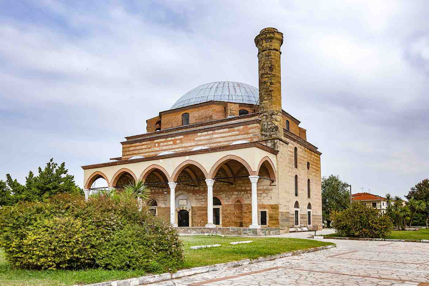
Trikala tours visit the Osman Shah Mosque, also called the Koursoum Mosque, a 16th-century work by the architect Mimar Sinan. It is the only Sinan mosque in modern Greece. Near it stands the twin Ottoman bath known as the Hammam of Osman Shah.
The name Koursoum comes from the Turkish word kurşun, meaning lead, because lead covers the dome. Osman Shah, a grandson of Sultan Selim I, governed the Sanjak of Trikala and founded the mosque. Local tradition holds that he built it after he recovered from an illness in Trikala. He died in 1567/8 and lies in an octagonal tomb beside the mosque.
A square prayer hall sits under a dome 18 metres in diameter, and the ashlar minaret stands at the northwest corner. Trikala tours see a building that today serves as an events space.
- Last mosque standing: the only one left in Trikala out of at least eight mosques that Evliya Çelebi recorded.
- Hammam of Osman Shah: a 16th-century twin bath beside the Lithaios, attributed to Sinan, which held the city prison from 1893 to 2006.
- Tsitsanis Museum: opened in March 2017 on the upper floor of the hammam and records the life and work of Vasilis Tsitsanis.
- Courthouse: a stone building of Ottoman times that housed the Turkish administration and has held the city courts since 1915.
What do Trikala tours see along the Lithaios river and at the Matsopoulos Mill?
Trikala tours follow the Lithaios river through the city centre, cross the metal Central Bridge that French engineers built and stop at the Matsopoulos Mill of 1884. Each Christmas season the mill turns into the Mill of Elves, the largest Christmas theme park in Greece.
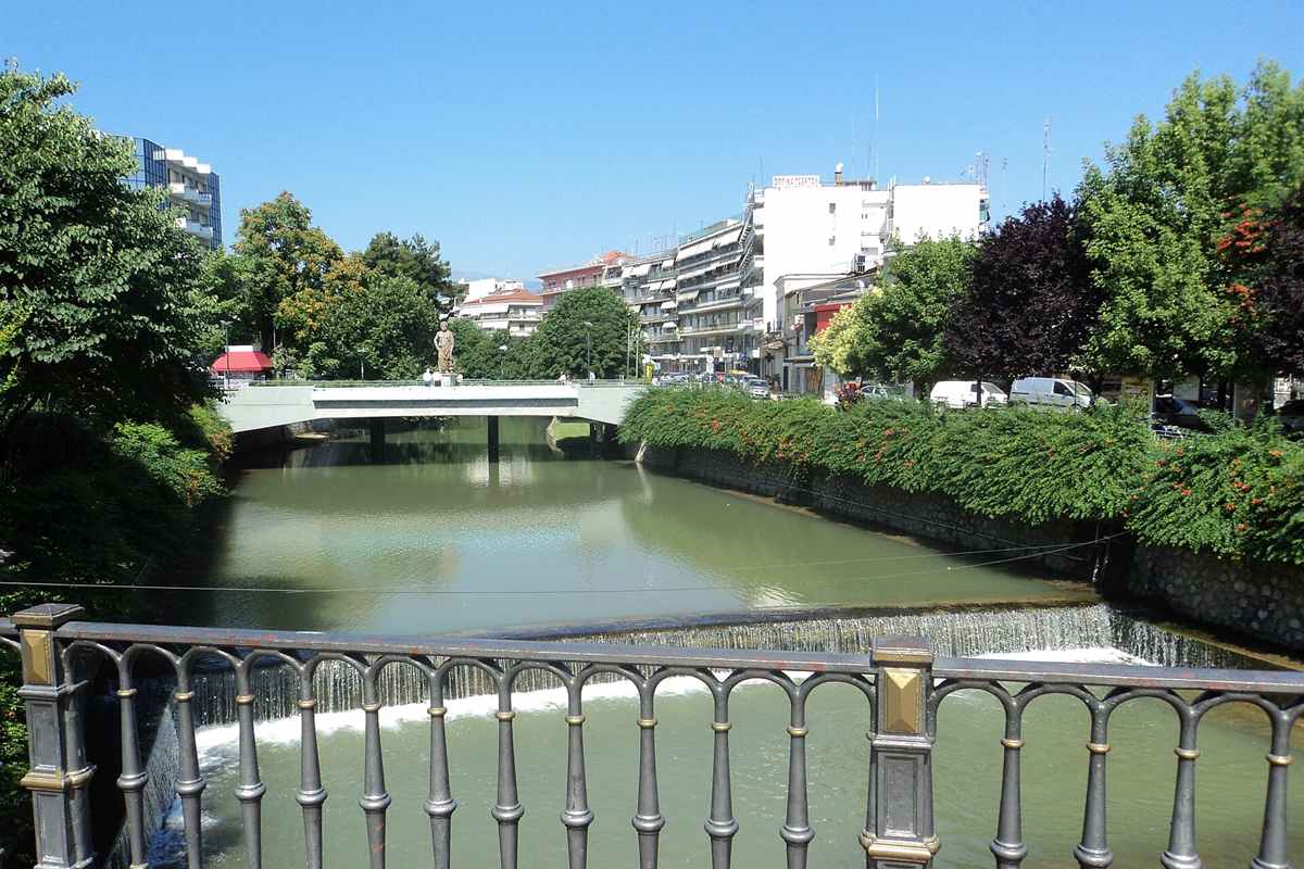
The Lithaios is a right tributary of the Pineios. It rises at 500 metres in the Antichasia mountains, runs for 36 kilometres and meets the Pineios at 108 metres, just outside the city. The municipality counts 13 bridges over the river in town, and half of them serve pedestrians only.
The arched Central Bridge took its metal parts from France and was finished at the end of 1888. It links the central square with the pedestrian street of Asklipiou. It became a listed monument in 1996 and gained architectural lighting in 2015. On another bridge, Trikala tours pass a statue of Asclepius by the sculptor Theodoros Vasilopoulos.
- Matsopoulos Mill: a historic industrial park and cultural centre whose machinery survives intact in its original place.
- Cinema and theatre: the mill also houses the Municipal Cinema and Theatre and a conference centre.
- Mill of Elves: the park has run since 9 December 2011 for 40 days a year, and over 1.8 million people visited its 11th edition.
- River pier: since 28 April 2016, a pier on the Lithaios has served the boats that take residents and visitors onto the river each spring.
What ancient past do Trikala tours trace?
Trikala tours trace ancient Trikke, a city founded around the 3rd millennium BC and named after the nymph Trikke. Tradition names Trikke as the birthplace of Asclepius, the god of healing, and Strabo called its Asklepieion the oldest and the best known in Greece.
Homer lists Trikke in the Catalogue of Ships of the Iliad. The city sent 30 ships to the Trojan War under Machaon and Podalirius, the sons of Asclepius. In the Mycenaean period, Trikke was the capital of a kingdom, and later it led the Thessalian district of Estiaiotis.
Trikala tours end at the archaeological site east of the church of Saint Nicholas on Sarafi Street. Rescue digs ran there from 1902 to 1992. The site shows a stoa building, a building with mosaic floors, a bath and a small Byzantine church of the 12th to 13th century. The Lycurgus mosaic shows the mythical king about to attack Ambrosia, the nurse of the god Dionysus.
- Bronze Age: pottery shows people on the west slopes of the acropolis from the Early Bronze Age, around 3300 BC.
- 480 BC: Trikke fell to the Achaemenid Persians.
- 352 BC: the city joined the Macedonia of Philip II.
- 168 BC: Trikke passed to the Roman Republic.
- Name: the name Trikala first appears in the 11th-century Strategikon of Kekaumenos.
How do Trikala tours reach Meteora and Kalambaka?
Trikala tours reach Meteora by road in about 20 minutes, over a distance of 21.94 km. Six monasteries still function on the sandstone rocks between Kalambaka and Kastraki, and UNESCO added the Meteora complex to the World Heritage List in 1988.
At their peak in the 16th century, the rocks held 24 monasteries. Until the 17th century, baskets and ropes carried people and goods to the top, and steps cut into the rock in the 1920s replaced the ladders. The full list of sites sits on the Meteora monasteries page.
Kalambaka lies at the foot of the Meteora massif, on the north bank of the Pineios, and is the seat of the Meteora municipality. Kastraki fills a small valley on the southwest side of the rocks, a 20-minute walk from Kalambaka. Trikala tours use both as bases, and the town has its own Kalabaka page.
- Great Meteoron: the oldest and largest monastery, founded by Athanasios the Meteorite between 1356 and 1372.
- Varlaam: the second largest monastery, rebuilt from 1517 by two brothers from Ioannina.
- Rousanou: a convent at 484 metres above sea level.
- St. Stephen: a convent since 1961, with a katholikon from 1798.
What do Trikala tours see at the Theopetra Cave?
Trikala tours see a limestone cave 3 km south of Kalambaka with traces of humans from at least 50,000 years ago. A stone wall dated to 23,000 years ago closed two-thirds of its entrance, and the cave sits in Theopetra village.
The cave holds one of the longest archaeological sequences in Greece, from the Middle Palaeolithic to the Neolithic. It records two shifts in one place: modern humans replacing Neanderthals, and farming replacing hunting and gathering after the last Ice Age. Excavations began in 1987 under N. Kyparissi-Apostolika.
The main chamber covers 500 square metres, and its entrance is 17 metres wide and 3 metres high. Trikala tours add the Theopetra Cave Museum in the village, a short walk from the cave.
- Stone wall: built while Earth was in an ice age, to close two-thirds of the entrance.
- Burials: DNA from two Mesolithic individuals, dated to 7605–7529 BCE and 7288–6771 BCE.
- Last residents: people left the cave around 2800 BC, at the end of the Neolithic.
Which Pindos villages do Trikala tours reach?
Trikala tours reach Pyli, 18 km west of Trikala, then climb to Elati at 921 metres and Pertouli at 1,150 metres. Pyli holds the Porta Panagia church of 1283 and a stone bridge built in 1514 over the Portaikos river.
Pyli sits at the foot of Mount Koziakas and Mount Itamos, where the Pindos range begins, and its name means “gate”. John I Doukas, ruler of Thessaly, founded Porta Panagia as the main church of a monastery. A fire in 1855 burned the original interior, but two mosaics on the eastern piers still show Christ and the Theotokos holding the Child.
Elati, once called Tyrna, lies in fir forest 31 km from Trikala and 13 km from Pyli. The municipality puts Pertouli at 46.27 km from the city, a drive of about 58 minutes.
- Pyli bridge: 67 metres long, built by St. Vissarion, and the only link between the plain and the Pindos villages until 1936.
- Pertouli: stone houses ringed by a forest of about 33,000 stremmata.
- Neraidochori: a village at 1,100 metres, 2.5 km from Pertouli, with Byzantine monuments.
- Palaiokarya: a waterfall and a 16th-century stone bridge, 4 km off the Pyli–Elati road.
What else do Trikala tours show around the regional unit?
Trikala tours also show the Monastery of St. Vissarion near Pyli, with 365 monk cells on Mount Koziakas, and the Aspropotamos area, about 40 km west of Trikala, where streams join to form the Acheloos river under peaks above 2,000 metres.
The monastery stands 2 km north of Pyli. St. Vissarion re-established it between 1527 and 1535, and its church dates from 1557. Women are not allowed inside. The nearby village was called Dousiko until 1955, and the monastery is also known as the Dousiko monastery. Porta Panagia has belonged to it since 1843, so Trikala tours link the two sites in one visit to Pyli.
Aspropotamos means “white river”. The area covers 297.082 km² of the southern Pindos at an average altitude of 1,087 metres, with its seat at Kallirroi.
- Frescoes: completed in November 1557 by the painter George from Constantinople.
- Goura monastery: a convent founded in 1743 on Mount Itamos, at 640 metres above Pyli.
- Aspropotamos villages: Chaliki, Krania, Anthousa and Polythea.
- Pineios river: 205 km long, rising near Malakasi and flowing past Kalambaka and Larissa.
How do visitors reach Trikala for Trikala tours?
Trikala tours start from a city 326.68 km from Athens and 213.84 km from Thessaloniki by road, and the Thessaloniki drive takes about 2 hours. The A3 motorway passes the city, and KTEL buses link it with both.
Rail reaches Trikala on the Palaiofarsalos–Kalambaka line, a branch of 80.44 km that opened on 16 June 1886. In 2001 it joined the Athens–Thessaloniki main line at Palaiofarsalos, and until 2023 InterCity trains linked Trikala with Athens, Larissa and Thessaloniki.
Storm Daniel struck Thessaly on 5 September 2023 and washed away parts of the track. No trains call at Trikala at present, and a rail-replacement bus runs between Kalambaka and Palaiofarsalos. Travellers based in the north can also compare the Meteora from Thessaloniki route.
- Road from Athens: 326.68 km, with KTEL buses on the route.
- Road from Thessaloniki: 213.84 km, about 2 hours.
- Road from Ioannina: 126.41 km, about 1 hour 30 minutes.
When do Trikala tours run best?
Trikala tours run best in winter and summer. The regional unit draws about one million visitors, mainly in the winter months of snow and skiing. Summer suits the mountain villages, since the plain reaches an August average high of 34.5 °C.
Trikala has a Mediterranean climate with a continental influence, and spring and autumn stay mild. Snow in the city stays light, but Pyli gets regular snowfalls each winter, averaging 30–40 cm. The Pertouli ski runs climb from 1,170 to 1,340 metres, though the low altitude has made the snow unreliable in recent winters.
The Christmas season lasts 40 days in Trikala, from late November to early January, with outings to Meteora, Pyli, Elati and the Pertouli Ski Centre. Trikala tours in summer turn to the forest paths around Elati.
- Winter: a small ski centre 7 km outside Elati on the road to Pertouli.
- Spring: mild weather and forest roads open to cars, mountain bikes and horses.
- Summer: hiking, trail running, mountain biking and rock climbing at Meteora.
Frequently Asked Questions
Do Trikala tours include protected nature at Meteora?
Yes. Meteora is a Natura 2000 protected area with the code GR1440003. Trikala tours cross its wooded hills, the river valleys of the Lithaios and the Mourgas, and plane and oak forests. Protected birds such as the Egyptian vulture breed there, along with owls and eagles.
Are Trikala tours possible in winter?
Yes. Winter is the busiest season for visitors to the regional unit. Trikala tours in the cold months reach the Pertouli Ski Centre on the Pertouli meadows, and Elati keeps a stamina-ski course of its own. Below Koziakas, the Hatzipetros shelter sleeps 20 people.
How far is the Theopetra Cave from Trikala for Trikala tours?
Theopetra village lies 15 km north of Trikala and 6 km southeast of Kalambaka, so Trikala tours pair it with a stop at Kalambaka. The cave sits just north of the village centre, within walking distance. Before 1928 the village carried the name Kouveltsi.
Can Trikala tours reach the Pindos by public bus?
Yes. Buses run almost every hour between Trikala and Pyli, and tickets to Pyli are sold directly from Athens and Thessaloniki. From Pyli, buses serve the surrounding mountain areas at least once a day, and a local taxi service operates in the town.