
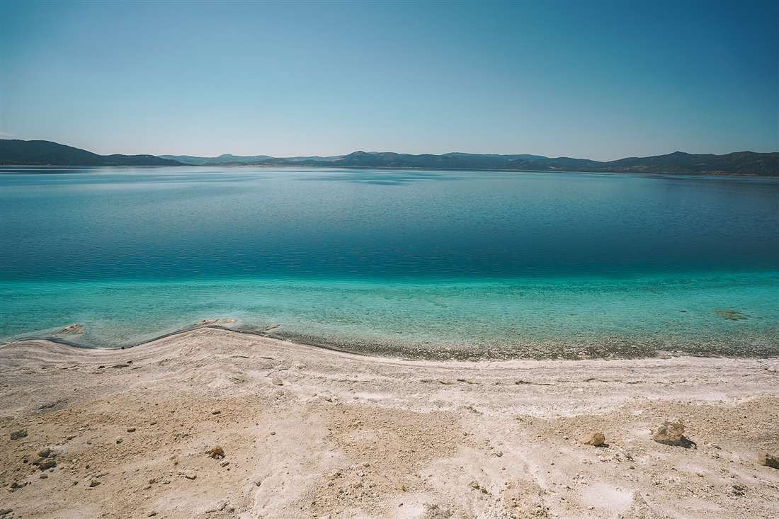
Salda Lake is a turquoise crater lake with dazzling white mineral shores in Burdur province, about 90 kilometres from Pamukkale. Called the “Turkish Maldives”, it is the deepest lake in Turkey and a NASA Mars analogue for the Jezero crater. Plan the whole trip with Greece Tours.
This guide covers Salda Lake in full: what it is and where it lies, why it is called the Turkish Maldives, why NASA studies it, how it formed, what the white shores are made of, whether you swim, the best beaches, the protection rules, the best time to visit, and how to reach it from Pamukkale, on a tour from Antalya.
What is Salda Lake?
Salda Lake is a turquoise crater lake in Burdur province, south-western Turkey, ringed by brilliant white mineral beaches. Its alkaline, mineral-rich water and hydromagnesite shores earn it the nickname the “Turkish Maldives”, drawing visitors to one of the country’s clearest lakes.
Salda Lake, known in Turkish as Salda Golu, sits inside a deep basin that formed along a tectonic fault. The lake reaches a depth of about 184 metres, which makes it the deepest lake in Turkey. Its water carries a high concentration of magnesium and carbonate minerals, and this chemistry gives the surface its striking gradient of turquoise, teal and deep blue. The colour intensifies near the pale shores, where sunlight reflects off the white mineral bed beneath the shallows.
The lake occupies a protected natural park in the Yesilova district, roughly 1,150 metres above sea level on the Anatolian plateau. Pine-covered slopes rise around the northern and eastern edges, and the white beaches spread along the western and southern shores. The combination of white sand, glassy turquoise water and forested hills creates a landscape that resembles a tropical lagoon transplanted into the Turkish interior. Visitors arrive for the swimming, the photography and the geological rarity of the place, and researchers arrive for the minerals that make Salda a scientific landmark.
Salda holds official status as a Special Environmental Protection Area, a designation that governs building, access and swimming to shield the fragile shore. The white deposits along the edge form slowly over centuries, so the protection rules keep visitors on designated beaches and away from the untouched microbialite formations. This balance of open recreation and strict conservation defines the modern experience of the lake.
The setting adds to the appeal. The lake sits within a nature park that spreads across the basin and the pine forest above it, and the elevation of the plateau keeps the summer air fresher than the coast below. Migratory birds pause on the water during their seasonal passage, wildflowers colour the slopes in spring, and the surrounding hills shelter the basin from the harsher weather of the open steppe. This blend of a rare turquoise lake, a white mineral shore and a forested mountain backdrop gives Salda a landscape that reads as one of the most distinctive in Turkey.
Where is Salda Lake and how far from Pamukkale?
Salda Lake lies in Burdur province in south-western Turkey, about 90 kilometres south-east of Pamukkale and Denizli. The drive takes around 90 minutes along the D585 and D330 roads, passing through the Yesilova district to reach the lake’s western shore.
The lake sits near the small town of Yesilova, which serves as the gateway settlement for visitors. From Denizli, the nearest large city and the transport hub for Pamukkale, the road heads south-east through rolling farmland and low mountain passes before descending into the Salda basin. The distance of roughly 90 kilometres translates to a comfortable drive of an hour and a half, which places the lake within easy reach of the Pamukkale travertines for a combined day out.
Salda’s provincial capital, Burdur, lies about 50 kilometres to the east, and the resort city of Antalya sits roughly 150 kilometres to the south beyond the Taurus mountains. This central position makes the lake a natural stop on routes that link the Aegean coast, the Pamukkale hot springs and the Mediterranean. Travellers reach the shore by car, by organised tour or by regional bus to Yesilova followed by a short local transfer to the beach entrance.
The proximity to Pamukkale drives the lake’s popularity as a paired excursion. A morning at the white travertine terraces and the ancient city of Hierapolis followed by an afternoon swim in Salda’s turquoise water forms one of the most popular itineraries in the region. For the wider context of the terraces and thermal pools nearby, the guide to Pamukkale sets out the route and the highlights that pair with a Salda visit.
Why is Salda Lake called the Turkish Maldives?
Salda Lake earns the “Turkish Maldives” nickname because its white mineral beaches and vivid turquoise shallows mirror the look of a tropical island lagoon. The pale hydromagnesite shore and the graded blue water create a coastal scene that resembles the Indian Ocean, set on the Anatolian plateau.
The visual comparison rests on two features. The first is the shore itself: instead of golden or grey sand, Salda’s beaches consist of fine white mineral deposits that reflect sunlight and read as pure tropical white in photographs. The second is the water, which shifts from a pale milky turquoise over the shallow white bed to deep sapphire in the central depths. Together these produce a colour palette that matches the postcard image of a Maldivian atoll, and this resemblance spread across social media until the nickname stuck.
The likeness sharpens in the calm mornings, when the surface lies flat and mirror-still. Wind stirs the lake through the afternoon, but at first light the turquoise band along the shore holds a glassy clarity that reveals the white bottom far out from the edge. Photographers travel to Salda specifically for this effect, framing the white beach, the turquoise water and the pine-clad hills in a single shot that looks tropical rather than continental.
The nickname carries a note of caution alongside the appeal. The surge in visitors that followed the “Turkish Maldives” fame put pressure on the delicate white shore, and authorities responded by restricting access to protect the mineral formations. The tropical resemblance draws the crowds, and the conservation rules exist precisely because that resemblance is so fragile.
Why did NASA study Salda Lake?
NASA studied Salda Lake because its hydromagnesite mineral deposits and microbialite structures closely match the geology of the Jezero crater on Mars. The lake serves as an Earth analogue for the Perseverance rover mission, which explores an ancient Martian lakebed for signs of past microbial life.
The Jezero crater once held a lake fed by rivers, and orbital data revealed carbonate minerals along its former shoreline. Carbonates preserve chemical and biological traces exceptionally well, which made Jezero a prime landing target in the search for ancient life. Salda contains the same class of magnesium carbonate minerals, formed in a similar shallow alkaline setting, so it offers scientists a living laboratory to understand how such deposits build up and what signatures they trap.
The microbialites are the key link. Along Salda’s shore, colonies of microbes bind and precipitate hydromagnesite into layered mounds and crusts, and these structures resemble the features expected around Jezero’s ancient margin. By sampling and mapping Salda’s shoreline, researchers from NASA and Turkish institutions built a reference for interpreting the rocks that Perseverance encounters. The rover collects and caches samples for a future return to Earth, and Salda’s minerals help scientists decide what to look for and how to read the results.
This partnership turned a Turkish crater lake into a globally significant site for planetary science. The white shore that photographs like a tropical beach carries, in geological terms, a direct chemical parallel to a distant Martian basin, and that dual identity of holiday destination and Mars analogue makes Salda unique among the lakes of the world.
How was Salda Lake formed?
Salda Lake formed in a tectonic basin created by faulting in the Earth’s crust, which produced a deep enclosed depression that filled with water. The lake sits in a graben-style crater, has no major outflowing river and reaches about 184 metres deep, making it the deepest lake in Turkey.
The basin belongs to a system of fault lines that fracture south-western Anatolia. Movement along these faults dropped a block of crust to create the steep-sided hollow the lake now occupies. Groundwater, springs and seasonal rainfall feed the basin, and because the lake lacks a strong surface outlet, dissolved minerals concentrate in the water rather than draining away. This closed hydrology is the engine behind Salda’s distinctive chemistry.
The surrounding bedrock is rich in magnesium, and water percolating through it carries that magnesium into the lake. Inside the alkaline water, magnesium combines with carbonate to precipitate hydromagnesite, a soft white mineral that settles onto the lakebed and builds up along the shore. The great depth keeps the central water cold and stable year-round, while the shallow margins warm in summer and stay clear over the pale mineral floor.
The result is a lake defined by its geology at every level: a fault-carved crater for a basin, a magnesium-loaded catchment for a source, and a closed system that turns dissolved minerals into the white deposits that ring the shore. Each feature that visitors admire, the depth, the colour and the white beaches, traces directly to how the basin came into being.
What are the white beaches and shores made of?
Salda’s white beaches consist mainly of hydromagnesite, a soft magnesium carbonate mineral, mixed with fine white clay. The lake’s alkaline water precipitates hydromagnesite along the margin, and wave action grinds it into a pale, powder-fine sediment that forms the brilliant white shore.
Hydromagnesite is a hydrated magnesium carbonate that forms in alkaline, magnesium-rich lakes precisely like Salda. Microbial activity in the shallows accelerates its precipitation, binding the mineral into crusts and mounds known as microbialites. Over long periods these deposits break down and redistribute along the shore, creating banks of chalk-white material that read as sand to the eye and touch but consist of pure carbonate mineral rather than quartz grains.
The accompanying white clay adds to the effect and gives rise to a popular ritual: visitors coat their skin in the smooth mineral mud drawn from designated shallows. The clay holds a fine, silky texture, and its reputation as a skin treatment turned the white mud into part of the Salda experience. Authorities channel this activity to specific zones to keep the untouched hydromagnesite formations intact.
The whiteness of the shore is therefore an active geological process, not a fixed feature. The minerals form slowly through chemistry and microbial life, and they renew over decades and centuries rather than seasons. This slow build-up is the reason the protection rules matter: heavy foot traffic and extraction strip the white material faster than the lake replaces it, which is why access to the most pristine banks stays restricted.
Is swimming allowed at Salda Lake?
Yes, swimming is permitted at Salda Lake within designated beach zones inside the nature park. The shallow margin over the white mineral bed warms in summer and offers clear, shallow bathing, while the deep central water stays cold. Protected areas along the shore remain closed to swimmers to preserve the mineral formations.
The designated beaches provide the safe and legal places to enter the water. Here the lakebed slopes gently, the shallows warm through the summer months and the water holds a startling clarity over the pale floor. Bathers wade out across firm white sediment before the bottom drops toward the deep basin, and the graded turquoise water makes the shallow zone especially inviting for a swim on a hot day.
The depth demands respect. Salda plunges to about 184 metres, and beyond the shallow margin the temperature falls sharply. The cold deep water and the steep underwater profile mean strong swimmers stay within the marked areas rather than striking out toward the centre. Lifeguard-supervised beaches and roped zones keep bathers in the safe band close to shore.
The alkaline chemistry adds a further note. The water carries a high pH from its dissolved carbonates, so swimmers rinse off afterwards and keep the mineral water out of the eyes. Within these sensible limits, a Salda swim ranks among the most memorable in the region, combining the white beach, the clear turquoise shallows and the mountain air of the Anatolian plateau.
What is the best beach at Salda Lake?
The main public beach inside the Salda Lake Nature Park offers the most accessible swimming, with facilities, parking and supervised shallows. The White Islands area, known in Turkish as Beyaz Adalar, holds the most famous white shore, though access there stays restricted to protect the fragile hydromagnesite formations.
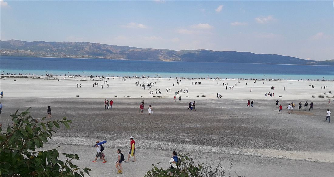
The nature park beach is the practical choice for most visitors. It sits on the northern and eastern side of the lake, provides car parking, changing facilities and refreshment stands, and marks out safe swimming zones over the white bed. The gentle slope and warm shallows make it suited to families, and the managed layout spreads visitors along the shore without crowding the delicate margins.
The White Islands, or Beyaz Adalar, form the postcard image of Salda. Here the hydromagnesite banks reach their most brilliant white, and the turquoise water pools in bright lagoons between the mineral spits. This is the scene that inspired the “Turkish Maldives” comparison. To guard these formations from erosion, authorities restrict foot access and cordon off the most pristine banks, so visitors admire and photograph the islands from permitted vantage points rather than trampling across them.
The choice of beach therefore balances access against pristineness. The public park beach delivers the swim, the facilities and a fine stretch of white shore, while the White Islands deliver the iconic view under conservation control. A visit that combines a swim at the park beach with a walk to a permitted White Islands viewpoint captures the full character of the lake.
Is Salda Lake protected?
Yes, Salda Lake holds status as a Special Environmental Protection Area under Turkish law, and its surroundings form a designated nature park. The rules limit construction, restrict access to the white mineral shore and channel swimming into set zones, all to preserve the hydromagnesite formations that make the lake globally significant.
The Special Environmental Protection Area designation governs the entire basin and its catchment. It controls building near the shore, regulates vehicle access and prohibits activities that disturb the mineral banks. The measure followed a surge in visitor numbers after the lake’s rise to fame, when uncontrolled foot traffic and off-road driving damaged the white deposits and threatened the microbialite structures along the margin.
Management of the site now channels visitors through the nature park entrance, concentrates swimming and picnicking in prepared areas, and fences off the most fragile stretches of the White Islands. Rangers enforce the boundaries, and signage explains why the pale shore demands protection: the hydromagnesite forms over centuries, so a single busy season strips material the lake replaces only across decades. The scientific value of the site, as a Mars analogue and a rare carbonate lake, reinforces the case for strict conservation.
These rules shape the visitor experience in concrete ways. Access to certain banks stays closed, camping falls under permit, and the untouched white islands stay off-limits to feet. Far from diminishing the visit, the protection preserves the very features, the clarity, the whiteness and the turquoise water, that draw people to Salda in the first place.
When is the best time to visit Salda Lake?
The best time to visit Salda Lake runs from late spring through early autumn, when warm days heat the shallow water enough for swimming and the lake holds its clearest turquoise clarity. The peak summer months bring the largest crowds, so a visit in the shoulder seasons trades warmth for quieter shores.
Late spring opens the swimming window as the shallow margin warms and the meltwater clarity peaks. The surrounding pines stand green, wildflowers dot the hills, and the crowds stay thin before the school holidays begin. This period delivers the sharpest turquoise water and the calmest mornings for photography, when the mirror-flat surface reveals the white bed far out from the shore.
High summer brings the warmest bathing and the busiest beaches. The nature park fills through July and August, the car parks reach capacity by mid-morning, and the shore hums with day-trippers from Pamukkale, Antalya and beyond. An early arrival secures parking and a stretch of quiet water before the crowds build, and the calm dawn hours reward the effort with the best light and the stillest surface. Weekdays draw thinner crowds than weekends, and an arrival before nine in the morning secures both parking and a clear stretch of water even at the height of the season.
Early autumn reopens the quieter window. The water retains its summer warmth into September, the crowds thin as the holidays end, and the clear conditions return. Winter turns cold and windy on the exposed plateau, and swimming stops, though the white shore against a moody sky holds its own stark appeal for photographers who brave the chill. For swimming and the full turquoise spectacle, the warm half of the year remains the answer.
How do you visit Salda Lake from Pamukkale?
You reach Salda Lake from Pamukkale by driving about 90 kilometres south-east through Denizli and Yesilova, a journey of roughly 90 minutes. Organised day tours combine both sites, pairing a morning at the Pamukkale travertines with an afternoon swim at Salda, which makes the two a natural single-day itinerary.
The self-drive route leaves Pamukkale, joins the road toward Denizli and then follows the D585 and connecting roads south-east across the plateau to the Yesilova district. The drive crosses farmland and low passes before descending to the Salda basin, and signposts direct visitors to the nature park entrance on the shore. A hire car gives the freedom to time the visit around the crowds and to linger at the beach as long as the light lasts.
Organised tours package the logistics for travellers without a car. A typical excursion collects visitors in the morning, spends the first half of the day among the white travertine terraces and the ruins of Hierapolis at Pamukkale, then transfers to Salda for swimming and photography in the afternoon before returning by evening. This structure suits the geography, since the sites lie close enough to enjoy both without rushing. For those approaching the region from the Mediterranean coast, the guide to Pamukkale from Antalya sets out the longer transfer that connects the coast to these inland wonders.
The timing rewards an early start. Reaching Pamukkale near opening keeps the morning cool for the terraces, and arriving at Salda in the early afternoon leaves ample time to swim, walk the shore and photograph the White Islands before the light softens. Pairing the two turns a single day into a contrast of white travertine and turquoise lake, two of Turkey’s most photographed landscapes within an easy drive of each other.
What is there to do at Salda Lake?
At Salda Lake visitors swim in the clear turquoise shallows, coat their skin in the silky white mineral mud, walk the white beaches, picnic under the pines and photograph the tropical-looking shore. Camping falls under permit inside the nature park, and the calm dawn draws photographers to the mirror-still water.
Swimming heads the list. The shallow margin over the white bed warms through summer and offers clear, refreshing bathing within the designated zones, with the graded turquoise water making every dip photogenic. Alongside the swim, the white mud ritual draws crowds to the permitted shallows, where visitors smooth the fine hydromagnesite clay over their skin and let it dry before rinsing off in the lake, a treatment tied to the mineral chemistry of the water.
Walking the shore reveals the geology up close. The white banks curve along the western and southern edges, the microbialite formations rise near the water line, and the pine-covered slopes frame the turquoise expanse. Picnic areas under the trees provide shade for a lunch by the water, and the nature park sets aside permitted zones for camping under the stars, subject to the protection rules that govern the site.
Photography completes the experience. The calm mornings deliver mirror reflections of the hills and the clearest view of the white bed beneath the surface, and the White Islands supply the iconic “Turkish Maldives” frame from permitted vantage points. Between the swimming, the mud, the walks and the camera, Salda fills a full day of the plateau’s rare turquoise light, and it rewards the visitor who arrives early and stays for the shifting colours of the water through the afternoon.
How deep is Salda Lake?
Salda Lake reaches a maximum depth of about 184 metres, which makes it the deepest lake in Turkey. The steep-sided basin drops away sharply beyond the shallow white margin, so the water plunges from a warm bathing shelf into a cold, dark central column within a short distance of the shore.
The great depth traces directly to the lake’s origin in a fault-carved crater. Rather than a broad, gently dished pan, Salda fills a narrow, deep hollow with abrupt underwater walls. The shallow shelf that swimmers enjoy occupies only a thin band around the edge, and past it the floor falls steeply toward the 184-metre low point at the centre of the basin.
This depth shapes the lake’s character in every season. The deep water holds a stable, cold temperature year-round and stays largely undisturbed by the surface heating that warms the shallows in summer. The volume of cold water below acts as a reservoir that keeps the central lake clear and blue, and it explains the sharp colour boundary between the pale turquoise shelf and the deep sapphire heart of the lake. The depth also underlines the safety rule: bathers stay on the marked shelf, because the drop to cold, deep water lies only metres out.
What colour is the water at Salda Lake and why?
Salda Lake’s water ranges from milky turquoise over the white mineral shelf to deep sapphire blue in the central depths. The colour comes from sunlight reflecting off the pale hydromagnesite bed in the shallows and from the scattering of light through the clear, deep alkaline water further out.
In the shallow margin, the white mineral floor sits close beneath the surface, and sunlight passes through the clear water, strikes the pale bed and bounces back. This reflection produces the bright, milky turquoise that gives the shore its tropical look. The whiter and shallower the bottom, the more luminous the turquoise, which is why the band closest to the White Islands glows most vividly.
Further from shore the floor drops away and the white bed disappears from view. Here the colour deepens to rich blue, because the clear water scatters and absorbs light through a long, deep column with no pale bottom to reflect it. The result is a continuous gradient from pale turquoise at the edge to dark sapphire at the centre, a single sweep of colour that shifts with depth. The clarity of the alkaline water sharpens every shade, since the mineral chemistry keeps the lake free of the murk that dulls colour in ordinary lakes.
What facilities are at the Salda Lake Nature Park?
The Salda Lake Nature Park provides car parking, changing rooms, toilets, refreshment stands and marked swimming zones along the managed shore. Rangers supervise the site, signage explains the protection rules, and designated picnic and camping areas sit under the pines within the park boundary.
The park concentrates visitor facilities on the accessible northern and eastern side of the lake, which keeps the fragile White Islands to the west and south free of heavy infrastructure. Arriving visitors park at the entrance, pass through the managed gateway and reach a prepared beach with changing rooms, toilets and stalls selling drinks and snacks. The layout channels foot traffic onto durable ground and away from the untouched mineral banks.
Beyond the beach, shaded picnic spots under the pine cover give families a place to spend the day, and permitted camping zones allow overnight stays under the conservation rules. The supervised swimming areas mark the safe bathing shelf with buoys, and rangers keep bathers within the band close to shore. This managed environment balances comfort and access against the strict need to protect the hydromagnesite formations, so visitors find the practical amenities of a beach resort within a tightly controlled nature reserve.
How do you get to Salda Lake from Antalya?
Salda Lake lies about 150 kilometres north of Antalya, a drive of roughly two and a half hours across the Taurus mountains and onto the Anatolian plateau. Travellers reach the lake by hire car, by organised tour or by bus to Burdur or Yesilova followed by a local transfer to the shore.
The road from Antalya climbs north through the Taurus range, crosses high mountain passes and descends onto the plateau near Burdur before turning west toward Yesilova and the Salda basin. The scenic route rewards the drive with sweeping mountain views, and a hire car gives the freedom to combine Salda with the Pamukkale travertines further west in a single loop from the coast.
Organised excursions from Antalya package the transfer for travellers without a car, and the popular versions pair Salda with Pamukkale to justify the distance. These tours leave the coast early, cross the mountains in the morning and deliver a full day inland before returning by evening. Public buses connect Antalya with Burdur and the regional towns, from where a local transfer covers the final stretch to the lake, though the drive and the organised tour remain the direct routes for a comfortable day trip to the turquoise water.
Why is the water at Salda Lake so clear?
Salda Lake’s water stays exceptionally clear because its high alkalinity and mineral chemistry suppress the algae and organic murk that cloud ordinary lakes. The magnesium-rich, high-pH water carries little suspended sediment, and the white mineral bed reflects light through the clean shallows, producing striking visibility over the pale floor.
The alkaline chemistry is the primary cause. The dissolved carbonates raise the water’s pH to a level that limits the growth of the plankton and algae responsible for the green tint and reduced visibility in most lakes. With that biological load held down, the water holds almost no particles to scatter light, so the surface reveals the mineral bed far out from the edge on a calm morning.
The closed hydrology reinforces the clarity. Salda receives its water from springs, groundwater and rainfall rather than from muddy inflowing rivers that carry silt, so little suspended sediment enters the basin. The great depth further helps, drawing settling particles down into the still cold column below and leaving the shallow shelf clean and bright. Together the chemistry, the sediment-poor inflow and the depth keep Salda among the clearest lakes in Turkey, and that transparency is what lets the turquoise colour of the mineral shallows read so vividly.
What makes Salda Lake unique among Turkey’s lakes?
Salda Lake stands apart as the deepest lake in Turkey at about 184 metres, one of a rare group with brilliant white hydromagnesite beaches, and the only Turkish lake studied by NASA as a Mars analogue. Its combination of turquoise clarity, mineral shores and scientific fame is matched nowhere else in the country.
Turkey holds hundreds of lakes, from the vast salt expanse of Lake Van to the shallow bird havens of the Anatolian basins, yet none pairs the features Salda concentrates in a single crater. The depth places it first among Turkish lakes, the hydromagnesite shore gives it a white beach found in only a rare set of alkaline lakes worldwide, and the graded turquoise water sets it apart from the muddier or greener lakes of the region.
The scientific dimension seals its uniqueness. The direct chemical parallel to the Jezero crater turned Salda into a reference site for the Perseverance mission, a distinction no other lake in Turkey holds. That a place famous as the “Turkish Maldives” also serves as a stand-in for an ancient Martian lakebed captures the dual identity at the heart of Salda: a holiday shore and a planetary laboratory in one turquoise basin on the Anatolian plateau.
Frequently Asked Questions
What is Salda Lake?
Salda Lake is a deep turquoise crater lake in Burdur province, Turkey, ringed by white hydromagnesite beaches. Called the Turkish Maldives, it is the deepest lake in the country at about 184 metres and a NASA Mars-research analogue.
Why did NASA study Salda Lake?
NASA studies Salda Lake because its white hydromagnesite and microbialites match the minerals in the Jezero crater on Mars, the landing site of the Perseverance rover. The lake serves as an earthly analogue for the search for ancient Martian life.
How do you visit Salda Lake from Pamukkale?
Salda Lake lies about 90 kilometres south-east of Pamukkale, a 90-minute drive through Burdur. Day tours from Pamukkale, Antalya and Fethiye pair the white lake with the travertines, and self-drive reaches the beach car parks directly.