
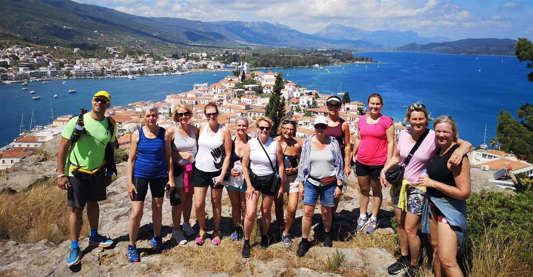
A Poros hiking tour climbs the Three Peaks above the town, follows the pine trails of Kalavria and crosses the strait to the Lemon Forest of Galatas. More guided walks around the country are listed on Greece Tours.
Read on for the bookable hike, the routes, the sights, seasons, kit, ferries and food.
What is a Poros hiking tour?
A Poros hiking tour is a guided walk on the island’s footpaths. Routes climb the hills above Poros Town, cross the pine forest of Kalavria or follow the coast, with wide views over the Saronic Gulf and the strait to Galatas.
The island gives walkers three kinds of ground. Each one gets its own section further down this page.
- Hills above Poros Town: paths that rise over the town and its harbour.
- Pine forest of Kalavria: trails through old pine woods in the centre of the island.
- The coast: shoreline paths that face Galatas and the Peloponnese across the water.
Poros is an island pair in the southern Saronic Gulf, about 58 km (31 nautical miles) south of the port of Piraeus. Sphairia, the southern part, is volcanic in origin and holds the town. Kalavria, the northern part, is the larger one, and its name means “gentle breeze”.
A bridge crosses the narrow strait between Sphairia and Kalavria. On the far side, a sea channel only 200 m wide separates Poros island from the Peloponnese. The town of Galatas sits on the mainland shore of that channel.
Every Poros hiking tour crosses very hilly ground on an island of about 31 square kilometres, home to about 3,260 people. Large areas of old pine forest cover the south and centre. Like other Saronic ports, Poros is a popular weekend escape for travellers from Athens.
Under the paths, limestone and sandstone mix with volcanic rock on Sphairia. Karst sinkholes pit the limestone heart of the island, and its caves hold stalactites. Marine fossils show in the limestone, so keep an eye on the rocks beside the trail.
Which Poros hiking tour can you book?
The Poros hiking tour sold through GetYourGuide is “Poros: Three Peaks City Tour Hiking with Fresh Lemonade”. It is a 2.5-hour guided hike to the Three Peaks, with fresh lemonade and views over the Saronic Gulf and the canal.
The tour joins a town walk with a hill hike, as its name shows. The canal named on its card is the sea channel between Poros Town and Galatas. The card lists these booking terms:
- Languages: English and French
- Group per booking: 1 to 20 people
- Booking deadline: at least 10 hours before the start
- Cancellation: free cancellation
The card sets one ticket type, “Adult”, for everyone aged 99 and younger. It lists no minimum age, so children join this Poros hiking tour on the same ticket as their parents.
Free cancellation means a Poros hiking tour booked early carries no risk if your plans change. The 10-hour cut-off still leaves room for a booking made the day before.
Island-hopping trips that stop on Poros, such as the Hydra and Poros tour, are sightseeing trips and not hikes, so they do not replace a Poros hiking tour.
What does the Three Peaks Poros hiking tour cover?
The Three Peaks Poros hiking tour is a guided hike to three high points above Poros Town. The route links the island’s landmarks. It opens panoramic views over the Saronic Gulf and the narrow strait, which the tour calls the canal.
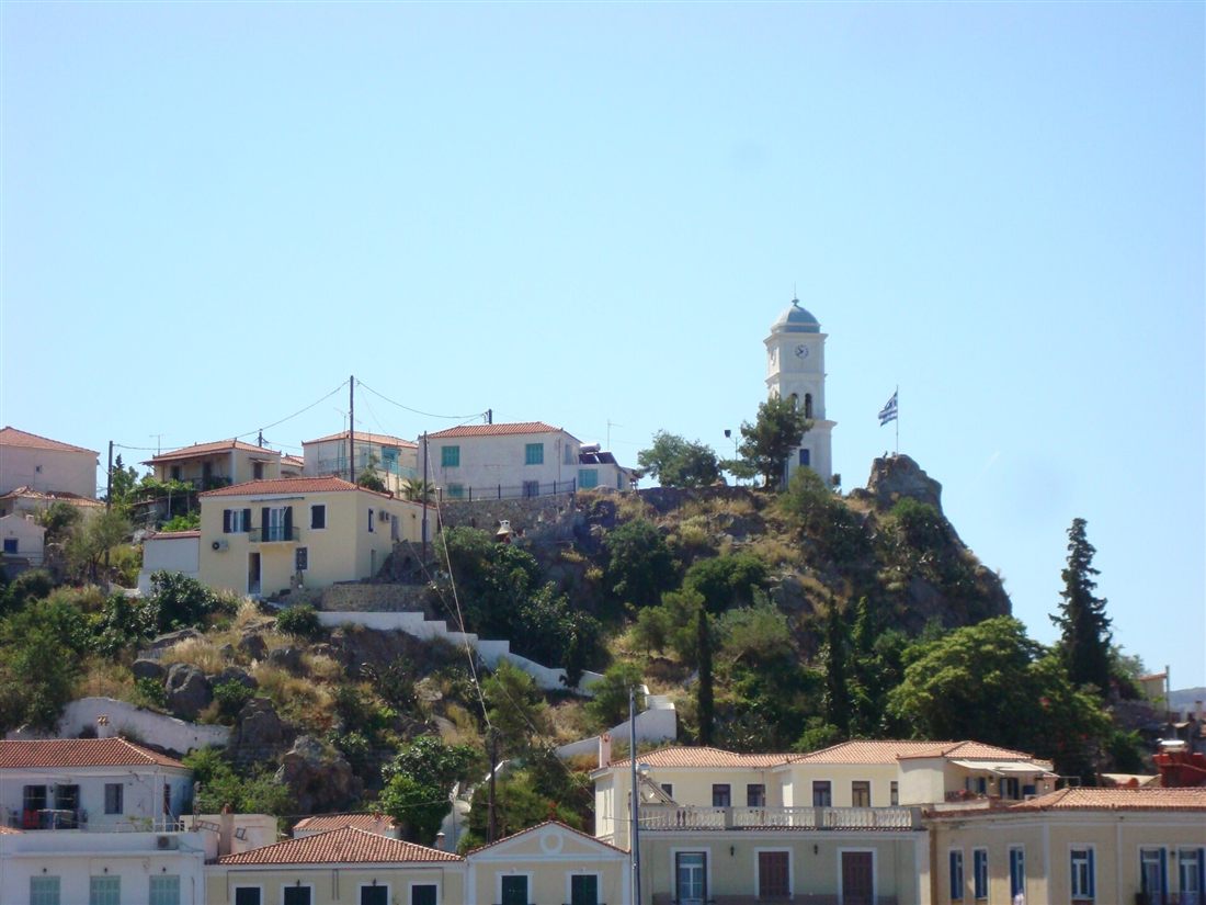
Poros Town sits on Sphairia, the small southern island of the pair. The town is built like an amphitheatre on the slopes of a hill, with neoclassical buildings. A Poros hiking tour of the Three Peaks climbs up through these tiers of houses.
The town’s famous landmark is a clock tower. The tour card does not list each stop by name. It promises the island’s landmarks and wide views instead. Each of the three peaks is a lookout over the rooftops, the harbour and the open Saronic Gulf.
The widest view looks across the strait to Galatas on the Peloponnese coast. The writer Henry Miller said that sailing into Poros felt like sailing through the streets. From above, you see why: the two shores sit so close. This view is the main reward of a Poros hiking tour.
How hard is a Poros hiking tour?
A Poros hiking tour of the Three Peaks is a short town walk. It has steep bursts on stone steps and narrow lanes. Each climb is brief and ends at a viewpoint. Steady legs and grippy shoes matter more than speed.
The card lists the walk at 2.5 hours, which leaves time to pause at each top. The effort comes in short spells. You climb a lane or a flight of steps, stop for the view, then walk on. On a Poros hiking tour of the town, these pauses keep the pace gentle for walkers of average fitness.
A longer Poros hiking tour on Kalavria, the pine-covered northern island, follows forest tracks over greater distances, with more climbing. Pick one of those only once the town route feels easy to you.
Heat changes the effort more than distance does. Treat the hilltops as open to the sun and plan around it. Start early in the morning or late in the afternoon in summer. Carry water and a hat, and drink at each stop.
Footwear matters on the stone steps. Old steps get worn smooth and turn slippery when damp or dusty. Wear trainers or light hiking shoes with firm, grippy soles, and leave flip-flops for the beach. On the way down, take the steps slowly and use handrails where they exist.
Descents load the knees more than climbs do. Walkers with sore knees can bring a walking pole for the downhill steps. Tell the guide about any health limits before the start. Then the group pace suits everyone on a Poros hiking tour.
Which trails cross Kalavria on a Poros hiking tour?
A Poros hiking tour crosses Kalavria on Poros Trails, the island’s network of marked paths. Kalavria is the northern and largest part of the island. The network’s trails begin within walking distance of the town, so walkers set off on foot.
Vigla, the highest peak of the island, reaches 358 metres, west of the centre of Kalavria. The western and northern sides roll in smooth hills and shallow valleys. The northern edge and the far eastern and western sides are bushy. The trail project describes Kalavria as green and well-watered.
The Municipality of Poros created Poros Trails with Paths of Greece. Every route is signposted and waymarked in detail with red-and-white marks. On a Poros hiking tour, walkers follow these marks between the town and the sights of Kalavria. Route names, lengths and maps are in the Outdooractive app, which the project site points to.
Plan a Kalavria route for the morning. The forest paths give shade, but the climbs out of the pines face the sun. No source confirms water points along the trails, so carry all the water you need from town.
Can a Poros hiking tour reach the Sanctuary of Poseidon?
Yes. A Poros hiking tour can reach the Sanctuary of Poseidon in the northern part of Kalavria. Its ruins stand on a hilltop. Poros Trails lists the temple among the sights its paths reach, so walkers arrive on foot.
In ancient times the sanctuary was the centre of the Kalaurian League. The geographer Strabo called it a league of seven cities that shared in the sacrifice. His list ran from Athens, Aegina and Epidaurus to Hermione, Nauplia, Prasiai and Orchomenus in Arcadia. Argos paid the dues for Nauplia, and Sparta paid them for Prasiai.
No archaeological evidence confirms Strabo’s list. Modern scholars see the league as a later Hellenistic invention. Still, a plaque marking a revival of the league has been found. So a feast in its name did take place.
The orator Demosthenes fled to this sanctuary to avoid arrest by Archias of Thurii, a confidant of Antipater. He took poison from a reed, pretending he wanted to write a letter to his family. He died there, at the sanctuary of the sea god.
A Poros hiking tour reaches ruins, not a standing temple. Little of the temple was left by the time Swedish archaeologists first dug the site. The Swedish Institute in Athens later resumed the excavations. The remains include:
- the Late Archaic Doric temple, which measured 27.4 m in length and 14.4 m in width, with a row of six columns at each end and twelve along each side
- Stoa D, a simple colonnaded hall, now poorly preserved
- Building E, read as the sanctuary’s entrance gateway, in better condition
Does a Poros hiking tour pass the Monastery of Zoodochos Pigi?
A Poros hiking tour that heads east along Kalavria can end at the Monastery of Zoodochos Pigi. The monastery stands on a pine-covered slope about 4 km east of Poros town. It was built around the island’s only spring.
Local tradition says Archbishop Iakovos II of Athens drank water from this spring and was cured of his illness. In thanks, he founded the monastery on the spot in the 18th century. Its main church is a basilica with a dome and a tower-like belfry. A small chapel of the Saints Anargyroi stands close by.
The walk follows the coast road east from town. It passes the beaches of Kanali and Askeli, then the cove of Monastiri on the last stretch. A Poros hiking tour can swap parts of the road for forest paths, since the island’s trails are signposted and waymarked. Local buses run from the harbour to Monastiri for the ride back.
The monastery is a place of worship where monks from Mount Athos once found refuge. On a Poros hiking tour, pack a light layer to cover your shoulders and knees before you enter. Keep your voice low inside the church, and ask before you take photos.
Which coastal walks suit a Poros hiking tour?
A Poros hiking tour along the shore suits walkers who want flat ground, pine shade and swim stops. The coastal targets are Love Bay, Russian Bay, the Dana lighthouse and the sandy beaches on the south coast of Kalavria.
- Love Bay (Agapi): a small sandy cove under pine trees, about 4 km north-west of town, with a beach canteen and sunbeds.
- Russian Bay: a sandy bay about 5 km north-west of town. The carved stone ruins of an old Russian naval supply station line the beach, and they are a protected monument. Its beach is organised and wheelchair accessible.
- Dana lighthouse: a square stone lighthouse at the entrance of Poros Bay, built by the French Society of Ottoman Lighthouses.
- South coast beaches: Kanali, Askeli and Monastiri. The sandy beaches of Poros sit on this southern shore, with one bay in the north as the exception.
The shore walks stay near sea level, on roads and tracks beside the water. The climbs begin once a path turns inland, where the hills rise under the pines. A Poros hiking tour that mixes both gives sea views from the slopes and a swim at the finish. Carry cash for the beach canteens, since small kiosks do not always take cards.
Love Bay and Russian Bay sit on the west side of Kalavria, while Askeli lies on its south-east side. Linking both sides on foot in one day means a long walk through town. A Poros yacht charter reaches the coves by sea. A Poros hiking tour can then cover one shore on foot after a boat drop-off.
Can a Poros hiking tour cross to the Lemon Forest of Galatas?
Yes, a Poros hiking tour can cross the narrow strait to Galatas, the mainland town facing Poros. From the quay, the route heads about 3 km out of town to Lemonodasos, the Lemon Forest at Artimos, on the road to Porto Heli.
The boat ride across the strait is short, so the mainland sits within easy reach of the island. This quick hop lets a Poros hiking tour add a mainland stage to a day on the island.
Lemonodasos means “lemon forest” in Greek. Its groves hold lemon and orange trees on the shore opposite Poros harbour, and it is a popular spot for school trips. The travel writer Sir Patrick Leigh Fermor made the place famous. Henry Miller, writing about Poros, also mentioned “the lemon groves just opposite us.”
The forest has natural springs, water mills and walking trails. Its old Kardasi mill once ground flour with the power of a waterfall, but it no longer runs. The trails carry poor signs, and fences close off private groves. A guide on a Poros hiking tour helps walkers find the open paths.
Allow half a day for the mainland stage. The boat crossing, the walk out to the groves and the return to the quay add up, so start early if you also plan a swim later.
Can a Poros hiking tour reach ancient Troezen?
Yes, a Poros hiking tour can reach ancient Troezen, near the village of Trizina on the Argolid Peninsula. Walkers visit the city linked with the hero Theseus in myth, then follow a footpath into the gorge of the Devil’s Bridge.
Troezen lies southwest of Athens, across the Saronic Gulf. The volcanic peninsula just to its north is the goal of a Methana day trip from Athens. In myth, Aethra, daughter of Pittheus, became pregnant with Theseus here. He lifted a great boulder when he came of age. Euripides set his tragedy Hippolytus in this city.
The ruins lie close to modern Trizina. They include a Hellenistic tower, the remains of a Byzantine church and an ancient asclepium, a healing sanctuary. Springs in the gorge supplied that sanctuary with water. Myth also places a spring in the old city where the winged horse Pegasus came to ground. In antiquity, the city went by the name Apollonia.
From Trizina, a dirt road climbs for about fifteen minutes to the gorge. Oleanders, plane trees and century-old trees line its banks. A small river runs down between huge rocks and forms little pools. An old stone arch, the Devil’s Bridge, spans the gorge. Local lore links hoof marks on the bridge to the god Pan.
A footpath continues past the bridge to a natural clearing, where visitors to the archaeological site rest. Torrents have worn the rock smooth over time, so slip-proof shoes matter on any Poros hiking tour that reaches this spot. The whole area is classed as a Landscape of Special Natural Beauty.
Which season suits a Poros hiking tour?
Spring and autumn suit a Poros hiking tour, with mild, comfortable days. Summer brings strong heat, so start at dawn and finish before noon. Winter is the wettest season, bringing cooler air and muddy paths after each rain.
The closest climate record comes from neighbouring Hydra, using National Observatory of Athens data. Both belong to the Saronic Islands. Hydra has a hot semi-arid climate and about 390 mm of rain a year. Its spring highs climb from 17°C in March to 21°C in April. Rain falls from 36 mm in March to 19 mm in April.
July and August average highs of 33°C, with only 1 to 2 mm of rain each month. On a summer Poros hiking tour, rest in shade every hour and drink before you feel thirsty. The pine forest dries out in these months, so a single spark can start a wildfire.
Highs ease from 29°C in September to 24°C in October, and the rain returns. From November to January, about 60 mm falls each month. Winter highs sit between 15°C and 17°C. In this season, pick a dry day for a Poros hiking tour. Shorter winter days also leave less light for long routes.
What do you pack for a Poros hiking tour?
For a Poros hiking tour, pack shoes with firm grip, water, sun protection, a light layer and snacks. Add a charged phone and swimwear for a cove stop. This kit keeps you safe and comfortable on hilly, sunny island paths.
Use this kit list for a Poros hiking tour at any time of year. Pack it in a small backpack so both hands stay free on the hills. Check the forecast the night before and adjust your layers.
- Shoes with grip: trail shoes or light boots for loose stones and pine needles.
- Water: a full bottle per person, plus a second one in summer heat.
- Sun hat and sunscreen: open ridges and coastal tracks give little shade.
- A light layer: a windproof top for breezy hilltops and winter walks.
- Snacks: fruit, nuts or a sandwich for the rest stop at the top.
- A charged phone: for maps, photos, the meeting point and emergency calls.
- Swimwear and a towel: for a dip in the sea at a cove stop.
Stay on marked paths on any Poros hiking tour and follow the guide’s route. Never light a fire or smoke in the forest. Turn back when a storm rolls in, since wet rock turns slippery and lightning strikes high ground. In an emergency, dial 112. The call is free from mobile phones across Greece and the EU.
After a Poros hiking tour, walkers who want the next island’s trails can read our page on Hydra hiking. Plan the two islands as separate walking days, each with its own early start.
How do you reach Poros for a Poros hiking tour?
To start a Poros hiking tour, take a fast boat or a ferry from Piraeus. Or drive to Galatas on the Peloponnese coast, where small boats and a car ferry cross the narrow strait to Poros town within minutes.
Fast passenger catamarans and hydrofoils leave Piraeus for Poros every day. The trip takes about 1 hour to 1 hour and 20 minutes. Conventional ferries also carry cars and mopeds. They stop at Aegina and Methana on the way and take about 2 hours and 30 minutes. A fast boat leaves more of the day for your Poros hiking tour.
By car, the drive from Athens to Galatas takes about 2 hours and 15 minutes. The route follows the Athens–Corinth National Road, crosses the Isthmus and heads toward Epidaurus. A KTEL bus also runs from Athens to Galatas in about 2.5 hours. Poros has no airport, so the final leg of every route is a boat.
At Galatas, small passenger boats cross to Poros in about 5 minutes and run through the day and into the night. Small car ferries cross on a regular schedule from the pier opposite the Galatas Town Hall.
Boats from Piraeus and Galatas dock on the Poros town waterfront. The GetYourGuide card for this Poros hiking tour calls it a city tour. It names no meeting point, so check the start in your booking before you sail.
Can you join a Poros hiking tour on a day trip from Athens?
Yes, a Poros hiking tour fits into a day trip from Athens. Take a morning fast boat from Piraeus, walk with the guide, eat lunch, swim, and sail back in the evening. Check the last boat time before you book.
- Boat out: a morning fast boat from Piraeus to Poros town.
- Hike: the Poros hiking tour with your guide.
- Lunch: a meal in Poros town after the walk.
- Swim: a sandy beach on the southern shore.
- Boat back: an evening fast boat to Piraeus.
Fast boat schedules change with the time of year. Check the last boat back to Piraeus before you plan your Poros hiking tour. A missed boat means a night on the island. The fast boat lands in Poros town, so you need no car for the day. Our Poros day trip from Athens sets out the full boat day.
From Nafplio, you drive to Galatas, the coastal town between Epidaurus and Porto Heli that faces Poros. Cross on foot by small boat, or take the car over on the ferry. Then walk to the start of your Poros hiking tour in town. For the drive and timing, see our Poros day trip from Nafplio.
Where do you eat after a Poros hiking tour?
After a Poros hiking tour, head down to the Poros Town waterfront, which faces Galatas across the strait. Cafes, tavernas and restaurants line the pier and the seafront road. Across the water on the mainland, Galatas adds its own tavernas, bars and cafes.
Poros Town sits on Sphairia, and its harbour follows the strait. Tables on the quay look straight across the water at the Peloponnese coast. More tavernas sit among the whitewashed houses and lanes above the harbour. Island taverna menus lean on the sea:
- Fresh fish of the day
- Octopus and calamari
- Meze plates and Greek starters
- Grilled meat and vegetarian dishes for non-fish eaters
Over a century ago, islanders farmed wheat, grapevines and olives, and they fished. Galatas still keeps a small fishing fleet, and local fishermen sell their catch in town. The village also holds a weekly open-air vegetable market. Lemon groves grow across the strait, and one Poros hiking tour includes fresh lemonade.
Still choosing an island for your next stay in the Saronic Gulf? Our Spetses vs Poros comparison sets the two side by side. Match the walks, the towns and the food to your plans before you book a room on either island.
What do travellers ask about a Poros hiking tour?
How long does a Poros hiking tour take?
The GetYourGuide card for the Three Peaks city hike lists a duration of 2.5 hours. Check the card’s calendar for open dates before you travel. A Poros hiking tour of this length leaves the rest of the day free. Use it for a swim, a nap or a long lunch by the strait.
Can children join a Poros hiking tour?
The tour card sells one ticket type for travellers of all ages. It lists no child ticket, no minimum age and no special notes for kids. Check the card before you book a Poros hiking tour for a family. Bring water and snacks for younger walkers, since the climbs come in short, steep bursts.
Do you need a guide for a Poros hiking tour?
A Poros hiking tour on the card is a guided tour, so a guide comes with every booking. The guide leads the route, sets the pace and explains what you pass. Without a guide, you plan the path, the water stops and the timing yourself, using the waymarks on the island trails.
Is a Poros hiking tour good for a first visit?
Yes. The card describes a walk past the island’s main landmarks. It promises wide views over the Saronic Gulf and the canal that splits Poros from the mainland. A first-time visitor learns the layout of the town in one outing. After that, finding your way to a beach or a taverna gets easy.