
Maridaki is a tiny seaside hamlet on the south coast of Crete, tucked at the mouth of a gorge below the Asterousia mountains in the Heraklion district. A small beach of pebbles and grey sand faces the Libyan Sea, and cold spring water runs down the ravine to the shore. A scatter of houses and a seasonal taverna sit at the end of a long, rough mountain road, reached by a short walk down the gorge. Palm trees, oleander and running fresh water turn the spot into a green oasis against bare, sun-baked hills. The clear, deep water suits swimming and snorkelling. Plan your route to this remote corner with My Greece Tours.
This guide sets out what Maridaki holds, how the gorge and beach fit together, and how the hamlet connects to the wider south coast. The sections below cover the setting below the Asterousia range, the walk down the ravine, the beach and its spring water, the drive that reaches it, and the neighbouring coves. Read it beside the wider Crete travel guide to place this southern edge within the whole island and its network of remote beaches, mountain villages and coastal roads.
Where is Maridaki on Crete?
Maridaki sits on the south coast of Crete in the Heraklion district. The hamlet lies below the Asterousia mountains at the mouth of a gorge facing the Libyan Sea, at the far southern edge of the island beyond the resorts.
The hamlet occupies the point where a gorge cutting through the Asterousia range meets the Libyan Sea. This is the southern rim of the Heraklion district. It is the part of Crete that turns its back on the busy north coast and looks across open water toward Africa. Bare, sun-baked hills rise steeply behind the shore. The settlement itself amounts to a scatter of houses and one seasonal taverna at the gorge mouth. The position places Maridaki within the belt of remote coves that punctuate this stretch of coast, each reached by a separate mountain road.
Anyone mapping things to do in Crete beyond the headline sites finds that this southern shore holds the island’s quietest swimming spots, hidden at the foot of gorges like this one.
Distance and terrain, rather than kilometres alone, define how far Maridaki feels from the rest of Crete. The Asterousia mountains form a long, dry barrier between the fertile Messara plain to the north and the sea to the south. The hamlet lies on the seaward face of that wall. The road in climbs over the range and drops toward the coast, so the hamlet stays screened from the farming country behind it. The Libyan Sea in front stretches unbroken to the horizon. This combination of mountain barrier and open southern sea gives the hamlet its isolation and its clear, deep water.
The layout keeps casual traffic away from the shore and holds the surrounding hills empty and quiet through the year. The range leaves this coast to walkers and boats alone.
How do you walk down to Maridaki beach?
The final approach to Maridaki runs on foot. A rough mountain road ends above the hamlet, and a short walk down the gorge leads to the houses, the seasonal taverna and the beach at the mouth of the ravine.
The gorge does the work of the last stretch. Where the drivable road stops, a path drops through the ravine toward the sea, shaded in parts by palm trees and oleander that follow the line of running fresh water. The descent is short rather than a full-day trek, and it delivers walkers straight to the scatter of houses and the seasonal taverna at the bottom. Cold spring water runs alongside the path and down to the shore, so the walk stays cool even when the hills above bake in the sun.
Walkers building a wider route can pair this ravine with the marked trails higher in the range set out under hidden gems in Crete, a guide that gathers the island’s out-of-the-way corners into one place for planning.
The reward at the foot of the walk is a green pocket against dry surroundings. Palm trees, oleander and the constant thread of spring water create an oasis that stands apart from the bare, sun-baked slopes on either side. The taverna operates in season. Food and shade therefore depend on the time of year, and the short walk down means anything carried in arrives by hand rather than by car. The path back up the gorge is the only exit on foot, which keeps numbers low and the shore quiet through the day. This walk-in access, more than any barrier or fee, is what preserves the calm at the water’s edge.
It separates Maridaki from beaches served by direct coastal roads and easy parking a step from the sand.
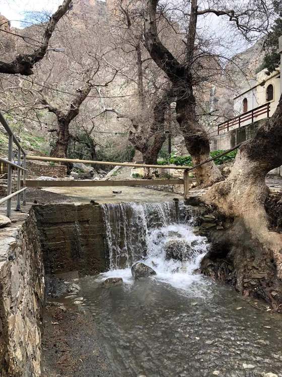
What is the beach at Maridaki like?
The beach at Maridaki mixes pebbles and grey sand at the gorge mouth. Cold spring water runs across it into the sea, and the clear, deep water off the shore suits swimming and snorkelling on calm days without wind.
The shore is compact and framed by the ravine. Pebbles and grey sand make up the beach itself. The cold spring water running down the gorge crosses the shingle before it reaches the sea, chilling the shallows where the two meet. The water offshore is clear and deep, dropping away quickly from the pebble line, which is what makes it good for snorkelling as well as swimming. The Crete beaches along this southern coast share that pattern of clear deep water and coarse shingle, a contrast with the long sandy strands of the north.
At Maridaki the gorge, the spring and the sea meet in a single small arc of shore backed by green, one that stays distinct from every other cove on the coast.
The setting shapes the swimming as much as the seabed does. Palm trees and oleander crowd the back of the beach, giving patches of shade that the open coves nearby lack. The fresh water keeps the immediate surroundings green through the dry months. The Libyan Sea here faces open water, so conditions swing with the weather, and calm days give the clearest swimming and the best visibility for snorkelling. The absence of any resort development means no sunbeds, no water sports and no crowds, only the pebbles, the spring, the taverna in season and the sea. Travellers who reach the shore find the swimming and quiet, not facilities, are the point of the visit.
The walk in filters out day-trippers and leaves the small beach to those who make the effort.
How hard is the drive to reach Maridaki in Crete?
Reaching Maridaki in Crete means a long, rough mountain drive across the Asterousia range, followed by a short walk down the gorge. The difficult approach is what keeps the hamlet quiet and free of resort development.
The drive is the barrier that defines the visit. A long, rough mountain road crosses the Asterousia range from the Messara plain and winds down toward the coast, ending above the hamlet where the gorge path takes over. The surface and the gradient make this a slow journey rather than a quick coastal hop, and the effort filters out casual traffic before it ever reaches the shore. That difficulty is precisely why Maridaki stays quiet and free of development. The same isolated character defines the neighbouring mountain settlement of Kapetaniana, which stands high on the southern side of the Asterousia at the end of its own winding road above the sea.
Both places sit at the wild end of their respective roads, screened by the same range.
The road repays the effort with solitude rather than convenience. There is no direct route along the coast linking Maridaki to the next cove, so each remote beach on this shore is reached by its own descent from the mountains. The isolation this creates means deep quiet, clear swimming and a wild gorge walk with almost no one else about. Travellers planning to stay in the region rather than day-trip from the north can weigh options in the guide to where to stay in Crete. The drive from the north coast runs long enough that an overnight base in the south makes the journey worthwhile.
The rough approach is the price of the quiet that follows, and it repays the difficult drive with solitude at the water’s edge.
What lies near Maridaki along Crete’s south coast?
Near Maridaki lie other hidden Asterousia coves reached only on foot or by boat. These beaches sit well beyond the resorts, strung along the wild southern edge of Crete below the Asterousia mountain range and its gorges.
The hamlet is one link in a chain of remote coves. Along this stretch of the Asterousia coast, small beaches sit at the foot of gorges and cliffs. Reaching them means walking in or arriving by boat rather than driving to a car park. The lack of a coastal road joining them keeps each one separate and quiet, and Maridaki holds its place among them as a green, spring-fed pocket rather than a bare shingle bank. This southern belt sits well beyond the reach of the resorts on the north coast. It draws travellers after deep quiet and clear water instead of facilities and crowds along the shore.
The gorges that feed each cove give the coast its broken, green-and-grey character between the mountains and the sea.
Access by sea opens the coves that feet cannot easily link. Small boats connect certain southern beaches in calm weather, so a swimmer or walker who reaches one shore can sometimes move along the coast by water to the next. This is the pattern of the whole southern edge below the Asterousia: mountain barrier behind, open Libyan Sea in front, and a string of isolated shores between them. Maridaki rewards the difficult drive and the gorge walk with solitude, clear swimming and a wild ravine at the southern edge of the island. It stands as a base for reaching the harder coves that share this stretch of coast.
The chain runs on, cove after cove, each one screened by its own gorge and its own long descent from the hills.
Frequently Asked Questions
Is there a taverna at Maridaki?
Maridaki has a seasonal taverna at the mouth of the gorge, among the scatter of houses at the foot of the walk down the ravine. It operates in season rather than year-round, so food and shade at the shore depend on the time of the visit. Off-season travellers reach an empty beach with no service, which suits those after complete quiet but means carrying in water and supplies for the day. The taverna, the spring water and the pebble shore are the whole of what waits at the bottom of the gorge, with no shops or resort facilities beyond them.
The walk-in access and the seasonal opening keep numbers low even through the height of summer on this southern shore. The taverna sits within reach of the beach, so a swim and a meal fit into a single visit when it is open. The green setting of palm trees and running water shades the tables through the hottest part of the day.
Can you swim and snorkel at Maridaki?
The water at Maridaki is clear and deep, which makes it good for both swimming and snorkelling on calm days. The seabed drops away quickly from the pebble line at the gorge mouth, giving depth close to shore and clear visibility for anyone looking beneath the surface. Cold spring water runs across the beach into the sea, chilling the shallows where the fresh water meets the salt, so the immediate edge feels colder than the open water. The Libyan Sea here faces open water, and conditions change with the weather, so the clearest swimming comes on settled days without wind or swell.
The absence of resort development means no lifeguards and no rented equipment, so snorkellers bring their own gear and judge the sea themselves. The coarse shingle and the clear deep water place Maridaki firmly among the string of southern swimming coves below the Asterousia range. The pebble shore stays free of the crowds that fill the north-coast beaches through summer.
How does Maridaki fit into a wider Crete trip?
Maridaki works as a remote day out or an add-on to time spent exploring the south coast, rather than a base in itself. The long mountain drive across the Asterousia range makes it a poor choice for a quick stop, so it rewards travellers who set aside the time and pair it with other hidden coves along the same shore. The whole southern belt below the Asterousia mountains forms a network of walk-in and boat-reached beaches, and Maridaki sits among them as a green, spring-fed pocket at a gorge mouth. Planning a route across the island helps here, since the drive down from the north coast runs long and slow.
Reading a map of the region alongside the plan shows how Maridaki and its neighbours reward the effort of reaching the far southern edge of the island. The pebble beach, the spring and the ravine make the difficult approach worthwhile for travellers after quiet swimming and a wild walk down to the sea.