
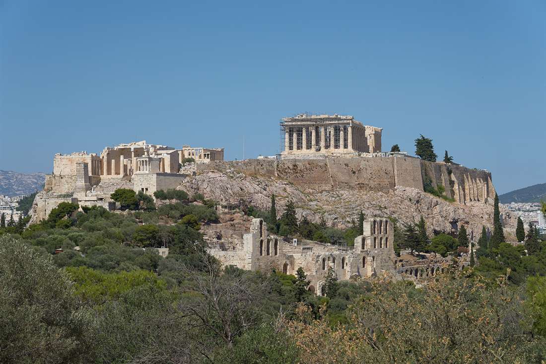
Free views of the Acropolis start on the Areopagus, the hill nearest the entrance, and reach as far as Mount Lycabettus, which rises 277 metres above the city. Between those two sit Filopappos Hill, the Pnyx and Strefi Hill, and each one frames the rock from a different direction.
Dionysiou Areopagitou Street and Monastiraki Square show the rock from below, and a walking route of six stops links them in one afternoon. Anyone planning more than Athens can browse every region we cover on the Greece Tours homepage.
Where can you find free views of the Acropolis?
Five kinds of place give free views of the Acropolis. They are hills, pedestrian streets, squares, the edge of the old town and the night view. Each one is a spot on public ground with no entry fee.
The Wikipedia article on the Acropolis states that the rock rises 150 metres above sea level. Its flattish top covers about 3 hectares. That makes the rock a small, high platform you can read from the ground around it. Free views of the Acropolis start at street level, with no climb to the summit.
Each kind of spot has one fact to hold on to. Mount Lycabettus stands 277 metres high, and Wikipedia calls it the highest point in central Athens. Dionysiou Areopagitou Street is a pedestrian street beside the south slope. Monastiraki Square has a metro station for Line 1 and Line 3.
The edge of the old town is the fourth kind. The National Observatory stands on the Hill of the Nymphs in Thiseio, opposite the Acropolis, according to Wikipedia. The night view is the fifth kind. The Wikipedia article on the Acropolis opens with a photograph of the rock at night.
Distance changes what you see. A photograph from Mount Lycabettus on Wikipedia shows the Hill of the Nymphs on the right of the rock. Philopappos Hill sits on the left, close behind it. Free views of the Acropolis from far away show the rock inside the city.
The closest spot is the Areopagus. Per a travel blog, the rock stands very near the main gate. The farthest hill on this page is Lycabettus, which stands 127 metres higher than the rock. That is the plain difference between 277 metres and 150 metres.
A view from outside shows the outside of the temple only. Wikipedia describes the Parthenon as a peripteral temple, which means columns run around the whole building. The two-chambered cella sits inside that ring. So free views of the Acropolis show the columns, the gable ends and the rock walls. The rooms stay out of sight.
Which hills give free views of the Acropolis?
Five hills give free views of the Acropolis: the Areopagus, the Pnyx, Filopappos Hill, Strefi Hill and Mount Lycabettus. The Areopagus stands closest to the entrance, and Lycabettus stands highest at 277 metres.
Wikipedia places the Areopagus northwest of the Acropolis. A travel site puts it just to the right of the exit of the Acropolis. The rock is also called Areopagus Hill, and it gives free views of the Acropolis from the northwest. From it you look over the Agora below and the Temple of Hephaestus, a travel blog states.
The same travel site states that the Areopagus is always open and has no admission fee. It adds that the rock has been worn to a shiny, slippery surface. Shoes with a good grip matter here. Daylight is the recommended time for this spot.
The Pnyx is next. Wikipedia puts it less than 1 kilometre west of the Acropolis. It is a small rocky hill in parkland, with steps cut into the slope. The parkland is fenced, but Wikipedia states you can visit it free of charge at any time.
One caption on the Wikipedia article about the Acropolis describes a photograph taken from the Pnyx. It names the west facade of the Parthenon. So free views of the Acropolis from the Pnyx show the temple from the west. The hill slope sits in the foreground.
Filopappos Hill is the third hill. Wikipedia locates the tomb of Philopappos on Mouseion Hill, southwest of the rock itself. A travel site gives the hill a height of 147 metres. The rock stands at 150 metres, so the two summits differ by 3 metres. A tour operator blog calls the result a face-to-face view.
The travel site says free views of the Acropolis from the hill face north. It lists entrances on Arakinthou, Panetoliou and Mousseion streets. The hill is always open, with no admission fee. A travel blog gives the walk to the hill from the Areopagus or the Acropolis gate as about 15 minutes.
The monument is the usual stop. Wikipedia gives its size as 9.80 by 9.30 metres, in white Pentelic marble. The travel blog names it the popular viewpoint on the hill. Other trails give a slightly different angle on the rock. Free views of the Acropolis here change with each path.
Lycabettus is the distant view. Wikipedia gives a height of 277 metres. That is 127 metres above the rock. The hill website says its strongest view faces the Acropolis and Piraeus. Free views of the Acropolis from the summit show the rock in the middle of the city.
A paved trail with switchbacks runs to the summit. A travel blog puts the walk at about 15 minutes and lists the cost as free. The trail is the no-fee way up. The closest metro stops are Panepistimio and Evangelismos, the blog states. Wikipedia also describes a funicular from Aristippou Street in Kolonaki, with a journey time of 3 minutes.
Strefi Hill is the second distant view. Wikipedia calls it a limestone hill and urban park, about 150 metres above sea level. That matches the height of the rock. The hill lies northwest of Lycabettus, on the border of Neapoli and Exarcheia. Its terraces give free views of the Acropolis, the city and Lycabettus.
The hills sit around the rock like points on a clock face. Wikipedia places the Areopagus northwest of the Acropolis, the Pnyx to the west and Filopappos Hill to the southwest. Lycabettus and Strefi stand farther out. Free views of the Acropolis therefore change with the side you choose, not only with the distance.
Opening times are simple. The travel site states that the Areopagus and Filopappos Hill are always open, and it recommends daylight for both. Wikipedia states that the Pnyx parkland can be visited at any time. Plan free views of the Acropolis around daylight first.
Pick by the walk you want. The Areopagus has the shortest walk from the entrance. Filopappos Hill gives a view at nearly the height of the rock. Lycabettus gives the highest view. The Pnyx and Filopappos Hill need no fee.
Which streets and squares give free views of the Acropolis?
Dionysiou Areopagitou Street gives the closest street-level free views of the Acropolis. It runs along the south slope. On its north side the archaeological site replaces the buildings, so the rock rises straight above the pavement.
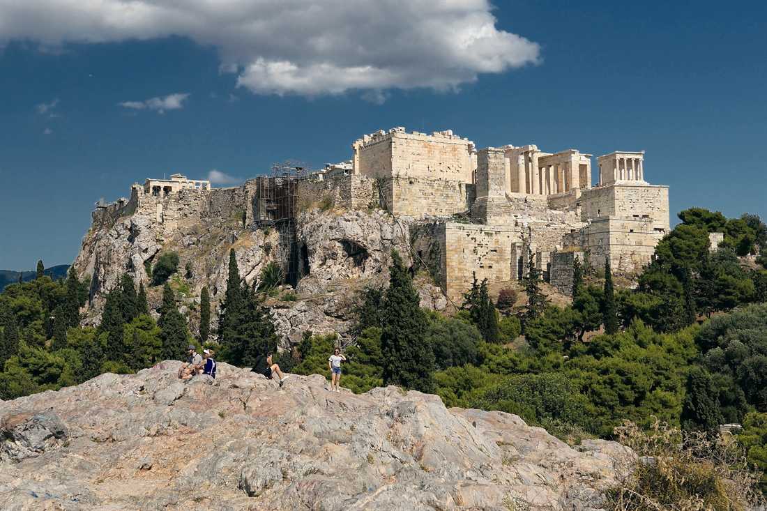
Wikipedia’s article on the street calls it a pedestrian zone. It runs from east to west. Its east end meets Amalias Avenue beside the Arch of Hadrian, and its west end reaches Philopappos Hill. Buildings stand on the south side only.
That layout gives this street the longest run of free views of the Acropolis at pavement level.
The entrance to the Theatre of Dionysus sits near Makrygianni Street, the same article states. The entrance to the Odeon of Herodes Atticus sits near the western end. Both lie on the slope you are looking at. You need no ticket to walk past them and see the southern wall of the rock.
Wikipedia’s article on the Acropolis gives the rock a height of 150 metres above sea level. Its top covers about 3 hectares. The street sits at its foot on the south side, so the whole wall stands above you.
Apostolou Pavlou Street carries the pedestrian zone on toward Thiseio. Wikipedia’s article on Thiseio says the two streets meet. Together they form the main pedestrian zone around the Agora site, from Thiseio to the Acropolis.
The article lists shops, restaurants and cafés along it, so you can stop between views. This stretch adds a second route for the view, away from the traffic.
Monastiraki Square is the next stop. Wikipedia’s article on the district names the Church of the Pantanassa inside the square. It gives Pandrossou and Adrianou as the main streets. The metro station stands on the square. Two lines, 1 and 3, stop there.
The coordinates in that article put the square north of the rock, so you look south. A photo in the gallery shows the Tsisdarakis Mosque with the Acropolis behind it. Free views of the Acropolis start here as you step off the platform.
Ermou Street is 1.5 kilometres long. It links Kerameikos with Syntagma Square through Monastiraki, Psiri and Thiseio. Wikipedia’s article states that its western section was remodelled as the end of the Grand Promenade. That promenade is the pedestrian walkway around the Acropolis. Walk the western section and the rock stays close.
Ermou makes one of the easier free views of the Acropolis to reach from the shops.
Plaka gives the nearest view from the old town. Wikipedia’s article says it hugs the north and east slopes of the hill. Adrianou Street divides it into Ano Plaka, right under the rock, and Kato Plaka, between Syntagma and Monastiraki. Our guide to Plaka covers the lanes one by one.
The upper lanes keep the free views of the Acropolis in the gaps between the roofs. Wikipedia’s article adds that Plaka is the only neighbourhood in Athens where all utilities lie underground. The district also sits under strict zoning and conservation rules.
Anafiotika is a small part of Plaka, set on the north-east flank of the hill. The first houses went up for builders from the island of Anafi, Wikipedia’s article on the district states. White cubic walls and bougainvillea give it a Cycladic look. The article counts 45 houses left.
Its small streets end at ladders, dead ends or terraces where a visitor can sit. The rock stands directly above those terraces, which makes them quiet spots for free views of the Acropolis.
Amalias Avenue is the last street on this list. Wikipedia’s article on the avenue puts the Arch of Hadrian and the Temple of Olympian Zeus to the south. The arch is 18 metres high. Its inscription on the northwest side faces the Acropolis, the article on the arch states.
The temple stands about 500 metres south-east of the Acropolis, and 16 of its columns remain. A photo in the article on the arch shows the Acropolis in the background. Stand at the arch for free views of the Acropolis with Roman stone in front.
Which free views of the Acropolis work at night?
Free views of the Acropolis at night start where floodlights meet open streets. Thiseio, the Anafiotika terraces and the Areopagus all carry night views in Wikipedia’s articles. The Parthenon stays lit above them.
A news report on the lighting states that an LED system lights the ancient temples on the rock. The Parthenon is among them. The same report calls the system lower in energy use. It says the fixtures are meant to reduce light pollution. The lights came on at an evening ceremony in late September.
A second news report counts 51 concentrated light rays on the marble structures. That is a large number of beams for one rock. Each adds to the free views of the Acropolis once the sun is down. It explains why the Parthenon reads as a pale block from far across the city.
Thiseio is the street-level choice. Wikipedia’s article on the area calls it known for pedestrian streets, Acropolis views, cafés and open terraces. The article carries a night photo of the Parthenon in its section on the area. Free views of the Acropolis at night suit this district, because Apostolou Pavlou leads straight into it.
Anafiotika has a night view of its own. Wikipedia’s article states that its streets end at terraces. A visitor can sit there and enjoy the night view of the city. The article puts the district right beside the rock. Come here after Plaka has emptied.
Monastiraki Square stays in play for free views of the Acropolis after dark. Its metro station sits on the square, so the walk back is short. The square lies north of the rock. The lit Parthenon stands to the south as you leave the platform.
Hills are a different case. Travel guides describe Philopappos Hill as open at any hour. They note limited lighting there at night. Guides disagree on the Areopagus. One lists 8:00 to sunset, while others call it open all day and night. The ministry’s schedule settles it on the day you go.
Free views of the Acropolis at night from a hill need a torch and good shoes. Wikipedia also holds a night photo of Athens taken from the Areopagus. A street such as Dionysiou Areopagitou is the safer choice if the path looks dark. It keeps the same view.
Getting home is simple. The metro operator’s news page states that the metro runs until 2:00 am on Friday and Saturday. Wikipedia’s articles on the lines list Monastiraki on Lines 1 and 3. They list Thissio on Line 1 and Akropoli on Line 2. Our Athens metro guide maps the lines in full.
Which edges of the old town give free views of the Acropolis?
The north-west and south edges of the old town give free views of the Acropolis. Thiseio and Kerameikos lie north-west of the rock, and Gazi sits beside Kerameikos. Makrygianni lies on the south side, next to the Acropolis metro station.
Thiseio is a traditional neighbourhood of the old city, north-west of the Acropolis. The Wikipedia article on Thiseio lists pedestrian streets and Acropolis views among its features. Standing in Thiseio, you look to the south-east. Free views of the Acropolis from here show the western end of the rock, where the Propylaea stands.
Thiseio station is one of the oldest stations on Line 1 of the Athens metro. It serves free views of the Acropolis on this edge. The Temple of Hephaestus gave the area its name. Wikipedia puts the temple on top of the Agoraios Kolonos hill, in the north-west corner of the Agora. It calls the temple well preserved.
Wikipedia puts the Ancient Agora to the north-west of the rock. The Areopagus bounds it on the south. The hill of Agoraios Kolonos bounds it on the west.
Hadrian Street, spelled Adrianou Street in local usage, carries the address of the Stoa of Attalos. The street runs from Thiseio Square to Chairefontos Street. Its western section is pedestrian. You stay on the street side and do not enter the Ancient Agora. Free views of the Acropolis from this street need no ticket.
Kerameikos lies north-west of the Acropolis. It spreads on both sides of the Dipylon Gate and beside the Eridanos river. Ancient potters worked here, and the ground also served as a major cemetery. The Sacred Way to Eleusis began here.
From Kerameikos the rock lies to the south-east. This is one of the quieter free views of the Acropolis on the edge of the old town. The Panathenaic Way also began here and ran toward the rock, says the Wikipedia article on Kerameikos.
Gazi is built around the former gas factory, today the Technopolis cultural centre. Wikipedia describes the Technopolis as next to Kerameikos and very close to the Acropolis. Its grounds cover about 30,000 square metres. Eight of its buildings carry the names of Greek poets.
Kerameikos metro station on Line 3 stands next to the Technopolis. It serves free views of the Acropolis from the Gazi side. The coordinates in the Gazi article put the rock to the south-east of the district.
Psyri is one of the oldest quarters of Athens. Heroes Square is its central square. The streets that lead into it are named after fighters in the Greek War of Independence. The coordinates in the Psyri article put the Acropolis almost due south. The rock stands ahead as you walk south out of the quarter.
For the southern edge, Makrygianni offers free views of the Acropolis. The district lies on the south side of the rock, between Dionysiou Areopagitou and Syngrou Avenue. Wikipedia gives the distance from the Parthenon to the Acropolis Museum, on the southern slope, as 280 metres. The district takes its name from a general of the Greek War of Independence.
The Acropolis metro station sits under Makrygianni Street, east of the museum. It has three ground-level entrances. Two of them open on the museum’s east wall. The station has three underground levels. Free views of the Acropolis in this district face north, up the southern slope.
Which side of the rock do free views of the Acropolis show?
Each side of the rock shows a different part of the monument. The west shows the Propylaea gate. The south shows the theatre slope. The north shows the caves above Plaka, and the east shows the Parthenon’s east front. Your compass point decides what you see.
The west end holds the Propylaea, the monumental gate of the Acropolis. Wikipedia says the only easily accessible path onto the plateau runs between two spots. They are the bastion of the Temple of Athena Nike and the terrace of the Agrippa Monument.
Free views of the Acropolis from the west show that bastion and the gate behind it. The Temple of Athena Nike is the smallest temple on the rock. The Propylaea itself carries no sculpture on its metopes or pediments.
The Parthenon shows a short end from the west and a long flank from the north or south. The frieze carries 14 metopes on each of the east and west sides. It carries 32 metopes on each of the north and south sides.
On the south side, free views of the Acropolis cover a slope with three structures in a row. They are the Theatre of Dionysus, the Stoa of Eumenes and the Odeon of Herodes Atticus. Wikipedia places the stoa between the theatre and the odeon. The odeon stands on the south-west slope. It was built in AD 161 and has a capacity of 5,000.
Above the south slope, the Erechtheion has a porch with six sculpted female figures. Wikipedia says they all face south. The same article records that Cimon and Themistocles ordered the southern and northern walls rebuilt after 468 BC.
From the south you see a wall, a slope of theatres and a row of figures facing you. That is what free views of the Acropolis show on this side.
Plaka clusters around the northern and eastern slopes of the rock, says Wikipedia. The Erechtheion stands on the mid-north part of the summit. Two caves lie on the north slope. One was dedicated to Pan.
A second cave beside it held a sanctuary of Apollo from the Julio-Claudian period. Mycenaean builders also cut two steep, narrow flights of steps into the north side. Free views of the Acropolis from the Plaka lanes look up at this rough, cave-marked face.
The east end holds the Parthenon’s east front. At this end, free views of the Acropolis look at a temple front with a carved pediment. The east pediment showed the birth of Athena, according to Wikipedia. The entrance of the Erechtheion also faces east, behind six Ionic columns. A vantage point east of the rock faces this end.
Light changes the look of each side. A Wikipedia caption records a sunset over the Hill of the Nymphs, photographed from the Propylaea. So evening light reaches the western end.
The article on Athens also shows a sunrise photographed from the Areopagus, with Mount Lycabettus in the picture. Morning light therefore reaches the rock from the opposite side. The east end gets it first. That is why free views of the Acropolis from the east and the west look so different in one day.
- Thiseio and Hadrian Street: the west end of the rock first.
- Kerameikos and Gazi: the west and north-west side, looking south-east.
- Makrygianni: the south slope, looking north.
- Psyri: the rock straight ahead to the south.
Pick the side that matches the hour. West-end views suit the evening, and east-end views suit the morning. These free views of the Acropolis cost nothing, so you can return at both hours.
How do you walk a route of free views of the Acropolis?
A route of free views of the Acropolis fits six stops: two stations, two streets, one rock and one hill. The last stop falls at dusk. Each stop shows the rock from a new side.
Start with the metro. Wikipedia’s article on Monastiraki station says it joins Lines 1 and 3 and sits right beneath the Acropolis. Thiseio is the next station on Line 1, so the first two stops cost almost no walking.
- Stop 1, Monastiraki station: Wikipedia places the station beside the Ancient Agora site.
- Stop 2, Thiseio: Wikipedia calls it an old-city neighbourhood northwest of the Acropolis, with pedestrian streets and views of the rock. The name comes from the Temple of Hephaestus, once mistaken for a temple of Theseus.
- Stop 3, Apostolou Pavlou Avenue: Wikipedia describes this pedestrian zone as the one that goes around the archaeological site of the Acropolis and the Agora.
- Stop 4, the Areopagus: the city’s official visitor guide puts this rock about 300 metres west of the Acropolis.
- Stop 5, Dionysiou Areopagitou Street: it runs east to west along the south slope, from Amalias Avenue to Philopappos Hill, says Wikipedia.
- Stop 6, Filopappos Hill at dusk: a travel blog gives about 15 minutes on foot from the Areopagus or from the main entrance.
Wikipedia’s article on Dionysiou Areopagitou Street explains why stop 5 stays open to the view. After Makrygianni Street, buildings stop on the north side and the archaeological site takes their place. The Theatre of Dionysus entrance lies near that corner. The Odeon of Herodes Atticus entrance lies near the far end.
The footpaths of the Acropolis landscaping are one more link. Wikipedia says they give access to the Odeon of Herodes Atticus, the Acropolis and Philopappos Hill.
Dusk suits the last stop. A walking-tour operator’s page says the hour before sunset turns the marble gold. It adds that Filopappos stands at roughly the same height as the rock, so the view is face to face.
Plan the way out as well. Acropolis station, on Line 2, lies south of Dionysiou Areopagitou Street and east of the Acropolis Museum, Wikipedia states. Syntagma is the next station on that line. The walk back along the street ends this route at a platform.
Short on time? Drop stops 1 to 3. Stops 4 to 6 still give three free views of the Acropolis. One comes from a rock, one from a street and one from a hill. Add the first three stops when you want the view from the north-west side too.
What do free views of the Acropolis not show?
Free views of the Acropolis show the outside of the rock and its monuments. They do not show the Parthenon’s inner room or the Porch of the Maidens at close range. They also miss the summit panorama and the sculptures now held in museums.
The inner room stays out of sight. Wikipedia gives the Parthenon’s cella as 29.8 by 19.2 metres and says it held the statue of Athena Parthenos. That statue is lost and known only from copies.
The Porch of the Maidens is a second limit. Wikipedia’s article on the Erechtheion describes six female figures that serve as supports and face south. Replicas stand there now. The originals are in the Acropolis Museum, and one is in the British Museum.
Wikipedia also says only a small number of Parthenon sculptures remain in place. A large number are in the Acropolis Museum and the British Museum. Wikipedia names the Louvre and the National Museum of Denmark as homes of further pieces. It adds that agents of a British earl removed about half of the surviving sculptures. The east pediment once held 10 to 12 figures of the Birth of Athena, and a large number were lost.
The top is the third limit. Wikipedia describes a flattish-topped rock with a surface of about 3 hectares. The Propylaea form the gate. The small Temple of Athena Nike stands south of it. The Parthenon sits at the centre. The Erechtheum lies east of the gate and north of the Parthenon. Free views of the Acropolis show these from below, never from among them.
The summit panorama is the fourth limit. A travel blog lists what a visitor sees from the top. The list holds the Odeon of Herodes Atticus, the Areopagus, the Theatre of Dionysus and the Temple of Olympian Zeus. A walking-tour operator makes the opposite point: on the rock you cannot see the rock.
When the inside matters, a ticket is the next step. Our Acropolis tickets guide covers the booking steps.
What do travellers ask about free views of the Acropolis?
Do free views of the Acropolis need a ticket?
No. A walking-tour operator’s page says its listed viewpoints need no ticket, no reservation and no time slot. A travel blog marks both the Areopagus and Filopappos Hill as free. The ticketed site starts at the entrance gate.
Which spot is nearest for free views of the Acropolis?
The Areopagus. A walking-tour operator’s page describes it as a rocky outcrop just below the Acropolis entrance. A second source calls the climb free. From this rock the Acropolis fills the view at short range.
Which hill gives the highest free views of the Acropolis?
Lycabettus. Wikipedia gives its summit as 277 metres above sea level, the highest point in central Athens. The same encyclopedia puts the rock itself at 150 metres. Filopappos offers a view from about the rock’s own height, says the operator.
When are free views of the Acropolis least crowded?
At sunrise. A walking-tour operator’s page says sunrise brings warm light on the eastern face and empty trails. It also says the Areopagus can be crowded at sunset.
Which season suits free views of the Acropolis?
Spring. The same operator names the stretch from March to late spring. It cites wildflowers on the hillsides and temperatures in the low twenties. For summer, it advises an early start.
What do you wear for free views of the Acropolis?
Proper shoes. A walking-tour operator’s page says the trails on Filopappos and Lycabettus are uneven and rocky. It adds that the rock can be slippery. It also states that no vendors work on the trails, so you bring water.