
Apano Kastro is a ruined hilltop fortress standing on a rocky peak in the Tragaea valley of central Naxos, above the village of Tsikalario. The name means Upper Castle, and the Venetian dukes of the Aegean built it as an inland refuge on far older foundations. Cyclopean walls, cisterns, chapels and commanding views survive on the summit, reached by a marked path that climbs through granite outcrops and terraced fields. This monument rewards travellers who want history and a short mountain walk in one visit. Explore the fortress, the route up and the panorama across the Naxian interior with My Greece Tours.
Apano Kastro sits at the geographic heart of Naxos, midway between the mountain villages and the coast. Our Naxos travel guide places the fortress within a network of Byzantine chapels, towers and footpaths that thread the Tragaea. The sections below cover what Apano Kastro is and its long history, how the walk climbs up from Tsikalario, the ruins and chapels crowning the summit, the panorama over central Naxos, and the practical steps for reaching the site on foot.
What is Apano Kastro and why does it matter?
Apano Kastro is a ruined Byzantine and Venetian fortress on a granite peak above Tsikalario in the Tragaea valley. It served as the inland refuge and administrative stronghold of the Venetian dukes who ruled medieval Naxos.
The fortress crowns a steep rock roughly 500 metres above sea level, dominating the central plain of Naxos. Its Greek name, Apano Kastro, translates as the Upper Castle, distinguishing it from the coastal capital. The Venetian rulers raised the medieval walls on foundations far older than their duchy, reusing cyclopean masonry from an ancient acropolis. The site controlled the routes between the fertile Tragaea and the mountain settlements. Defenders could watch every approach across the valley from this height. The fortress mattered because it gave the dukes a secure retreat away from the vulnerable shoreline. Pirate raids and rival lords threatened the coast, so an inland citadel guaranteed survival.
The layered walls, chapels and cisterns you see today record centuries of Naxian defence compressed onto one commanding summit.
The history of the rock stretches back long before the medieval period. Archaeologists connect the earliest walls with a fortified settlement of remote antiquity, evidenced by the massive unworked blocks along the lower defences. The Byzantine period added chapels and reinforced the perimeter, folding the peak into the Christian landscape of the island. Read the wider story in our history of Naxos, which traces the same succession of rulers across the whole island. The Venetian Sanudo dynasty, founders of the Duchy of the Archipelago, then fortified Apano Kastro as their Tragaea seat. Each era left a distinct mark in the stone.
Walking the ruins, you cross ancient, Byzantine and Venetian construction within a few paces, a rare density of history on a single Aegean hilltop.
How do you walk and climb up from Tsikalario?
The climb starts at Tsikalario, a tiny village below the fortress. A marked footpath winds up through granite boulders, terraces and low scrub, gaining the summit in roughly forty-five minutes to an hour of steady, moderate walking.
The trailhead lies at the edge of Tsikalario, reachable by car from the main Chalki to Filoti road. Park near the village and follow the signs and painted waymarks toward the rock. The path first crosses gentle terraced fields, then steepens as it enters a landscape of rounded granite outcrops. The route is stony and uneven, so sturdy shoes matter more than distance. The ascent covers about 250 metres of height gain over a short horizontal span. Halfway up, the path passes clusters of scattered rock and the odd ruined chapel. The final section scrambles over bare stone to reach the fortified gate.
The walk forms part of the wider network of hiking in Naxos, linking the Tragaea villages by old stone trails.
The best walking conditions fall in spring and autumn, when the Tragaea turns green and temperatures stay mild. Summer ascents demand an early start, plenty of water and a hat, since the granite radiates heat and shade is scarce. The path is not technical, but loose stones reward careful footing on the descent. Carry water for the whole loop, as no spring runs on the summit. The village of Filoti nearby offers cafes and supplies before you set out. Many walkers combine the fortress with a longer day among the Byzantine churches of the valley. The reward for the short effort is immediate at the top.
Every metre climbed opens a wider view over the plain, and the ruined walls appear suddenly above the last outcrops of granite.
What ruins and chapels stand on the summit?
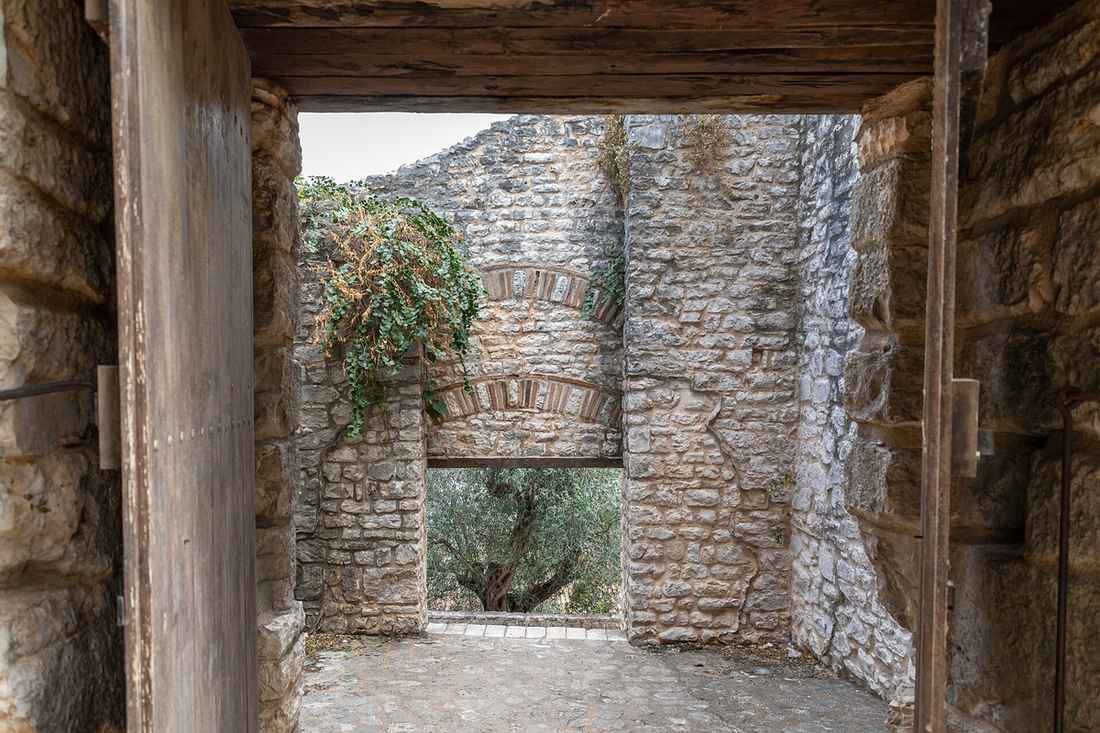
The summit holds ruined defensive walls, several rock-cut cisterns and small whitewashed chapels. Cyclopean blocks form the oldest circuit, while Byzantine and Venetian masonry raised the medieval towers, gate and living quarters across the rocky plateau.
The fortifications ring the natural rock, using the cliff itself as part of the defence. The oldest walls, built of huge unmortared blocks, survive along the lower edges and betray the ancient acropolis beneath the castle. Above them, the Venetian builders added mortared walls, a gatehouse and the footings of towers and dwellings. Cisterns cut into the living stone once stored rainwater for the garrison through the dry Aegean summers. These cavities remain visible, some still holding water after rain. Fragments of houses and storerooms scatter the plateau in low, tumbled courses. The layout follows the contours of the peak rather than a regular plan.
Exploring the enclosure, you trace how successive rulers reused and extended the same defensible ground across many centuries of occupation.
Two small Byzantine chapels stand among the ruins, the most notable dedicated in the medieval Christian tradition of the island. Their simple whitewashed forms contrast with the grey granite and the tumbled defensive stone around them. Faded frescoes cling to the interior walls of the better-preserved chapel, echoing the painted churches that make the Tragaea famous. These sanctuaries served the castle community and the shepherds of the surrounding hills. Their survival on such an exposed summit speaks to the enduring religious life of the interior. The chapels sit within the same tradition as the great fortified quarter of the Kastro in Naxos town, though far smaller and wilder.
Together the walls, cisterns and chapels turn the peak into an open-air record of Naxian history you can walk through freely.
What can you see from the top of Apano Kastro?
The summit commands a full panorama over central Naxos. The Tragaea valley, the villages of Chalki, Filoti and Tsikalario, the surrounding mountains and, on clear days, the distant Aegean sea and neighbouring islands all spread out below the fortress.
The view explains the whole reason the fortress stands here. From the walls, the green bowl of the Tragaea opens directly below, dotted with olive groves, villages and Byzantine church towers. The eye follows the old routes that the castle once controlled, threading between the settlements of the plain. To the south and east rise the island’s highest peaks, a rampart of grey stone above the cultivated land. The bulk of Mount Zas, the tallest summit in the Cyclades, dominates that horizon. The commanding sightlines gave the medieval garrison warning of any force moving through the interior.
This 360-degree survey of the island is the single most memorable reward of the climb, and it costs nothing but the walk up.
On clear mornings the panorama reaches far beyond the island itself. The western view drops toward the coast and the shimmer of the Aegean, with the silhouettes of neighbouring Cyclades floating on the sea. Light shifts the scene through the day, and the low sun of late afternoon rakes the granite and the terraced fields into sharp relief. This is the moment photographers wait for. Bring a camera and time your visit for softer light rather than harsh midday glare. The elevated position also catches the wind, so a layer against the breeze helps even in summer.
Standing where the Venetian dukes once watched their duchy, you grasp why they chose this rock above every other in the interior.
What else can you explore near Apano Kastro?
Apano Kastro pairs with the Byzantine churches, olive groves and stone villages of the Tragaea. The frescoed chapels near Chalki, the necropolis at Tsikalario and the peaks around Filoti fill a rewarding full day in central Naxos.
The Tragaea valley spreads a green mantle of olive groves below the fortress, dotted with some of the oldest churches in the Aegean. Frescoed Byzantine chapels stand among the fields near Chalki, a short drive from the trailhead. These painted interiors record the same medieval centuries that raised the castle walls above. The stone lanes of the surrounding villages of Naxos reward an unhurried wander after the climb. Tsikalario itself holds a Geometric-era necropolis with rare standing stones, reached along the same slope. A day that strings the fortress, the churches and a village taverna together shows the cultivated heart of the island at its richest, far from the beaches and the busy port town on the coast.
The high peaks frame every view from this part of the interior. The bulk of Mount Zas rises to the south, and marked footpaths climb toward its summit for walkers with time and stamina. A car makes the whole loop simple, linking the trailhead with Filoti, Chalki and the frescoed chapels in a single morning and afternoon. Spring and autumn bring the greenest landscape and the mildest walking weather across the valley. Carry water, wear sturdy shoes and start early to beat the midday heat on the exposed rock. This combination of ruined fortress, ancient tombs, painted churches and mountain scenery makes the Tragaea one of the most rewarding regions on Naxos.
Plan your visit and tours through our Naxos travel guide.
Frequently Asked Questions
How long does it take to visit Apano Kastro?
A visit to Apano Kastro takes roughly two to three hours in total from Tsikalario. The climb up the marked path runs about forty-five minutes to an hour at a steady pace, with a similar time for the descent. Allow thirty to sixty minutes on the summit to explore the walls, cisterns and chapels and to enjoy the panorama. Walkers who want to linger over the views, photograph the ruins or picnic on the rock should budget the full three hours. The trail is moderate rather than strenuous, but the stony surface and the height gain slow most people down.
Combining the fortress with the Byzantine churches and the ancient cemetery near Tsikalario turns the outing into a rewarding half-day among the finest scenery of central Naxos. Start early in summer to avoid the midday heat on the exposed granite.
Is Apano Kastro free to enter and are there facilities?
Apano Kastro is an open archaeological site on a remote hilltop, so entry is free and there is no gate, ticket office or fixed opening hours. The trade-off is a complete absence of facilities on the mountain. No water, no toilets, no cafe and no shade await at the trailhead or on the summit, so you must carry everything you need. Bring at least a litre of water per person, sun protection and sturdy walking shoes for the stony path. The nearby villages of Tsikalario, Chalki and Filoti offer cafes, tavernas and shops where you can eat and refill before or after the walk.
There is no signposted visitor centre or information board of any depth at the site itself. The ruins are unfenced, which lets you explore freely, but it also means you should tread carefully around the old walls, cisterns and steep unprotected edges.
How do I get to the Apano Kastro trailhead on Naxos?
The trailhead sits at the village of Tsikalario in the Tragaea valley, in the centre of Naxos. Drive from Naxos town toward Chalki and Filoti on the main inland road, then follow the signed turning to Tsikalario, a short detour off the main route. The drive from the port takes about thirty to forty minutes. Park at the edge of the village, where the marked footpath to the fortress begins. Public buses connect Naxos town with Chalki and Filoti, but the final stretch to Tsikalario is easier with a rental car or taxi, as bus service to the tiny village is limited.
A hire car gives the freedom to combine Apano Kastro with the other sights of the Tragaea in one day. Follow the painted waymarks and signs from the village, and the rock and its crowning ruins stay in view for most of the climb.