
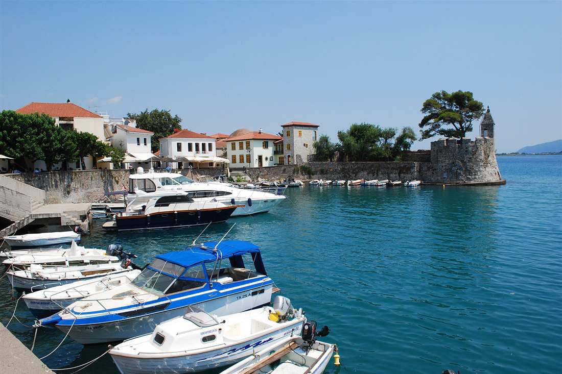
Aetolia-Acarnania tours cover the largest regional unit in Greece: Nafpaktos with its circular Venetian harbour under a castle of five walls, Messolonghi with the Garden of Heroes and the lagoon that carries its salt and bottarga, Lake Trichonida, the Aetolian League sanctuary at Thermos, the ship sheds of Oiniades, the Acheloos delta and the Ionian harbours facing Lefkada. Plan the rest of the trip with Greece Tours.
This page covers the Aetolia-Acarnania tours you can arrange from Nafpaktos, Messolonghi and Agrinio, what each part of the unit holds, the castles and the lagoons, the lakes and the ancient sites, the food of the water and the mountains, and how the bridge, the motorway and the seasons shape the route.
What do Aetolia-Acarnania tours cover?
Aetolia-Acarnania tours cover Nafpaktos with its round Venetian harbour and castle, Messolonghi and its lagoon with the Garden of Heroes, the Acheloos delta, Lake Trichonida, ancient Thermos and Oiniades, the Rio-Antirrio bridge and the beaches of the Ionian coast.
Aetolia-Acarnania is the largest regional unit in Greece, 5,461 square kilometres of mountain, lagoon and river between the Corinthian Gulf and the Ionian. The Acheloos divides the two ancient halves, Aetolia in the east and Acarnania in the west, and the unit carries more fresh water than any other in the country.
- Nafpaktos – the round harbour, the castle on five walls and the Lepanto history.
- Messolonghi – the lagoon, the Garden of Heroes and the Byron memorials.
- Lake Trichonida – the largest natural lake in Greece, under Mount Panaitoliko.
- Thermos – the federal sanctuary and political centre of the Aetolian League.
- Acheloos delta and Oiniades – the wetland, the ship sheds and the ancient theatre.
- Rio-Antirrio bridge – the 2,880 m crossing to the Peloponnese at the gulf mouth.
Our Western Greece tours page covers the wider region. Aetolia-Acarnania tours work as two days from Nafpaktos or as the road between Delphi and the Ionian.
Where is Aetolia-Acarnania, and what is in each part of it?
Aetolia-Acarnania fills the north shore of the Corinthian Gulf and the mainland behind it: Nafpaktos and the Nafpaktia mountains in the east, Messolonghi and Agrinio on the central plain, the lakes of Trichonida and Lysimachia at its heart, and Acarnania with Astakos and Mytikas on the Ionian.
The unit is built round water. The Acheloos, the longest river in Greece at 220 km, runs down its western side into a delta of islands and lagoons; Trichonida and Lysimachia fill the centre; and the Messolonghi and Aitoliko lagoons form the largest wetland system in the country at about 130 square kilometres.
- Nafpaktia – the stone villages and gorges in the mountains north of Nafpaktos.
- Messolonghi and Aitoliko – the lagoons, the salt pans and the fishing platforms.
- Agrinio – the largest town, in the tobacco plain between the lakes.
- Lake Trichonida – 96 square kilometres of fresh water with villages round it.
- Acarnania coast – Astakos, Mytikas and the channel facing Lefkada and Ithaca.
- Amvrakikos shore – the northern wetland border with Epirus.
The unit holds about 210,000 people, most of them in Agrinio and Messolonghi. Aetolia-Acarnania tours drive 40 to 90 km between stops, and the motorway from the Rio bridge reaches Messolonghi in half an hour.
What do Aetolia-Acarnania tours see at Nafpaktos?
Aetolia-Acarnania tours at Nafpaktos see a circular Venetian harbour closed by two towers, a castle of five walled levels climbing the hill above it, the statue of Cervantes who fought at Lepanto, the old town lanes and the pebble beaches on either side of the port.
The harbour is the picture of the town. A ring of stone quay about 60 m across, entered between two towers that once carried a chain, it holds a dozen fishing boats and is lined with cafes built into the wall; the castle behind it runs in five enclosures from the sea to the summit at 220 m.
Off this coast in October 1571 the Holy League destroyed the Ottoman fleet in the battle of Lepanto, the last great galley action in history, and Cervantes lost the use of his left hand in it. His statue stands on the quay, and the castle museum tells the battle from the Venetian side.
- Venetian harbour – the round port with its two towers and the chain gate.
- Castle of Nafpaktos – five walled levels from the harbour to the summit.
- Cervantes statue – the memorial on the quay to the wounded soldier of Lepanto.
- Psani and Gribovo – the pebble beaches west and east of the harbour.
- Botsaris tower – the harbour tower museum of the 1571 battle.
- Nafpaktia villages – Ano Chora, Elatou and the gorges 40 km north.
The walk from the harbour to the top of the castle takes 25 minutes through the walls. Aetolia-Acarnania tours reach Nafpaktos in ten minutes from the Rio bridge and use it as the eastern base.
What do Aetolia-Acarnania tours see at Messolonghi?
Aetolia-Acarnania tours at Messolonghi see the Gate of the Exodus, the Garden of Heroes with the tombs of the defenders and the Byron memorial, the lagoon with its stilt huts and salt pans, the fish tavernas of Tourlida and the museum of the siege.
The town is the shrine of the revolution. Besieged three times, it held out until the night of 10 April 1826, when the surviving population attempted a mass breakout through the Ottoman lines; the Gate of the Exodus marks the point, and the Garden of Heroes behind it holds the graves of the defenders and philhellenes.
Lord Byron died here of fever on 19 April 1824 while training troops for the cause, and his heart is buried in the garden under a memorial. The lagoon beyond the town, the largest in Greece, is worked from wooden huts on stilts and produces salt, eels and the bottarga the town is known for.
- Gate of the Exodus – the breach of 10 April 1826 in the town wall.
- Garden of Heroes – the tombs of the defenders and the Byron memorial.
- The lagoon – stilt huts, salt pans and the causeway to Tourlida.
- Museum of History and Art – the siege paintings and the revolutionary archive.
- Aitoliko – the island town on its lagoon, reached by two stone bridges.
- Bottarga – the pressed grey mullet roe cured in the lagoon since antiquity.
Aitoliko, 10 km north, sits on an island in the middle of its own lagoon and is entered by two long bridges. Aetolia-Acarnania tours take Messolonghi, the causeway and Aitoliko in half a day.
Which ancient sites and lakes do Aetolia-Acarnania tours reach?
Aetolia-Acarnania tours reach Thermos with its temple of Apollo and stoas, Oiniades with its theatre and rock-cut ship sheds, Stratos and its temple of Zeus above the Acheloos, Kalydon of the boar hunt, and the shores of Lake Trichonida and Lake Lysimachia.
Thermos was the capital of the Aetolian League, the federal state that dominated Greece in the 3rd century BC. Its sanctuary of Apollo Thermios holds a long temple of about 620 BC, two stoas, and the ground where the league held its assembly and its annual fair, on a terrace above Lake Trichonida.
Oiniades kept a navy in the marshes of the Acheloos. Its ship sheds are cut into the rock at the old waterline, six bays wide, the best preserved in Greece, and the theatre above them looks over what was once open water and is now farmland.
- Thermos – the Aetolian League sanctuary, temple and stoas above the lake.
- Oiniades – the rock-cut ship sheds, walls and theatre in the Acheloos plain.
- Stratos – the largest city of Acarnania, with its temple of Zeus and walls.
- Kalydon – the sanctuary of Artemis Laphria and the boar hunt of the myth.
- Lake Trichonida – the largest natural lake in Greece, 96 square kilometres.
- Lake Lysimachia – the shallower lake beside it, joined by a channel.
The lakes carry pelicans, herons and cormorants and are ringed by olive and citrus. Aetolia-Acarnania tours drive the Trichonida circuit in two hours with stops at Thermos and the lakeside villages.
Which beaches, wetlands and outdoor trips do Aetolia-Acarnania tours use?
Aetolia-Acarnania tours use the Ionian beaches at Mytikas, Astakos and Palairos, the pebble shores either side of Nafpaktos, the Messolonghi lagoon for birds and boats, the Acheloos and Evinos rivers for rafting, and the Nafpaktia gorges for walking.
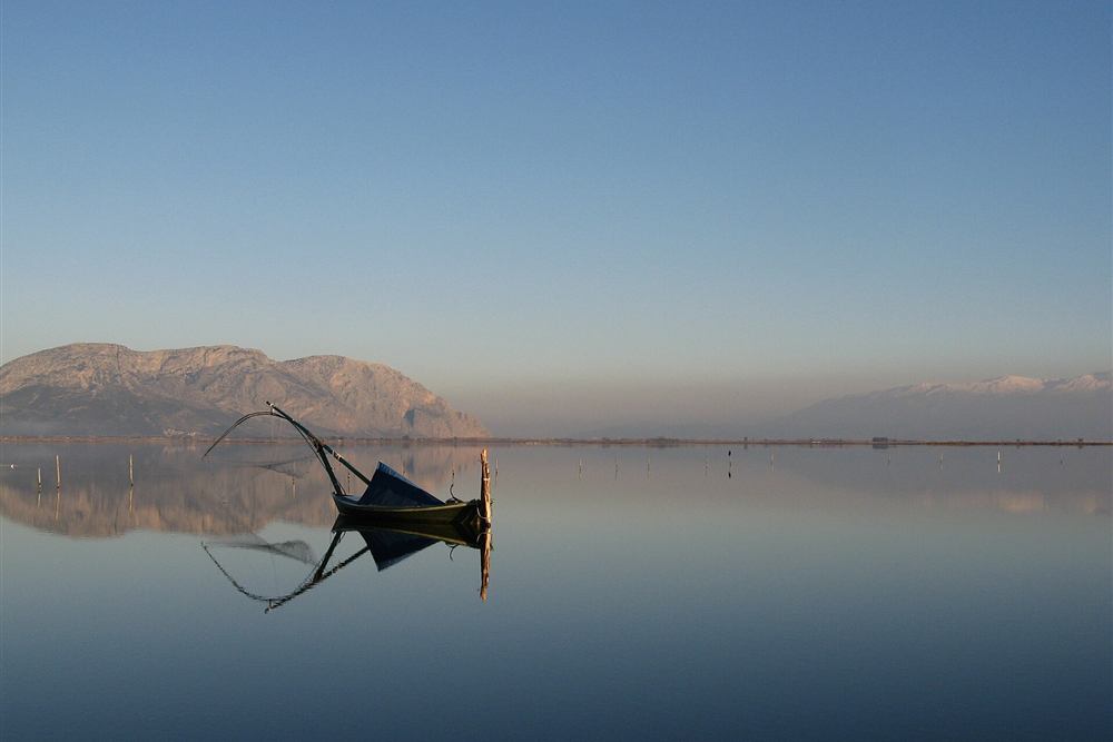
The wetland is the unit’s natural asset. The Messolonghi and Aitoliko lagoons are a Ramsar site holding flamingos, Dalmatian pelicans, glossy ibis and about 280 recorded bird species, crossed by causeways and worked from the stilt huts that stand in the shallow water.
- Messolonghi lagoon – the Ramsar wetland, the hides and the boat trips.
- Mytikas and Palairos – the Ionian harbours facing Lefkada and Kalamos.
- Nafpaktos beaches – Psani and Gribovo, with the castle above them.
- Evinos and Acheloos – the rafting rivers of the eastern and western halves.
- Nafpaktia gorges – the walks at Ano Chora, Platanos and the stone bridges.
- Kalamos and Kastos – the small islands off the Acarnanian coast.
The two islands, Kalamos and Kastos, are reached by ferry from Mytikas in half an hour and hold a few hundred residents between them. Aetolia-Acarnania tours that want the sea use the Ionian side, since the gulf coast is pebble and narrow.
What history do Aetolia-Acarnania tours tell, and how do visitors reach the unit?
Aetolia-Acarnania tours tell of the Aetolian League at Thermos, of the battle of Lepanto off Nafpaktos in 1571, of the three sieges of Messolonghi and the Exodus of 1826, and of Byron’s death in 1824. Visitors reach the unit over the Rio-Antirrio bridge or from Ioannina in two hours.
The Aetolians were the last Greek power to fight Rome as equals. Their league ran a federal state from Thermos with a common assembly, held Delphi for a century, and was broken by Rome in 189 BC, after which the unit slipped out of the record until the revolution made Messolonghi famous.
- Rio-Antirrio bridge – 2,880 m of cable-stayed deck, opened in 2004.
- Athens to Nafpaktos – 215 km, about two and a half hours by Corinth and the bridge.
- Patras to Messolonghi – 50 km, about 40 minutes over the bridge.
- Nafpaktos to Agrinio – 65 km, about an hour through the hills.
- Ioannina to Agrinio – 145 km, about two hours on the Ionia motorway.
- Where to stay – Nafpaktos for the harbour, Messolonghi for the lagoon, Mytikas for the sea.
Spring fills the rivers and the lagoon with birds, autumn brings the olive and the fishing season, and summer works the Ionian beaches with the plain hot inland. Aetolia-Acarnania tours take two days for Nafpaktos and Messolonghi and a third for the lakes and Thermos.
What do Aetolia-Acarnania tours eat and drink?
Aetolia-Acarnania tours eat the bottarga and smoked eel of the Messolonghi lagoon, the salt of its pans, fish from the Ionian at Astakos and Mytikas, the olives and oil of the Amfilochia hills, and drink tsipouro and the wines of the Trichonida slopes.
Bottarga is the unit’s export. Grey mullet roe is taken from the lagoon in autumn, salted, pressed and sealed in beeswax, and the product carries a protected designation; the same waters give eels that are smoked or grilled and sold from the huts on the causeway.
- Messolonghi bottarga – pressed mullet roe sealed in wax, with its own designation.
- Smoked and grilled eel – the lagoon catch, cooked at the Tourlida tavernas.
- Lagoon salt – harvested from the pans between Messolonghi and Aitoliko.
- Ionian fish – the boats at Astakos, Mytikas and Palairos.
- Trichonida wine and tsipouro – the vineyards and stills of the lake villages.
- Nafpaktia meat and pies – the mountain kitchens north of Nafpaktos.
The stilt huts on the Messolonghi causeway sell the catch and cook it at tables over the water. Aetolia-Acarnania tours eat fish on the lagoon and meat in the mountains, which is the split the unit itself makes.
Which villages do Aetolia-Acarnania tours reach in the Nafpaktia mountains?
Aetolia-Acarnania tours reach Ano Chora at 1,100 m with its ski slopes, Elatou and Platanos in the fir forest, Terpsithea above the gulf, Kato Chora with its stone bridge, and the gorge villages of the Evinos and Mornos valleys north of Nafpaktos.
The mountains behind Nafpaktos hold about forty villages between 600 and 1,200 m, rebuilt in stone after the emigration years and reached by a road that climbs 40 km from the coast through the Evinos valley. Ano Chora carries a small ski centre on Mount Sarantena.
- Ano Chora – the highest village at 1,100 m, with the ski slopes above it.
- Elatou and Platanos – the fir-forest villages with guesthouses and squares.
- Terpsithea – the balcony village looking down the Corinthian Gulf.
- Kato Chora – the stone bridge and watermill on the river below.
- Evinos gorge – the river road north from Nafpaktos into the range.
- Mornos reservoir – the eastern border lake that supplies Athens.
The villages fill at Christmas, Easter and in August and stand nearly empty the rest of the year. Aetolia-Acarnania tours drive the Nafpaktia circuit in a day of about 120 km on slow mountain road.
Where do Aetolia-Acarnania tours stay, and what does a three-day route cover?
Aetolia-Acarnania tours stay at Nafpaktos for the harbour and the castle, at Messolonghi for the lagoon, at Mytikas or Palairos for the Ionian, and in the Nafpaktia villages for the mountains. Three days take the east, the lagoon and the lakes in turn.
Nafpaktos holds the widest choice, with hotels round the harbour and along both beaches, and it sits ten minutes from the bridge. Messolonghi has small town hotels, the Ionian harbours have rooms and apartments, and the mountain villages keep stone guesthouses that book out at holidays.
- Day 1 – Nafpaktos harbour and castle, then the Nafpaktia villages.
- Day 2 morning – Messolonghi, the Garden of Heroes and the Gate of the Exodus.
- Day 2 afternoon – the lagoon causeway, Tourlida and Aitoliko.
- Day 3 morning – Lake Trichonida and the sanctuary at Thermos.
- Day 3 afternoon – Oiniades and the Acheloos delta, or the Ionian coast.
- Extra day – Kalamos and Kastos by ferry from Mytikas.
Two days cut the lakes; four add the Ionian islands off the coast. Aetolia-Acarnania tours built this way drive 80 to 130 km a day, and the roads are good except in the mountains.
Which visitors do Aetolia-Acarnania tours suit?
Aetolia-Acarnania tours suit birdwatchers on the lagoons, walkers in the Nafpaktia gorges, sailors crossing to Lefkada and Ithaca, history readers following Lepanto and the Exodus, and drivers using the unit as the link between Delphi, Epirus and the Ionian.
The unit is a crossing rather than a destination for most visitors, which is why its sites stay quiet. The motorway from the Rio bridge to Ioannina runs through it in an hour and a half, and a detour of thirty minutes reaches the lagoon, the castle or the lakes.
- Birdwatchers – the Messolonghi and Aitoliko lagoons and the Acheloos delta.
- Walkers – the Nafpaktia gorges and the paths above Ano Chora.
- Sailors – the Ionian channel between Mytikas, Kalamos and Lefkada.
- History readers – Lepanto, the Exodus of 1826 and the Aetolian League.
- Families – the Nafpaktos beaches with the castle above them.
- Road trips – the link between Delphi, the Peloponnese and Epirus.
What the unit does not have is a resort strip, and its gulf coast is narrow and pebbled. Aetolia-Acarnania tours that want sand cross to the Ionian side at Mytikas and Palairos.
What do Aetolia-Acarnania tours see on the Acheloos and the Amvrakikos shore?
Aetolia-Acarnania tours on the Acheloos see the longest river in Greece running 220 km to a delta of lagoons and islands, the dams and reservoirs of Kastraki and Stratos, the stone bridges of the upper valley, and on the Amvrakikos shore the wetland at Amfilochia and Menidi.
The river carries the unit. It rises in the Pindus, drains a basin of about 6,000 square kilometres, was dammed four times in the 20th century for power and irrigation, and reaches the Ionian in a delta of sandbanks and lagoons that shifts with every flood season.
The Amvrakikos Gulf closes the unit on the north. Its southern shore at Amfilochia and Menidi is shallow, brackish and thick with birds, part of the same protected system as the Epirus side, and the road round it links the unit to Arta and Preveza in an hour.
- Acheloos delta – the lagoons, sandbanks and fishing grounds at the river mouth.
- Kastraki and Stratos dams – the reservoirs on the middle river.
- Amfilochia – the town at the head of the Amvrakikos Gulf.
- Menidi – the shore village on the gulf with the wetland behind it.
- Vonitsa – the Venetian castle town on the southern Amvrakikos coast.
- Lake Ozeros and Amvrakia – the smaller lakes between the river and the plain.
Vonitsa keeps a castle of the 13th century above its harbour and looks across the gulf to Preveza. Aetolia-Acarnania tours take the northern shore on the drive to Epirus, which adds no time to the route.
Frequently Asked Questions
Where is Aetolia-Acarnania?
In Western Greece, on the north shore of the Corinthian Gulf and the mainland behind it, between Phocis in the east, Epirus in the north and the Ionian Sea in the west. Messolonghi is its capital.
How large is the unit?
5,461 square kilometres, the largest regional unit in Greece, holding about 210,000 people, with the Acheloos river dividing ancient Aetolia in the east from Acarnania in the west.
What is at Nafpaktos?
A circular Venetian harbour about 60 m across closed by two towers, a castle of five walled levels climbing to 220 m, the Cervantes statue on the quay and pebble beaches either side of the port.
Why is Messolonghi famous?
For the three sieges of the revolution and the Exodus of 10 April 1826, when the surviving population broke out through the Ottoman lines, and for the death of Lord Byron there on 19 April 1824.
What is the Messolonghi lagoon?
The largest lagoon system in Greece, about 130 square kilometres of shallow water, salt pans and stilt huts, a Ramsar site with roughly 280 recorded bird species and the source of the town bottarga.
What is Thermos?
The federal sanctuary and assembly place of the Aetolian League above Lake Trichonida, with a temple of Apollo of about 620 BC, two long stoas and the ground of the annual fair.
What is Lake Trichonida?
The largest natural lake in Greece, 96 square kilometres of fresh water in the centre of the unit, ringed by a road of about 70 km and joined to Lake Lysimachia by a channel.
Which beaches do the tours use?
The Ionian sands at Mytikas, Astakos and Palairos, the pebble shores of Psani and Gribovo at Nafpaktos, and the small islands of Kalamos and Kastos reached by ferry.
How do you reach the unit?
Over the Rio-Antirrio bridge from Patras in about 20 minutes, from Athens in two and a half hours by Corinth and the bridge, or from Ioannina in two hours on the Ionia motorway.
When is the best time for Aetolia-Acarnania tours?
Spring for the rivers and the lagoon birds, autumn for the olive harvest and the fishing, summer for the Ionian beaches with the plain hot inland, and winter for the mountain villages with snow above 1,000 m.