
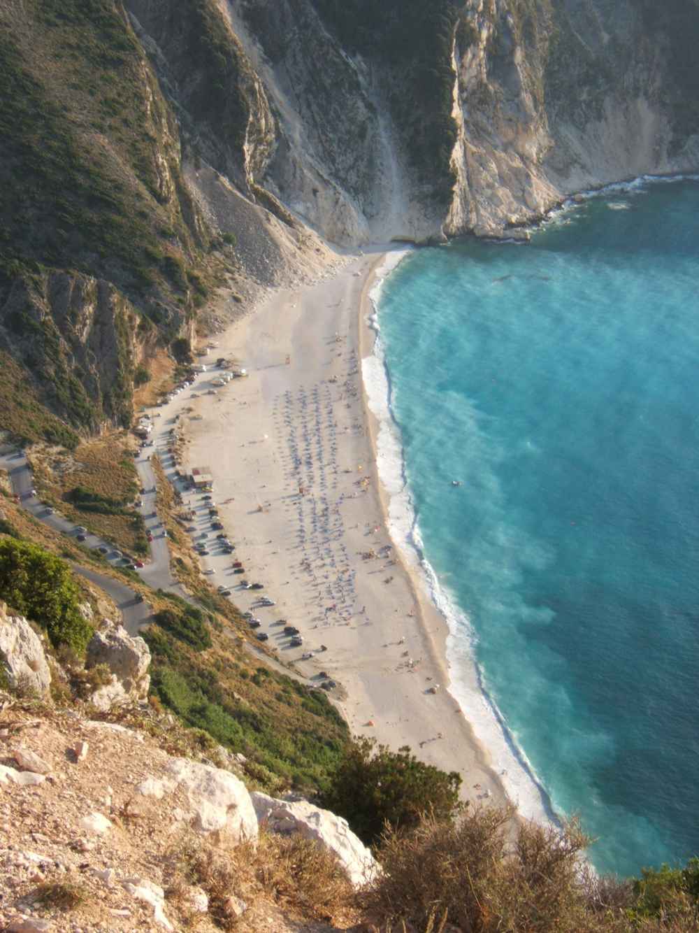
Myrtos beach is the most famous beach of Kefalonia, a broad curve of white pebbles and pale marble sand on the island’s northwest coast. The bay lies between the villages of Assos and Divarata, about 30 km north of Argostoli, the island capital. Steep green-and-white cliffs rise behind the sand, and the water shifts from turquoise near the shore to deep blue offshore. A winding road drops from the main coast road to the beach, and a clifftop viewpoint above frames the classic photograph over the bay. This guide covers the beach, its colour, the viewpoint, the access road and swimming in the deep water. Plan the whole trip with Greece Tours.
The beach faces the open Ionian Sea, so the water deepens quickly and the exposed bay can pick up swell and afternoon wind. Summer brings sunbeds, umbrellas and a canteen to Myrtos, though the beach has no natural shade. Strong swimmers enjoy the clear, deep water; families keep children in the narrow shallows at the pebble edge and watch the afternoon breeze. The nearest large town is Argostoli, about 30 km south, and the airport lies about 9 km beyond it. Myrtos sits on the northwest loop that links the castle village of Assos and the harbour of Fiskardo, a short drive north along the coast.
What is Myrtos beach and where does it sit on Kefalonia?
Myrtos beach lies on the northwest coast of Kefalonia, between the villages of Assos and Divarata, about 30 km from Argostoli. The broad curve of white pebbles sits below steep cliffs on the Ionian Sea.
Myrtos beach forms a broad curve on the northwest coast of Kefalonia, the largest of the Ionian Islands. The beach sits between two villages: Assos to the north and Divarata on the ridge above. Divarata stands on the main coast road, and a side road drops from there to the shore. The nearest large town is Argostoli, the island capital, about 30 km to the south. Sami, the east-coast port, lies farther away across the mountainous interior. The beach faces west, so it holds afternoon and evening light across the water. Visitors reach Kefalonia by air through Kefalonia Airport, about 9 km south of Argostoli, or by ferry from Kyllini and Patras on the mainland.
From the airport a drive of about 40 km north brings you to the Myrtos turning.
The beach belongs to the municipality of Pylaros, and Divarata is the closest inhabited village on the hill above. A taverna and rooms to rent stand in Divarata, about 4 km by road from the sand. Assos, a smaller village on a narrow isthmus to the north, lies about 8 km along the coast road. Between the two villages the road runs high on the mountainside, with the Myrtos turning marked by a small car park and the first viewpoint. The land here rises steeply from the sea, so the beach stays hidden until the final descent.
Farther south the road continues toward Agkonas and then Argostoli, while northward it climbs toward Assos and Fiskardo, the pastel harbour village in the far north. Signposts for Myrtos appear on both approaches, in Greek and English.
Myrtos sits inside a bay open to the west and northwest, so it faces the Ionian Sea with no island barrier offshore. The bay is roughly 900 metres wide at the waterline, with the sand narrowing at both ends against the rock. Two headlands frame the curve, and the cliffs behind rise about 300 metres toward the ridge road. The open-water aspect shifts the sea colour from pale near the shore to deep blue offshore. The beach has no village on the sand itself; the nearest buildings stand up on the road. This isolation keeps the shoreline clear of hotels, and the view from the water shows only cliff, sand and sea.
Argostoli, the island capital, lies about 30 km south by road. The nearest fuel and shops are in Divarata and Assos.
Myrtos ranks as the most photographed beach on Kefalonia, and it appears often on posters and postcards of the Ionian Islands. The beach draws day visitors from across the island, including Argostoli, Sami, Fiskardo and Lixouri. Tour boats also pass the bay on coastal trips from Sami and Agia Efimia, giving a sea-level view of the cliffs. Most arrivals come by car or scooter, since no regular bus stops on the sand. The beach forms one stop on a northwest loop that links Assos and Fiskardo, and drivers often combine all three in a day. The guide to Kefalonia beaches sets Myrtos beside Antisamos, Petani and Xi for a wider plan of the coast.
The drive north from Myrtos to Fiskardo covers about 25 km.
Why does Myrtos beach have white pebbles, marble sand and turquoise water?
Myrtos beach is built from smooth white pebbles and fine marble-white sand, worn from the limestone cliffs above. The pale seabed reflects sunlight through clear water, turning the sea bright turquoise near the shore and deep blue farther out.
The shoreline of Myrtos is covered in rounded white pebbles, most between 1 and 4 cm across. The stones sit in a thick band at the water’s edge, where waves have sorted them by size over time. Underfoot the pebbles shift and crunch, so bathers often wear water shoes to cross the steepest part. The larger stones lie near the top of the beach, and the finest grade runs down into the sea. Sea-worn pebbles also form the shallow seabed, which keeps the water clear because little fine sediment stirs up. On calm mornings the pebble band stays firm and dry; after a windy afternoon the waves push the stones into new ridges.
The pebbles hold heat in summer, so the surface warms quickly by midday.
The pale colour of Myrtos comes from the limestone and marble of the cliffs that frame the bay. Rain and waves grind the rock into white grains, which mix with the pebbles to form the bright shore. Kefalonia is a mountainous, limestone island, and the same pale stone builds Mount Ainos and the cliffs along the northwest coast. Where the sand is finest, near the centre of the beach, it packs into a firm strip at the waterline. The white ground reflects strong light, so sunglasses help through the middle of the day. The mix of marble sand and pebble gives Myrtos its distinctive tone, lighter than the golden sand of Xi beach on the Paliki peninsula.
The cliffs shed fresh material each winter, renewing the pale shore.
The water at Myrtos turns bright turquoise close to shore, then shifts to deep blue where the seabed drops away. The pale pebble floor reflects sunlight upward, and the clear Ionian water carries little sediment, so colours stay sharp. On a bright, calm day the shallows glow near-white over the sand, banding into aquamarine and then navy offshore. The open-sea aspect lets the water clarity often reach 10 metres or more when the surface is flat. Swimmers see the pale bottom clearly for the first stretch, then the drop-off marks the change to darker water. The colour is strongest under high sun, between late morning and mid-afternoon, when light strikes the seabed at a steep angle.
Cloud or wind flattens the turquoise to a duller grey-blue across the whole bay.
Up close the sea at Myrtos looks almost colourless and glass-clear, and the turquoise reads only from a distance or the viewpoint above. Bathers entering the water cross a short band of pebbles before the floor drops, so water shoes make the walk easier. The pebble seabed stays clean, with no seagrass mats to cloud the shallows. Sunlight through the clear water throws bright ripples across the pale floor on calm days. The colour draws photographers along the whole northwest coast, from Myrtos up to the castle village of Assos, about 8 km north. From the sand the cliffs rise green and white behind, framing the blue of the bay.
Late in the day the sun sets over the open water, and the turquoise fades toward violet.
Where is the clifftop viewpoint over Myrtos and how is the classic photograph taken?
The clifftop viewpoint above Myrtos sits beside the access road, about 150 metres above the sea. From this ledge the whole bay opens below, and the curve of white sand against turquoise water forms the island’s classic photograph.
The main viewpoint over Myrtos stands where the access road leaves the coast road, on the ridge above Divarata. A small paved area and low wall mark the spot, about 150 metres above the beach. From here the road can be seen switchbacking down the cliff to the sand far below. The ledge looks straight along the bay, so the full curve of the beach fits into one frame. A second, lower pull-off sits partway down the descent, giving a closer angle over the water. Cars stop briefly at both points, and space is tight in high summer. The viewpoint faces west, so the light comes from behind in the morning and from the front by late afternoon.
Divarata village lies about 1 km back up the road.
The photograph most linked with Kefalonia is taken from this ridge, looking down on Myrtos from above. The frame shows the white arc of sand, the turquoise shallows and the two headlands that enclose the bay. From height the colour bands read clearly, from pale green at the shore to deep blue offshore. This view appears on postcards, posters and travel covers across the Ionian Islands. Photographers arrive through the day, and the shot works in most light because the pale beach holds colour. A wider lens takes in the cliffs and the descending road; a longer lens isolates the sand and sea. The bay sits roughly 900 metres across, so the whole curve fits a standard frame.
The clearest shots come on calm, cloud-free days when the water lies flat.
Parking at the viewpoint is limited to a short gravel strip and the roadside, so cars fill it fast at midday. Drivers pull in, take the photograph and move on, since the space holds only a handful of vehicles. The edge of the ledge drops sharply to the sea, and no barrier runs along much of it. Visitors stand well back from the rim, especially in wind, because the ground crumbles at the lip. Children stay close to adults here, away from the unfenced drop. The lower pull-off partway down the road offers a safer stance behind a low wall. Traffic on the narrow road passes close to the parked cars, so people watch for vehicles when crossing.
The safest photographs come from behind the wall, not the open edge.
The light over Myrtos changes through the day, and the viewpoint reads differently at each hour. Morning sun rises behind the ridge, so the bay sits in soft light with the cliffs shaded. By late morning the sun climbs high, striking the seabed at a steep angle and lifting the turquoise to its brightest. Afternoon light comes from the west, straight down the bay, and the water glows before the sun drops toward the horizon. Sunset paints the cliffs orange and throws long shadows across the sand. Photographers choosing colour aim for the hours around noon; those wanting warm light wait for the last hour before dusk.
The west-facing bay never catches direct sunrise, so dawn shots stay muted. Clear air after rain gives the sharpest long views.
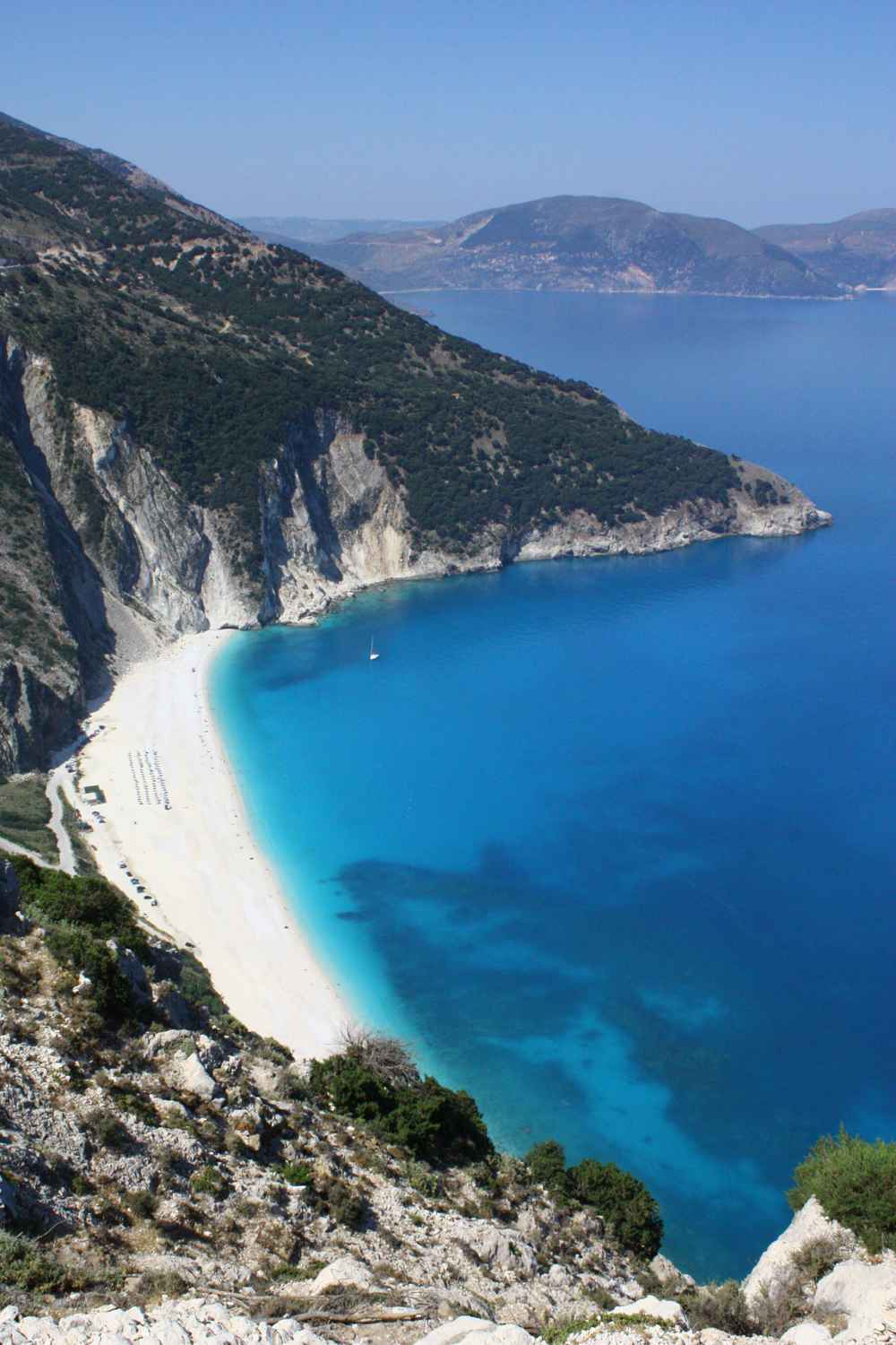
What is the winding access road down to Myrtos beach like?
The access road to Myrtos drops about 2 km from the coast road at Divarata to the beach, falling roughly 150 metres in a series of hairpins.
The road to the beach leaves the main coast road at Divarata, next to the upper viewpoint. From there it drops about 2 km to the sand, cut into the cliff in a run of hairpin bends. The lane is paved but narrow, with room for one car at most of the tight turns. Passing places sit at the wider corners, where drivers pull in to let oncoming cars through. The gradient stays steep the whole way, so low gears keep the descent controlled. The surface holds loose grit at the edges after winter storms. Near the bottom the road straightens and runs the last stretch behind the beach.
The whole descent takes about 5 minutes by car at a slow, steady pace down the cliff.
Driving the Myrtos road calls for care, because the bends are tight and the drop to the sea is steep. Oncoming cars meet at blind corners, so a horn tap before each hairpin warns anyone climbing the other way. In July and August the traffic thickens, and cars sometimes queue at the passing places on the way down. Hire cars, scooters and quad bikes share the lane, moving at walking pace on the sharpest turns. Brakes work hard on the descent, so gentle, steady pressure and low gear keep them cool. The road carries no lighting, so a return after dark runs on headlights alone.
Confident drivers manage the descent without trouble at a slow pace, and the surface stays sound. Rain makes the bends slick, so speeds drop further in wet weather.
Parking at Myrtos spreads across a gravel area behind the beach and along the final stretch of road. The main lot holds a limited number of cars, and it fills by late morning through July and August. Latecomers park along the roadside above, then walk down the last stretch to the sand. A canteen stands near the parking area, serving drinks and snacks through the summer season. Scooters and quad bikes find space more easily than cars at busy times. Arriving before 11am or after 4pm gives the best chance of a space near the sand. The parking sits only a short, flat walk from the water, unlike the long descent by road.
No fee booth operates on the public gravel, though this can change from season to season.
Reaching Myrtos without a car is harder, because no regular public bus stops at the beach. Taxis run from Argostoli, Sami or Fiskardo, and drivers arrange a pickup time for the return. Walking down from Divarata runs about 2 km each way on the road, but the climb back is steep and shadeless. Organised day trips and boat excursions reach the bay from ports such as Sami and Agia Efimia. Cyclists tackle the descent, though the climb out tests the legs on a hot day. A scooter or quad bike handles the narrow road well and parks easily at the bottom.
Most visitors drive their own hire car, since it gives the freedom to leave when the afternoon wind picks up. The nearest fuel is at Divarata and Assos.
How safe is swimming in the deep, quickly-shelving water at Myrtos?
Myrtos beach shelves steeply into deep water, so the seabed drops away within about 5 metres of the shore. Strong swimmers enjoy the clear, deep sea, but the sudden depth and afternoon swell call for care with children.
The seabed at Myrtos falls away fast, and the water reaches over head height within about 5 metres of the shore. The steep shelf means bathers are out of their depth after two or three steps, unlike the long shallows of Xi or Makris Gialos. Strong swimmers value the deep, clear water close in, with no wading needed to reach open sea. Weaker swimmers and children stay in the narrow shallow band right at the pebble edge. The drop-off runs the length of the beach, so the depth changes little from one end to the other. The clear water shows the shelving floor plainly, which helps bathers judge where the bottom drops.
Entry is easiest at the centre, where the finest sand gives firmer footing before the drop.
The open bay at Myrtos catches swell and wind, because it faces the west and northwest with no shelter offshore. Mornings often stay calm and glassy, then an afternoon breeze, the maistros, builds waves from the northwest. On windy days the surf breaks over the steep pebble shelf, pushing bathers back and stirring the shallows. The undertow off the shelf pulls at the legs when waves drag the pebbles seaward. Swimmers check the sea state before entering, and stay near shore when the surf runs. A red flag, when flown, warns against swimming, and bathers heed it. Calm returns by evening as the wind drops, and the water flattens again.
The safest swimming falls in the morning hours, before the daily wind fills the bay.
Myrtos has no natural shade, since the beach is open pebble and sand with no trees behind it. Sunbeds and umbrellas are set out in rows through the summer season, giving the only reliable cover on the sand. A canteen near the parking sells water, cold drinks and snacks, so bathers need not climb the road for supplies. Visitors bring a hat, water and strong sunscreen, because the white ground reflects heat and light. The cliffs throw a strip of shade at the north end only in the late afternoon, as the sun swings west. Rented umbrellas fill quickly on hot days, so early arrivals secure the front row.
No showers or large facilities stand on the sand, beyond the canteen and seasonal toilets. Midday sun is strong here from June to September.
Families use Myrtos in the calm morning hours, keeping young children in the shallow band at the pebble edge. The steep drop-off means non-swimmers stay within standing depth, close to the shore. Water shoes protect feet on the pebbles and help footing on the shelving entry. Bathers watch the afternoon wind, leaving the water when the swell builds over the shelf. Lifeguard cover is not guaranteed, so swimmers judge their own limits and mind the depth. The clear water aids visibility, but the quick shelf and open aspect keep Myrtos a beach for confident bathers when the sea rises. Parents keep children in sight at the waterline, away from the drop.
On calm days the bay stays safe and easy; on windy afternoons the same water turns rough.
What facilities does Myrtos beach in Kefalonia offer visitors?
Myrtos beach runs an organised section in summer with rows of sunbeds, umbrellas and a canteen near the parking area. The bay has no natural shade, so the umbrellas provide the only cover on the pebbles.
The organised part of Myrtos sits on the flatter pebbles near the foot of the access road, about 30 km north of Argostoli. Two rows of sunbeds face the water, each pair sharing a straw umbrella anchored firmly into the stones. Staff set out the loungers in the early morning and stack them again before dusk. The pebbles are large and smooth, so most visitors wear water shoes and step carefully toward the shoreline. The beach shelves quickly into deep water, so families with young children stay on the loungers close to the canteen. Renting a pair of sunbeds with a shared umbrella covers the full day.
The crew shifts the umbrellas as the west wind turns across the open bay through the warmer afternoon hours.
A single canteen stands behind the beach near the car park, built low against the cliff base. It serves cold drinks, water, coffee, snacks and light food through the summer season. The counter has no formal restaurant seating, so visitors carry cups and trays back to their sunbeds. Prices at an isolated beach canteen run higher than in Argostoli or Divarata, so visitors often bring a cooler with water and fruit. The canteen also sells basic beach items such as water shoes and inflatable rings when stock lasts. Shade beside the canteen is limited, and the queue grows around midday when the bay fills. Buying water early avoids the busiest lines.
The canteen closes in the evening once the sunbed crew clears the last loungers from the pebbles.
Myrtos has no natural shade at any hour, because the white pebble bank sits fully open beneath bare limestone cliffs. No trees, dunes or rock overhangs reach the shoreline, so the rented umbrellas give the only cover on the beach. Visitors arriving without a sunbed booking bring their own beach umbrella or a pop-up tent for shelter. The pale pebbles reflect strong light upward, so sun cream, a hat and sunglasses matter even under an umbrella. Around midday the heat on the open stones rises sharply, and the walk from the car park across the pebbles feels long without footwear. Swimmers cool off in the water and return to the shade in short spells.
The exposed setting is part of why Myrtos photographs so brightly from the clifftop road above.
Water shoes rank as the most useful item for Myrtos, because the pebbles are round and hard underfoot at the waterline. A refillable water bottle, a hat and high-factor sun cream handle the open exposure through the day. Since the bay has no rock pools or shallow flats, snorkellers swim out from the sunbed rows into clear, deep water. The canteen covers drinks and snacks, yet a packed lunch saves the walk back across the stones at midday. Myrtos appears on most lists of things to do in Kefalonia, so it draws steady numbers from late morning onward. Arriving with cash, footwear and shade planned in advance keeps the visit smooth.
The organised season with sunbeds and the canteen runs through the warm months and winds down as the swell rises.
When is the best time of day to visit Myrtos beach for light and photography?
Early morning and late afternoon give the calmest water and the softest light at Myrtos, while midday sun turns the bay its brightest turquoise. The clifftop viewpoint above Divarata frames the classic photograph from the road.
Morning visitors reach Myrtos before the wind builds, when the west-facing bay lies calm and glassy. The sun clears the eastern hills behind Divarata by mid-morning and lights the water from the side. Arriving around nine gives an hour of quiet before tour groups descend the switchback road from the clifftop. The pebbles stay cooler underfoot, and the sunbed crew has usually finished setting out the loungers. Swimmers find the sea flat and clear at this hour, with visibility running about five metres down the shelving bank. Early light also softens the white cliffs that frame the bay on both sides. Drivers coming the 30 km from Argostoli beat the midday queue for the small car park.
A morning start suits families who want shade time before the heat peaks.
Midday delivers the strongest colour at Myrtos, when the overhead sun drives light straight into the water. The white pebble seabed reflects that light back, so the bay glows in bands of turquoise and deep blue. Photographs from the clifftop viewpoint capture this contrast best between late morning and early afternoon. The trade-off is heat and crowds, since the car park fills and the beach loses its calm. Sunbathers rely fully on the rented umbrellas because the open pebbles carry no natural shade. The water stays cool against the strong sun, and the shelving bottom shows every shade of blue near the shore.
Drone-style road shots from above show the full curve of the bay and the cliffs behind. Midday rewards colour but demands sun protection and an early parking spot.
Late afternoon brings the light back down the cliffs and warms the tone of the whole bay. As the sun drops toward the sea, the west-facing beach faces the light head-on for the day’s warmest colours. The clifftop viewpoint on the Divarata road turns into the prime sunset spot, looking straight down the curve. Wind and swell often rise by this hour, so swimming grows choppier while the photography improves. Cars line the roadside pull-offs above the beach as visitors climb up for the wide view. The white pebbles hold a soft glow after the harsh midday glare fades away. Photographers frame Assos and its castle headland to the north in the same golden window.
Descending the switchback road before dark matters, since the narrow bends carry no lighting.
The classic Myrtos photograph comes from the clifftop viewpoint on the main road above Divarata, not from the sand. From that pull-off, the lens catches the full white crescent, the turquoise shallows and the cliffs in one frame. A short walk along the roadside barrier finds cleaner angles without power lines crossing the shot. The viewpoint sits roughly 150 metres above the water, so a wide lens captures the whole bay. Photographers return near sunset when the low sun rakes across the pebbles and deepens the blues. Down on the beach, close shots work best from the northern end looking back along the curve. Both viewpoints together tell the fuller story of the bay between Assos and Divarata.
Steady footing on the loose gravel shoulder keeps the roadside session safe near traffic.
Why does Myrtos beach in Kefalonia catch afternoon wind and swell?
Myrtos faces west into the open Ionian Sea, so the afternoon sea breeze and any western swell roll straight into the bay. The steep, shelving pebble bank then throws up short, sharp waves near the shore.
Myrtos opens directly toward the west on Kefalonia’s northwest coast, between Assos and Divarata. The bay faces the open Ionian Sea, with no island or headland breaking the horizon before the water reaches it. This exposure leaves the beach fully open to weather rolling in from the western sea. The cliffs curve around the back of the bay but give no shelter from wind coming off the water. Compared with east-coast beaches near Sami, such as Antisamos, Myrtos sits far more open to the prevailing flow. The same openness that lets afternoon wind in also gives the bay its wide, uninterrupted sea view. Morning calm and afternoon chop follow directly from this west-facing geography.
Understanding the aspect helps visitors plan swim times around the daily rhythm of the sea.
The afternoon sea breeze builds along this coast as the land heats and draws air off the water. By early afternoon the wind pushes onto the beach and roughens the surface of the bay. This daily pattern explains why morning swimmers meet calm water and afternoon swimmers meet chop. The breeze also cools the open pebbles, which gives relief from the strong overhead sun. On breezier days the umbrellas strain against their anchors, and the sunbed crew moves them to hold. The wind rarely reaches storm strength in summer, yet it changes the swim clearly after midday. Kite and wave watchers gather at the northern end where the gusts funnel along the cliffs.
Planning the swim for the first half of the day sidesteps the strongest afternoon breeze at Myrtos.
The pebble bank at Myrtos drops steeply into deep water only a short way from the shoreline. When swell reaches the bay, waves break late and hard against this steep shelf rather than rolling in gently. The backwash can drag loose pebbles and tug at swimmers standing in the shore break. On rougher afternoons a lifeguard flag system, where present, signals when conditions turn unsafe for weaker swimmers. Strong swimmers handle the deep water easily, while children stay near the sunbeds in the calmer morning hours. The steep profile also means the water deepens fast, so non-swimmers keep close to the shore.
Reading the sea before entering matters more here than on the shallow, sheltered beaches of the south coast. Respecting the shore break keeps a Myrtos swim safe on windier days.
Checking the forecast for wind direction and strength shapes a Myrtos visit better than any fixed plan. West and northwest winds push straight into the bay, while lighter or offshore days leave it calm all afternoon. On windy afternoons visitors move to sheltered east-coast beaches such as Antisamos near Sami, about 40 km away. Petani and Xi on the Paliki peninsula offer calmer swimming when the northwest wind is up. The morning window at Myrtos stays the surest bet for flat water and clear visibility. Deciding when to visit ties directly into where to stay in Kefalonia, since a base near the northwest coast makes early starts easy.
A short drive down from Divarata at dawn beats both the wind and the car-park queue. Flexibility around the daily breeze keeps every swim comfortable.


How can visitors combine Myrtos beach with Assos and Fiskardo in one day?
Myrtos, Assos and Fiskardo line up along the same northwest road, so one day links all three. Assos sits about 10 km north of Myrtos below its Venetian castle, and Fiskardo lies about 20 km north at the island’s tip.
Assos sits about 10 km north of Myrtos along the coast road, on a narrow isthmus below a Venetian castle. The small village wraps around a sheltered harbour, with pastel houses climbing the slope toward the pine-covered headland. A walking path leads up to the ruined fortress walls, which look down over the bay and the isthmus. Below the castle, the village keeps a quiet waterfront of tavernas and small pebble coves for swimming. The drive from Myrtos climbs back to the main road, then drops down a side turning to reach Assos. Parking sits above the village, since the harbour lanes stay too narrow for cars.
Visitors often pair a Myrtos swim with a slower lunch and stroll at Assos in the same morning.
Fiskardo sits at the northern tip of Kefalonia, about 20 km north of Myrtos along the same road. The harbour village survived the great Ionian earthquake that flattened most other towns on the island. Its Venetian-style houses in pastel colours ring a working port where yachts and small ferries tie up. Waterfront tavernas line the quay, and a short path leads to a lighthouse and the ruins near the point. Ferries connect Fiskardo with Lefkada and Ithaca across the strait during the summer season. The drive north from Myrtos winds through hills and villages, taking around 30 minutes without stops. Fiskardo works well as a lunch or late-afternoon stop after a morning swim at Myrtos.
The pastel harbour gives a clear contrast to the open, cliff-backed bay to the south.
A logical loop starts early at Myrtos for the calm morning swim before the wind and crowds arrive. From the beach, the road climbs to the clifftop viewpoint above Divarata for the classic photograph. A short drive north reaches Assos for a mid-morning walk up to the castle and a harbour coffee. The road then continues north to Fiskardo, roughly 20 km from Myrtos, for lunch by the port. Drivers cover the whole northwest string in one day without doubling back, since the three sit in a line. Returning south in the late afternoon allows a second stop at the Myrtos viewpoint for sunset light.
The full loop from Argostoli and back runs around 90 km, so an early start suits it. Fuel and water before setting off, since services thin out in the north.
Timing decides how much of the northwest coast fits into one day around Myrtos. Starting at dawn secures parking and a calm swim, then frees the middle of the day for Assos and Fiskardo. Slower travellers split the trio across two days and spend a full afternoon at Fiskardo’s harbour. The northwest road carries tour buses by late morning, so early drivers meet lighter traffic on the bends. Assos suits a relaxed lunch, while Fiskardo rewards an evening meal as the yachts light up the port. Each village adds to the range of things a visitor covers beyond the beach itself. A base in the north around Divarata or Assos shortens every drive along this coast.
Planning the order around the morning calm at Myrtos anchors the whole day well.
How do you reach Myrtos beach by car from Argostoli and where do you park?
Myrtos lies about 30 km north of Argostoli on the main northwest road toward Fiskardo. A steep, paved switchback turns off near Divarata and drops to two car parks behind the beach and the roadside viewpoint above.
The drive from Argostoli to Myrtos covers about 30 km and takes around 45 minutes on mountain roads. The route heads north out of the capital toward Sami, then branches onto the coast road for Fiskardo. Signs for Myrtos, Assos and Fiskardo mark the way, so navigation stays simple along the main line. The road climbs and winds through hills with long sea views over the northwest coast. Divarata village marks the turn-off, where a taverna cluster sits at the top of the access road. Fuel stations thin out north of Argostoli, so filling up before the drive saves a detour.
A hire car gives the most freedom for reaching Myrtos, since bus service to the beach stays limited. The mountain bends demand steady, unhurried driving both down to the bay and back up.
Drivers from Sami reach Myrtos in around 30 minutes, following the coast road north through Agia Efimia. From Fiskardo in the far north, the beach lies about 20 km south along the same winding route. Guests staying in Lassi or near Argostoli face the longest run at about 30 km each way. Lixouri visitors on the Paliki peninsula add the short ferry crossing to Argostoli before the northbound drive. Skala and the south-coast resorts sit farthest away, so an early departure makes the day trip work. The coast road links all these points, so most northwest itineraries pass close to Myrtos anyway. Agia Efimia and Divarata offer the nearest fuel and refreshment stops before the beach turn-off.
Building Myrtos into a northbound day toward Assos and Fiskardo keeps the driving efficient.
The access road to the beach drops from the main highway near Divarata in a series of steep switchbacks. The paved lane falls sharply toward sea level over roughly 2 km of tight, blind bends. Drivers take the descent slowly in low gear and sound the horn on the sharpest corners. The road narrows in places, so two cars meeting a bend edge past each other with care. Buses and larger vehicles move deliberately, which slows the line during busy midday hours. The climb back up in the afternoon taxes weaker engines, so a lower gear holds speed and control. The surface stays paved the whole way, unlike rougher beach tracks elsewhere on the island.
Patience on this short descent rewards drivers with the bay opening below at each turn.
Two parking areas serve Myrtos, one on the roadside at the clifftop viewpoint and one down behind the beach. The lower car park sits on flat ground near the canteen, a short walk across the pebbles to the water. This lot fills by late morning in summer, so early arrivals claim the closest spaces. The upper roadside pull-off at the viewpoint holds fewer cars and serves photographers stopping for the classic shot. Overflow parking spreads along the verges of the descent road, which tightens the bends further. A dawn or early-morning arrival avoids both the full lot and the slow queue on the switchbacks.
No large paid structure exists here, so the free gravel areas fill on a first-come basis. Planning the parking around an early start keeps the whole Myrtos visit calm.
Frequently Asked Questions
Is Myrtos beach sandy or pebbly?
Myrtos is a pebble beach, not a sandy one. The shore is a bank of white and pale-grey pebbles that shelve steeply into deep, clear water. The pebbles range from fine gravel near the waterline to larger, rounded stones higher up the bank. This white pebble bed reflects light upward and gives the bay its bright turquoise and deep-blue colours. Water shoes rank as the single most useful item, since the round stones feel hard underfoot and shift as you walk. The seabed close to shore stays pebbly and clean, with no seaweed patches or muddy stretches. Because the bank drops away quickly, the water deepens within about three metres of the shoreline.
Families with young children stay near the shallow edge and keep to the calm morning hours. The steep pebble profile also means waves break sharply against the shore on windier afternoons. The white pebbles, not sand, define the look and feel of Myrtos on Kefalonia’s northwest coast.
Is there shade at Myrtos beach?
Myrtos has no natural shade at any point on the beach. The white pebble bank sits fully open beneath bare limestone cliffs, with no trees, dunes or rock overhangs reaching the shoreline. The only cover comes from the rented umbrellas set out in rows across the organised section in summer. Renting a pair of sunbeds with a shared umbrella gives shelter for the day near the canteen. Visitors who skip the sunbeds bring their own beach umbrella or a pop-up sun tent for cover. The pale pebbles reflect strong light upward, so shade alone does not remove the need for sun cream.
A hat, sunglasses and high-factor sun cream matter even under an umbrella through the middle of the day. The heat on the open stones peaks around midday, when the walk from the car park feels long. Swimmers cool off in the sea and return to the umbrellas in short spells. Planning shade in advance keeps a Myrtos visit comfortable under the strong summer sun.
Is it safe to swim at Myrtos beach?
Myrtos is safe to swim for confident swimmers, with clean, clear water and a clean pebble seabed. The bank shelves steeply, so the water deepens within about three metres of the shoreline. Calm morning conditions suit all swimmers, when the west-facing bay lies flat before the afternoon breeze. By early afternoon the sea breeze builds and pushes swell onto the beach, which raises a sharp shore break. The backwash can drag loose pebbles and unsettle weaker swimmers standing at the waterline. Children and non-swimmers stay near the shallow edge and swim in the calmer early hours. Strong swimmers handle the deep water easily and enjoy the clear visibility off the bank.
On rough afternoons visitors move to sheltered east-coast beaches such as Antisamos near Sami. Reading the sea before entering matters more here than on the shallow southern beaches. Choosing the morning for a swim and respecting the afternoon shore break keeps Myrtos safe and enjoyable.
How far is Myrtos beach from Argostoli and Fiskardo?
Myrtos lies about 30 km north of Argostoli and about 20 km south of Fiskardo, on Kefalonia’s northwest coast. The drive from Argostoli takes around 45 minutes on winding mountain roads that climb through hills above the sea. From Fiskardo in the far north, the beach sits around 30 minutes south along the same coast road. Assos, the village below its Venetian castle, sits about 10 km north of Myrtos, between the two. Sami on the east coast lies around 30 minutes away by the coast road through Agia Efimia. The turn-off for the beach sits at Divarata village, where a steep access road drops to the shore.
Kefalonia Airport, about 9 km south of Argostoli, adds roughly 40 km to the total from arrival. A hire car gives the easiest access, since bus service to the beach stays limited. These distances place Myrtos within an easy day trip from most parts of Kefalonia’s coast.
Is there food or a canteen at Myrtos beach?
Myrtos has one canteen behind the beach near the car park, serving drinks and light food in summer. It offers cold drinks, water, coffee, snacks and simple food across the organised season. The counter has no full restaurant seating, so visitors carry cups and trays back to their sunbeds. Prices at an isolated beach canteen run higher than in Argostoli or Divarata village up the hill. Visitors often bring a cooler with water, fruit and a packed lunch to save the walk back across the pebbles. The canteen also stocks basic beach items such as water shoes and inflatable rings when supplies last.
Queues grow around midday when the bay fills, so buying water early avoids the busiest lines. Divarata at the top of the access road holds tavernas for a fuller meal before or after the beach. The canteen closes in the evening once the sunbed crew clears the last loungers. One canteen plus a cooler covers a full day at Myrtos.
Where is the famous Myrtos viewpoint?
The famous Myrtos viewpoint sits on the main coast road above the beach, near Divarata village. A roadside pull-off gives the classic photograph, looking straight down onto the white crescent and turquoise water. The viewpoint stands roughly 150 metres above the sea, so a wide lens captures the full curve of the bay. It sits at the top of the steep access road that switchbacks down to the beach and car park. Cars stop along the verge here, and a short walk finds cleaner angles without power lines crossing the frame. Late afternoon light suits the viewpoint best, when the low sun rakes across the pebbles and deepens the blues.
From this height, the cliffs, the bank and the sea read together in one sweeping frame. Photographers pair the roadside shot with close angles from the northern end of the beach below. The Divarata viewpoint gives the image most associated with Myrtos on Kefalonia’s coast.
Is Myrtos beach suitable for families with children?
Myrtos suits families best in the calm morning hours, before the afternoon wind and swell arrive. The beach shelves steeply into deep water, so young children stay near the shallow edge under close watch. The organised section rents sunbeds and umbrellas beside the canteen, which gives shade and a base near the water. Water shoes help small feet on the round pebbles, which feel hard and shift underfoot. Morning calm gives the flattest, clearest water, when the west-facing bay lies still before the sea breeze. By early afternoon the shore break sharpens, so families with toddlers pack up before the chop builds. The canteen covers drinks and snacks, though a cooler and packed lunch ease a longer stay.
Shade planning matters, since the open pebbles carry no natural cover through the strong midday sun. Sheltered southern beaches such as Lourdas or Makris Gialos suit very young children better on windy days. Early timing makes Myrtos a workable family beach on Kefalonia.